90-Degree Weather Is Here!

More Chaos In Japan
For those of you who were wondering why I was not at the Carlsbad Skywarn Spotter Training Class last night it was because I was at my daughters track meet. This was the first one that I have been able to attend this year because of my work schedule. She ran two races (200 yard dash) and placed third in both races. I am really proud of her since she has been battling asthma for the past year.
I am still awestruck by the events going on in Japan. Its still really hard to get a grip on that horrible situation.The Nuclear Fallout problem continues to escalate and threatens to injure and kill many more of the Japanese people. What a confusing mess that is, and there is no telling which way it will go at this time. I am hoping and praying that a cloud of radiation doesn't drift eastward across the Pacific Ocean and into the US.
This should serve as a stark reminder to us all of how fragile our lives really are. Mother nature seems to have gone into a rampage mode recently. There is a lot of talk going around about the possibility of additional catastrophic earthquakes, and volcanic eruptions occurring around the world in the near future. I have no idea if this will happen or not but it definitely has my attention.
Hot Weather For March.
Hot weather is on tap for us here in SE NM for the next three days with our afternoon high temperatures forecast to climb up to near 90 to the low 90's. Its time to start watering the yard and try to get it to green up since mother nature doesn't seem to enthusiastic about giving us any rain.
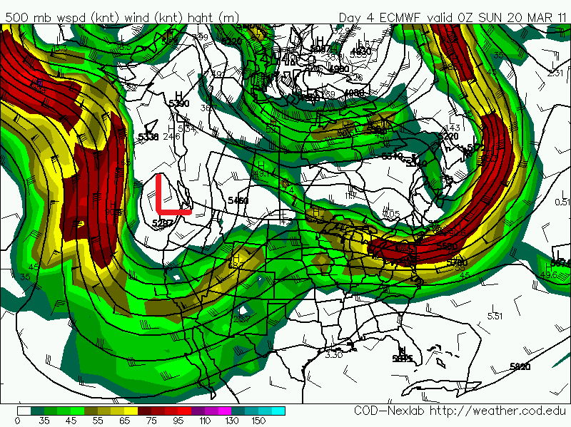
A strong long wave upper-level trough of low pressure is forecast to dig southward along the West Coast of the US late this week and into the weekend. As this happens the dryline will develop across SE NM and W TX Friday night into Saturday night. This will give us a slight chance for thunderstorms near the state line on Saturday. Some of these thunderstorms may become severe with the possibility of a few supercell thunderstorms in W TX. If conditions are right then my wife and I may get out and chase some of these storms. More on this later.
This next strong upper-level storm will sweep across the state during the Sunday-Tuesday time frame. Thus another high wind, and dangerous fire weather event looks likely across the area next Monday and Tuesday.
The Truth Is Stranger Than Fiction!


Comments
Post a Comment
Your comments, questions, and feedback on this post/web page are welcome.