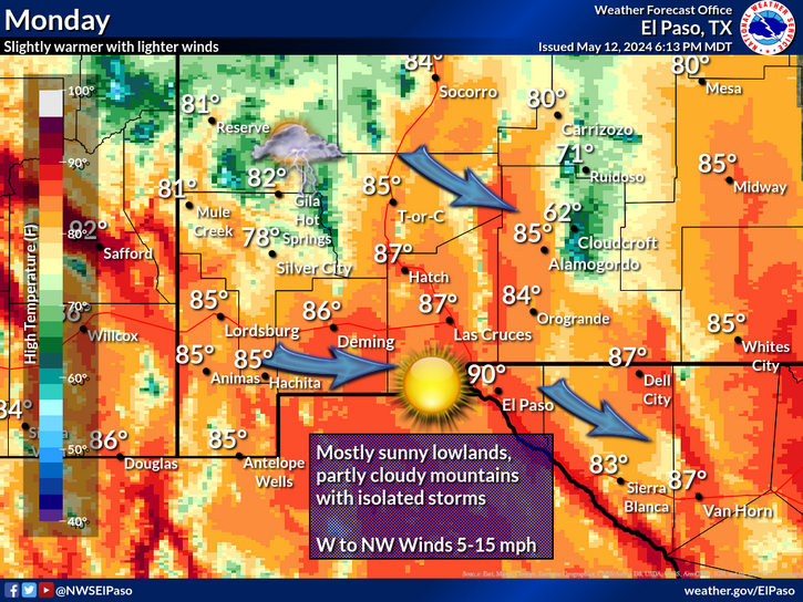
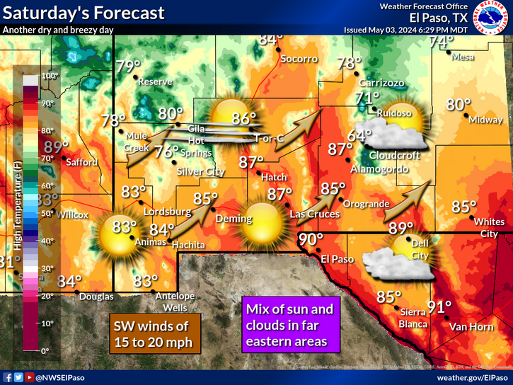
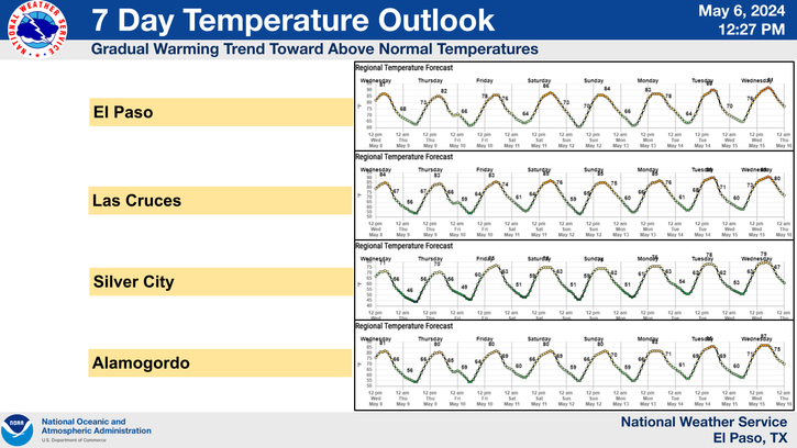
Las Conchas Fire As Viewed From The International Space Station 6-27-2011..
Click On The Photos To Enlarge Them.

"A crew member aboard the International Space Station, flying at an altitude of approximately 235 statute miles on June 27, 2011, exposed this still photograph of a major fire in the Jemez Mountains of the Santa Fe National Forest in north-central New Mexico near Los Alamos."

"Another image of the Los Alamos fire from the International Space Station."
By Gabriel Perna | Jun 28, 2011 08:56 PM EDT
"Once again, NASA was able to capture a natural disaster from outer space thanks to satellite technology.
Over the past decade, NASA has been able to get satellite images of earthquakes, tsunamis, tornados and much more. The most recent addition to this collection is a series of photos of the New Mexico and Arizona wallow fires.
Both NASA's Terra and Aqua satellites caught separate images of the New Mexico Las Conchas fire, which has blazed through 61,000 acres of land near Los Alamos, N.M in the north-central part of the state. In addition, the International Space Station caught two non-satellite images of the fire."
Follow Gabriel Perna on Twitter at @GabrielSPerna
----------------------------------------
Las Conchas Fire Update-
( At 9:30 PM MDT Tue Jun 28, 2011)
Near Los Alamos, NM.
60,741 Acres Burned.
3% Contained.
Donaldson Fire Update-
(9 PM MDT Tue June 28, 2011)
South Of Hondo, NM In Lincoln County.
15,000 Acres Burned.
0% Contained.
Little Lewis Fire Update-
(9:00 PM MDT Tue June 28, 2011)
8 Miles South Of Mayhill, NM In Otero County.
150 Acres Burned.
Residents of Sacramento & Weed Evacuated.
0 % Contained.
The Truth Is Stranger Than Fiction!


Comments
Post a Comment
Your comments, questions, and feedback on this post/web page are welcome.