Some Relief On The Way From The Searing Heat.
Click On The Maps To Enlarge Them.
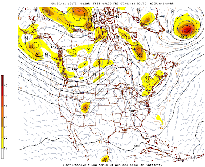
Valid At 6 PM MDT Today.
Upper level trough of low pressure is forecast to swing
across Northern New Mexico today. The Upper level ridge
will get nudged to our east today.
Valid At 3 PM MDT Sat July 2, 2011.
By Saturday the upper level ridge is forecast to located over
the Four Corners Region. With the center of the upper level
ridge shifting off to our north, we should see a afternoon high
temperatures drop down into the 90's for the weekend.
Tropical Storm Arlene was located 45 miles SSE of Tampico,
Mexico at 9:00 AM MDT this morning. Arlene has sustained
winds of 65 mph with gusts to 75 mph. Her central pressure is
994 MB/29.35". Arlene is moving onshore.
Where Is Our Monsoon?
A weak monsoonal surge of moisture can be seen streaming
northward out of Mexico into Eastern Arizona, and Western
New Mexico on the Water Vapor Satellite Image above.
This is indicated by the grey and purple shaded area.
The red areas on the map are pockets of dry air.
Remnant moisture from Tropical Storm Arlene is
forecast to remain over Central Mexico today
and tomorrow. Some of this moisture may
get drawn northward into NM by the
weekend. However, a strong influx
of this moisture is not forecast.
----------------------------------------------
New Mexico Fires.
(9:00 AM MDT This Morning)
Burning near Hondo, NM.
43,290 acres have burned.
Five structures have burned.
Little Lewis Fire-
(Update 11:00 AM MDT This Morning)
5% contained.
1,000 - 1,200 acres burned.
2 miles south of Sacramento, in Otero County.
(Update 11:00 AM MDT This Morning)
5% contained.
1,000 - 1,200 acres burned.
2 miles south of Sacramento, in Otero County.
"The following evacuations are in effect:
The Sacramento Methodist Assembly; the communities of Sacramento and Weed; Seep, Agua Chiquita and Ehart Canyon, and Camp of the Tall Pines.
The Evacuation Center is located at: Cloudcroft High School Gym"
(10:00 AM MDT This Morning)
3% contained.
Burning near Los Alamos, NM.
Approximately 92, 735 acres burned.
For information on other fires burning
in New Mexico please visit this link-
The Truth Is Stranger Than Fiction!






Comments
Post a Comment
Your comments, questions, and feedback on this post/web page are welcome.