Roswell Got Wet Last Night.
Click On The Maps To Enlarge Them.
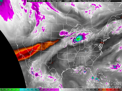
This mornings water vapor satellite image above, shows the
summer monsoonal flow continuing to stream northeastward
out of Mexico and across New Mexico.
Hurricane Dora reached Category 4 status yesterday with
sustained winds of 155 mph along with higher gusts. This
morning she is a Category 1 with sustained winds of 85
mph. Dora is forecast to continue to rapidly weaken as
she moves off to the NW at 9 mph over colder waters.
Valid From 6 AM Today - 6 AM Wed.
Today Will Be A Repeat Of Yesterdays Weather.
Not much has changed in the overall setup from yesterday.
Scattered t-storms are forecast to once again develop later
this afternoon, and continue well into the evening hours.
These storms will be of the hit and miss variety so not
everyone will see rainfall. This pattern will continue
into the weekend. The mountains will have the
best chance for rain.
A Flash Flood Watch goes into effect for Lincoln
County at noon today, and will be valid until late
this evening. Scattered t-storms will be capable
of producing locally heavy rainfall across the
Sacramento Mtn's today, which may lead to
localized flash flooding, especially over and
near the burn scar areas.
---------------------------------------------------------------------------
Local Rainfall Totals-
Chaves County-
8-Mile Draw Raws .96"
Roswell Climate .73"
0.3 SSW Downtown Roswell .53"
Roswell Arpt ASOS .20"
7.6 NNW Roswell .09"
Lincoln County-
Sierra Blanca Snotel .50"
Ruidoso Climate .13"
Ruidoso PWS 5659 .04"
Otero County-
0.6 S Pinon .70"
4.9 NNE Cloudcroft .44"
0.4 ESE Cloudcroft .42"
Mayhill Raws .39"
Cloudcroft PWS 7382 .29"
16 ESE Cloudcroft - Mayhill .26"
Pierce Canyon - S of Cloudcroft .24"
Sillver Springs - NE of Cloudcroft .22"
4.0 E Cloudcroft .21"
Cloudcroft Climate .19"
Mayhill PWS 9878 .19"
Dry Canyon - E of Cloudcroft .16"
1.8 SW Cloudcroft .15"
2.3 S Cloudcroft .15"
Mescal Raws .09"
Sacramento Pk .05"
Cosmic Raws .04"
Rainfall Totals Are Courtesy Of-
------------------------------------------------------------
Acrey-Lookout Fire Complex 7-22-2011 8:00 AM
Posted on July 22, 2011 by Joel Arnwine
Today fire crews will use both direct and indirect suppression tactics working to contain the fires. There will be some burnout operations conducted on the fires today. Lookout Fire Crews will use both direct and indirect fire suppression tactics to fight the Lookout fire today. They are planning to conduct burnout operations off of Forest Road 69, 69A, 201 and 307. Smoke from these burnout operations will be visible from Queen, White’s City and possibly Carlsbad. Fire crews will also conduct small burnouts operations to secure fire containment lines and begin cold trailing (ensure the fires edge is cold and out) on the Acrey Fire.
Current Size: 6,430 acres
Summary: The fire is actively burning in steep, rocky, inaccessible terrain on lands managed by the US Forest Service southwest of Carlsbad, NM.
1 Air Attack, 1 Lead Plane and heavy Air Tankers will be available to work the fire today. A Type 3 helicopter is also available to assist the fire resources.
Fire Behavior: Moderate fire behavior is expected today
Weather: Today…Mostly sunny. Highs around 90. Southeast winds 10 to 15 mph.Tonight…Partly cloudy. Lows in the mid 60’s. East winds 10 to 15 mph.
Structures Threatened: 2 Residential and 4 other outbuildings are currently threatened by the fire
Resources: Resources from the Forest Service, Bureau of Land Management, Bureau of Indian Affairs, New Mexico State Forestry, and Eddy County volunteer departments responded. Approximately 295 personnel are assigned to the fire.
The Truth Is Stranger Than Fiction!


Comments
Post a Comment
Your comments, questions, and feedback on this post/web page are welcome.