Fall & Winter Outlooks.
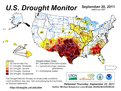
Current State Of The Drought.
Drought Outlook.
(Sept 15th - Dec 31st.)
How Much Rain Would It Take To Get Us Back To "Normal"?
(SE NM 6" - 9")
---------------------------------------------------------------------------------
October 2011 Outlooks-
Temperature Outlook For Oct 2011.
Precipitation Outlook For Oct 2011.
-------------------------------------------------------------------------------
2011 Fall Outlook-
Temperature Outlook For Oct - Dec 2011.
Precipitation Outlook For Oct - Dec 2011.
-----------------------------------------------------------------
2011 - 2012 Winter Outlook-
Temperature Outlook For Jan - Mar 2012.
Precipitation Outlook Jan - Mar 2012.
Our outlook for the fall and the winter looks very bleak as far as precipitation is concerned. The worst drought in the history of the state continues to grip New Mexico, with southeastern New Mexico being one of the hardest hit areas.
Badly needed rains fell across the area a little over a week ago. Although moderate to heavy rainfall fell across the area (most places across E & SE NM received between 1/2 of an inch, to a little over 3 inches of rainfall), the rainfall barley put a dent in the ongoing historic drought.
For September, I have recorded 2.12" of rainfall, this brings my year to date (YTD) total to 3.51". The new 30 year climate normals for the Carlsbad Climate Coop Station, are 2.11" for September, and 10.81" for Jan - September.
There have only been two months in the last year in the local area that have received average rainfall. This was February, and this month. It would generally take an additional 6" to 9" of rainfall just to bring our rainfall totals up to "normal".
My rainfall totals are fairly representative for most of SE NM. A few spots have had more rainfall than I have, but not many, and quite a few places have received even less than I have.
For additional rainfall totals please visit CoCoRaHS. Or the Midland NWS Climate Page, the Albuquerque NWS Climate Page, and the El Paso NWS Climate Page.
Overall it appears that a warmer than normal, and drier than normal fall and winter are on tap for southeastern New Mexico and nearby west Texas. La Nina conditions continue to re-develop across the equatorial Pacific, therefore the odds are that this historic drought will continue into next spring.
For additional information concerning this historic drought and the outlooks for west Texas and southeastern New Mexico, please click on these links. Texas and New Mexico Drought Information, and Drought Conditions Persist.
The Truth Is Stranger Than Fiction!






Comments
Post a Comment
Your comments, questions, and feedback on this post/web page are welcome.