New Mexico Is Getting Hammered By A Major Winter Storm!
Click On The Maps to Enlarge Them.
Blog Updated At 6:40 PM MST.


My Home In Carlsbad, NM At 5:16 AM MST This Morning.

"As an upper level storm system approaches the area tonight, heavy snow over the Guadalupe Mountains and southeast New Mexico will spread south and east across west Texas. Snowfall will likely continue for much of the region through Saturday morning. A gradual decrease in snowfall amounts is expected Saturday afternoon.
A Winter Storm Warning for heavy snow is in effect for the Guadalupe Mountains, southeast New Mexico Plains, northwest and west portions of the Texas Permian Basin and the Van Horn and Highway 54 corridor through Saturday evening. Snow accumulations of 3 to 5 inches are forecast across the warned area. Isolated amounts up to 6 inches are possible across the higher elevations of the Guadalupe Mountains.
Farther south and east across the Davis Mountains, portions of the upper Trans Pecos, Permian Basin and western low rolling plains, snow accumulations of 1 to 3 inches are forecast through Saturday evening.
A Winter Weather Advisory is in effect for the the above areas through Saturday afternoon. The storm system is making a very slow progression across the region. This could result in a prolonged period of wintry weather leading into Christmas. Travel conditions will likely be impacted across west Texas and southeast New Mexico."


RUC 500 MB Analysis At 5 AM MST This Morning.
Major Winter Storm Shuts Down Roads
Across Many Areas Of New Mexico!
1 - 800 - 452 - 9292
1 - 800 - 432 - 4269
Continues In Effect for Eddy County,
And The Guadalupe Mtn's,
Until 5 PM MST Christmas Eve.
New Snowfall Accumulations 5" - 6"
Locally Heavier Amounts Expected.
Areas Of Heavy Snow & Blowing Snow.
Difficult & Dangerous Driving Conditions.
Some Road Closures Possible.
Continues In Effect For Lea County,
Until 5 PM MST Christmas Eve.
New Snowfall Accumulations 2" - 4".
Areas Of Heavy Snow & Blowing Snow.
Difficult & Dangerous Driving Conditions.
Some Road Closures Possible.
Chaves & Lincoln Counties,
Until 11 PM MST This Evening.
New Snowfall Accumulations 3" - 8".
Locally Heavier Totals Above 7,500'.
Lesser Amounts Below 7,500'.
Areas Of Heavy Snow & Blowing Snow.
Difficult & Dangerous Driving Conditions.
Some Road Closures Possible.
Otero County,
Until Midnight Tonight.
New Snowfall Accumulations 6" - 10".
15" Or More On Mid-Level East Slopes.
Areas Of Heavy Snow & Blowing Snow.
Difficult & Dangerous Driving Conditions.
Some Road Closures Possible.
Snowfall Reports As Of 6:30 PM MST-
(Additional Snowfall Totals Will Be Listed As They Become Available.)
Ski Apache 16" Storm Total 18"
High Mesa - Near Alto Country Club 12" - 14"
Cloudcroft 13"
4.9 Miles NE of Cloudcroft 12.9"
Angus 12"
2 Miles S Alto 11.5"
0.4 Miles ESE of Cloudcroft 11.3"
4 Miles NNE of Ruidoso 10"
Ruidoso 10"
Vaughn 9"
Sierra Blanca Snotel Near Ski Apache 8"
(7 AM Report)
2 Miles N of Alto 8"
Jct St. Rd's 37 & 48 7" - 8"
16 NE of Dunken 6"
29 Miles S of Yeso 6"
T or C 6"
Artesia 4"
Artesia 4"
Sumner Lake 4"
Capitan 4"
Pinon 4.0"
Picacho 3.1"
14 Miles NW of Carlsbad 3"
2.1 NNW Downtown Carlsbad 3"
NE Las Cruces 3"
El Paso N Hills 2.8"
Atoka - 4.8 SSE of Artesia 2.5"
NE El Paso 2"
4 Miles N of Roswell 2"
1 Mile NW of Roswell 2"
Roswell Co-Op Observer 2"
Public Report In Lakewood 2"
East El Paso 1.5"
Hagerman 1.5"
Public Report - South Carlsbad 1.5"
1" - 1.5" Around Carlsbad
1" - 1.5" Cottonwood - North of Artesia
El Paso Airport 1.1"
Snowfall Reports Are Courtesy Of-
A Powerful Winter Storm was centered over southeastern Arizona this morning. It is forecast by the models to make a slow crawl eastward, it may even take a little bit of a southeastward turn towards SE NM today into Christmas Eve.
I won't be surprised if this storm dives a little further to the south than what the models are forecasting, and tracks across northern Mexico to our south. This potent winter storm will continue to eject upper-level disturbances out ahead of the main core of the storm today into tomorrow, which periods of heavy snow at times occurring across the area.
Snow, heavy at times should increase once again across the area later this afternoon and continue overnight, and into tomorrow afternoon, as the potent upper-level storm enters SE NM.
Deteriorating conditions are forecast for tonight...with the worst of the storm impacting the local area tonight into Christmas Eve afternoon. Our temperatures are not expected to climb above freezing for most of the area.
The wet roadways today will quickly freeze over later this afternoon and tonight. With the additional heavy snowfall forecast to fall on top of the ice...some, if not many of our local roadways may be extremely dangerous if not downright impossible to travel upon.
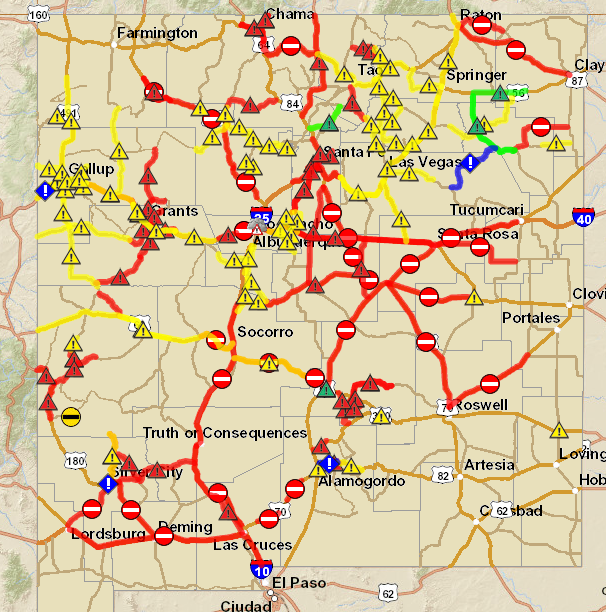
Areas of heavy snow, along with areas of blowing and drifting snow, and very poor visibilites, which will at times drop down to less than 1/2 of a mile, will create very dangerous, if not impossible driving conditions across much of the local area, as well across other parts of the state today into Christmas Eve. If you do not have to travel, especially tonight into Christmas Eve please don't. Please visit this link for the latest Road Conditions across New Mexico.
Dangerous wind chill values will develop across many areas of the state tonight into Friday as well. Some areas may see wind chill values below zero, will most of SE NM will experience wind chill values in the single digits and teens.
Please visit our local National Weather Service Offices via their web pages listed below.
The Truth Is Stranger Than Fiction!


Comments
Post a Comment
Your comments, questions, and feedback on this post/web page are welcome.