Significant Snowfall Possible Across SE NM Sunday Night.
Ruidoso At Sunrise This Morning.
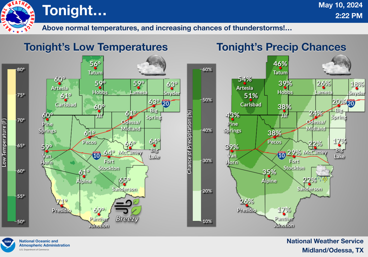
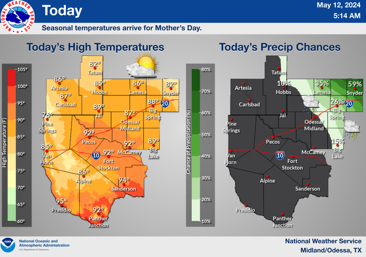
Map Is Courtesy Of The Midland NWS Office.
Map Is Courtesy Of The Lubbock NWS Office.
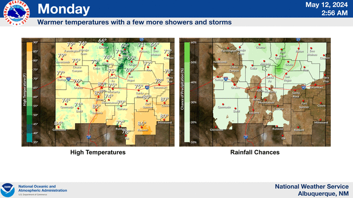
Maps Are Courtesy Of The Albuquerque NWS Office.
Map Is Courtesy Of The El Paso NWS Office.
This Mornings 12Z/5 AM MST GFS Snowfall Forecast Map.
Valid At 5 PM MST Monday, December 5, 2011.
Map Is Courtesy Of The Midland NWS Office.
Map Is Courtesy Of The Lubbock NWS Office.
Maps Are Courtesy Of The Albuquerque NWS Office.
Map Is Courtesy Of The El Paso NWS Office.
This Mornings 12Z/5 AM MST GFS Snowfall Forecast Map.
Valid At 5 PM MST Monday, December 5, 2011.
Wow, this mornings 12Z run of the GFS model is getting
a little excited about the snowfall potential across our
area. By Monday afternoon it is predicting 1" - 5" of
snowfall across the SE NM of New Mexico. Click on
the map, and take a look at the Sacramento Mtn's.
12" - 20" snowfall totals are being forecast!
Blog updated at 5:30 PM MST.
Round Two Sunday Into Monday.
Round 3 Monday Night.
Special Weather Statement From NWS MIdland.
Special Weather Statement NWS El Paso.
Special Weather Statement From NWS MIdland.
Special Weather Statement NWS El Paso.
Special Weather Statement From NWS Albuquerque.
Another arctic cold front will arrive tonight bringing much colder air back into SE NM. Our high temperatures will struggle to get out of the 30's and 40's on Sunday, and may not climb above 32F on Monday, and not much above freezing on Tuesday.
Meanwhile a deepening, and very cold upper-level storm will move towards the area Sunday night and Monday. Snow will break out across the Guadalupe Mountains by Sunday evening and then spread eastward and northeastward across the lower elevations of SE NM. Current indications are that the Guadalupe's may see 1" - 3" of snow by sunrise Monday, and Eddy and Lea Counties may at least see a couple inches of the white stuff.
By sunrise Monday a mix of rain and snow may change over to all snow across the area. Thunderstorms will also be possible. A second upper-level disturbance will enter the area Monday night and this will keep the snows going across the area into Tuesday. By Wednesday morning low temperatures across the northern mountain valleys could plunge down to -15F. Yet another arctic plunge is forecast by about next Friday.
This is continues to be a developing situation, and I will keep you updated as new information becomes available.
-----------------------------------------------------------------
My hat is off to the Midland National Weather Service Forecasters this morning, they nailed our forecast with this storm here in SE NM. The warm air advection just above the arctic air at the surface won out, and basically kept us from receiving any decent snowfall totals here in the Pecos Valley as well as the rest of SE NM. It snowed just enough at my house here in Carlsbad last night to dust the chairs and grass in my yard in spots (a trace amount of snow) with a very light coating of the white stuff. I don't even have ground cover but that's what they were calling for.
Ski Apache is reporting 8" of new snow as of 2:45 PM.
Snowfall totals from across the area include-
5 Miles SW Bonito Lake 11.0"
1.8 Miles SW of Cloudcroft 8"
0.4 Mile ESE Cloudcroft 7.4"
2.3 Miles S of Cloudcroft 7"
3 Miles NE of Ruidoso 7"
16 Miles SE of Corona 6.5"
2 Miles SSW of Alto 6"
0.8 Miles SE of High Rolls 4"
Capitan 4"
Fort Sumner 4"
Fort Stanton 3.5"
5 Miles W of Cloudcroft 3"
3 Miles SSW of Encino 3"
1 Mile WSW San Patricio 2.0"
6.8 Miles NNW Alamogordo 1.0"
6 Miles NNW Dunken 1"
2 Miles SW of Portales 1"
1 Mile NW of Roswell .7"
0.6 Mile S of Pinon .5"
1 Mile NNE of Lakewood .3"
4.8 Miles SSE of Artesia - Atoka .2"
Rainfall Totals-
Sierra Blanca Snotel 1.10"
Carrizozo Airport .66"
Dog Canyon Raws .40"
McKittrick Canyon Raws .36"
Guadalupe Pass .21"
Sierra Blanca Regional Airport .17"
Artesia Airport .15"
2.1 Miles NNW Downtown Carlsbad .13"
10 Miles ESE Hagerman .13"
Roswell Airport .13"
NW Hobbs - KM5BS .12"
Queen Raws .11"
Carlsbad Airport .10"
Rain and snowfall totals are courtesy of-
CoCoRaHS
New Mexico MesoWest Wx
Midland NWS Climate Summary
Albuquerque NWS Event Summary Page
As a hint at what is coming our way Sunday night into Monday, the Midland National Weather Service Forecasters are talking about the possibility of significant snowfall totals across SE NM in their Area Forecast Discussion this morning (AFD). They are not the only ones either, the Lubbock, Albuquerque, and El Paso Offices are already discussing this next bout of winter.
We are going to see a warm-up today with our afternoon highs climbing up into the 50's. A second arctic cold front will arrive Sunday, bringing with it the coldest airmass of the season. Our highs on Monday will likely fail to rise above freezing across most of the area.
As the first short wave exits stage right this morning, a second and colder upper-level disturbance located near Las Vegas, Nevada this morning, is forecast to drop southward, and into the base of the upper-level trough of low pressure across Arizona by this evening. The models then move it across the boot-heel of southwestern New Mexico Sunday afternoon and evening.
This next upper-level winter storm will be much colder than last nights storm. Forecast temperatures associated with this storm will be around -15C/5F at the 700 millibar level, or at 10,000' MSL. At the 500 millibar level, or 18,000' MSL temperatures are forecast to drop as low as -30C/-22F to -32C/-26F.
These temperatures will be much more favorable for the development of snow across the state. This combined with another intrusion of arctic air, and its associated low-level upslope flow will, set the stage for another winter storm to impact New Mexico Sunday into at least Monday.
SE NM and nearby areas have a better chance of seeing measurable snowfall with this next winter storm. I will keep my web page updated with the very latest details concerning this second inbound winter storm as they become available. I appreciate the visits to my web page and blogs everyone, thank you very much.
The Truth Is Stranger Than Fiction!






2" of snow fell from late yesterday to before dawn, up in the foothills. A nice, wet snow! The arctic air and E canyon winds here, not so thrilled, but if we can pull off some more wet snow, I will be happy.
ReplyDelete