Winter Storm Approaches Tonight.


RUC 500 MB Analysis At 11 AM MST This Morning.

 Radar snapshots off of "My SE NM Radar" on my web page.
An area of moderate to heavy rain, mixed with snow, continues
to expand across southwestern and western New Mexico.
Blog updated at 6:45 PM MST.
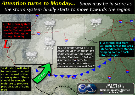
Significant Winter Storm For New Mexico.
Latest Web Briefing From NWS Midland.


An area of moderate to heavy rain, mixed with snow, continues
to expand across southwestern and western New Mexico.
Blog updated at 6:45 PM MST.
Significant Winter Storm For New Mexico.
Latest Web Briefing From NWS Midland.
Latest Special Web Briefing From NWS Lubbock.
Latest Web Briefing From NWS El Paso.
High Winds Across Southern New Mexico Last Night.
Guadalupe Pass is reporting light snow with freezing fog and a temp of 27 at 6:45 PM MST.
Latest Web Briefing From NWS El Paso.
High Winds Across Southern New Mexico Last Night.
Guadalupe Pass is reporting light snow with freezing fog and a temp of 27 at 6:45 PM MST.
Tonight into tomorrow, the first piece of the upper-level storm to our west, is forecast to eject eastward across the state. Round one of this winter storm will occur tonight into Saturday, round two on Sunday, and the third round on Sunday night into Monday.
The heaviest snows are forecast to fall from the Sacramento Mountains northeastward towards the Clayton area tonight into tomorrow, as well as across the northern Mountains of the state. Snow may mix with rain, freezing rain and sleet over Chaves County, and if this happens it will reduce their snowfall totals.
A wintry mix of precipitation consisting of rain, freezing rain, sleet, and snow is still in the forecast for tonight into tomorrow morning across southeastern New Mexico. A few thunderstorms are not out of the question either tonight. At this time the Midland National Weather Service Forecasters are forecasting very little accumulations of snow and sleet across Eddy and Lea Counties.
I think that it will be a close call tonight as to whether or not we see accumulating snowfall in Eddy, Lea, and Culberson Counties. Everything now depends upon the temperature profile of the atmosphere, from the surface to about 10,000'. The models have been forecasting for several days that a warm moist pocket of air would override the shallow arctic air at the surface. This has happened today, and is forecast to strengthen tonight.
Should the temperature's aloft cool more than the models are forecasting, then life will get really interesting around here. We would have a better chance of seeing sleet and snow, maybe even accumulating snows.
If the warm pocket of air does not erode out, and prevails, then a mixed bag of precipitation will occur as is currently being forecast. Looking at the radars to our west and north, it is clear that there is going to be some moderate, to heavy rain and snow totals across the area by tomorrow.
A Winter Storm Warning remains in effect until 5 PM Saturday for Chaves and Lincoln Counties, as well as eastern, northeastern, and most of the rest of the northern two-thirds of New Mexico. Lincoln County, and the higher elevations of Chaves County, are expecting 6" -12" of snow, as well as most of the rest of the eastern and northeastern plains. The Roswell area is now forecast to receive 1" - 4" of snow out of this storm, and this is also expected across Roosevelt and Curry Counties.
A Wiinter Storm Warning continues in effect for the southern Sacramento Mountains through 6 PM Saturday. Areas above 7,000' are forecast to receive 6" -12" of snow, while elevations below 7,000' are forecast to receive 2" -5". A Winter Weather Advisory is out for the Deming, Las Cruces, and Alamogordo areas.
As I have mentioned several times over the past couple of days, dangerous if not downright impossible driving conditions are anticipated tonight into tomorrow across many areas of New Mexico and parts of West Texas. This will be especially true in those areas under winter storm warnings and advisories. For the very latest road conditions across the state please visit this link.
When you click on the link on my main web page , be sure to click on the "winterize box" to transfer the radar image for the normal mode to the winter mode. If you want to just view my blogs, then bookmark this link...blogs, if you have a smart phone and view to view just my blogs on it then bookmark this link...mobile app.
The Truth Is Stranger Than Fiction!


Comments
Post a Comment
Your comments, questions, and feedback on this post/web page are welcome.