Warm Today - Warm & Windy Monday.


Today's Weather - Warm.
Most of you are going to love today's sunny warm weather. Our afternoon highs are forecast to range from near 70 in the Roswell area, to the low 70's in the Hobbs area, to the low-mid 70's in the Artesia-Carlsbad areas. Mid and high level clouds will filter in later this afternoon. Southerly to southwesterly breezes will pick this afternoon at around 10-20 mph.
Monday - Warm & Windy.
Blog updated at 3:25 PM MST Today-
Blog updated at 3:25 PM MST Today-
Guadalupe Mtn's Of SE NM & W TX..
In Effect Until 5 PM MST Monday.
SW Winds Increasing To 30-40G60 MPH.
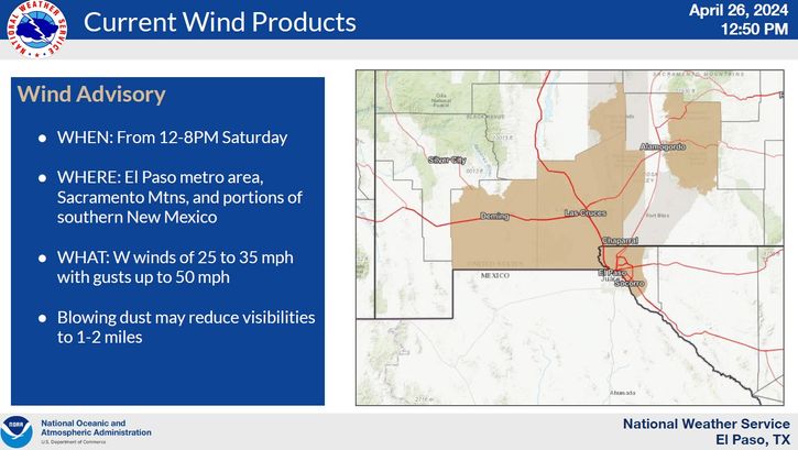
Wind Advisory Monday!
Eddy-Lea-Chaves-Lincoln-Otero Co's
SW Winds Increasing To 25-35G45-55 MPH.
Wind Advisory Monday!
Eddy-Lea-Chaves-Lincoln-Otero Co's
SW Winds Increasing To 25-35G45-55 MPH.
A shortwave trough of low pressure will swing across northern New Mexico and southern Colorado on Monday. This feature will cause the surface pressure gradient to tighten up, and will make for a windy day across SE NM and W TX.
Our first high wind event of the new year will unfold across the local area tomorrow. A Wind Advisory may be issued for Eddy County for tomorrow by the Midland National Weather Service Office. Southwesterly winds will increase across the area tomorrow, and by mid-day should be sustained at around 25-30G40 mph. A few higher gusts will be possible in a few locations, especially over and near the foothills and mountains.
Mid and high level clouds are forecast to increase across the area later this afternoon and into tonight, but these will clear out by tomorrow morning. A few areas of patchy blowing dust may occur in the stronger wind gusts tomorrow afternoon. Afternoon high temperatures tomorrow will range from the upper 60's to near 70 in the Roswell and Hobbs areas, to the low-mid 70's across the Artesia and Carlsbad areas. A few spots may be a little warmer and may reach the upper 70's.
Cold Front Arrives Tuesday Morning.

A cold front will work its way southward down the eastern plains of New Mexico Monday night, and will arrive in southeastern New Mexico early Tuesday morning. A cooler airmass will overspread the area on Tuesday with afternoon highs mostly in the 50's.
This cool down will not last long however. By Wednesday we will be back up in the 60's, and by Thursday and Friday most of southeastern New Mexico will see the low-mid 70's return. Interestingly enough our National Weather Service forecast high temps for next Saturday are near 80. A few of us may even see the low-mid 80's. It is still January right?
Brutal - Possibly Historic Cold Across NW Canada.

Valid At 5 PM MST Mon Jan 16, 2012.

Valid At 5 AM MST Wed Jan 18, 2012.

Valid At 5 AM MST Tue Jan 17, 2012.
Look at the forecast temperatures on the GFS 500 millibar, or 18,000' Mean Sea Level map above. Temperatures at this level are forecast to be as low as -48C/-54F over central Canada. That's very cold for a mid-level storm.
Surface temperature departures of 60-70 degrees below normal are still being forecast by the GFS model across northwestern Canada for the first of this upcoming week. Actual surface temperatures of -50F to -60F are being forecast by this model. I can't wait to see just how low these temperatures actually go this week.
Long-Range Change Coming - Back To Winter?

Valid At 5 PM MST Sun Jan 22, 2012.
In the world of weather nothing lasts forever. The atmosphere is a fluid, and is constantly changing. What goes up, will in time, come back down. Mother nature and old man winter have taken a break recently, keeping the jet stream and storm track well north of SE New Mexico. This will last perhaps until late next weekend, or the first of the following week.
Last nights 00Z/5 PM MST run of the European (ECMWF) forecast model (depicted above), has a trough of low pressure diving southward into central Arizona by late next weekend. Sound familiar? It should...this has been the storm track that has hammered our local area with multiple winter storms since the first of December. This may be out next potential weather maker.
Remember, I have been saying recently that as long as the jet stream does not buckle, and send another one of the strong upper-level disturbances southward into the Desert Southwest, we would remain free from these cold arctic intrusions from Canada. If this model forecast is correct, this all may be about to change, and we may see a return to colder and stormier weather in about a week or so.
The Truth Is Stranger Than Fiction!
My Web Page Is Best Viewed With Google Chrome.


Comments
Post a Comment
Your comments, questions, and feedback on this post/web page are welcome.