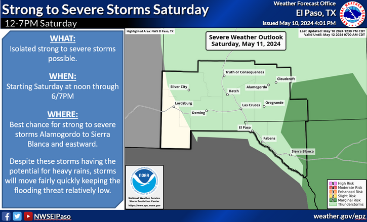
Rain & Higher Mtn Snows Coming Up - T-Storms Possible Too.

00Z/5 PM MSR ECMWF 500 MB Analysis Last Night.
Two pieces of upper-level energy (see the graphic above) will phase today to form a strong short wave trough of low pressure over the Pacific Northwest.

ECMWF 500 MB Forecast.
Valid @ 5 AM MST Thursday, Dec 19, 2013.
By sunrise Thursday morning this strong short wave trough of low pressure will be located over northwestern California. It will continue to strengthen as it closes off and digs southward.

ECMWF 500 MB Forecast.
Valid @ 5 PM MST Thursday, December 19, 2013,
We should be looking at a closed low just off of the coast of San Diego by sunset Thursday.

ECMWF 500 MB Forecast.
Valid @ 5 PM MST Friday, Dec 20, 2013.
By sunset Friday our storm should be located over the northern Baja Region in the form of a cutoff or closed upper-level low. Just how west and south it digs will be crucial to what types of precipitation will fall over New Mexico and nearby areas. If the storm digs to far to the south then much of the northern two thirds of the state may miss out of most of the wintry precipitation.

ECMWF 500 MB Forecast.
Valid @ 5 AM MST Saturday, Dec 21, 2013.
If last nights run of the European (ECMWF) model is correct the storm should bottom out over northern Mexico, just south of the New Mexico Boot-Hill by Saturday morning. This isn't for certain yet so there very well could be some changes to the storms track in the models today into Friday.

ECMWF 500 MB Forecast.
Valid @ 5 PM MST Saturday, Dec 21, 2013.
Our storm is forecast (by this one model run anyway) to open up and lift northeastward over the area on Saturday. By sunset Saturday it should be located near the Texas Panhandle.

ECMWF Temperature Forecast.
Valid @ 11 AM MST Sunday, Dec 22, 2013
Last nights run of the European (ECMWF) model continues its trend of keeping the bulk of the colder air north and out of the local area until Sunday. By this time the storm will have pulled off to the northeast of us. This is the main reason why we should see mostly, if not all, rain here in southeastern New Mexico. But again if the upper-level storm to our west slows down or stalls, then there is the chance that the colder air would arrive sooner, and thus a more interesting setup precipitation-wise for us.

ECMWF Total Precipitation Forecast.
Valid @ 5 PM MST Sunday, Dec 22, 2013.

ECMWF Total Snowfall Forecast.
Valid @ 5 PM MST Sunday, Dec 22, 2013.
Wet weather appears to be headed our way. According to the model soundings we could see a mix of wintry precipitation over the area starting Friday night and continuing into Sunday morning. A mix of rain, some of which may be heavy with local storm totals of 1" or more, and snow appear possible. At this time (unless the colder air can work its way into the local area sooner) the higher elevations of the Sacramento mountains have the best shot of seeing the heaviest snows. Some of us may see a mix of rain and snow Saturday night...but at this time it appears that this will only be light amounts. Isolated thunderstorms will also be in the cards...especially across parts of west Texas.
Snow levels are currently forecast to stay above 8,000' in the Sac's Friday afternoon. These levels will fall to 5,500' to 6,500' by Saturday morning. Snow levels are currently forecast to remain around 7,000' on Sunday. Snowfall totals across the higher elevations of the Sacramento mountains could be in the 5' to 10" range. This would include the Cloudcroft, Sunspot, and Ski Apache areas.
Until the storm arrives get ready for some warm and windy weather southeastern New Mexico. Carlsbad is looking at high temperatures today in the upper 60's, and the mid 70's for tomorrow. Artesia, Roswell, Hobbs, and Tatum will have similar readings.

Last Nights 00Z/5 PM MST ECMWF 500 MB Forecast.
Valid @ 5 AM MST Christmas Morning.

Last Nights 00Z/5 PM MST ECMWF 6-Hourly Max Temperature Forecast.
Valid @ 5 AM MST Christmas Morning.
Last nights run of the European (ECMWF) model continues to forecast a long-wave trough of low pressure to sweep across the state on Christmas Day. A cold front is also forecast to move into the area Christmas Eve and Christmas Day. So for now anyway it looks like Christmas Day will be turning colder and perhaps a bit windy in the morning as the cold front works it way south through the area. According to the ECMWF we will see high temps in the 40's. This too is subject to change.
The Truth Is Stranger Than Fiction!
My Web Page Is Best Viewed With Google Chrome.


Comments
Post a Comment
Your comments, questions, and feedback on this post/web page are welcome.