Tropical Storm Odile's Forecast Impacts On SE NM - Tuesday, Sept 16, 2014.


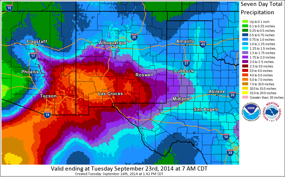
Latest National Weather Service model trends indicate that the remnants of Tropical Storm Odile may drop anywhere from 2.00" to 4.00" of rain across the southeastern New Mexico plains by the first of next week. According to the graphic above the Sacramento Mountains may get anywhere from 4.00" to 7.00" of rain by then. Remember these estimates are only a guide and are subject to change as later computer model data is available and forecasts are updated.

Today's 18Z/Noon MDT GFS Storm Total Rainfall Forecast.
Valid @ 6 PM MDT Sunday, September 21, 2014.

Today's 18Z/Noon MDT NAM-12 Storm Total Rainfall Forecast.
Valid @ 5 AM MDT Friday, September 19, 2014.

Today's 18Z/Noon MDT NAM/WRF Storm Total Rainfall Forecast.
Valid @ Midnight Friday, September19, 2014.
Tropical Storm Odile continues to move off to the north at around 7 mph as of 5:00 PM MDT this Tuesday afternoon. Odile will continue to slowly weaken especially after the storm moves inland into northwestern Mexico.
There remains some uncertainty as to just exactly how much rain will fall over southeastern New Mexico, southern New Mexico, and West Texas as the remnant moisture from Odile spreads over the area tonight into at least Friday...maybe into the weekend. But at this time it appears that the area will get hammered with some very heavy rains. Flash flooding and river flooding is a huge concern from tonight into Friday.
Given the fact that we are still saturated from recent rains over the past three weeks, and especially from last Friday and Saturday, any additional heavy rains will quickly produce flash flooding in and around the local area.
I have noticed that with each new computer model forecast run (a new run every six hours) the track of the remnants of Odile, and the heaviest storm total rainfall amounts gets shifted a little further to the east with time. So please check my web page often for the latest updates, forecasts, watches, and warnings concerning this potentially dangerous event.
The Truth Is Stranger Than Fiction!
My Web Page Is Best Viewed With Google Chrome.


Comments
Post a Comment
Your comments, questions, and feedback on this post/web page are welcome.