Winter Returns Monday Afternoon Into Next Week.
Potential For Major Winter Storm!
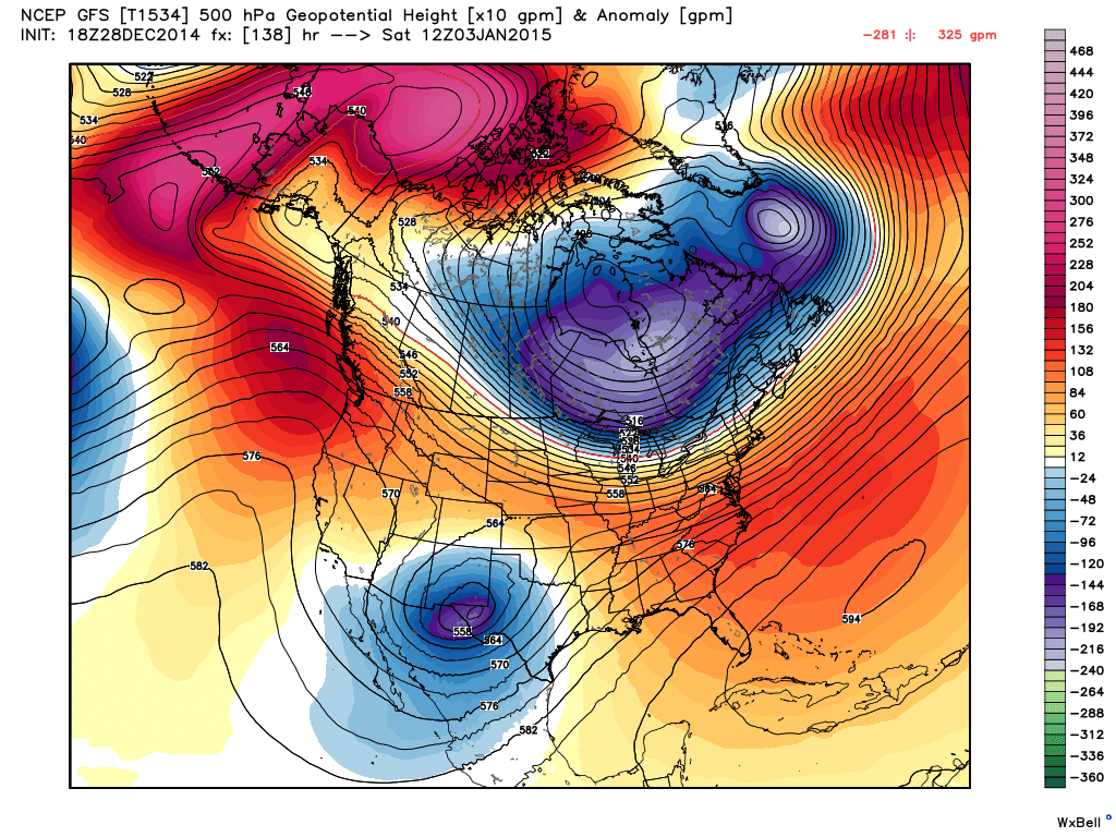
Valid @ 5 AM MST Saturday, January 3, 2015.
A powerful mid-upper level storm is forecast to develop over the Desert Southwest this week as it drops out of the Pacific Northwest, and closes off, becoming either a cut off low or a closed low. Just exactly where this storm tracks this upcoming week will be a key factor in determining its impacts upon New Mexico's weather.

Valid @ 11 PM MST Monday, December 29, 2014.

Valid @ 5 PM MST Wednesday, December 31, 2014.
First a strong arctic cold front is forecast to arrive in northeastern New Mexico Monday afternoon, then work its way southward down the eastern plains of the state and into southeastern New Mexico late Monday night or early Tuesday morning.
Much colder weather will be in store for the area starting Monday night and continuing into at least next Friday. With the track and timing of the approaching upper level storm still not nailed down, its not certain just how cold we here in southeastern New Mexico and nearby areas will get. But make no mistake a change to much colder weather is coming. For now it appears we at least see our high temperatures remain in the 20's and 30's from Tuesday into Thursday, maybe longer. Its still possible that we will drop below freezing Monday night or Tuesday morning and not get above freezing again until Thursday or Friday.


Valid @ 5 PM MST Sunday, January 4, 2015.
A mixed bag on wintry precipitation looks likely across the area Tuesday into the end of the week...maybe into next weekend. Again the details are uncertain at this time but it appears that we will have a mix of light rain, light freezing rain and drizzle, snow, and sleet. How much, where, and for how long is unknown. The latest run (18Z) of the US GFS Experimental model hammers parts of eastern, southeastern New Mexico, and West Texas with heavy snow late next week. Other models don't. I have a feeling that this storm is going to be difficult to forecast.


The Truth Is Stranger Than Fiction!
My Web Page Is Best Viewed With Google Chrome.


Comments
Post a Comment
Your comments, questions, and feedback on this post/web page are welcome.