Our Break From Spring Like Weather Is Over - Winter Has Returned.
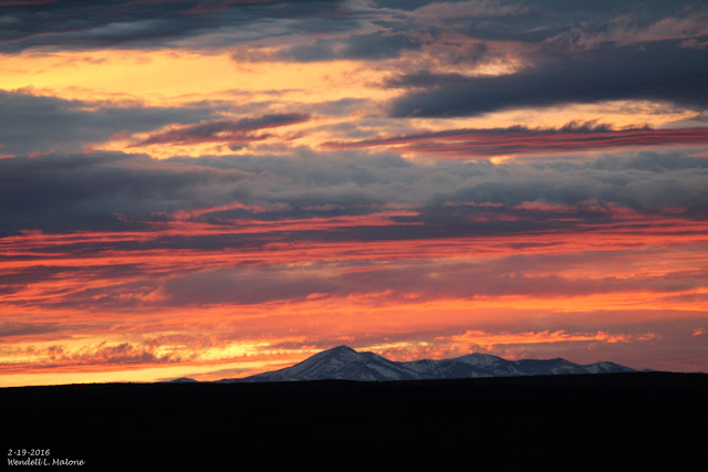
Sierra Blanca Peak At Sunset Friday, February 19, 2016.
As Of 9 AM MST This Morning.
As of 9 AM MST this morning a mid-upper level low was centered near Wichita Falls, Texas with a trough of low pressure and embedded disturbances located over New Mexico behind the storm. This is the storm that has produced the snow and rain over the state since yesterday.
A broken line of thunderstorms developed late yesterday afternoon across the Tularosa Basin and extended northeastward into northeastern New Mexico. This line of storms moved southeastward along and ahead of a cold front and into southeastern New Mexico early yesterday evening, producing frequent cloud to ground lightning strikes, light to moderate rain showers, and a few reports of small hail. Blowing dust also accompanied the storms. The 8-Mile Draw Raws Automated Weather Station located northeast of Roswell clocked a peak wind gust of 72 mph. The Carlsbad Airport reported a peak gust of 52 mph and the Artesia Airport reported a peak gust of 55 mph.
Light rain has started falling here in Carlsbad as of 9:45 AM MST this morning. Light rain is also being reported in Clovis, Roswell, and Artesia. According to radar snow is falling just north of Roswell northward into northeastern New Mexico and across parts of the Texas Panhandle and northern South Plains. Local web cams show that snow is falling in the Ruidoso area.
(Updated: As Of 3:00 AM MST Wednesday, Feb 24, 2016.)
• 8 W Raton - 12.0 in.
• 8 SSW San Miguel - 11.0 in.
• 8 SE Eagle Nest - 10.0 in.
• 8 SW Rociada - 10.0 in.
• Nambe - 9.0 in.
• 3 ESE Angel Fire - 8.0 in.
• 5 ESE Black Lake - 7.5 in.
• Tres Piedras - 7.2 in.
• 6 WNW Tererro - 7.0 in.
• Red River - 7.0 in.
• 1 WNW White Rock - 6.2 in.
• Angel Fire - 6.0 in.
• 7 E Canjilon - 6.0 in.
• 14 NE Gladstone - 6.0 in.
• 9 ENE Shady Brook - 6.0 in.
• 13 E Gladstone - 6.0 in.
• 5 NW Lamy - 5.7 in.
• 7 ESE Cuba - 5.0 in.
• 6 WNW Sugarite - 5.0 in.
• Glorieta - 5.0 in.
• 11 ENE Red River - 5.0 in.
• 12 N Grenville - 5.0 in.
• 7 E Albuquerque - 4.9 in.
• 6 NW Rosebud - 4.0 in.
• 8 NE Arroyo Seco - 4.0 in.
• 12 NNW Jemez Springs - 4.0 in.
• 5 SSE Santa Fe - 4.0 in.
• 8 E Albuquerque - 4.0 in.
• 9 E Cuba - 4.0 in.
• Eagle Nest - 3.5 in.
• 5 ESE Red River - 3.0 in.
• 2 SE Alto - 3.0 in.
• 5 NW Chama - 3.0 in.
• Roy - 3.0 in.
• 8 SSW Red River - 3.0 in.
• 4 E Sandia Park - 2.5 in.
• 1 ESE Abbott - 2.5 in.
• 2 SW Edgewood - 2.5 in.
• 2 S Edgewood - 2.0 in.
• Springer - 2.0 in.
• Vermejo Park - 2.0 in.
• 1 S Clines Corners - 2.0 in.
• 6 W Los Alamos - 2.0 in.
• Mountainair - 2.0 in.
• 5 NW Canones - 2.0 in.
• 6 WNW Espanola - 1.8 in.
• 8 ESE Albuquerque - 1.5 in.
• 3 NW Tres Ritos - 1.5 in.
• 2 S Arabela - 1.5 in.
• 6 NNW Guadalupita - 1.5 in.
• 1 SSE Glorieta - 1.4 in.
• 6 SSE Santa Fe - 1.3 in.
• 2 E Espanola - 1.2 in.
• Santa Fe - 1.1 in.
• 2 E San Pablo - 1.0 in.
• 7 SE Clines Corners - 1.0 in.
• 3 NNE Raton Crews Airport - 1.0 in.
• 4 N La Plata - 1.0 in.
• Questa - 1.0 in.
• Costilla - 1.0 in.
• Chama - 1.0 in.
• 7 ESE Kenna - 1.0 in.
• 2 N Chama - 1.0 in.
• 1 SSW Philmont Scout Ranch - 1.0 in.
• 1 SE Cerro - 1.0 in.
• 4 NNW Lamy - 1.0 in.
• 3 ENE Tucumcari - 1.0 in.
• El Vado - 1.0 in.
• 1 SSW Los Ojos - 1.0 in.
• 7 ESE Chupadero - 1.0 in.
• 1 ESE Truchas - 0.9 in.
• 1 ENE Santa Fe - 0.8 in.
• 6 SSE Santa Fe - 0.8 in.
• 3 SSW Santa Fe - 0.7 in.
• 2 WNW Manuelitas - 0.7 in.
• 1 WSW Santa Fe - 0.6 in.
• 5 N Edgewood - 0.5 in.
• 3 SE Farmington - 0.5 in.
• 3 NE Tucumcari - 0.5 in.
• 3 SSW Encino - 0.5 in.
• 1 WNW Navajo Dam - 0.4 in.
• 4 W Mountainair - 0.4 in.
• 5 NW Lamy - 0.3 in.
• 5 NW Lamy - 0.3 in.
• 2 N Milan - 0.3 in.
• 2 NNE Questa - 0.3 in.
• 4 NE Albuquerque - 0.3 in.
• 2 SW Agua Fria - 0.3 in.
• 1 W Santa Fe - 0.2 in.
• 5 S Albuquerque - 0.1 in.
• 1 SSW Tijeras - 0.1 in.
• 1 W Grants - 0.1 in.
The Truth Is Stranger Than Fiction!






Comments
Post a Comment
Your comments, questions, and feedback on this post/web page are welcome.