Continued Very Warm Through Wednesday - Rain Later Next Week?
GFS 500 MB (18,000' MSL) Forecast.
Valid @ 6 AM MDT Thursday, Nov 3, 2016.
European (ECMWF) 500 MB (18,000' MSL Forecast.
Valid @ 6 PM MDT Wednesday, Nov 2, 2016.
Canadian (GEM) 500 MB (18,000' MSL) Forecast.
Valid @ 6 AM MDT Thursday, Nov 3, 2016.
Our warm and dry October weather is forecast to continue into next Wednesday dominated by a stout ridge of high pressure aloft. By Thursday the GFS, ECMWF, and the GEM models agree that a cutoff upper level low (depicted by each model above at the 500 millibar level, or at 18,000' above seal level) will park itself just south of Arizona or southwest of New Mexico. Nothing unusual about this since these types of storms happen fairly frequently in the fall. By saying it is a cutoff storm this means that the storm itself is cut off from the jet stream flow which will remain well north of the state in Canada. When this happens these storms tend to move little or very slowly and have been known to produce heavy rain and snow across the state.
GFS Storm Total Rainfall Forecast.
Valid @ 6 AM MDT Saturday, Nov 5, 2016.
GFS Storm Total Snowfall Forecast.
Valid @ 6 AM MDT Saturday, Nov 5, 2016.
WPC Storm Total Rainfall Forecast.
Valid @ 6 AM MDT Saturday, Nov 5, 2016.
GFS 10-Day Temp & Rainfall Forecast For Artesia, NM.
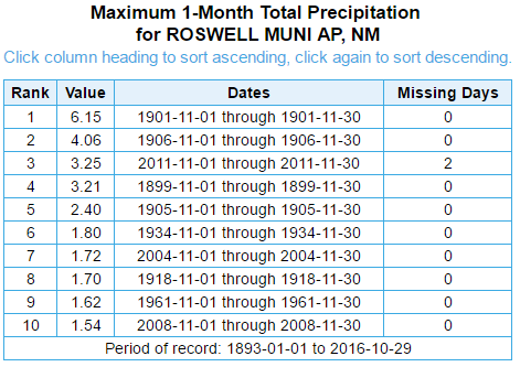
Heavy rain in November in New Mexico is not something we see a lot of. So when the models crank out 1" to 2" of rainfall from next Thursday into Sunday it catches my eye. Not that its impossible for this to happen, its not, it just does not happen that often.
Time to throw the caution flag up. These forecasts are 5-7 days out and there could likely be some changes as the models get a better handle of this storm. One thing appears pretty certain is that the airmass over the state will remain too warm for any significant snowfall through next weekend and this includes the northern mountains of the state.
The Truth Is Stranger Than Fiction!








Comments
Post a Comment
Your comments, questions, and feedback on this post/web page are welcome.