Another Round Of High Winds - Blowing Dust - Mtn Snows & Severe T-Storms.
Seasonal Temps But More Wind & Blowing Dust Tuesday & Wednesday.
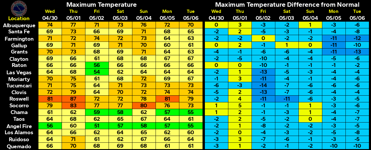
A Pacific Cold Front is forecast to swing eastward across the area on Tuesday. The dryline will setup across West Texas Tuesday afternoon and evening. Near seasonal temps are forecast Tuesday with highs mostly in the 70's and 80's. Highs behind the cold front will be in the 60's and 70's on Wednesday.
Valid At Noon MDT Today.
Next storm in line to affect the state and area was digging southward out of the Pacific Northwest at noontime today. There are some differences in the model forecasts concerning this storm's exact track and speed across the state.
GFS 500 MB Forecast.
Valid At 6 AM MDT Wednesday.
Canadian (GEM) 500 MB Forecast.
Valid At 6 AM MDT Wednesday.
European (ECMWF) 500 MB Forecast.
Valid At 6 AM MDT Wednesday.
All three models shown above form a cutoff low over the area by Wednesday morning. The European model is the furthest south with the storm. However none of these forecasts are far enough south and west of us to give us (Southeastern New Mexico) beneficial rains. In order for this to happen the center of the cutoff low would have to be located south of El Paso or thereabouts. Thus we (SE NM & W TX) should remain on the dry and windy side of this storm.
A surge northward of low level Gulf of Mexico moisture tonight into Tuesday evening. This combined with instability in the atmosphere complements of the approaching storm to our northwest will set the stage for severe weather late Tuesday afternoon and evening across parts of Texas and Oklahoma.
Valid At 7 PM MDT/8 PM MDT Tuesday Evening.
WRF-NAM Surface Dew Point Temperature Forecast.
Valid At 7 PM MDT/8 PM MDT Tuesday Evening.
WRF-NAM Simulated Radar Forecasts.
Valid At 7 PM MDT/8 PM MDT Tuesday Evening.
Valid At 9 PM MDT/10 PM MDT Tuesday Evening.
Given that the models aren't exactly sure yet where the cutoff low is going to end up Id use some caution when taking these forecasts (maps above) in consideration concerning severe weather Tuesday afternoon and evening. It fairly certain that it will happen but the problem is where do severe thunderstorms break out along and east of the dryline...meaning where will the dry line around sunset Tuesday evening? The further south the cutoff low digs into New Mexico then the further west the dryline will be pulled into West Texas. Right now it does not appear that Southeastern New Mexico will get in on the action.
Texas and Oklahoma will be the primary target areas of Tuesday's severe thunderstorms. Please check these local National Weather Service Web Page links on Tuesday for the very latest updates concerning this developing weather situation.
Ready For More Wind & Dust?
(Me Neither).
(Me Neither).
Current National Weather Service forecasts (as of 5 PM MDT Monday) are calling for southwesterly to westerly winds in increase to sustained speeds of 20 to 30 mph with gusts to 35-45 mph across the local Tuesday.
A High Wind Watch has been issued for the Guadalupe Mountains of Southeastern New Mexico and West Texas Tuesday and Wednesday for westerly winds sustained at 35 to 45 mph with gusts near 65 mph. This Watch will likely be upgraded to a High Wind Warning and we may possibly see additional Wind Advisory and or Warnings issued for parts of Southeastern New Mexico and West Texas on Tuesday.
A Blowing Dust Advisory and Wind Advisory have been issued for Southern New Mexico for Tuesday. Southwesterly winds are forecast to increase to sustained speeds of around 30 mph with gusts near 50 mph. Blowing dust is forecast to reduce the visibility down to under one half of a mile at times across some areas of Southern New Mexico Tuesday.
Localized areas of blowing dust may develop across Southeastern New Mexico and parts of West Texas Tuesday afternoon and evening. If the surface winds are strong enough we may also see another dust storm develop over Northern Mexico and spread northward and northeastward into the area...reducing the visibility and blotting out the sun like last Thursday's windstorm generated. However at this time it appears that this will be less likely to occur (unless the winds are stronger than forecast).
A High Fire Danger will exist across the area Tuesday with the very dry conditions, low relative humidity values, and strong winds. Once again please refrain from any type of outdoor activity that involves the use of sparks or flame. Any wildfire that develops will have the ability to rapidly spread and grow and may prove difficult to control or extinguish.
A Winter Storm Watch is in effect for parts of Northern Mountains of New Mexico and the Northeastern Plains for Tuesday afternoon into Wednesday afternoon. Some locals may see 10" or more of new snow.
(Tonight Through 6 PM MDT Wednesday).
The Truth Is Stranger Than Fiction!


Comments
Post a Comment
Your comments, questions, and feedback on this post/web page are welcome.