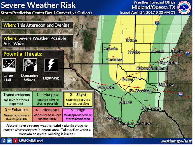
The Threat For Severe T-Storms Increasing Across SE NM & W TX.
(Issued At 10:30 AM MDT This Morning).
The threat for severe thunderstorms across Eastern and Southeastern New Mexico and parts of West Texas has increased this morning. Therefore the NWS SPC has upgraded the local area into a Slight Risk Category versus a Marginal Risk Category issued earlier this morning.
Large hail (Quarter size or larger), damaging thunderstorm wind gusts in excess of 58 mph, frequent deadly cloud to ground lightning, locally heavy rainfall that may lead to localized flash flooding will be possible with any severe thunderstorm that forms this afternoon and evening.
An isolated tornado or two cannot be ruled out late this afternoon especially with any discrete supercell thunderstorm that forms along and east of the dryline!
NWS SPC Outlook Update:
   Day 1 Convective Outlook
   NWS Storm Prediction Center Norman OK
   1130 AM CDT Fri Apr 14 2017

   Valid 141630Z - 151200Z

   ...THERE IS A SLIGHT RISK OF SEVERE THUNDERSTORMS THIS
   AFTERNOON/EVENING FOR PARTS OF THE CENTRAL/SOUTHERN HIGH PLAINS...

   ...THERE IS A MARGINAL RISK OF SEVERE THUNDERSTORMS SURROUNDING THE
   SLIGHT RISK...AND ALSO EXTENDING EASTWARD INTO IA...

   ...SUMMARY...
   Isolated to widely scattered severe thunderstorms capable of large
   hail and strong to damaging winds will be possible late this
   afternoon and evening across the central and southern High Plains.

   ...Central/southern High Plains this afternoon/evening...
   Modest southwesterly flow aloft will gradually overspread the High
   Plains through the period on the southeast periphery of a
   larger-scale trough moving eastward from the Great Basin/northern
   Rockies toward the northern High Plains.  Low-level moisture return
   is underway in response to weak lee troughing, and regional 12z
   soundings revealed an elevated mixed layer plume atop the returning
   moisture (boundary layer dewpoints 56-60 F).  Afternoon surface
   temperatures in the upper 70s to mid 80s will erode convective
   inhibition and contribute to a corridor of moderate-strong buoyancy
   (MLCAPE 2000-2500 J/kg) east of the lee trough/dryline.

   Forcing for ascent will be somewhat nebulous today along the
   dryline, with perhaps a subtle embedded speed max ejecting
   northeastward from AZ/NM.  Convective initiation will largely rely
   on mesoscale ascent along the dryline from the southwest NE triple
   point southward into west TX.  Widely-scattered storm development
   expected after 21z, and a gradual increase in deep-layer and
   low-level shear by this evening will support some supercell
   structures.  High-level flow is stronger farther south, and may
   support more persistent/discrete cells in the vicinity of the Pecos
   Valley, which has been added to the Slight Risk area.  Otherwise,
   convection is expected to be largely diurnal and should weaken by
   late evening as convective inhibition increases. Some elevated
   convection may form and persist in a strengthening warm-advection
   regime across NE overnight.

   ..Thompson/Dial.. 04/14/2017

   CLICK TO GET WUUS01 PTSDY1 PRODUCT

   NOTE: THE NEXT DAY 1 OUTLOOK IS SCHEDULED BY 2000Z
   CURRENT UTC TIME: 1733Z (11:33AM), RELOAD THIS PAGE TO UPDATE THE TIME
The Truth Is Stranger Than Fiction!


Comments
Post a Comment
Your comments, questions, and feedback on this post/web page are welcome.