Category 5 Hurricane Irma Has South Florida In Her Gun Sights!
Infrared (IR) Satellite Images Of Category 5 Hurricane Irma.
(Thursday Afternoon September 7, 2017).
(Issued at 3:00 PM MDT Thursday, Sept 7, 2017).
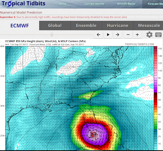
Computer Model Forecast Tracks Of Irma.
Valid At 8 AM EDT/6 AM MDT Sunday, Sept 10, 2017.
Valid At 8 AM EDT/6 AM MDT Sunday, Sept 10, 2017.
Valid At 8 AM EDT/6 AM MDT Sunday, Sept 10, 2017.
Valid At 2 AM EDT/Midnight MDT Saturday, Sept 9, 2017.
Valid At 11 PM EDT/9 PM MDT Saturday, Sept 9, 2017.
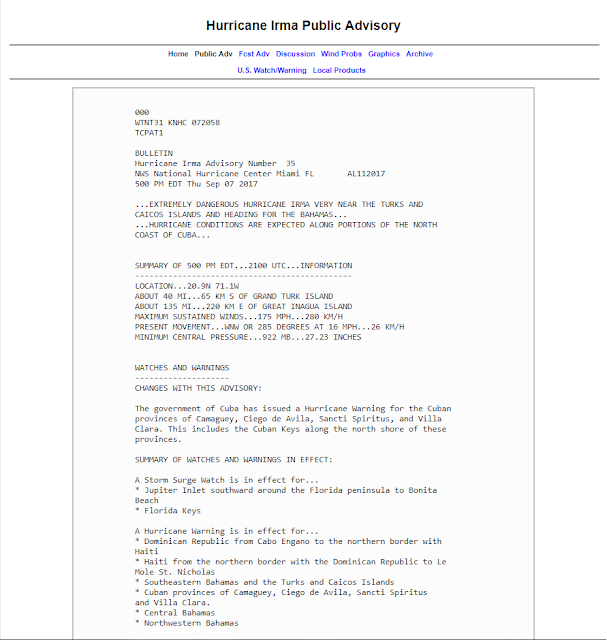
Remember that the computer forecast models shown above are not official forecasts. They disagree somewhat with each others timing on the arrival of Hurricane Irma in southern Florida. Having her arrival either late Saturday night or early Sunday morning. What we can take away from these graphics is that they all are forecasting a Major Hurricane making landfall in or close to the Miami area! Use these model forecasts with caution and only as a guide!
Again I want to stress that the probabilities of Hurricane Irma arriving in south Florida Saturday night or Sunday as a Major Hurricane are high! Should she move inland and roll over the top of the Miami area as a Category 4 or 5 Hurricane with sustained winds in the 111 to 157 mph range the damage will be catastrophic from these winds. Remember also that these are her forecast sustained winds. Her gusts may exceed 175 mph to 200 mph.
As local officials as well as local National Weather Service Offices including the National Hurricane Center are stressing constantly...do not get caught up paying too much attention to the exact forecast track of the Hurricane. Irma is a large Hurricane and her destructive winds will affect a wide area around the center of the eye. Her official track forecast may change between tonight and Sunday and afterwards. Keep up to date with the very latest information on Irma via the links highlighted above.
Florida Evacuates As Irma Approaches.
"We Can"t Save You Once This Storm Hits" says Florida's Governor Rick Scott. Some are panicking, many are leaving, and some are refusing to evacuate.
Traffic jams from people attempting to flee south Florida are bad and Gas Stations are running out of gas with 36% of the Miami-Fort Lauderdale Stations already out of fuel this Thursday afternoon. Gas shortages were also reported in the Tampa-St. Petersburg, Fort Myers-Naples, Gainsville, and West Palm Beach areas.
More than 650,000 coastal residents ordered to leave ahead of the Hurricane in Miami-Dade Counties alone.
Irma has the potential to be as bad if not worse than Category 5 Hurricane Andrew that struck south Miami and the Homesterad areas on August 24, 1992.
Hurricane Andrew
| Category 5 major hurricane (SSHWS/NWS) | |

Hurricane Andrew at peak intensity over the Bahamas on August 23
| |
| Formed | August 16, 1992 |
|---|---|
| Dissipated | August 28, 1992 |
| Highest winds | 1-minute sustained:175 mph (280 km/h) |
| Lowest pressure | 922 mbar (hPa); 27.23 inHg |
| Fatalities | 65 total |
| Damage | $26.5 billion (1992 USD) (Sixth-costliest tropical cyclone in the Atlantic basin; fifth-costliest inU.S. history) |
| Areas affected | The Bahamas; South Florida, Louisiana, and other areas of the Southern United States |
| Part of the 1992 Atlantic hurricane season | |
Hurricane Andrew was a Category 5 Atlantic hurricane that struck the Bahamas and Florida in mid-August 1992, the most destructive hurricane to ever hit the state. It was the strongest in decades and the costliest hurricaneto make landfall anywhere in the United States until it was surpassed by Katrina in 2005. Andrew caused major damage in the Bahamas and Louisiana, but the greatest impact was felt in South Florida, with sustained wind speeds as high as 165 mph (270 km/h). Passing directly through the city of Homestead in Dade County (now known as Miami-Dade County), it stripped many homes of all but their concrete foundations. In total, it destroyed more than 63,500 houses, damaged more than 124,000 others, caused $26.5 billion in damages,[nb 1] and left 65 people dead.
Andrew began as a tropical depression over the eastern Atlantic Ocean on August 16. After spending a week without significantly strengthening itself in the central Atlantic, it rapidly intensified into a powerful Category 5 hurricane while moving westward towards the Bahamas on August 23. Though it briefly weakened to Category 4 while traversing the Bahamas, it regained its Category 5 status before making landfall in Florida on Elliott Keyand Homestead on August 24. With a barometric pressure of 922 mbar (27.23 inHg) at the time of landfall in Florida, Andrew is the fourth most intense hurricane to strike the United States. Several hours later, the hurricane emerged over the Gulf of Mexico at Category 4 strength, with the Gulf Coast of the United States in its path. After turning northwestward and weakening further, Andrew moved ashore near Morgan City, Louisiana, as a low-end Category 3 storm. After moving inland, the small hurricane curved northeastward and rapidly lost its intensity, merging with a frontal system over the southern Appalachian Mountains on August 28.
Hurricane Andrew first inflicted structural damage as it moved through the Bahamas, especially in Cat Cays, lashing the islands with storm surge, hurricane-force winds, and tornadoes. About 800 houses were destroyed in the archipelago, and there was substantial damage to the transport, water, sanitation, agriculture, and fishing sectors. Andrew left four dead and $250 million in damage throughout the Bahamas. In parts of southern Florida, Andrew produced severe winds; a wind gust of 177 mph (282 km/h) was observed at a house in Perrine. The cities of Florida City, Homestead, and Cutler Ridge received the brunt of the storm. As many as 1.4 million people lost power at the height of the storm. In the Everglades, 70,000 acres (280 km2) of trees were downed, while invasive Burmese pythons began inhabiting the region after a nearby facility housing them was destroyed. Rainfall in Florida was substantial, peaking at 13.98 inches (355 mm) in western Dade County. In Florida, Andrew killed 44 and left a record $25 billion in damage.
Prior to making landfall in Louisiana on August 26, Andrew caused extensive damage to oil platforms in the Gulf of Mexico, leading to $500 million in losses for oil companies. It produced hurricane-force winds along its path through Louisiana, damaging large stretches of power lines that left about 230,000 people without electricity. Over 80% of trees in the Atchafalaya River basin were downed, and the agriculture there was devastated. Throughout the basin and Bayou Lafourche, 187 million freshwater fish were killed in the hurricane. With 23,000 houses damaged, 985 others destroyed, and 1,951 mobile homes demolished, property losses in Louisiana exceeded $1.5 billion. The hurricane caused the deaths of 17 people in the state, 6 of whom drowned offshore. Andrew spawned at least 28 tornadoes along the Gulf Coast, especially in Alabama, Georgia, and Mississippi. In total, Andrew left 65 dead and caused $26.5 billion in damage. It is currently the fifth costliest Atlantic hurricane to hit the United States, behind only Katrina, Sandy (2012), Ike (2008), and Harvey (2017), as well as the sixth costliest Atlantic hurricane, behind the aforementioned systems and Wilma (2005).
The Truth Is Stranger Than Fiction!









Comments
Post a Comment
Your comments, questions, and feedback on this post/web page are welcome.