Indian Summer Weather Continues.

Captured At 6:37 AM MDT This Morning.
This false color satellite image shows lots of low clouds and fog (depicted by the light blue shading) covering parts of south and central Texas early this morning. In fact the fog extends as far north as the Midland/Odessa area where their latest observation at 7:53 AM CDT/6:53 AM MDT indicates that their visibility was 1/4 of a mile and the sky was obscured with a vertical height into the fog of just 100 feet.
In contrast mid and high level clouds (depicted by the gray shades) are overspreading New Mexico and other parts of West Texas from the southwest.
At 6:51 AM MDT this morning the El Paso Airport was reporting scattered clouds at 17,000 feet above the ground with a broken deck of cirrus clouds at 25,000 feet. The Albuquerque Airport was reporting scattered clouds at 15,000 feet above the ground and an overcast cirrus deck at 20,000 feet. The Lubbock Airport was reporting a scattered deck of cirrus at 22,000 feet above the ground with a broken layer at 25,000 feet. To our west the Phoenix Airport was reporting a few clouds at 9,000 feet above the ground, scattered clouds at 14,000 feet, and a broken layer at 17,000.
Our November Indian Summer Heat Wave Continues.
Today.


Sunday.


Monday.


Indian Summer weather has taken hold of the area with above normal temperatures since our first freeze of the season last week. This trend is forecast to continue overall for the next week to ten days. With our high temps locally forecast to range from 80ºF to 85ºF today into Tuesday these readings will be some 10 to 15 degrees above normal for the date.
Windy This Weekend.

Higher gusts will be possible.

Next Cold Front Arrives Tuesday.

Valid At 5 PM MDT Wednesday.
ECMWF 500 MB (18,000') Forecast.

Valid At 5 PM MDT Wednesday.
Blame our fall warmth on the basically zonal flow at the mid and upper levels of the atmosphere. Until a decent storm can break through the riding south of Alaska and dive into the Desert Southwest not much change is forecast by the models for the next week to ten days. A short wave trough of low pressure will swing eastward across northern Colorado Tuesday. This will drive a cold front south into the area by Tuesday night.
Tuesday.

Forecast High Temperature Anomalies For Tuesday.

Wednesday.
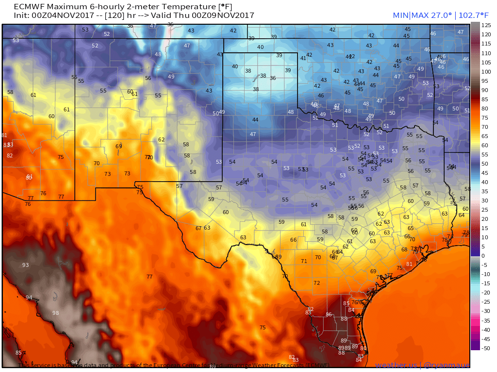

Above normal temperatures will briefly come to an end Wednesday behind a southward moving back door cold front that will enter the local area Tuesday afternoon and evening. After seeing highs in the 80's Wednesday's highs will likely only be in the 50's. Highs on Wednesday will be some 15ºF to 20ºF below normal on Wednesday. Therefore our temperature roller coaster ride continues.
Normal High/Low & Record High Temperatures For November 4th.
Roswell 69/339 Record High 86 1988
Artesia 71/36 Record High 90 1916
Carlsbad 71/40 Record High 90 1916
Hobbs 71/43 Record High 83 1949
Ruidoso 60/26 Record High 74 1949 (1941-2014)
Cloudcroft 54/28 Record High 63 1949


Last nights run of the European (ECMWF) forecast model breaks out a few pockets of light rain Tuesday night into Wednesday morning behind the cold front in the moist easterly upslope flow. I suspect that this will be mostly light drizzle and low clouds and if it does rain it won't be much.


Snow may fall across the higher elevations of the northern Mountains of the state. The highest totals will likely be along and close to the Colorado border.
Carlsbad, New Mexico.

Ruidoso, New Mexico.

A long time ago I learned that what goes up (in the weather world) will come back down. Its just a matter of when. Even though we have had a fairly mild and tranquil start to our fall with above normal temperatures I don't expect this to last. There are indications in the long range models and model teleconnections that changes will be coming by the last week or so of the month. A turn to colder weather with stormier conditions appear in the making.
(November 4th).

The Truth Is Stranger Than Fiction!


Comments
Post a Comment
Your comments, questions, and feedback on this post/web page are welcome.