First Winter Storm Of The 2017 - 2018 Season.
Quick update on me:
On November 15th I had surgery to have cancer removed from my small intestine. The doctors removed part of my small intestine and took out half of my stomach. I'm home and in recovery after spending 8 days in the Lubbock, Texas UMC Hospital. Recovery has been slow and hard. I've been suffering through bouts of dehydration and vomiting while my system recovers and re-adjusts. I had to relearn how to sleep again, and that up until a few days ago was in stints of a couple of hours at a time. But overall I'm healing although I'm sore and exhausted. I nap a lot which is a good thing.
On November 15th I had surgery to have cancer removed from my small intestine. The doctors removed part of my small intestine and took out half of my stomach. I'm home and in recovery after spending 8 days in the Lubbock, Texas UMC Hospital. Recovery has been slow and hard. I've been suffering through bouts of dehydration and vomiting while my system recovers and re-adjusts. I had to relearn how to sleep again, and that up until a few days ago was in stints of a couple of hours at a time. But overall I'm healing although I'm sore and exhausted. I nap a lot which is a good thing.
I thank God for his love and mercy through all of this. My wife has been my godsend and I simply could not have done this without her. She has wore herself out taking care of me. I would also like to thank my family and many friends for their prayers, love , and support. Without doubt his is one of the hardest things I've ever gone through. My prognosis is good. The doctors caught the cancer early and it was in Stage 1. No indications that I will need Chemotherapy or Radiation treatment. The cancer should not reoccur.
Snowing In The High Country.
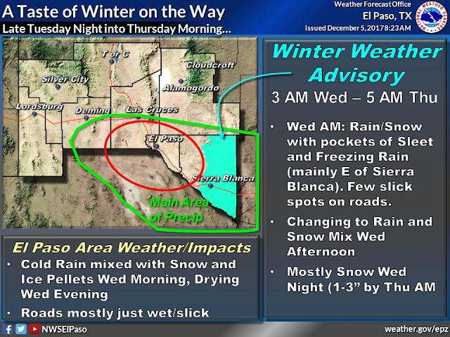
Looking at their web cam it appears that Ski Apache has had an inch or so of snow today. NWS forecasts for the ski resort that they may end up with 3" to 6" out of this storm by Thursday. Ruidoso may pick up a couple of inches out of the storm as may Cloudcroft.
First Winter Storm Of The Season.
A strong cold front raced south through the area overnight and high temperatures today behind the front have been mostly in the 40's. A small area of low pressure at the mid levels of the atmosphere is trying to close off over southern California. This little storm will provide the lift and energy to produce our first bout of wintry weather locally tonight into Thursday.
This after one of the warmest if not warmest Novembers on record in New Mexico and nearby areas. Remember my old standby...what goes up, comes down, eventually. Just a matter of figuring out when. Long range forecasts indicate that December could end up swinging the other way and become cold and snowy. Some indications that this December in New Mexico (Eastern half anyway) could be as cold as December 1989. There are some indications that this may be coldest winter east of the Rockies since 2,000. Time will tell.
ECMWF 500 MB Forecast.
Valid At Thursday At 5 PM MST.
Colder air over the area will get reinforced Wednesday and Thursday as a deep cold mid level trough of low pressure stretches southwestward from the Great Lakes back into southern Arizona.
Thick Mid Level Clouds Overspreading The Area.
A thick band of mid and high level clouds has overspread the region today. Looking at local ASOS?AWOS observations cloud bases have been running from around 12,000' layered up through 20,000' today. The low levels of the atmosphere are very dry locally with temps in the 40's and dew point temperatures in the teens. So the atmosphere will have to undergo top down moistening tonight into Wednesday in order for the precipitation that is aloft over the area to reach the surface. Radar has shown a mix of rain and snow overhead at times across the southern and southeastern parts of New Mexico today but this has been mostly aloft and virga. Low level upslope flow from the east and southeast will increase later tonight and this will help to "wet up or moisten the low levels" and aide in the development of rain, sleet, and snow.
Computer Model Forecast Snowfall/Rainfall Totals.
Valid At 11 AM MST Wednesday.
Valid At 11 AM MST Thursday.
Most of the models break out light rain over the area by sunset today and continue this trend overnight at the lower elevations. Light snow will fall across the higher elevations of the Guadalupe, Sacramento, and Capitan mountains.
This mornings run of the European model shows rain changing over to a mix of rain, freezing rain, and snow by around noontime Wednesday. All snow is forecast Wednesday night into Thursday.
Valid At 5 AM MST Wednesday.
The latest run of the GFS model (18Z) shows rain changing over to snow in the local area by sunrise Wednesday morning. I think we may see a wintry mix off and on late tonight into Wednesday morning with all snow by Wednesday afternoon.
How Much Snow?
Valid At 5 AM MST Friday.
ECMWF Storm Total Rainfall Forecast.
Valid At 5 AM MST Friday.
Valid At 5 AM MST Friday.
Valid At 5 AM MST Friday.
Canadian (GEM) Storm Total Snowfall Forecast.
Valid At 5 AM MST Friday.
It isn't often that I'm impressed with computer model snowfall forecasts for the area and this is one of those times I'm not. Overall the Canadian models (in my opinion for what that's worth) seem to have the best overall idea on coverage and perhaps storm totals. Either the models way over estimate our snowfall amounts or way under estimate them and I have the feeling this may be the case again. Anyway the main weather show should be late tonight or early tomorrow morning continuing into Thursday afternoon before the storm is forecast to move northeast of us and clear the area. As is usually the case any subtle change in the storm track and speed will alter and affect who get snow and how much. Surprises seem reasonable with this one.
The Truth Is Stranger Than Fiction!


Comments
Post a Comment
Your comments, questions, and feedback on this post/web page are welcome.