Continued Seasonably Hot - Best Chance For T-Storms Over The Mtns.
June 26th, 2019.
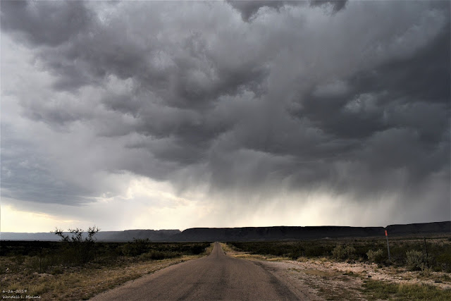
Looking West Towards Washington Ranch Southwest Of Carlsbad, NM.
High based thunderstorms are common in New Mexico in the spring and sometimes early summer. Meaning that these storms often have cloud bases that are some 10,000' to 15,000' above the surface. This occurs when the low levels of the atmosphere are relatively dry. The result is often light rainfall if it manages to fall to the ground. If not then you see a lot of virga as in my photo above. Virga is precipitation streaks that falls from the clouds but evaporates before it reaches the ground. Virga is a common sight in New Mexico.
When Do The Summer Rains Begin?
Valid At Midnight Sunday, June 30th, 2019.
GFS 500 Millibar/18,000' MSL Winds Analysis.
Valid At Midnight Sunday, June 30th, 2019.
Last nights upper air soundings and analysis shows a ridge of high pressure at the mid and upper levels of the atmosphere camped out over the area. Winds aloft at around the 18,000' level are mostly out of the northeast over Southeastern New Mexico. With strong subsidence (sinking air) occurring under the ridge these winds are not steering any storms into our local area because there are any to do so anyway.
A weak easterly wave is show moving westward in the Houston, Texas area. How far west or northwest this wave makes it this week will play a role in how much and where any summertime thunderstorms develop over the area.
Weather Prediction Center Total Rainfall Forecast.
Valid Today Through Next Sunday, July 7, 2019.
Current model forecasts aren't all that excited about a significant pattern change anytime soon. Typically our annual Monsoon kicks in around the 4th of July. Most of the models develop widely scattered to scattered thunderstorms later this week over the Sacramento mountains as well as the northern mountains and northeastern plains of the state. The rest of us locally will likely fall into the hit but mostly miss category.
I'm not so sure that I agree with last nights run of the GFS model concerning the heavier rainfall forecast to over the area. This seems overdue to me.
The Truth Is Stranger Than Fiction - And Sometimes It Hurts!





Comments
Post a Comment
Your comments, questions, and feedback on this post/web page are welcome.