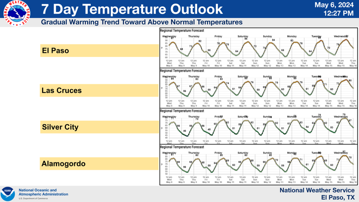
Changes Coming Late This Weekend Into Next Week- Cooler & Wetter!

Valid At 6 PM MDT Monday, Sept 9th, 2019.
Computer forecast models are coming together a little more concerning their forecasts with our upcoming pattern change this weekend into next week. Of course the GFS is still wetter overall as far as rainfall forecasts are concerned.
Overall a western trough of low pressure is still on track to dive into the central Rockies late this weekend into early next week. As this happens the flow aloft will become southwesterly which will aide in pulling the remnant moisture from former Tropical Storm Fernand northward into New Mexico and nearby areas.


Valid At 3:11 AM MDT This Thursday Morning.
How Much Rain Will Fall This Weekend Into Next Week?
GFS Storm Total Rainfall Forecast.

Valid By 6 PM MDT Monday, Sept 9th, 2019.
WPC 7-Day Storm Total Rainfall Forecast.

Valid Today Through Next Thursday, Sept 12th.


Its early in the game but the trend towards wetter and much cooler temperatures appears to be on track beginning this weekend and counting into next week. How much rain falls over the next week will be determined by just how far south the western trough of low pressure digs and when it pulls eastward into the central plains states.
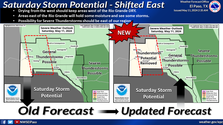
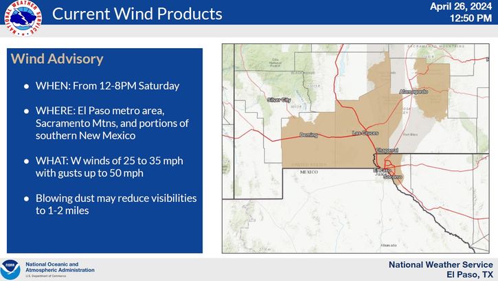
Another concern will be the potential for severe weather to return to the area. We have entered our second severe weather season which often can be more active than in the spring. September is known locally for producing some monster supercell thunderstorms. These have had a history of producing very large hail (softball size), torrential rainfall, and flash flooding.
Remnant moisture from dying Hurricanes in the Gulf of Mexico and the Eastern Pacific are notorious for helping produce widespread destructive flash flooding. Some locals have received nearly a years worth of their average rainfall in September alone in the past.
Check out some of my blog posts concerning local flash flood events by going to my main blog page http://www.senewmexicowx.org/. Scroll down the left hand side of the page until you see the header "Local Flash Floods" and click on one of the event dates. Photos and videos are included in these blog posts.
I currently don't seen anything in the model forecasts to indicate any widespread flash flooding. However its always prudent this time of the year to be aware of that potential.
I currently don't seen anything in the model forecasts to indicate any widespread flash flooding. However its always prudent this time of the year to be aware of that potential.
Southeastern Plains.


South-Central Mountains.


Southern New Mexico.


NHC Forecast Track Of Hurricane Dorian.

At 6 AM MDT Major Hurricane (Category 3) Dorian was located 70 miles south-southeast of Charleston, South Carolina moving to the north-northeast at 8 mph. Dorian had sustained winds of 115 mph with gusts near 140 mph. His central pressure was 959 millibars or 28.32" of mercury.
The Truth Is Stranger Than Fiction - And Sometimes It Hurts!


Comments
Post a Comment
Your comments, questions, and feedback on this post/web page are welcome.