Turning Colder Tonight Into Sunday. Beautiful Weather For Thanksgiving.
(At 1:30 PM MST Saturday Afternoon).
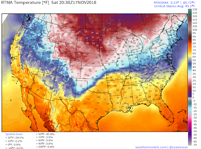
RTMA Temps & Wind Chills.
(At 1:30 PM MST Saturday Afternoon).
(At 2 PM MST Saturday Afternoon).
Regional Wind Chill Temps.
(At 2 PM MST Saturday Afternoon).
(At 11 AM MST Saturday Afternoon).
What a beautiful Saturday afternoon unless of course you are in not in Southeastern New Mexico where it is a pleasant 61º at 2:25 PM. A strong cold front has oozed into the local area as of 2 PM with the coldest air back to our north and northeast lagging behind the frontal boundary. Amarillo was reporting 30º with a wind chill of 17º. Clovis was reporting 37º with a wind chill of 28º. El Paso was reporting 70º.
One year ago today Roswell set a new daily record high temperature for November 17th with a reading of 89º. On November 6th, 1894 they set their all-time record high for November with a reading of 94º. Contrast this with the record low for November 17th of 8º in 2014.
NWS NDFD Forecast High Temp Anomalies.
High temperatures on Sunday will be some 20º below normal for the date with most locations east of the mountains seeing highs only in the 40's.
NWS NDFD Forecast High Temp Anomalies.
(Thanksgiving Day).
Thanksgiving Outlook.
Our weather for Thanksgiving this year will be quiet with seasonal temperatures. A fast moving disturbance may produce a few scattered light rain showers over the local area Tuesday night as it zips by overhead. But it won't be anything to write home about if in fact it does occur.
Our next best chance for a winter storm appears to be coming down the road in about a week from now. The European model digs a strong short wave trough of low pressure into the region and briefly closes it off around Sunday, November 25th. As is usually the case this is still eight days away so expect to see changes in the model forecasts between now and the next upcoming holiday weekend.
The Truth Is Stranger Than Fiction - And Sometimes It Hurts!


Comments
Post a Comment
Your comments, questions, and feedback on this post/web page are welcome.