My Current Weather

Sunday, August 30, 2020

Countdown To Fall Weather Underway.

What A Crazy Year This Has Been So Far.


Valid At Noon MDT Tuesday, September 1, 2020.


Valid At Noon MDT Tuesday, September 1, 2020.

Changes Blowin In The Wind.

That heading is literal as the Jet Stream is starting to get active once again. Computer models forecast a mid and upper-level trough of low pressure to dive southeastward out of the Pacific Northwest and into the Four Corners area by Tuesday. The GFS wants to open up a closed low and move it across the state. The European and Canadian models drop it further back to the west into Arizona and stall it. Either way, our chances for cooler and wetter weather are going to increase the first to middle of the upcoming work week.

 As we head into the meteorological fall (begins Tuesday) the Jet Stream will increasingly become more active and dig further and further to the south. Eventually displacing the summer heat ridge that has baked us all summer. A change is underway...here comes fall. I'm not saying we are done with our 100º temps, but gradually with time, we will begin to cool down. 

The average high/low temperatures for August 30th:

Roswell is 90º/64º
Artesia 92º/61º
Hope 90º/62º
 Carlsbad 92º/65º
 Hobbs 91º/65º
 Ruidoso 78º/49º
 Cloudcroft 69º/45º
Mountain Park 79º/55º
Elk 80º/51º
Alamogordo 93º/60º


A weak cold front will dig southward into the local area Monday evening in conjunction with the approaching mid-upper level trough. This will knock our high temperatures back down into the low 90's to the mid 90's, for the most part, Monday into Wednesday. Highs in the mountains will range from the upper 70's to the low 80's in the Ruidoso and Mayhill areas, to the upper 60's to the mid 70's in the Cloudcroft and Sunspot areas. A second cold front is forecast to enter the area on Tuesday.


Today.


Monday.


Tuesday.


Notice the moring low temperatures that are forecast over the northern plains Tuesday morning, the 40's and 50's. And the 20's and 30's across the higher elevations of the Rockies. Cloudcroft has already dipped down to 42ºF for a low on the 18th of this month. So our nights have started the process of cooling off. Now to get our daytime high temperatures down into the upper 80's to low 90's instead of the low 100's. 


Valid Today Through 6 AM MDT Wednesday, Sept 2, 2020.

Hit and miss thunderstorms will dot the local landscape today into Wednesday. Our chances for measurable rainfall in the valley's and plains is around 20% to 30%. In the mountains, this increases to 30% to 50%. 


Valid At 6 PM MDT Monday, August 31, 2020.

Light snow is forecast to fall over parts of the northern Rockies. Generally only an inch or so or less. Not that unusual either, just another sign that summer's days are numbered.

The Truth Is Stranger Than Fiction!

Friday, August 28, 2020

First Look At Winter - Grand Solar Minimum Still Coming.


First Look At Winter.

     As I write this it is 105ºF in Carlsbad, New Mexico. This marks the 60th time this summer I've hit 100ºF or higher here at our home on my Davis Vantage Pro+ Wireless Home Weather Station. Even though we live in the arid high desert Southwest, enough already. This is the year it seems summer is never going to end.

     So how about something different, something to distract you from the heat and drought? Farmers Almanac has released it's 2020-2021 Winter Forecast. 

     Long-range forecasting has never been my cup of tea but I've always admired those who attempt this almost impossible feat. Given how hot and dry our summer has been don't be surprised if Mother Nature tries to swing the pendulum the other way (cold winter) to balance herself out. Remember: "What goes up - always comes down, it's just of when."

     "“Based on our time-tested weather formula, the forecast for the upcoming winter looks a lot different from last year, quite divided with some very intense cold snaps and snowfall,” states editor Peter Geiger, Philom."

     "In New Mexico, Texas, Oklahoma east into Arkansas, and Louisiana, Mother Nature will mix intervals of tranquil weather with occasional shots of cold and wintry precipitation but overall may seem to be a bit “temperamental.”

Valentina Zharkova on the Upcoming Grand Solar Minimum.


Sunspot number: 0
Updated 28 Aug 2020


Current Stretch: 7 days
2020 total: 163 days (68%)
2019 total: 281 days (77%)
2018 total: 221 days (61%)
2017 total: 104 days (28%)
2016 total: 32 days (9%)
2015 total: 0 days (0%)
2014 total: 1 day (<1%)
2013 total: 0 days (0%)
2012 total: 0 days (0%)
2011 total: 2 days (<1%)
2010 total: 51 days (14%)
2009 total: 260 days (71%)
2008 total: 268 days (73%)
2007 total: 152 days (42%)
2006 total: 70 days (19%)
Updated 28 Aug 2020


     In this editorial, I will demonstrate with newly discovered solar activity proxy-magnetic field that the Sun has entered into the modern Grand Solar Minimum (2020–2053) that will lead to a significant reduction of solar magnetic field and activity like during Maunder minimum leading to noticeable reduction of terrestrial temperature.

     Currently, the Sun has completed solar cycle 24 – the weakest cycle of the past 100+ years – and in 2020, has started cycle 25. During the periods of low solar activity, such as the modern grand solar minimum, the Sun will often be devoid of sunspots. This is what is observed now at the start of this minimum, because in 2020 the Sun has seen, in total, 115 spotless days (or 78%), meaning 2020 is on track to surpass the space-age record of 281 spotless days (or 77%) observed in 2019. However, the cycle 25 start is still slow in firing active regions and flares, so with every extra day/week/month that passes, the null in solar activity is extended marking a start of grand solar minimum. What are the consequences for Earth of this decrease of solar activity?

     Similarly to Maunder Minimum, as discussed above, the reduction of solar magnetic field will cause a decrease of solar irradiance by about 0.22% for a duration of three solar cycles (25–27) for the first modern grand minimum (2020–2053) and four solar cycles from the second modern grand minimum (2370–2415).

     This, in turn, can lead to a drop of the terrestrial temperature by up to 1.0°C from the current temperature during the next three cycles (25–27) of grand minimum 1. The largest temperature drops will be approaching during the local minima between cycles 25 − 26 and cycles 26–27 when the lowest solar activity level is achieved using the estimations in Figure 2 (bottom plot) and Figure 3. Therefore, the average temperature in the Northern hemisphere can be reduced by up to 1.0°C from the current temperature, which was increased by 1.4°C since Maunder minimum. This will result in the average temperature to become lower than the current one to be only 0.4°C higher than the temperature measured in 1710. Then, after the modern grand solar minimum 1 is over, the solar activity in cycle 28 will be restored to normal in the rather short but powerful grand solar cycle lasting between 2053 and 2370, as shown in Figure 3, before it approaches the next grand solar minimum 2 in 2370.    

Conclusions:

     In this editorial, I have demonstrated that the recent progress with understanding a role of the solar background magnetic field in defining solar activity and with quantifying the observed magnitudes of magnetic field at different times allowed us to enable reliable long-term prediction of solar activity on a millennium timescale. This approach revealed a presence of not only 11-year solar cycles but also of grand solar cycles with duration of 350–400 years. We demonstrated that these grand cycles are formed by the interferences of two magnetic waves with close but not equal frequencies produced by the double solar dynamo action at different depths of the solar interior. These grand cycles are always separated by grand solar minima of Maunder minimum type, which regularly occurred in the past forming well-known Maunder, Wolf, Oort, Homeric, and other grand minima.

     During these grand solar minima, there is a significant reduction of solar magnetic field and solar irradiance, which impose the reduction of terrestrial temperatures derived for these periods from the analysis of terrestrial biomass during the past 12,000 or more years. The most recent grand solar minimum occurred during Maunder Minimum (1645–1710), which led to reduction of solar irradiance by 0.22% from the modern one and a decrease of the average terrestrial temperature by 1.0–1.5°C.

     This discovery of double dynamo action in the Sun brought us a timely warning about the upcoming grand solar minimum 1, when solar magnetic field and its magnetic activity will be reduced by 70%. This period has started in the Sun in 2020 and will last until 2053. During this modern grand minimum, one would expect to see a reduction of the average terrestrial temperature by up to 1.0°C, especially, during the periods of solar minima between the cycles 25–26 and 26–27, e.g. in the decade 2031–2043.

     The reduction of a terrestrial temperature during the next 30 years can have important implications for different parts of the planet on growing vegetation, agriculture, food supplies, and heating needs in both Northern and Southern hemispheres. This global cooling during the upcoming grand solar minimum 1 (2020–2053) can offset for three decades any signs of global warming and would require inter-government efforts to tackle problems with heat and food supplies for the whole population of the Earth.

The Truth Is Stranger Than Fiction!

Tuesday, August 25, 2020

Hurricane Laura Update - Tuesday, August 25, 2020.


3:51 PM MDT Tuesday, August 25, 2020 - True Color Visible.

3:46 PM MDT Tuesday, August 25, 2020 - Visible/IR Combined (Sandwich).

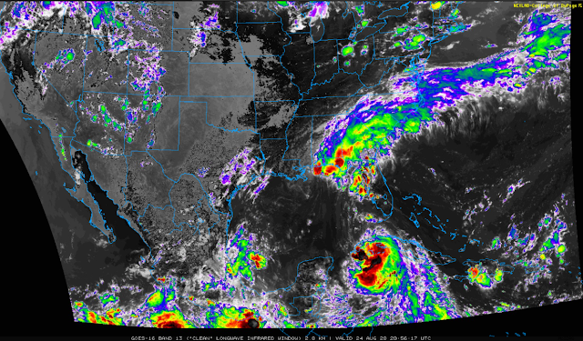
3:57 PM MDT Tuesday, August 25, 2020 - Clean (LWIR).

Forecast Tracks Of Hurricane Laura.


Computer Model Forecast Tracks Of Hurricane Laura.


     Incredible wave heights are forecast to peak around Wednesday afternoon offshore southeast of Houston, Texas. How about 75 feet according to the ECMWF model.


Hurricane Laura To Become A Major Hurricane Before Landfall.

     As of 4:30 PM MDT this afternoon Hurricane Laura continues to churn west-northwestward at 17 mph across the open Gulf of Mexico headed for a Texas landfall. The latest forecasts from the National Hurricane Center call for Laura to make landfall late Wednesday night or early Thursday morning. The exact track where she makes landfall still is not settled amongst the models.

     Laura could still make landfall west of the Houston area or between Lake Charles and Lafayette. For now (as of this writing Tuesday afternoon) the NHC is calling for Laura to make landfall near Sabine Pass, south of Port Arthur, Texas 75 miles east of Houston. This could change and likely will change so don't bet on this exact position. 

     Hurricane Laura is forecast to become a Major Hurricane on Wednesday before she makes landfall as she moves over very warm waters. Wind shear is forecast to be minimal until roughly the last 6-12 hours before landfall when southwesterly wind shear will affect the Hurricane. Rapid strengthening is still forecast on Wednesday. Current thinking is that Laura will become a Category 3 or possibly a Category 4 Hurricane.

     Very heavy rainfall is forecast as Hurricane Laura moves inland and dissipates. 10" to 15" is what is forecast for now. Any changes in track and speed could change this. It's not uncommon for Major Hurricanes to produce over 20+ inches of rain. Devastating flooding and flash flooding will occur in her path.

Saffir-Simpson Hurricane Wind Scale


The Saffir-Simpson Hurricane Wind Scale is a 1 to 5 rating based on a hurricane's sustained wind speed. This scale estimates potential property damage. Hurricanes reaching Category 3 and higher are considered major hurricanes because of their potential for significant loss of life and damage. Category 1 and 2 storms are still dangerous, however, and require preventative measures. In the western North Pacific, the term "super typhoon" is used for tropical cyclones with sustained winds exceeding 150 mph. Note that all winds are using the U.S. 1-minute average.

Category One Hurricane

     Winds 74-95 mph (64-82 kt or 119-153 km/hr). Very dangerous winds will produce some damage: Well-constructed frame homes could have damage to roof, shingles, vinyl siding and gutters. Large branches of trees will snap and shallowly rooted trees may be toppled. Extensive damage to power lines and poles likely will result in power outages that could last a few to several days. Irene of 1999, Katrina of 2005, and several others were Category One hurricanes at landfall in South Florida.


Category Two Hurricane

     Winds 96-110 mph (83-95 kt or 154-177 km/hr). Extremely dangerous winds will cause extensive damage: Well-constructed frame homes could sustain major roof and siding damage. Many shallowly rooted trees will be snapped or uprooted and block numerous roads. Near-total power loss is expected with outages that could last from several days to weeks. Frances of 2004 was a Category Two when it hit just north of Palm Beach County, along with at least 10 other hurricanes which have struck South Florida since 1894.


Category Three Hurricane

    Winds 111-129 mph (96-112 kt or 178-208 km/hr). Devastating damage will occur: Well-built framed homes may incur major damage or removal of roof decking and gable ends. Many trees will be snapped or uprooted, blocking numerous roads. Electricity and water will be unavailable for several days to weeks after the storm passes. Unnamed hurricanes of 1909, 1910, 1929, 1933, 1945, and 1949 were all Category 3 storms when they struck South Florida, as were King of 1950, Betsy of 1965, Jeanne of 2004, and Irma of 2017.


Category Four Hurricane

     Winds 130-156 mph (113-136 kt or 209-251 km/hr). Catastrophic damage will occur: Well-built framed homes can sustain severe damage with loss of most of the roof structure and/or some exterior walls. Most trees will be snapped or uprooted and power poles downed. Fallen trees and power poles will isolate residential areas. Power outages will last weeks to possibly months. Most of the area will be uninhabitable for weeks or months. The 1888, 1900, 1919, 1926 Great Miami, 1928 Lake Okeechobee/Palm Beach, 1947, Donna of 1960 made landfall in South Florida as Category Four hurricanes.


Category Five Hurricane

     Winds 157 mph or higher (137 kt or higher or 252 km/hr or higher). Catastrophic damage will occur: A high percentage of framed homes will be destroyed, with total roof failure and wall collapse. Fallen trees and power poles will isolate residential areas. Power outages will last for weeks to possibly months. Most of the area will be uninhabitable for weeks or months. The Keys Hurricane of 1935 and Andrew of 1992 made landfall in South Florida as Category Five hurricanes.


BULLETIN
Hurricane Laura Advisory Number  24
NWS National Hurricane Center Miami FL       AL132020
400 PM CDT Tue Aug 25 2020

...LAURA MOVING WEST-NORTHWESTWARD ACROSS THE CENTRAL GULF OF
MEXICO...
...EXPECTED TO STRENGTHEN INTO A MAJOR HURRICANE BEFORE LANDFALL 
WEDNESDAY NIGHT OR THURSDAY MORNING...


SUMMARY OF 400 PM CDT...2100 UTC...INFORMATION
----------------------------------------------
LOCATION...24.7N 88.3W
ABOUT 480 MI...770 KM SE OF LAKE CHARLES LOUISIANA
ABOUT 510 MI...820 KM SE OF GALVESTON TEXAS
MAXIMUM SUSTAINED WINDS...80 MPH...130 KM/H
PRESENT MOVEMENT...WNW OR 300 DEGREES AT 17 MPH...28 KM/H
MINIMUM CENTRAL PRESSURE...990 MB...29.24 INCHES


WATCHES AND WARNINGS
--------------------
CHANGES WITH THIS ADVISORY:

None.

SUMMARY OF WATCHES AND WARNINGS IN EFFECT:

A Storm Surge Warning is in effect for...
* San Luis Pass Texas to the Mouth of the Mississippi River

A Hurricane Warning is in effect for...
* San Luis Pass Texas to Intracoastal City Louisiana

A Tropical Storm Warning is in effect for...
* Sargent Texas to San Luis Pass
* East of Intracoastal City Louisiana to the Mouth of the
Mississippi River

A Storm Surge Watch is in effect for...
* Freeport Texas to San Luis Pass
* Mouth of the Mississippi River to Ocean Springs Mississippi
* Lake Pontchartrain, Lake Maurepas, and Lake Borgne

A Hurricane Watch is in effect for...
* East of Intracoastal City to west of Morgan City Louisiana

A Storm Surge Warning means there is a danger of life-threatening
inundation, from rising water moving inland from the coastline,
during the next 36 hours in the indicated locations. For a
depiction of areas at risk, please see the National Weather
Service Storm Surge Watch/Warning Graphic, available at
hurricanes.gov.  This is a life-threatening situation.  Persons
located within these areas should take all necessary actions to
protect life and property from rising water and the potential for
other dangerous conditions.  Promptly follow evacuation and other
instructions from local officials.

A Hurricane Warning means that hurricane conditions are expected
somewhere within the warning area.  A warning is typically issued
36 hours before the anticipated first occurrence of
tropical-storm-force winds, conditions that make outside
preparations difficult or dangerous.  Preparations to protect life
and property should be rushed to completion.

A Storm Surge Watch means there is a possibility of life-
threatening inundation, from rising water moving inland from the
coastline, in the indicated locations during the next 48 hours.

A Hurricane Watch means that hurricane conditions are possible
within the watch area.  A watch is typically issued 48 hours
before the anticipated first occurrence of tropical-storm-force
winds, conditions that make outside preparations difficult or
dangerous.

A Tropical Storm Warning means that tropical storm conditions are
expected somewhere within the warning area.

For storm information specific to your area, including possible
inland watches and warnings, please monitor products issued by your
local National Weather Service forecast office.


DISCUSSION AND OUTLOOK
----------------------
At 400 PM CDT (2100 UTC), the center of Hurricane Laura was located
near latitude 24.7 North, longitude 88.3 West. Laura is moving
toward the west-northwest near 17 mph (28 km/h), and this general
motion should continue tonight. A turn toward the northwest is
forecast by Wednesday, and a northwestward to north-northwestward
motion should continue through Wednesday night.  On the forecast
track, the center of Laura will move across the central Gulf of
Mexico tonight and the northwestern Gulf of Mexico on Wednesday.
The hurricane should approach the Upper Texas and Southwest 
Louisiana coasts on Wednesday night and move inland near those 
areas late Wednesday night or Thursday morning.

Maximum sustained winds are near 80 mph (130 km/h) with higher
gusts.  Significant strengthening is forecast during the next 36
hours, and Laura is expected to be a major hurricane at landfall.
Rapid weakening is expected after Laura makes landfall.

Hurricane-force winds extend outward up to 45 miles (75 km) from the
center and tropical-storm-force winds extend outward up to 175 miles
(280 km).

The estimated minimum central pressure is 990 mb (29.24 inches).


HAZARDS AFFECTING LAND
----------------------
Key messages for Laura can be found in the Tropical Cyclone
Discussion under AWIPS header MIATCDAT3 and WMO header WTNT43 KNHC.

STORM SURGE:  The combination of a dangerous storm surge and the
tide will cause normally dry areas near the coast to be flooded by
rising waters moving inland from the shoreline.  The water could
reach the following heights above ground somewhere in the indicated
areas if the peak surge occurs at the time of high tide...

Sea Rim State Park TX to Intracoastal City LA including Sabine Lake
and Calcasieu Lake...9-13 ft
Intracoastal City to Morgan City including Vermilion Bay...7-11 ft
Port Bolivar TX to Sea Rim State Park...6-9 ft
Morgan City LA to Mouth of the Mississippi River...4-6 ft
San Luis Pass TX to Port Bolivar...3-5 ft
Galveston Bay...3-5 ft
Freeport TX to San Luis Pass...2-4 ft
Mouth of the Mississippi River to Ocean Springs MS including Lake
Borgne...2-4 ft
Lake Pontchartrain and Lake Maurepas...2-4 ft

The deepest water will occur along the immediate coast near and to 
the right of the landfall location, where the surge will be 
accompanied by large and destructive waves.  This storm surge could 
penetrate up to 30 miles inland from the immediate coastline in 
southwestern Louisiana and far southeastern Texas. 

Surge-related flooding depends on the relative timing of the surge 
and the tidal cycle, and can vary greatly over short distances.  For 
information specific to your area, please see products issued by 
your local National Weather Service forecast office.

RAINFALL:  From Wednesday afternoon through Friday, Laura is 
expected to produce rainfall totals of 5 to 10 inches, with isolated 
maximum amounts of 15 inches across portions of the northwestern 
Gulf Coast from western Louisiana to far eastern Texas, and 
northward into much of Arkansas. Over the Lower to Middle 
Mississippi Valley from central Louisiana into western Tennessee and 
Kentucky, and southeastern Missouri, 2 to 4 inches of rainfall with 
isolated totals of 6 inches are expected. This rainfall will cause 
widespread flash and urban flooding, small streams to overflow their 
banks, and minor to isolated moderate river flooding.

By late Friday into Saturday, portions of the Tennessee and Ohio 
Valley could see 2 to 4 inches with locally higher amounts as 
tropical moisture from Laura moves through the region.

WIND: Hurricane conditions are expected in the hurricane warning
area Wednesday night and Thursday.  Tropical storm conditions are
expected to reach the coast in the hurricane warning area late
Wednesday or Wednesday night, and are expected in the tropical
storm warning area Wednesday night and Thursday. 

Hurricane-force winds and damaging wind gusts are also expected to 
spread well inland into portions of eastern Texas and western 
Louisiana early Thursday. 

TORNADOES: A few tornadoes are expected Wednesday and Wednesday
night over Louisiana, southeast Texas, and southwestern Mississippi.

SURF:  Swells generated by Laura are affecting portions of Cuba, the
central Bahamas, and the Florida Keys. Swells are expected to spread
northward along portions of the west coast of Florida peninsula and
the coast of the Florida panhandle later today and tonight, and
reach the northern and northwest Gulf coast by Wednesday. These
swells are likely to cause life-threatening surf and rip current
conditions.  Please consult products from your local weather office.


NEXT ADVISORY
-------------
Next intermediate advisory at 700 PM CDT.
Next complete advisory at 1000 PM CDT.

$$
Forecaster Beven
Click On These Links Below For The Latest On Laura.


Louisiana National Weather Service Offices.


Texas National Weather Service Offices.


Local Statements are prepared by National Weather Service Weather Forecast Offices (WFO) giving specific details for their County Warning Area (CWA) on weather conditions, evacuation decisions made by local officials, and other precautions necessary to protect life and property.

On this page are links to the Local Statements that have been released within the last 8 hours, as well as links to the homepages of the issuing Weather Forecast Offices.

Issuing WFO HomepageLocal ImpactsLocal Statement
New Orleans / Baton Rouge, LAThreats and Impacts406 PM CDT Tue Aug 25
Houston / Galveston, TXThreats and Impacts418 PM CDT Tue Aug 25
Lake Charles, LAThreats and Impacts432 PM CDT Tue Aug 25
Shreveport, LAThreats and Impacts443 PM CDT Tue Aug 25

The Truth Is Stranger Than Fiction!

Monday, August 24, 2020

Tropical Storm Laura - Monday, August 24, 2020.


2:56 PM MDT Monday, August 24, 2020.

Tropical Storm Laura.
3:01 PM MDT Monday, August 24, 2020.


Tropical Storm Laura To Strengthen Tonight.


(Tonight Into Next Monday).


     Tropical Storm Laura was located near 21.7N and 82.2W or 40 miles east of the Ise of Youth as of 3 PM MDT or 4 PM CDT this Monday afternoon. She has sustained winds of 60 mph with gusts near 70 mph. Her central pressure remains fairly steady at 1001 millibars or 29.56 inches of mercury. Laura is moving steadily to the west-northwest at 20 mph.

      Tropical Storm Laura is forecast to begin steadily strengthening tonight as she pulls away from Cuba and enters the southeastern Gulf of Mexico. Rapid intensification is forecast by the Hurricane computer forecast models once Laura develops into a Hurricane. Especially tomorrow into Wednesday as she traverses the very warm waters of the Central Gulf of Mexico which are running near 85ºF to nearly 90ºF

     This morning's computer models had begun shifting Laura's track further to the west with the Hurricane forecast to make a bullseye hit on the Houston/Galveston area by early Thursday morning. This was consentient with the storm moving south of Cuba.

     This afternoon's official NHC forecast has her making landfall now predicted along the southwestern Louisiana Coast around 2 AM CDT Thursday morning. 

     Obviously, this poses problems with trying to figure out just exactly where Laura is going to make landfall and when. The window of opportunity timewise, for now, is sometime between Wednesday night and Thursday morning. This is still up in the air as is the exact track that she takes. Landfall somewhere as far west as the Houston area and as far east as the southern Coast of Louisana is still possible! It is highly likely that we won't know where she is likely to make landfall until tomorrow or tomorrow night.

     Forecasts by the computer models indicate that Tropical Storm Laura will intensify into a Hurricane later tonight. Then rapidly strengthen tomorrow into Wednesday as she moves generally northwestward across the Gulf. Laura may make landfall as a Major Hurricane...possibly as a Category 3-4!

     Storm total rainfall amounts from Laura are going to be excessive. Since the storm still hasn't obtained hurricane strength at the time of this writing I believe the models are way underestimating her rainfall as depicted above. Major Hurricanes typically dump 20+ inches of rain over the areas they impact and no doubt Laura has this potential. Severe flooding will be a concern inland from where she makes landfall.

     Should Laura track further west and make landfall in the Houston/Galveston, Texas area as some of the models continue to indicate then this would be a total disaster for those areas. Economically, socially, and health-wise with the ongoing effects of the COVID-19 Pandemic. The same would be true if it strikes the Beaumont, Texas, and the Lake Charles or New Orleans areas. No matter where she makes landfall this is going to be ugly!

Click On These Links Below For The Latest On Laura.


Louisiana National Weather Service Offices.


Texas National Weather Service Offices.


The Truth Is Stranger Than Fiction!

Sunday, August 23, 2020

Hurricane Marco - Tropical Laura & New Mexico Smoke.

(At 9:10 AM MDT Sunday, August 23, 2020).

Level 1:
In today's GOES-16 image, you can see the enhanced fire detection ability of the satellite. Check out the bright ares in the yellow circles. They depict heat from active wildfires. We use this a lot during our spring wildfire season here in West TX too #lubwx #scienceiscool

There's a lot of smoke floating around the stalled ridge of high pressure in the western United States. Also neat to see all the smoke being pulled in to the remnants of once Category 4 #HurricaneGenevieve near the Baja... #COwx #Smoke #HRRRSmoke #CAwx


     August 23, 2020

Currently, 93 large fires have burned more than 1.6 million acres in 13 states. More than 26,000 wildland firefighters and support personnel are assigned to incidents across the country. Evacuation orders are in effect for residents near 20 large fires in Arizona, California, Colorado, Oregon and Utah.

U.S. GFS 500 Millibar(18,000' MSL) Analysis.
(At 6 AM MDT Sunday, August 23, 2020).

Hazy-Smoky New Mexico Skies.

     Hazy, milky, smoky skies at sunrise this morning continue across New Mexico and nearby areas. Thanks to the numerous Western U.S. forest fires and wildfires that continue to burn. Currently, the northern two-thirds of New Mexico are under an Air Quality Alert because of these fires. Clockwise circulation around a strong mid-level (500 millibars or 18,000') high-pressure center which was located over the 4-Corners at sunrise this morning, continues to feed smoke south and southeastward into New Mexico from California and the rest of the Western U.S.

Rough Week Ahead For Louisana & Maybe Texas.

     Marco has strengthened to a Hurricane late this morning while Tropical Storm Laura is continuing to track slightly further south than model forecasts originally indicated. These won't be the only changes in status of these two Tropical Cyclones either. I expect to see more changes with both storms.

     It is of concern that the latest model guidance is tracking Laura further westward and closer to the Houston and Beaumont, Texas areas. Equally worrisome is that there is potential for Laura to become a Major Hurricane before making landfall the middle to end of next week somewhere along the Texas/Louisana Coastline. 

     Marco's increase in strength to Hurricane status this morning gives concern for southern Louisana on Monday also. 

Hurricane Marco.

(At 10:47 AM MDT Sunday, August 23, 20020).

Hurricane Marco Longwave IR (2 KM) Satellite Image.
(At 10:52 AM MDT Sunday, August 23, 2020).


(Click On The Link For The Very Latest Updates).
Hurricane Marco Tropical Cyclone Update
NWS National Hurricane Center Miami FL       AL142020
1130 AM CDT Sun Aug 23 2020

...MARCO BECOMES A HURRICANE...
...LIFE-THREATENING STORM SURGE AND HURRICANE-FORCE WINDS EXPECTED 
ALONG PORTIONS OF THE U.S. GULF COAST...

Data from an Air Force Reserve Hurricane Hunter aircraft indicate 
that Marco has strengthened into a hurricane with maximum winds of 
75 mph (120 km/h) with higher gusts.


SUMMARY OF 1130 AM CDT...1630 UTC...INFORMATION
----------------------------------------------
LOCATION...25.0N 87.4W
ABOUT 300 MI...480 KM SSE OF THE MOUTH OF THE MISSISSIPPI RIVER
ABOUT 460 MI...740 KM SE OF LAFAYETTE LOUISIANA
MAXIMUM SUSTAINED WINDS...75 MPH...120 KM/H
PRESENT MOVEMENT...NNW OR 340 DEGREES AT 14 MPH...22 KM/H
MINIMUM CENTRAL PRESSURE...992 MB...29.29 INCHES

$$
Forecaster Latto
---------------------------------------------------------------------------------------------
BULLETIN
Tropical Storm Marco Advisory Number  13
NWS National Hurricane Center Miami FL       AL142020
1000 AM CDT Sun Aug 23 2020

...MARCO EXPECTED TO BECOME A HURRICANE TODAY AS IT ENTERS
THE CENTRAL GULF OF MEXICO...
...LIFE-THREATENING STORM SURGE AND HURRICANE-FORCE WINDS EXPECTED 
ALONG PORTIONS OF THE U.S. GULF COAST...


SUMMARY OF 1000 AM CDT...1500 UTC...INFORMATION
-----------------------------------------------
LOCATION...24.7N 87.3W
ABOUT 325 MI...520 KM SSE OF THE MOUTH OF THE MISSISSIPPI RIVER
ABOUT 475 MI...765 KM SE OF LAFAYETTE LOUISIANA
MAXIMUM SUSTAINED WINDS...70 MPH...110 KM/H
PRESENT MOVEMENT...NNW OR 340 DEGREES AT 14 MPH...22 KM/H
MINIMUM CENTRAL PRESSURE...993 MB...29.33 INCHES


WATCHES AND WARNINGS
--------------------
CHANGES WITH THIS ADVISORY:

The Storm Surge Watch has been discontinued from the 
Mississippi/Alabama border to the Alabama/Florida border, including 
Mobile Bay. 

SUMMARY OF WATCHES AND WARNINGS IN EFFECT:

A Storm Surge Warning is in effect for....
* Morgan City Louisiana to Ocean Springs Mississippi
* Lake Borgne

A Hurricane Warning is in effect for...
* Morgan City Louisiana to the Mouth of the Pearl River

A Storm Surge Watch is in effect for...
* Sabine Pass to Morgan City Louisiana
* Ocean Springs Mississippi to the Mississippi/Alabama border
* Lake Pontchartrain and Lake Maurepas

A Hurricane Watch is in effect for...
* Intracoastal City Louisiana to west of Morgan City
* Lake Pontchartrain, Lake Maurepas, and Metropolitan New Orleans

A Tropical Storm Warning is in effect for...
* Mouth of the Pearl River to the Mississippi/Alabama border
* Lake Pontchartrain, Lake Maurepas, and Metropolitan New Orleans

A Tropical Storm Watch is in effect for...
* Mississippi/Alabama border to the Alabama/Florida border

A Storm Surge Warning means there is a danger of life-threatening
inundation, from rising water moving inland from the coastline,
during the next 36 hours in the indicated locations. For a
depiction of areas at risk, please see the National Weather
Service Storm Surge Watch/Warning Graphic, available at
hurricanes.gov.  This is a life-threatening situation.  Persons
located within these areas should take all necessary actions to
protect life and property from rising water and the potential for
other dangerous conditions.  Promptly follow evacuation and other
instructions from local officials.

A Hurricane Warning means that hurricane conditions are expected
somewhere within the warning area.  A warning is typically issued
36 hours before the anticipated first occurrence of
tropical-storm-force winds, conditions that make outside
preparations difficult or dangerous.  Preparations to protect life
and property should be rushed to completion.

A Storm Surge Watch means there is a possibility of life-
threatening inundation, from rising water moving inland from the
coastline, in the indicated locations during the next 48 hours.
For a depiction of areas at risk, please see the National Weather
Service Storm Surge Watch/Warning Graphic, available at
hurricanes.gov.

A Hurricane Watch means that hurricane conditions are possible
within the watch area.

A Tropical Storm Warning means that tropical storm conditions are
expected somewhere within the warning area within 36 hours.

A Tropical Storm Watch means that tropical storm conditions are
possible within the watch area, generally within 48 hours.

For storm information specific to your area in the United
States, including possible inland watches and warnings, please
monitor products issued by your local National Weather Service
forecast office. For storm information specific to your area
outside of the United States, please monitor products issued by
your national meteorological service.


DISCUSSION AND OUTLOOK
----------------------
At 1000 AM CDT (1500 UTC), the center of Tropical Storm Marco was 
located near latitude 24.7 North, longitude 87.3 West. Marco is 
moving toward the north-northwest near 14 mph (22 km/h), and this 
motion is expected to continue through tonight, followed by a turn 
to the northwest by Monday. On the forecast track, Marco will cross 
the central Gulf of Mexico today and will approach southeastern 
Louisiana on Monday. A gradual turn toward the west-northwest with 
a decrease in forward speed is expected after Marco moves inland.

Maximum sustained winds are near 70 mph (110 km/h) with higher
gusts.  Some strengthening is anticipated and Marco is forecast to
become a hurricane later today and be at hurricane strength when it
approaches the northern Gulf Coast on Monday. Rapid weakening is
expected after Marco moves inland.

Tropical-storm-force winds extend outward up to 70 miles (110 km)
from the center.

The estimated minimum central pressure is 993 mb (29.33 inches).


HAZARDS AFFECTING LAND
----------------------
STORM SURGE:  The combination of a dangerous storm surge and the
tide will cause normally dry areas near the coast to be flooded by
rising waters moving inland from the shoreline.  The water could
reach the following heights above ground somewhere in the indicated
areas if the peak surge occurs at the time of high tide...

Morgan City LA to Ocean Springs MS including Lake Borgne...4-6 ft
Sabine Pass to Morgan City LA...2-4 ft
Ocean Springs MS to the MS/AL Border...2-4 ft
Lake Pontchartrain and Lake Maurepas...2-4 ft
MS/AL Border to AL/FL Border including Mobile Bay...1-3 ft

The deepest water will occur along the immediate coast in areas of
onshore winds, where the surge will be accompanied by large and
dangerous waves.  Surge-related flooding depends on the relative
timing of the surge and the tidal cycle, and can vary greatly over
short distances.  For information specific to your area, please see
products issued by your local National Weather Service forecast
office.

WIND:  Hurricane conditions are expected within the hurricane
warning area by midday Monday, with tropical storm conditions
possible by early Monday. Tropical storm conditions are possible
within the tropical storm watch area on Monday, and hurricane
conditions are possible within the hurricane watch areas late
Monday.

RAINFALL: Marco is expected to produce rainfall accumulations of 2
to 4 inches with isolated maximum amounts of 6 inches across the
Central U.S. Gulf coast through Tuesday.

This rainfall may result in isolated areas of flash and urban
flooding along the Central U.S. Gulf Coast.

SURF: Swells generated by Marco are likely to affect portions of
the northern Gulf Coast later today. These swells are likely to
cause life-threatening surf and rip current conditions.  Please
consult products from your local weather office.

TORNADOES: An isolated tornado will be possible early Monday morning
near the southeast Louisiana coast.


NEXT ADVISORY
-------------
Next intermediate advisory at 100 PM CDT.
Next complete advisory at 400 PM CDT.

$$
Forecaster Latto
-----------------------------------------------------------------
Forecast Discussion.
(Click On The Link For The Very Latest Updates).
Tropical Storm Marco Discussion Number  13
NWS National Hurricane Center Miami FL       AL142020
1000 AM CDT Sun Aug 23 2020

Deep convection with cloud tops of -75 to -80 degrees C has 
persisted over the center of Marco for the past several hours. An 
Air Force Reserve Hurricane Hunter aircraft currently investigating 
the cyclone measured winds equivalent to 62 kt both with the SFMR 
and in a dropsonde in the northeastern eyewall. However, the 
aircraft reported peak 850-mb flight level winds of only 64 kt. 
Based on a blend of these data it appears that Marco is on the cusp 
of becoming a hurricane, but is not quite there yet. Therefore, the 
initial intensity remains 60 kt.

Based on the SHIPS guidance, Marco has about a 12-24 hour window to 
intensify in an environment characterized by moderate southwesterly 
shear, very warm waters, and plenty of atmospheric moisture. After 
that time, the vertical wind shear is expected to increase and this 
should begin to dominate the cyclone's environment. The latest NHC 
intensity forecast is unchanged from the previous one, forecasting 
Marco to become a hurricane later today, and maintaining hurricane 
intensity up until landfall in agreement with the latest LGEM 
intensity guidance. While it is possible that Marco will weaken just 
prior to landfall due to the increasing shear, there is little 
difference in the impacts between a 60 and 65 kt system. 

Marco is moving north-northwestward or 340/12 kt. Although the 
overall guidance has not changed much since the previous advisory, 
there remains considerable spread in this guidance by the time Marco 
reaches the northern Gulf coast. This spread could be attributed to 
the varying ways the models handle the system as it encounters the 
more hostile environment near the coast. Since the track consensus 
aids have changed little through 36 h, the official forecast is 
essentially the same as the previous one through that time. The 
model guidance has shifted a little northward beyond 36 h, so the 
official forecast was nudged to the north during that time as well. 

Key Messages:

1. Hurricane conditions, life-threatening storm surge, and heavy
rainfall are expected from Marco along portions of the Gulf Coast
beginning on Monday, and Hurricane and Storm Surge Warnings have
been issued. Interests in these areas should follow any advice
given by local government officials.

2. Tropical Storm Laura could bring additional storm surge,
rainfall, and wind impacts to portions of the U.S. Gulf Coast by the
middle of the week. This could result in a prolonged period of
hazardous weather for areas that may also be affected by Marco.
Interests there should monitor the progress of Marco and Laura and
updates to the forecast during the next few days.

FORECAST POSITIONS AND MAX WINDS

INIT  23/1500Z 24.7N  87.3W   60 KT  70 MPH
 12H  24/0000Z 26.4N  88.1W   65 KT  75 MPH
 24H  24/1200Z 28.2N  89.1W   65 KT  75 MPH
 36H  25/0000Z 29.5N  90.4W   55 KT  65 MPH...INLAND
 48H  25/1200Z 30.5N  92.1W   35 KT  40 MPH...INLAND
 60H  26/0000Z 31.2N  93.8W   30 KT  35 MPH...INLAND
 72H  26/1200Z 31.8N  95.4W   25 KT  30 MPH...INLAND
 96H  27/1200Z...DISSIPATED

$$
Forecaster Latto
Tropical Storm Laura.

Tropical Storm Laura Longwave IR (2 KM) Satellite Image.
(At 11:17 AM MDT Sunday, August 23, 2020).


(Click On The Link For The Very Latest Updates).

BULLETIN
Tropical Storm Laura Intermediate Advisory Number 15A
NWS National Hurricane Center Miami FL       AL132020
200 PM EDT Sun Aug 23 2020

...LAURA HEADING TOWARD EASTERN CUBA...
...HEAVY RAINFALL AND LIFE-THREATENING FLASH FLOODING CONTINUES
OVER PORTIONS OF THE DOMINICAN REPUBLIC AND HAITI...


SUMMARY OF 200 PM EDT...1800 UTC...INFORMATION
---------------------------------------------------------------
LOCATION...19.4N 74.3W
ABOUT 55 MI...90 KM S OF THE EASTERN TIP OF CUBA
ABOUT 80 MI...130 KM SE OF GUANTANAMO CUBA
MAXIMUM SUSTAINED WINDS...50 MPH...85 KM/H
PRESENT MOVEMENT...WNW OR 285 DEGREES AT 21 MPH...33 KM/H
MINIMUM CENTRAL PRESSURE...1004 MB...29.65 INCHES


WATCHES AND WARNINGS
--------------------
CHANGES WITH THIS ADVISORY:

The government of the Dominican Republic has discontinued the
Tropical Storm Warning along the south coast of the Dominican
Republic and has discontinued the warning along the north coast of
the Dominican Republic east of Samana.

SUMMARY OF WATCHES AND WARNINGS IN EFFECT:

A Tropical Storm Warning is in effect for...
* The northern coast of the Dominican Republic from Samana to
the border with Haiti
* Entire coast of the Haiti
* The southeastern Bahamas and the Turks and Caicos Islands
* Cuban provinces of Camaguey, Las Tunas, Holguin, Guantanamo,
Santiago de Cuba, Granma, Ciego De Avila, Sancti Spiritus, Villa
Clara, Cienfuegos, Matanzas, Mayabeque, La Habana, Artemisa, Pinar
del Rio, and the Isle of Youth

A Tropical Storm Watch is in effect for...
* The central Bahamas
* Andros Island
* Florida Keys from Ocean Reef to Key West and the Dry Tortugas
* Florida Bay

The Tropical Storm Warning means that tropical storm conditions are
expected somewhere within the warning area, in this case within the
next 12 to 24 hours.

A Tropical Storm Watch means that tropical storm conditions are
possible within the watch area, in this case within the next 24
hours.

For storm information specific to your area in the United
States, including possible inland watches and warnings, please
monitor products issued by your local National Weather Service
forecast office. For storm information specific to your area
outside of the United States, please monitor products issued by
your national meteorological service.


DISCUSSION AND OUTLOOK
----------------------
At 200 PM EDT (1800 UTC), the center of Tropical Storm Laura was
located near latitude 19.4 North, longitude 74.3 West. Laura is
moving toward the west-northwest near 21 mph (33 km/h), and this
general motion with some decrease in forward speed is expected over
the next couple of days.  A turn toward the northwest is foreast on
Wednesday.  On the forecast track, the center of Laura will move
near or over Cuba tonight and Monday, and move over the southeastern
Gulf of Mexico Monday night and Tuesday.  Laura is expected to move
over the central and northwestern Gulf of Mexico Tuesday night and
Wednesday.

Maximum sustained winds are near 50 mph (85 km/h) with higher
gusts. Little change in strength is forecast while Laura moves near
Cuba. However, strengthening is forecast after the storm moves over
the Gulf of Mexico, and Laura is forecast to become a hurricane late
Tuesday or Tuesday night.

Tropical-storm-force winds extend outward up to 140 miles (220 km)
from the center.

The estimated minimum central pressure is 1004 mb (29.65 inches).


HAZARDS AFFECTING LAND
----------------------
RAINFALL:  Laura is expected to produce the following rainfall
accumulations through Tuesday:

Dominican Republic, Haiti and Cuba: 4 to 8 inches, with maximum
amounts of 12 inches.

Jamaica: 2 to 4 inches, with maximum amounts of 6 inches.

This heavy rainfall could lead to life-threatening flash and urban
flooding, and the potential for mudslides across the Greater
Antilles.

Florida Keys, Turks and Caicos and southeast Bahamas: 1 to 3 inches.

WIND:  Tropical storm conditions are expected within portions of
the warning area in the Dominican Republic and Haiti through
this evening.  Tropical storm conditions are expected within
portions of the warning area in Cuba later today through Monday.
Tropical storm conditions are possible within portions of the watch
area tonight through Monday evening.

SURF:  Swells generated by Laura are affecting portions of Puerto
Rico, Hispaniola, eastern Cuba, the southeastern Bahamas and the
Turks and Caicos Islands.  These swells are expected to spread
across central and western Cuba, the central and northwestern
Bahamas, and the Florida Keys during the next couple of days.
Please consult products from your local weather office.


NEXT ADVISORY
-------------
Next complete advisory at 500 PM EDT.

$$
Forecaster Brown
-----------------------------------------------------------------
(Click On The Link For The Very Latest Updates).
Tropical Storm Laura Discussion Number  15
NWS National Hurricane Center Miami FL       AL132020
1100 AM EDT Sun Aug 23 2020

Laura continues to produce a large area of deep convection to the 
south and southeast of the estimated center location.  The center 
has not been easy to locate this morning, but the low-cloud motions 
seen in GOES-16 one-minute visible imagery, along with surface 
observations, suggest that the center is just west of the west coast 
of Haiti.  Data from a NOAA P-3 aircraft that has flown a 
tail-Doppler radar mission along the southern and northern coasts of 
Hispaniola this morning found maximum winds of 40-45 kt, so the 
initial intensity has been set at 45 kt.  Little change in strength 
is expected during the next 36 hours while Laura moves near or over 
Cuba.  When the center of Laura emerges over the Gulf of Mexico 
Monday night, the upper-level environment is expected to be 
conducive for strengthening, and once the circulation recovers from 
its trek over land, deepening is anticipated.  Warm water and a very 
favorable upper-level wind pattern are expected to allow for steady 
intensification until Laura reaches the northern Gulf coast, and 
with landfall expected between the 72 and 96 h forecast points, the 
system could be somewhat stronger than explicitly indicated below.  
The NHC intensity forecast is a blend of the SHIPS and HFIP 
corrected consensus models. 

Although the center of Laura was been difficult to track while it 
passed over Hispaniola, the estimated motion is west-northwestward 
at about 18 kt.  A strong deep-layer ridge over the western 
Atlantic should continue to steer Laura west-northwestward for the 
next couple of days.  The track guidance has continued to nudge 
southward during the first 36 hours and the official forecast 
has been adjusted accordingly, taking the storm closer to the 
southern coast of Cuba.  After that time, the ridge is forecast to 
build westward over the eastern Gulf of Mexico.  This pattern 
should allow Laura to maintain a west-northwestward motion until it 
approaches the central Gulf, where a northwestward motion is 
expected to begin as the storm nears the western periphery of
the ridge.  The dynamical models have trended toward stronger 
ridging over the eastern Gulf, resulting in a westward shift in 
the guidance. The NHC track forecast has been moved westward at 
72-96 hours, and lies between the GFS and ECMWF solutions. Users are 
reminded to not to focus on the exact details of the track forecast 
at the longer range as future adjustments will likely be required, 
and storm hazards will extend far from the center. 

Key Messages:

1. Tropical storm conditions are expected across portions of the 
Dominican Republic and Haiti, the Turks and Caicos, the southeastern 
Bahamas, and Cuba through Monday. Heavy rainfall is likely across 
these areas and could cause mudslides and life-threatening flash and 
urban flooding.

2. Tropical storm conditions are possible over the central Bahamas 
and Andros Island tonight and Monday, and in the Florida Keys on
Monday.

3. While the details of the long-range track and intensity forecasts 
remain uncertain, Laura is forecast to strengthen over the Gulf of 
Mexico and there is an increasing risk of storm surge, rainfall, and 
wind impacts along portions of the U.S. Gulf Coast by the middle of 
the week. This could result in a prolonged period of hazardous 
weather for areas that are likely to be affected by Marco earlier in 
the week. Interests along the Gulf Coast should monitor the progress 
of Laura and Marco and updates to the forecast during the next few 
days.

FORECAST POSITIONS AND MAX WINDS

INIT  23/1500Z 19.2N  73.2W   45 KT  50 MPH
 12H  24/0000Z 20.3N  76.0W   45 KT  50 MPH...INLAND
 24H  24/1200Z 21.6N  79.9W   45 KT  50 MPH...NEAR CUBA
 36H  25/0000Z 22.9N  83.2W   45 KT  50 MPH...INLAND
 48H  25/1200Z 24.1N  86.2W   50 KT  60 MPH...OVER WATER
 60H  26/0000Z 25.3N  88.9W   65 KT  75 MPH
 72H  26/1200Z 26.8N  91.4W   80 KT  90 MPH
 96H  27/1200Z 30.9N  94.0W   85 KT 100 MPH...INLAND
120H  28/1200Z 35.7N  92.8W   30 KT  35 MPH...INLAND

$$
Forecaster Brown
The Truth Is Stranger Than Fiction!

NWS Albuquerque Burn Scar Matrix Forecast

Current NWS Watches/Warnings In Effect

New Mexico

Eddy County

Chaves County Plains & Mtn's

Culberson County

Lea County

Lincoln County

Otero County

Current US Temps

Current US Wind Chill/Heat Index Temperatures

NWS Midland Forecast

NWS Albuquerque Forecast

NWS Albuquerque Forecast

NWS El Paso Forecast

NWS Lubbock Forecast

NWS Lubbock Forecast

Average Daily High/Low Temperatures & Rainfall

Average Daily High/Low Temperatures & Rainfall