My Current Weather

Saturday, April 30, 2011

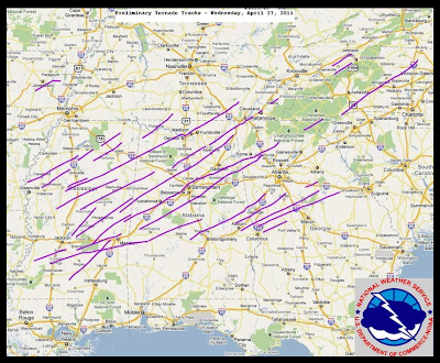
April 27, 2011 Historic Tornado Outbreak Update


Click On The Map To Enlarge It.
Preliminary Tornado Track Map.
National Weather Service- April 2011 Tornado Information.
Click On The Map To Enlarge It.
Map Is Courtesy Of AccuWeather.com.
(Click On This Link To Read Jesse Ferrell's Blog On This Event.)

Staggering Death Toll & Destruction.

Fox News is reporting that the death toll from the Historic Tornado Outbreak that occurred April 27-28, 2011 is now up to 339. That number is expected to continue to rise as many people remain missing, and authorities continue to struggle with the overwhelming and daunting task of search and rescue efforts. This outbreak has now produced the second highest death toll from a tornado outbreak in the nation since the March 18, 1925 event killed 747 people.

The Truth Is Stranger Than Fiction!

Friday, April 29, 2011

Record Heat-High Winds-Extremely Critically Dangerous Fire Weather Conditions Today!

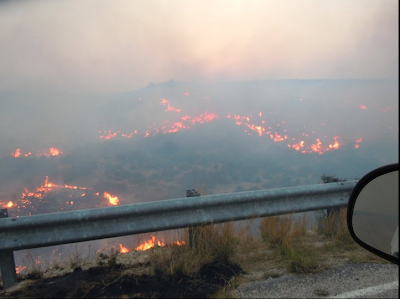
Click On The Photos To Enlarge Them.
Last Chance Fire East Of Queen, NM.
Slurry Drop On The Last Chance Fire Near Queen, NM.
Photos Courtesy Of Joel Arnwine - Eddy Co NM Emergency Mgr.

Hot-Extremely Dry-Windy Today!


Special Weather Briefing Video!

Last Chance Fire Update-

As of 8:30 PM MDT last night the Last Chance Fire was 70% contained. It has burned 53,342 acres so far. For additional information on this and other fires in the state please visit this web site- New Mexico Fire Information.

Here we go again. Our forecast high temperatures here in the Pecos Valley today range from 96 in Hobbs, 98 at Roswell and Artesia, to 99 at Carlsbad. New daily record high temperature records may be established over the area today. Today's highs will be about ten degrees above normal.

A Wind Advisory is in effect for Eddy, Chaves, and Lea Counties today. Hot, dry, down slopping southwesterly winds will kick up around midday at sustained speeds of around 30-40 mph with gusts this afternoon near 55 mph.

A High Wind Warning is in effect through Saturday night at midnight for the Guadalupe Mountains of Eddy County and Culberson County of Texas. Southwesterly-westerly winds are forecast to be sustained at around 30-50 mph with gusts up to around 65 mph.

A High Wind Warning is in effect for Lincoln County today. Southwesterly to westerly winds are forecast to be sustained at around 35-45 mph with gusts up to around 60-65 mph.

Red Flag Warnings are in effect for the entire area today. Extremely Critically Dangerous Fire Weather Conditions are forecast area-wide today. Any wildfire that may break out will have the potential to rapidly spread and grow in the high winds and extremely dry conditions. Please refrain from any type of outdoor activity that involves the use of sparks or flame.

A strong cold front is forecast to move into SE NM on Sunday. Much colder temperatures will accompany its passage. Our forecast high temps for Sunday and Monday range from the upper 50's to low 60's. By Tuesday morning our low temps may be dipping as low as the mid 30's, with a few spots possibly experiencing a light freeze. Yep, its spring all right.

Last night KOB Eyewitness News Channel 4 out of Albuquerque carried a news story and the drought conditions, and the high fire danger in the Artesia area. It was a good story (New Mexico drought at record levels in southeast) up until the part about the rainfall stats in Artesia and Carlsbad. I am not disputing the fact that we are in a serious drought, just the stretch of rainless days that was reported by this network.

The reporter stated that Carlsbad hasn't received any measurable rainfall since Oct 21, 2010, or 0 for the past 189 days. He also stated that Artesia hasn't received measurable rainfall for the past 119 days and Roswell for the past 81 days. The rainfall information is wrong. This is the second news media outlet to make such statements in the past couple of weeks. Come on guys try doing a little research before posting this stuff.

Here Are The Correct Rainfall Totals-

Roswell Climate-

Oct 2010 1.02"
Nov 2010 .00"
Dec 2010 .02"
Jan 2011 .00"
Feb 2011 .21"
Mar 2011 .00"
Apr 2011 .00" (As of 4-28-2011)

Roswell Airport-

Oct 2010 1.02"
Nov 2010 .00"
Dec 2010 .00"
Jan 2011 .00"
Feb 2011 .09"
Mar 2011 .00"
Apr 2011 .00" (As of 4-28-2011)

Artesia Climate Coop Station-

Oct 2010 .06"
Nov 2010 .00"
Dec 2010 .04"
Jan 2011 .00"
Feb 2011 .18"
Mar 2011 .00"
Apr 2011 .00" (As of 4-28-2011)

Carlsbad Climate Coop Station-

Oct 2010 .10"
Nov 2010 .00"
Dec 2010 .01"
Jan 2011 .00"
Feb 2011 .43"
Mar 2011 .00"
Apr 2011 .00" (As of 4-28-2011)

Carlsbad Airport-

Oct 2010 .09"
Nov 2010 .00"
Dec 2010 .00"
Jan 2011 .00"
Feb 2011 T
Mar 2011 .00"
Apr 2011 .00" (As of 4-28-2011)

*Note: I think that the rainfall total for February at the Carlsbad Airport is incorrect. The .00" total listed does not match the other nearby reports in the Carlsbad area, including the Climate Coop Station, which is located just a little ways east of the Airport.

Data Is Courtesy Of-

We also have a volunteer network of rain gauges in the state courtesy of the Community Collaborative Rain, Hail & Snow Network, or better knows as CoCoRaHS.

 Compare the National Weather Service Climate Cooperative rainfall reports with these volunteer reports in Chaves, Eddy, and Lea Counties and you will see that the two are fairly evenly matched. This Network also gives a more widespread view of the rainfall patterns locally. If you keep track of your rainfall  then you may want to think about joining this group. 

The Truth Is Stranger Than Fiction!

Wednesday, April 27, 2011

HISTORIC TORNADO OUTBREAK TODAY!

A Day Of Devastation As The Death Toll Continues To Climb!

Updated Thursday April 28, 2011 1:30 PM MDT-

As the day broke across the Southern US this morning, it was very evident that today's news was not going to be good. It is not, and it gets worse by the hour. According to the major news outlets: Fox News, CNN News, and Yahoo Headline News, the dead toll from yesterday's deadly tornado outbreak stands at around 271 as of 1:30 PM MDT. Hundreds more have been injured. Many people are still missing.The count goes up by the hour, and I am just sickened by all of the death and destruction.

There is little doubt that what we are witnessing is nothing short of historic. Preliminary reports indicate that there were 150 tornadoes that touched down yesterday. Its way too early to know the exact count, and this number may go up or down as the Damage Assessment Teams go to work trying to sort the details out. It will be awhile before the exact number is known.

There were several large violent wedge tornadoes reported, some of these may have been long track tornadoes that stayed on the ground for miles. Its possible that the tornado that ripped through Tuscaloosa, Alabama and then into Birmingham, could have been on the ground for some 300 miles. If this is true, it will be a new US record. The supercell thunderstorm that produced this tornado did track across four states for three hundred miles. So far this April there have been over 600 tornadoes reported across the nation, this will likely set new records as well. A very sad day to remember in American history for sure.

Here are a few Historical Tornado Facts-


"Clearly though this week’s onslaught will rank among the most significant outbreaks in history  Sadly the death toll this morning stood at over 200 and climbing. The death toll from these tornadoes is not unprecedented. The Tri-State tornado of March 18th, 1925 killed 695 people, 234 in the town of Murphysboro alone. Total deaths from tornadoes in 1925 were 800. In 1974, 319 people died from tornadoes, all in one day, April the 3rd. In 1965, 300 died. In 1953, 530 people died from tornadoes in the United States. In 1936, 550 people were killed by tornadoes. In 1927, 540 were killed by tornadoes. In 1917, 550 people were killed by tornadoes. In 1896, 530 Americans were killed by tornadoes."


Click On The Picture To Enlarge It.
Pratt City, Alabama 4-27-2011.
Faye Hyde, right, sits on a mattress in what was her yard as she comforts her granddaughter Sierra Goldsmith, 2, in Conord Ala. Wednesday, April 27, 2011. Their home was completely destroyed. (AP Photo/The Birmingham News, Jeff Roberts).
FoxNews.
Click On The Image To Enlarge It.
I Captured This GRLevel2-AE Integrated Software Image Off Of
The Birmingham, Alabama Radar This Afternoon.
This Is Tuscaloosa, Alabama.

The Top Left Hand Image Is The Base Reflectivity Snapshot.
It Shows The Very Well Defined Hook Echo And Debris Ball.
The Red Triangle Is The Tornado Vortex Signature (TVS).
The Debris Ball Extended Up At Least 8,000' Into
The Air. This Means That The Radar Beam Was Bouncing
Off Of Solid Objects That Were Being Carried This High Up.

The Top Right Hand Image Is The Base Velocity (BV) Snapshot.
The Lower Left Hand Image Is The Storm Relative Velocity (SRV)
Snapshot.

These Two (BV/SRV) Depict The Wind Field Structure Within
The Supercell Thunderstorm. The Greens Represent The Winds
That Are Moving Towards The Radar.The Reds Represents
The Winds That Are Moving Away From The Radar. Where They
Meet In Such A Tight Couplet Is Where Tornadoes Are Likely.

The Bottom Right Image Is The Normalized Rotation (NORT)
Image. It Is Another Way Of Determining Just How Tight/Storng
The Rotation Couplet Is. This NORT Was 2.67, The Strongest
NORT I Have Yet Seen On GRLevel2-AE.

It Is Incredibly Rare That A Doppler Radar Can Actually See
A Tornado. They Detect The Rotation Within The Thunderstorm.
A Tornado Has To Be Close To The Radar And Really Big
In Order For The Radar To Actually See It. Or As In This Case
Slinging Large Amounts Of Debris Into The Air.

The Tornado Outbreak Today May Go Down As The
Worst In The History Of The Country. It May Exceed
The Super Outbreak in April 1974. I Have Never Seen
So Many Tornado Warnings, Debris Balls, And Tight/Strong
SRV Signatures. The SRV Couplets Were Just Off
The Scale With Some Of These Tornadoes. Some Gate To
Gate Shear Couplets Exceeded 175 Knots.

Many Towns And Communities Across Alabama And
Nearby States Have Been Severely Damaged Or Destroyed.
This Will Outbreak I Fear Will Be Historic.

The Truth Is Stranger Than Fiction!

Short Break - More Wind Record High Temps Friday.

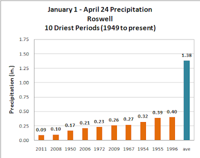
Using records since 1949, January 1 through April 24 of 2011 has been the driest start to the calendar year with just 0.09 inches of precipitation reported.  If we look at the historical data for the Roswell area that dates back to 1895, 2011 still ranks as the driest start to the calendar year.

Peak Wind Gusts Reported Tue-

Guadalupe Pass 85 mph
San Augustin Pass 84 mph
Bowl Raws 71 mph
8-Mile Draw Raws 63 mph
Pinery Raws 61 mph
Cannon AFB - Clovis 60 mph
Sierra Blanca Regional Arpt 60 mph
Dunken Raws 59 mph
Clovis Municipal Arpt 56 mph
Tatum MesoNet 55 mph
High Roll CW5738 55 mph
Smokey Bear Raws 54 mph
Artesia Arpt 52 mph
Carlsbad Arpt 52 mph
Hobbs - KF5KMG 52 mph
Roswell Arpt 51 mph
Carlsbad Portable Raws 51 mph
Sacramento Peak 50 mph
Caprock Raws 48 mph
Queen Raws 45 mph
Bat Draw Raws - Carlsbad Caverns 44 mph

Today will be a much nicer day weather-wise in southeastern New Mexico. It will be cooler with highs generally in the 70's. Tonight will be chilly with lows near 40. A quick warm up will commence tomorrow with high temps of around 85-90.

Our next wind event will start Friday afternoon and continue into the weekend. Record high temps will be possible on Friday. Highs will range from 95-100. Strong southwesterly winds will return Friday afternoon as the fire danger once again escalates into the Critically Dangerous Level.

I recorded a new daily record yesterday for visits to my web page...I really appreciate all of you stopping by and checking this site out. It is my goal to provide you with the very latest up to date information concerning our local weather here in southeastern New Mexico.

I do not get paid for my services, I am a volunteer, and it actually costs me money to maintain this web page. I love writing and talking about our local weather, and enjoy sharing my thoughts and comments with you.

I created this blog site on Oct 23, 200. Since then there have been 54,422 visitors to my site with the web page viewed 103, 827 times as of 6:30 AM MDT this morning. I never dreamed that I would get this kind of response...again thank you for visiting.

Last Chance Fire Update At 2:30 PM MDT-


Click On The Photos To Enlarge Them.
Looking To The Southwest From The Truck Bypass NW Of Town.
Looking To The West From C-Hill.
Looking To The South From C-Hill.

On a normal day I would say that what you are looking at
is thin cirrus clouds. Not so, this is the smoke plume
from the Last Chance Fire, which continues to burn west of 
Carlsbad, New Mexico. I took these photos today.

Last Chance Fire Fact Sheet – 4/27/2011 – 9:30 pm

For Immediate Release: Last Chance Information – (915) 964-4802
Wednesday, April 27th, 2011, 8:30 p.m. Team PIOs Jennifer Myslivy or Joel Arnwine
Acres: 49,140                               Start Date: April 24th 2011
Cause: Under Investigation        Location: 5 miles west of Queen, NM
Containment: 60%                       Fuels: Pinon juniper, brush and grass
Terrain: Steep and Rugged        Resources: 7 crews, 17 engines, 2 water tenders
Total personnel: 252                    Structures: 6 threatened (Queen Subdivision)
                                                       1 destroyed and 2 damaged (Sitting Bull Falls Recreation Area)
Jurisdiction: USFS, BLM, State and Private
Aircraft: Air Attack, one Type 1 helicopter, one Type 3 helicopter and 2 air tankers
 A FINAL public meeting was held tonight at the Queen Fire Department with fire officials to inform the residences of the days fire activity.
 Summary: Excellent progress on the fire was made due to the hard work from firefighters, air resources, and more favorable weather then previous shifts; successful burnout operations continued last night until the relative humidity got too high. Moderate fire behavior was observed adjacent to HWY 137, so a firing operation was conducted around the USFS-Queen Admin Site to tie into existing blackline.
Objectives for tomorrow are to monitor any fire adjacent to HWY 137, continue structure protection for the community of Queen, monitor fire perimeter and extinguish hot spots, and contain fire at the head of Last Chance Canyon,
The road closures on HWY 137 and Dark Canyon Road have been lifted but we are asking the public to proceed with extreme caution when traveling these roads. There may be occasional smoke lingering or drifting over the roads which could cause limited visibility.
The local agencies would like the public to remember that they are in fire restrictions so please check the following website for additional information on area restrictions.http://www.publiclands.org/firenews/NM.php.
CLOSURES:
Sitting Bull Falls Recreation Area (closed until further notice due to fire damage)
Smoke from the fire may continues to impacted the community of Carlsbad and surrounding areas so please take precautious if you have any health or respiratory issues. For more information, NMED’s website, http://www.nmenv.state.nm.us/aqb/Wildfire-PM.html, the DOH websitehttp://www.health.state.nm.us/.
Additional fire information is available at www.nmfireinfo.com or www.inciweb.org.


Last Chance Fire Fact Sheet – 4/26/2011 – 9:30 pm

For Immediate Release:   Tuesday, April 26th, 2011, 9:30 p.m.
 Last Chance Information – (915) 964-4802
 Team PIOs Jennifer Myslivy or Joel Arnwine
Acres: 49,000                             Start Date: April 24th 2011
Cause: Under Investigation     Location: 5 miles west of Queen, NM
Containment: 40%                    Fuels: Pinon juniper, brush and grass
Terrain: Steep and Rugged      Resources: 7 crews, 17 engines, 2 water tenders
Total personnel: 251                 Structures: 6 Structures threatened
Jurisdiction: USFS, BLM, State and Private
Aircraft: Air Attack, one Type 1 helicopter, one Type 3 helicopter and 5 air tankers
 A public meeting was held tonight at the Queen Fire Department with fire officials to inform the residences of the days fire activity. Another meeting has been scheduled for tomorrow night at 7 pm.
 Summary: Excellent progress on the fire was made due to the hard work from firefighters and the 5 air tankers; successful burnout operations continued from last night and throughout the day today which helped secure the fire perimeter into existing roads (FS 277, 405 and HWY 137). Fire personnel used direct suppression tactics following air tanker drops to contain the fire and keep it from moving beyond HWY 137 and into the community of Queen.
A Burned Area Emergency Rehabilitation (BAER) has been ordered by the Lincoln National Forest to evaluate the damage that was caused by the fire.
The local agencies would like the public to remember that they are in fire restrictions so please check the following website for additional information on area restrictions.http://www.publiclands.org/firenews/NM.php.
CLOSURES:
  • Sitting Bull Falls Recreation Area (closed until further notice due to fire damage)
  • HWY 137 at 408
  • Dark Canyon Road at Hidalgo Road
Smoke from the fire continues to impacted the community of Carlsbad and surrounding areas so please take precautious if you have any health or respiratory issues. For more information, NMED’s website, http://www.nmenv.state.nm.us/aqb/Wildfire-PM.html, the DOH websitehttp://www.health.state.nm.us/.
Additional fire information is available at www.nmfireinfo.com or www.inciweb.org. 

The Truth Is Stranger Than Fiction!

Tuesday, April 26, 2011

New Fires Breaking Out In SE NM!

New Fires In SE NM.


Update at 4:15 PM MDT-

New Fires in SE New Mexico – 4:00 pm – 4/26/2011

State Forestry, the BLM and Lea County fire crews are responding to three grass fires this afternoon.  
The Doom Fire is eight miles north of Jal, burning approximately 200 acres of privately owned grassland. Local resources and a NM State Forestry Engine Strike team are responding. No structures are threatened at this time. The fire started along State Highway 18 and is moving toward the Texas State Line.
The Fulfer Fire is approximately 20 acres and is burning about a mile south of Jal along State Highway 18, mile marker 8. Highway 18 has been closed in this area. the Jal Fire Department and the BLM are responding to this incident.
The Jackson Fire is burning north of Artesia along Highway 285 and Jackson Rd. Two structures have been destroyed and an unknown number are threatened at this time. The Artesia Fire Department and other local resources are responding at this time.
--------------------------------------------------------------------------------------------

New Fires in SE New Mexico – 3:00 pm – 4/26/2011

State Forestry, the BLM and Lea County fire crews are responding to three new grass fires this afternoon. NM State Forestry has only preliminary information at this time.
One fire is north of Jal, approximately 2 miles long and headed toward the Texas state line. NM State Forestry’s Engine Strike team is responding to this fire.
The second fire is south of Jal. The Jal Fire Department is responding to this fire.
The third fire is burning along along Highway 128 between Jal and Loving. the BLM and the Loving FD are responding to this incident.


The Truth Is Stranger Than Fiction!

Extreme Fire Danger Threat & High Wind Event Today!

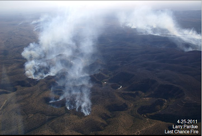
Click On The Photos To Enlarge Them.


These Photos Of The Last Chance Fire Burning West Of
Carlsbad, NM Are Courtesy Of Larry Pardue (N5LP). He Shot Them
From His Plane Yesterday.

Last Chance Fire.

Click On The Image To Enlarge It.
Snapshot Of The Last Chance Fire
Burning West Of Carlsbad, NM. I
Captured This Image At 9:14 AM MDT
This Morning From The GRLevel3
Integrated Software Radar Package
I Use For Skywarn Operations. The Red
Flames Are Satellite Derived Hot-spot
Images From The Fire. These Hot-spots
May Or May Not Still Be Active.
Close Up View Of The Fire.

Latest Update On The Last Chance Fire-


NEWS RELEASE
For Immediate Release: Last Chance Information – (575) 652-5511
Monday, April 25th, 2011, 8:00 p.m. Team PIOs Jennifer Myslivy or Joel Arnwine
Acres:
39,000 Start Date: April 24th 2011
Cause:
Under Investigation Location: 5 miles west of Queen, NM
Containment:
20% Fuels: Pinon juniper, brush and grass
Terrain:
Steep and Rugged Resources: 6 crews, 16 engines, 1 water tenders
Total personnel:
191 Structures: 6 Structures threatened
Jurisdiction:
USFS, BLM, State and Private
Aircraft:
Air Attack, one Type 1 helicopter, one Type 3 helicopter and 5 air tankers
The increase in acreage was the result of a flight this morning that provided more accurate information on fire size and activity.
A Red Flag Warning will continue to be in effect through Tuesday and into the early morning hours of Wednesday; erratic winds and low relative humidity’s hampered fire suppression activities today. Multiple air tankers provided support around the Queen Administrative site during the afternoon when the fire flared up. Due to the flare up, 6 structures on the outskirts of the Queen subdivision was threatened but crews closely monitored the threat.
Summary:
Crews continued to work aggressively to secure the fire perimeter by conducting burn out operations on different section of the fire. Last night’s burnout operations were very successful and helped secure the fire perimeter on Division D which is off the Sitting Bull Falls Road. The following road closures are still in effect:
- HWY137 at 408 (Dark Canyon Road) – State Police blockade
- Dark Canyon Road at Hidalgo Road
Also, the Sitting Bull Falls recreation area is closed to the public due the fire activity in and around the area.
A public meeting was held this evening at the Queen Fire Department with approximately 25 residences in attendance. The Incident Commander informed the residences of today’s fire activities and explained what will be happening in the coming days.
The Carlsbad School District WILL NOT run the bus route from Marathon Road up to Queen tomorrow, so please contact the School Administration Office to let them know if kids are unable to make it to school.
Smoke from the fire will continue to impacted the community of Carlsbad and surrounding areas so please take precautious if you have any health or respiratory issues. For more information, NMED’s website, http://www.nmenv.state.nm.us/aqb/Wildfire-PM.html, the DOH websitehttp://www.health.state.nm.us/.
-------------------------------------------------------------------------------------
I am not sure about the time on the latest update on the Last Chance Fire that continues to burn west of Carlsbad this morning.The New Mexico Fire Information Web Pages last update says 8 AM yesterday.

Anyway, the latest info from that web page states that the fire had burned an estimated 23, 793 acres as of yesterday. It was only 20% contained. 200 personnel are fighting the fire. Three structures were threatened with two of them evacuated. Unconfirmed reports from the Carlsbad Current Argus this morning are indicating that the Sitting Bull Falls Recreational Area may have been damaged by the fire. Westerly winds gusted up to around 55 mph yesterday afternoon impeding the progress of the firefighters somewhat.

Yesterday morning the Martin Fire broke out south of Lovington in Lea County. It reportedly quickly grew to an estimated 25,000 acres, and was three miles wide and seventeen miles long. Several local highways were shut down for a time including Hwy 18. Firefighters were able to stop the forward progress of the fire late yesterday afternoon.

Potentially Damaging High Wind Event!

An Unusually Strong Jet Stream For So Late In The Season
Is Forecast To Plow Overhead Across NM Today. Winds At
The 250 MB/34,000' MSL Are Forecast To Be Around 161
Knots Or 185 MPH. These Winds Will Mix Downward To
The Surface Later This Morning And Help To Produce
The Very High Winds Forecast The State Later Today..
Map Is Courtesy Of The College of DuPage.

As if things were not bad enough, they will quickly get much worse today! A High Wind Warning is in effect today for most of SE NM. Westerly winds will quickly increase later this morning to sustained speeds of around 35-45 mph with gusts of around 60-65 mph across much of the local area. Localized higher gusts will be possible in the normally more wind prone areas, especially near the foothills and mountains.

Some property damage to homes, barns, sheds, and other buildings may occur from these winds today into this evening. Power lines and other suspended cables and lines may be blown down today. High profile as well as low profile vehicles will be subject to dangerous cross winds on north-south facing highways and may be blown off area roadways in the stronger gusts. Westerly winds are forecast to be sustained at around 40-55 mph with gusts in the neighborhood of 75 mph across the Guadalupe Mountains today.

Widespread Blowing Dust!

Widespread areas of blowing dust are likely today across most of the area. Sudden drops in the visibility down to near zero with little to no advanced warning will be possible in the normally more dust prone locations such as freshly plowed farmlands, open fields and lots, and construction sites. Smoke from local fires may combine with the blowing dust to limit the visibility on some local roadways later today.

Potentially Life & Property Threatening Fire Weather Event Today!

With two wildfires already in progress across SE NM the last thing we need is more of them. Sadly there is the potential for additional fires across the area today. An Extremely Critically Dangerous Fire Weather Situation will be in place across all of the area today, with the potential for large wind driven fires that may affect life and property! Please refrain from any type of outdoor activity that involves sparks or flames! Do not drive your vehicles off paved or maintained roadways, and please do not toss your cigarettes out of you vehicles. Please stay abreast of all of our local weather conditions and forecasts today into this evening, and be prepared to quickly evacuate your location should a wildfire threaten your area if local authorities call for such measures.

The Truth Is Stranger Than Fiction!
NWS Albuquerque Burn Scar Matrix Forecast

Current NWS Watches/Warnings In Effect

New Mexico

Eddy County

Chaves County Plains & Mtn's

Culberson County

Lea County

Lincoln County

Otero County

Current US Temps

Current US Wind Chill/Heat Index Temperatures

NWS Midland Forecast

NWS Albuquerque Forecast

NWS Albuquerque Forecast

NWS El Paso Forecast

NWS Lubbock Forecast

NWS Lubbock Forecast

NWS Lubbock Forecast

Average Daily High/Low Temperatures & Rainfall

Average Daily High/Low Temperatures & Rainfall