Major Winter Storm May Paralyze/Bury Parts Of NM & Nearby Areas Tonight Into Wednesday!
Valid At 6 PM MDT Wednesday.
Today's (Sunday) noon mdt run of the GFS forecast model is just plain nuts. Its trend has been to produce heavier snowfall totals and aerial coverages with each new run over the past day. This has me worried. 19" for Roswell, 12" for Artesia, 15" for Clovis, 28" for the Fort Sumner area, and 17" for Corona! This would be wild in the dead of winter but is absolutely unheard of in the part of the world in October! The last time we saw something like this come to pass was the Blizzard of December 27, 28, 29th, 2015. Will history repeats itself? I hope not but I will admit that I am worried. My feeling is that we will see snowfall accumulations of around 6" to 12" in SE NM and 6" to 18" in the mountains.
Valid Tonight Through PM MDT Wednesday.
GFS Sleet Accumulation Forecast.
Valid Tonight Through PM MDT Wednesday.
Freezing drizzle and freezing rain is forecast to develop over parts of the area late tonight and continue into Monday. This may cause some issues on local roadways Monday. Temperatures may warm up enough in a few spots on Monday to melt some of the ice that accumulates but additional periods of freezing rain and sleet are forecast Monday afternoon into Monday night.
Ice accumulations on trees, power lines, and other exposed surfaces are currently forecast to be up to around 1/2 of an inch, possibly higher in places. Downed trees and power lines may cause power outages area-wide.
Accumulating ice and heavy wet snow will likely cause extensive damage to area trees including Pecan Orchards which still have their leaves and are loaded with nuts. Many farmers have not begun their cotton harvesting in SE NM and are just starting in parts of W TX. Sadly damage to their crop may be widespread or even a total loss in places due to the ice and snow.
Travel problems are likely to develop Monday night and continue into Wednesday as heavy wet snow falls on top of the ice and accumulating sleet. Highways will become dangerous and impassable in many areas and road closures appear likely.
Blowing snow and drifting snow will also aggravate driving conditions and whiteouts are possible in the heavier snow bands.
Livestock and range animals will suffer from this storm as well as farm animals especially the local dairy's. Heavy wet snow and freezing rain will stress the animals and make finding feed in open country impossible for them for several days. Ranchers and farmers should be taking steps now to prepare their animals as much as possible for the incoming storm.
Valid At Midnight Tuesday.
Valid At 3 PM MDT Sunday Afternoon.
A fast southward moving back door cold front blew through the Pecos Valley roughly 6 hours ahead of the forecasts this afternoon. We were expecting it to arrive around sunset and midnight and instead it arrived in the Roswell and Artesia areas just before and after 3 PM. This arctic air mass will be reinforced Monday night with a stronger surge pushing south.
An unprecedented and likely historic winter storm has the potential to paralyze, and or bury a large chunk of realistic across New Mexico and nearby areas starting tonight and lasting into Wednesday.
A brutally cold and powerful cutoff mid-upper level low for so early in the season is forecast to dig southward from southern Idaho and northern Utah into southern Arizona by around midnight Monday night. Then ease slowly east-southeastward to just east of El Paso by midnight Tuesday night.
Storm Total Snowfall Forecasts.
Valid Tonight Through 6 PM MDT Wednesday.
Official National Weather Service forecasts as of Sunday afternoon are calling for 4" to 6" in the Roswell area and 1" to 4" in the Artesia, Carlsbad, and Hobbs area. This on top of up to a half of an inch of accumulating ice from freezing rain.
Tuesday.
GFS Wind Chill Temperature Forecast.
Valid At 6 AM MDT Tuesday.
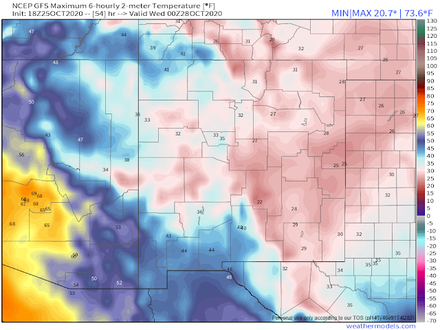
High-temperature forecasts for Monday range from the low to mid 20's in the Clovis and Portales areas, to the mid 30's in the Roswell and Hobbs areas, to the low 40's in the Carlsbad area. I think that some of these highs may be too warm especially in the Carlsbad area since the arctic cold front has arrived sooner than forecast. Nevertheless, we will see the thermometer continue to drop Monday afternoon into Tuesday when highs in SE NM are currently forecast to only be in the mid to upper 20's. High temperatures on Monday and especially Tuesday will be some 40º to 50º below normal for this time of the year.
Wind chill temperatures are forecast to plummet into the single digits across SE New Mexico and much of W TX Monday night into Tuesday morning.
This storm will be a dangerous one affecting most of New Mexico and nearby areas for several days. Travel problems are expected to develop and may become widespread. The models are still struggling with the eventual snowfall totals so there may yet be changes in our local forecasts...possibly for the worst.
The Truth Is Stranger Than Fiction!


Comments
Post a Comment
Your comments, questions, and feedback on this post/web page are welcome.