My Current Weather

Tuesday, October 30, 2012

New Mexico Fall Colors 2012.


Carlsbad, NM Sunrise.
(October 24, 2012).


Supercell Thunderstorm - Downtown Carlsbad, NM.
(October 12, 2012).


Albuquerque, NM Balloon Festival.
(October 6, 2012).


Valley Of Fires State Park.
(October 7, 2012).


Sierra Blanca Peak Lookout.
(October 8, 2012).


Felix Baumgartner's Balloon - 120,000' MSL.
(Looking Northeast From Carlsbad, NM).
(October 14, 2012).


The Truth Is Stranger Than Fiction!

 My Web Page Is Best Viewed With Google Chrome.

Sunday, October 28, 2012

Sandy Will No Doubt Make History!


Blog updated at 1:00 PM MDT.


This mornings 12Z/6 AM MDT NAM 4KM model forecast paints a frightening picture for the New Jersey coast north to NYC early Monday evening. I personally think these folks are in trouble...I hope and pray I am wrong.
Hurricane Sandy: Deadly Storm Surge Brewing For NY, NJ Coastline.
The following comments are from Stu Ostro (he isn't pulling any punches either)-


Quote-


"Just posted this special edition of the trosum (tropical summary) on weather.com ...


Extraordinary storm, extremely serious threat

Stu Ostro, Senior Meteorologist, The Weather Channel
Oct 28, 2012 12:46 pm ET.


- History is being written as an extreme weather event continues to unfold, one which will occupy a place in the annals of weather history as one of the most extraordinary to have affected the United States.

- REGARDLESS OF WHAT THE OFFICIAL DESIGNATION IS NOW OR AT/AFTER LANDFALL -- HURRICANE (INCLUDING IF "ONLY" A CATEGORY ONE), TROPICAL STORM, POST-TROPICAL, EXTRATROPICAL, WHATEVER -- OR WHAT TYPE OF WARNINGS ARE ISSUED BY THE NATIONAL WEATHER SERVICE AND NATIONAL HURRICANE CENTER -- PEOPLE IN THE PATH OF THIS STORM NEED TO HEED THE THREAT IT POSES WITH UTMOST URGENCY.

- TAKE COASTAL FLOODING EVACUATION ORDERS SERIOUSLY; PREPARE FOR DOWNED TREES AND STRUCTURAL DAMAGE BY OBSERVING TORNADO SAFETY GUIDELINES, I.E. STAYING INSIDE AND GETTING INTO THE LOWEST, MOST-INTERIOR PORTION OF THE BUILDING OR ANOTHER DESIGNATED SAFE PLACE; BE KEENLY AWARE OF YOUR LOCATION'S SUSCEPTIBILITY TO FLASH FLOODING (URBAN AND SMALL STREAM) FROM RAINFALL AND RIVER RISES; KNOW THAT YOU COULD BE WITHOUT POWER FOR A LONG TIME BUT ALSO UNDERSTAND THE DANGERS OF CARBON MONOXIDE POISONING FROM IMPROPER USE OF GENERATORS.

- With Sandy having already brought severe impacts to the Caribbean Islands and a portion of the Bahamas, and severe erosion to some beaches on the east coast of Florida, it is now poised to strike the northeast United States with a combination of track, size, structure and strength that is unprecedented in the known historical record there.

- Already, there are ominous signs: trees down in eastern North Carolina, the first of countless that will be blown over or uprooted along the storm's path; and coastal flooding in Florida, North Carolina and Virginia, these impacts occurring despite the center of circulation being so far offshore, an indication of Sandy's exceptional size and potency.

- A meteorologically mind-boggling combination of ingredients is coming together: one of the largest expanses of tropical storm (gale) force winds on record with a tropical or subtropical cyclone in the Atlantic or for that matter anywhere else in the world; a track of the center making a sharp left turn in direction of movement toward New Jersey in a way that is unprecedented in the historical database, as it gets blocked from moving out to sea by a pattern that includes an exceptionally strong ridge of high pressure aloft near Greenland; a "warm-core" tropical cyclone embedded within a larger, nor'easter-like circulation; and eventually tropical moisture and arctic air combining to produce heavy snow in interior high elevations. This is an extraordinary situation, and I am not prone to hyperbole.

- That gigantic size is a crucially important aspect of this storm. The massive breadth of its strong winds will produce a much wider scope of impacts than if it were a tiny system, and some of them will extend very far inland. A cyclone with the same maximum sustained velocities (borderline tropical storm / hurricane) but with a very small diameter of tropical storm / gale force winds would not present nearly the same level of threat or expected effects. Unfortunately, that's not the case. This one's size, threat, and expected impacts are immense.

- Those continue to be: very powerful, gusty winds with widespread tree damage and an extreme amount and duration of power outages; major coastal flooding from storm surge along with large battering waves on top of that and severe beach erosion; flooding from heavy rainfall; and heavy snow accumulations in the central Appalachians.

- Sandy is so large that there is even a tropical storm warning in effect in Bermuda, and the Bermuda Weather Service is forecasting wave heights outside the reef as high as 30'.

- There is a serious danger to mariners from a humongous area of high seas which in some areas will include waves of colossal height. Wave forecast models are predicting significant wave heights up to 50+ feet, and that is the average of the top 1/3, meaning that there will be individual waves that are even higher. The Perfect Storm, originally known as the Halloween Storm because of the time of year when it occurred, peaking in 1991 on the same dates (October 28-30) as Sandy, became a part of popular culture because of the tragedy at sea. This one has some of the same meteorological characteristics and ingredients coming together, but in an even more extreme way, and slamming more directly onshore and then much farther inland and thus having a far greater scope and variety of impacts."

The Truth Is Stranger Than Fiction! 

 My Web Page Is Best Viewed With Google Chrome.

Another Chilly Morning....Warming Up Next Week.


Another chilly morning across southeastern New Mexico and nearby areas with lows generally near freezing. A warming trend will commence today with our afternoon highs climbing up into the 60's. Our highs on Monday are forecast to rise up into the mid 70's to near 80. The rest of the week looks warm also with our highs generally expected to be in the upper 70's to the mid 80's. 

Our local weather for Halloween is looking mild and tranquil. Our afternoon highs should be near 80, and by sunset we will have light winds and temps in the mid 60's, which will drop down to near 50 by 10 PM. Nothing spooky in our local forecast this Halloween.

The Truth Is Stranger Than Fiction!

 My Web Page Is Best Viewed With Google Chrome.

Saturday, October 27, 2012

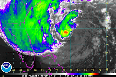
Hurricane Sandy May Threaten 60+ Million People!


At 10:15 AM MDT Saturday October 27, 2012.

At 9:45 AM MDT Saturday October 27, 2012.

Hurricane Sandy was located about 355 miles southeast of Charleston, South Carolina as of 9 AM MDT this morning. She continues moving off to the north-northeast at around 9 mph. Her central pressure is down to 28.29 inches of mercury, or 958 millibars.


Model Forecasts Of Sandy's Track.

00Z/6 PM MDT European (ECMWF) Forecast.
Valid At 6 PM MDT Monday October 29, 2012.

00Z/6 PM MDT Canadian (CMC) Forecast.
Valid At 6 PM MDT Monday October 29, 2012.

06Z/Midnight MDT U.S. NAVY NOGAPS Forecast.
Valid At Noon MDT Monday October 29, 2012.

12Z/6 AM MDT U.S. GFS Forecast.
Valid At 6 PM MDT Monday October 29, 2012.

12Z/6 AM MDT NCEP NAM 10-Meter Forecast.
Valid At 3 PM MDT Monday October 29, 2012.

12Z/6 AM MDT NCEP NAM 4KM Forecast.
Valid At Noon MDT Monday October 29, 2012.


Snowfall Totals Valid At 6 PM MDT Wednesday Oct 31, 2012.

There currently are no meteorological precedents for Hurricane Sandy, which will eventually morph into a hybrid monster once she makes landfall. The weather world is burning down with discussions, blogs, new stories, and chatter about where, and what will Sandy do to the Eastern U.S. Seaboard and nearby areas.

History could be re-written with this one. Some 60+ million people may be affected. Power could be out in many of these areas for weeks, which as crazy as it sounds, could potentially affect the upcoming election. Damages from Sandy could potentially exceed $1 Billion.

Some model forecasts indicate that Sandy may dump up to 12"-15" of rain before she finally dissipates later next week. Inland, heavy snow (maybe more than 2 feet worth) could pile up in parts of the Appalachian Mountains of West Virginia. 

I thought I would do something different, and provide you with some useful links that will help inform you of the many dangers this potentially historic storm posses. No doubt, once Sandy nears the coastal areas somewhere from New Jersey to New York, and makes landfall, her main initial impacts will include the following-

Very heavy rainfall, flooding, flash flooding, high winds (which may be sustained at 80-100 mph), coastal flooding, flooding from storm surges and high tides, downed trees, and downed power lines. No doubt beach erosion and structural damages may be widespread. 

Links To Discussions Of Sandy's Potential Impacts-


The Truth Is Stranger Than Fiction!

 My Web Page Is Best Viewed With Google Chrome.
Low Temps This Morning - Saturday Oct 27, 2012.


Our first widespread freeze of the season occurred overnight. So far, the coldest local low temperature that I can find has been 15F, recorded at the Roswell Portable Raws #1, which is located near Fort Stanton. Close behind is the 17F reading recorded at the personal weather station located in Dry Canyon just east of Cloudcroft. I recorded a low temp of 32.6F here at my home in Carlsbad. 

Today will again be seasonably cool with most of us seeing afternoon highs in the 50's, perhaps a few of the normally warmer spots warming up to near 60F. Tonight will again be chilly with lows in the 30's. Highs on Sunday are forecast to be in the 60's. 

The Truth Is Stranger Than Fiction!

 My Web Page Is Best Viewed With Google Chrome.

Friday, October 26, 2012

Freeze Warning Tonight For All Of SE NM.


Valid At 12Z/6 AM MDT Saturday Morning.

Bundle up tonight, its gonna be chilly. I am going to fire up our fireplace for the first time this season tonight, and maybe even kick back in front of it and read a good book later. 

 A Freeze Warning is now in effect for all of southeastern New Mexico. Overnight lows tonight into early tomorrow morning are forecast to range from the low 20's to near 32F across the lower elevations. Thus ends our growing season for this year. Maybe we will be lucky enough to have a massive kill off of our local bug population...enough of the flies, gnats, and mosquitoes already. 

The Truth Is Stranger Than Fiction!

 My Web Page Is Best Viewed With Google Chrome.

Chilly Today - First Fall Freeze Tonight.


Local temps as of 5 AM MDT this morning were generally ranging from near 30F to near 40F. Today's highs will be chilly as well with most of SE NM seeing the 50's. Freeze Warnings, Hard Freeze Warnings, and Freeze Watches are in effect for the area for tonight into Saturday morning. Please visit the Midland, Lubbock, and Albuquerque National Weather Service Office Web Pages for more details.

The Truth Is Stranger Than Fiction!

 My Web Page Is Best Viewed With Google Chrome.

Thursday, October 25, 2012

Back Of Heat Wave Broken Starting Today!


Temperatures At 4 PM MDT This Afternoon.

Temperatures At Midnight Tonight.

Temperatures At 6 AM MDT Friday Morning.

Temperatures At 6 PM MDT Friday Afternoon.

Temperatures At 6 AM MDT Saturday Morning.

Valid At 6 AM MDT Thursday Oct 25, 2012.

Keep in mind when taking a look at the temperature forecast maps that I have posted above that these maps are just that, a forecast, by this particular model (NAM 4KM), which was issued at midnight last night. So its possible that some locations may see temperatures a little colder, or even warmer, than what is being shown over the next couple of days. But overall you get the idea...colder temps are coming!

Early this morning the cold front was draped across northeastern New Mexico, and is poised to drop south into the local area later today. As of 5 AM MDT this morning, Clayton had a temp of 37F with a north wind gusting to 36 mph behind the front, giving them a wind chill of 25F. A pretty good indicator of what is headed our way.


Before the front arrives in southeastern New Mexico later today, we should see our afternoon high temps climb up into the low-mid 70's. Warm, dry downslopping southwesterly winds have kept our local temps up overnight. As of 5:30 AM MDT this morning, my low here at my home in Carlsbad, NM has only been 61F, with a current temp of 70F.

Gusty northerly winds will accompany the fronts arrival later today. Some gusts may approach 40 mph. Falling temperatures are expected once the colder air arrives tonight along with areas of low clouds.

 Friday promises to be a chilly and breezy day under overcast skies early. I think that most of the area will see afternoon highs in the 40's and 50's. Skies should clear later in the afternoon. Clear skies, along with a colder and drier airmass in place will allow our thermometers to drop tomorrow night into Saturday morning. Most of us will likely see our first freeze of the season Saturday morning. 

Hurricane Sandy!

 Hurricane Sandy At 5:15 AM MDT.


Valid At 6 PM MDT Monday Oct 29, 2012.

Valid At Midnight Monday Oct 29, 2012.


As of 6 AM MDT, Hurricane Sandy was located 75 miles northeast of Holguin, Cuba moving north at 10 mph. Sandy has sustained winds of 105 mph with gusts near 130 mph. Her central pressure is down to 967 millibars, or 28.55 inches of mercury.

Millions of people could potentially be in the path of a Major Hurricane along the Eastern U.S. Seaboard early next week as Sandy treks north. Many questions are on the minds of many people this morning concerning this potential. Sandy's eventual track and strength are still very much uncertain this morning.

 No doubt there are a lot of nervous Meteorologists,  Emergency Managers, and other local official's, in the potential path of this late season monster. Anyone living along the coastline from Virginia northward to New England, really needs to pay attention to this storm and be prepared ahead of time, to take the necessary precautions to protect yourself, and your loved ones in the event Sandy makes landfall near you.

The Truth Is Stranger Than Fiction! 

 My Web Page Is Best Viewed With Google Chrome.

NWS Albuquerque Burn Scar Matrix Forecast

Current NWS Watches/Warnings In Effect

New Mexico

Eddy County

Chaves County Plains & Mtn's

Culberson County

Lea County

Lincoln County

Otero County

Current US Temps

Current US Wind Chill/Heat Index Temperatures

NWS Midland Forecast

NWS Albuquerque Forecast

NWS Albuquerque Forecast

NWS El Paso Forecast

NWS Lubbock Forecast

NWS Lubbock Forecast

NWS Lubbock Forecast

Average Daily High/Low Temperatures & Rainfall

Average Daily High/Low Temperatures & Rainfall