My Current Weather

Sunday, January 31, 2016

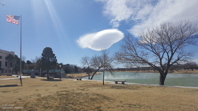
Dangerous High Winds/Blowing Dust/Extreme Fire Danger - Southern/Southeastern/Eastern New Mexico & West Texas Monday!
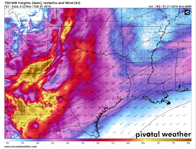

Monday's Winds Have Me Worried!

Valid @ 2 PM MST Monday, February 1, 2016.


Blog Updated @ 7:12 AM MST Monday, February 1, 2016.

SW-W Winds Today Sustained At 35-50 MPH Gusting To 55-65 MPH.

SE NM Plains- SW-W Winds Today Sustained At 30-50 MPH Gusting To 70 MPH!
Guadalupe Mtns- SW-W Winds Today Sustained At 50-70 MPH Gusting To 100 MPH!

Southern NM Lowlands- SW-W Winds Sustained At 35-45 MPH Gusting To 60 MPH!
Southern Sacramento Mtns- SW-W Winds Sustained At 35-45 MPH Gusting To 70 MPH!

Eddy/Lea/Culberson Counties & Parts Of West Texas.

Southern Sacramento Mtns- New Snowfall 2"-5". Near Blizzard Conditions!


San Augustin Pass East Of Las Cruces @ 6 AM MST-  95 MPH!
Sunspot South Of Cloudcroft- 56 MPH!
Cloudcroft- 50 MPH!

I am concerned about today's winds across southeastern New Mexico and nearby areas. The latest NAM-4KM model run at noon yesterday (Sunday) is still forecasting winds at the 700 millibar or the 10,000' level to range from around 50 knots/58 mph near Roswell at 2 PM, to 70-85 knots/81-98 mph across most of Eddy County, and parts of Lea County and southwest to the Guadalupe Pass area.
This mid-level wind speed max will be ripping overhead at about the same time as the Pacific cold front works its way onto the eastern and southeastern plains...headed eastward to West Texas. Our daytime high temps will also be occurring around this time before the colder air behind the front arrives. Once the front arrives our temperatures will drop fairly rapidly.
As the stronger winds aloft mix down to the surface at about the same time as the front moves through, and during the warmest part of the day...we are going to get blasted by southwesterly winds changing around to the west. Current forecasts still have our winds gusting up to the 60-70 mph range today from the Sacramento Mountains eastward to the state line. This includes the Roswell-Artesia-Carlsbad-Tatum-Lovington-Hobbs-and Jal areas. High Wind Warnings are still valid for today into tonight.
With winds this strong over the region including all of southern New Mexico and south into northern Mexico a widespread dust storm seems likely to me. Do not be surprised if sudden drops in the visibility down to zero occur in a dust storm especially over and near: freshly plowed or exposed farmlands, fields, open lots, and construction sites. Travel in some areas may be hindered by these blinding dust storms and some roads may be closed for awhile.
Southeastern New Mexico has a history of multiple car wrecks with multiple vehicle pileups during these violent dust storms. Some of which have had multiple injuries over the past 15 years. In my opinion that potential will exists today.
Wind damage will be a possibility today should these winds be as strong or stronger than forecast. This includes damage to roofs, shingles, sheds, barns, and other outbuildings. Some west facing windows may be blown out as well. Power lines may be blown down as well as power poles and other utility lines and poles. Power outages may be a problem in some areas today. Tree limbs may also be blown down with some trees possibly blown down. Irrigation sprinkler systems may be blown away...even tied down and with water in them in some cases. I've seen that happen many times over the years.
Given how strong the winds aloft are, the timing of the arrival of the cold front, and the models tendency to under forecast our wind speeds, I would not be one bit surprised if some local wind gusts exceed 70 mph across the southeastern plains on today.
Current forecasts call for southwesterly to westerly winds gusts of around 80 mph across the Guadalupe's this afternoon (Sunday) which should drop off to around 65 mph tonight. But then crank back up to the 100 mph range today into tonight. I wouldn't be surprised to see some gusts stronger than 100 mph.
And if the wind was bad enough an extremely high fire weather danger will coincide with today's high winds and blowing dust. Simply put folks avoid all outdoor activity that involves the use of sparks or flame. Any accidental fire that may start will rapidly spread and grow in the high winds and could lead to disaster in a hurry! This could easily cause a life threatening situation with very little to almost no advanced warning.

Stay safe everyone!


The Truth Is Stranger Than Fiction!

High Wind/Blowing Dust Event On Monday Across Parts Of NM & W TX!


Strong winds aloft blowing across the Guadalupe Mountains yesterday created these mountain wave clouds or lenticular clouds southwest-west of Carlsbad, New Mexico. Blowing spray can also be seen coming up over the dam on the river as a result of these gusty southwesterly winds at the surface.


High winds continue to howl across the Guadalupe Mountains early this Sunday morning. As of 4:30 AM MST the Bowl Raws located just north of Guadalupe Peak has already clocked a peak wind gust of 92 mph in the past 24 hours. Guadalupe Pass last reported a peak gust of 79 mph. The ASOS was not reporting as of 4:30 AM MST this morning. Seems like this site goes down every time there is a high wind event up there. Pine Springs has reported a peak gust of 77 mph. Raton has clocked a gust of 70 mph at the airport and the Sierra Blanca Regional airport northeast of Ruidoso has recorded a peak gust of 66 mph. Additional peak wind gusts can be found via this link.

San Augustine Pass east of Las Cruces in the Organ Mountains clocked a peak gust of 70 mph yesterday afternoon. Click on this link for additional peak wind gusts yesterday across southern new Mexico. 


Another Very Warm & Windy Day.


Today will be as warm as yesterday if not a few degrees warmer in a few spots. Most of the local area will see high temps in the mid-upper 70's with a few 80-degree readings possible.

Damaging Winds On Monday!

Valid @ 5 PM MST Monday, February 1, 2016.

Valid @ 5 PM MST Monday, February 1, 2016.

Valid @ 8 AM MST Monday, February 1, 2016.

 From The Surface Up Through 100 MB (53,000' Mean Sea Level/MSL).

Valid @ 11 AM MST Monday, February 1, 2016.

Monday has the potential to be one of those days that goes down in the history books as far as high winds, blowing dust, and the extreme fire danger is concerned. Looking at the NAM forecast model graphic and sounding above we find that by Monday morning the winds aloft over southern and southeastern New Mexico as well as parts of West Texas will be really strong. In fact 50 knot winds or 58 mph winds are forecast for the 850 millibar or 5,000' level. At 700 millibars or the 10,000' level these winds increase to 85-90 knots or 98-104 mph. By the time we get up to the 500 millibar or 18,000' level a strong jet stream is found with 120 knot or 138 mph winds. These extremely strong winds aloft will mix down to the surface, aided by a tight surface pressure gradient, and approaching cold front, all will combine to make for a bad day weather-wise on Monday.

 Damaging southwesterly winds sustained at around 40-60 mph with gusts to near 80 mph are forecast for the Guadalupe Mountains of Eddy and Culberson Counties today. These winds are forecast to back off somewhat tonight and become sustained at around 30-50 mph with gusts near 65 mph. Monday into Monday night they howl furiously out of the southwest sustained at 50-70 mph with gusts to near 90 mph. Tuesday won't be much better either with westerly winds sustained at 30-50 mph with gusts near 70 mph. 

A Wind Advisory remains in effect for Eddy and Culberson Counties today for southwesterly winds sustained at around 25-35 mph with gusts near 50 mph. 

A Wind Advisory remains in effect for Southwest Chaves County and Lincoln County through tonight for southwesterly to westerly winds sustained at around 25-35 mph gusting up to near 50 mph. 

A High Wind Watch is in effect for Eddy and Culberson Counties on Monday for southwesterly winds sustained at around 30-50 mph with gusts to 70 mph. A High Wind Watch is also in effect for Lea County and parts of West Texas on Monday for southwesterly winds sustained at around 35-45 mph with gusts to 60 mph.

A HIgh Wind Watch is in effect for Chaves and Lincoln Counties for Monday for southwesterly to westerly winds sustained at 35-45 mph with gusts to 60-70 mph. A High Wind Watch is in effect for most of southern New Mexico and parts of West Texas for Monday for southwesterly to westerly winds sustained at 35-45 mph gusting to 60 mph.

Blowing Dust May Cause Travel Problems Monday!

Areas of localized blowing dust may develop today especially during the stronger wind gusts and over those normally dust prone locations such as: freshly plowed or exposed farmlands or fields, lots, and construction sites. Widespread blowing dust appears likely for many areas on Monday from southern New Mexico northeastward into southeastern and eastern New Mexico and across West Texas. Sudden drops in the visibility down to zero will certainly be possible especially in dust prone areas experiencing wind gusts of 50-90 mph! There could be some road closures due to these high winds and blowing dust.

With a area wide high event forecast to unfold on Monday do not be surprised if there are not some power outages. Power lines, power poles, other high lines, tree limbs, and roof shingles may all be prone to being blown down on Monday. Some small sheds and outbuildings may also suffer damage or be blown down. This also applies to agriculture irrigation sprinkler systems. Some west facing windows may also be blown out in the stronger gusts of 70-90 mph. 


Red Flag Warnings and Fire Weather Watches continue in effect today into Monday for the local area. Given the very warm temperatures expected today and Monday, the high winds, and a very dry airmass in place, it won't take much for an outdoor fire to rapidly spread and grow. Please avoid any type of outdoor activity that involves the use of sparks or flame...especially on Monday.

Snowfall Forecasts.

Valid @ 5 PM MST Monday, February 1, 2016.

Valid @ 5 PM MST Tuesday, February 2, 2016.

Valid @ 5 AM MST Wednesday, February 3, 2016.

Please visit the El Paso/Santa Teresa and the Albuquerque NWS Web Pages for the latest Winter Storm Watches, Warnings, and Advisories. 

The Truth Is Stranger Than Fiction!

Saturday, January 30, 2016

Near Record To Record Warm Temps & Windy Today.

Our Next Winter Storm Is Southeast Bound.

RAP 500 MB Analysis @ 8 AM MST This Morning.

That yellow X circled in yellow northwest of Seattle, Washington is our next inbound Winter Storm that will have significant and varied impacts upon New Mexico's and surrounding areas weather today into Tuesday. 


This Mornings 12Z/5 AM MST Canadian (GEM) 500 MB Forecast.
Valid @ 11 PM MST Monday, February 1, 2016. 
  
This Mornings 12Z/5 AM MST US Model (GFS) 500 MB Forecast.
Valid @ 11 PM MST Monday, February 1, 2016. 

Last Nights 00Z/5 PM MST European (ECMWF) 500 MB Forecast.
Valid @ 5 PM MST Monday, February 1, 2016. 

Both the US (GFS) and the Canadian (GEM) models have similar tracks and speeds forecasted for this next Winter Storm to impact the area. These models have the center of the mid-upper level storm (500 millibar level or the 18,000' MSL) near the Texas/Oklahoma Panhandles by around midnight Monday. The NAM model (not shown above) pretty much agrees with the GFS and GEM models as far as the storms position Monday night. 

That's when the model are forecasting the storm to take a turn to the northeast and beat up the plains states with heavy snows and in some cases possibly blizzard conditions. Severe thunderstorms are also forecast across the south Sunday into Tuesday.

Last nights run of the European (ECMWF) has the storm slowing down some and just a tad further south that the GFS and GEM models do. It centers the storm near the Four Corners by sunset Monday.

As is always the case the minor differences in model forecasts can and often do have major impacts upon rainfall and snowfall amounts over the state. A further south and slower speed usually means more snow further south. But in most cases the center of a 500 millibar low has to get as far south as a Tucson to El Paso line to drop significant snow across the lowlands of southern and southeastern New Mexico. This is not always the case and there are other factors that play into to this as well. I don't see this happening right now with this storm.

Near Record Warmth/Windy/High Fire Danger Today.


Valid @ 5 PM MST Today.

As the surface pressure gradient tightens up around a surface low located in southwestern Kansas by sunset today, and the stronger winds aloft begin to mix down to the surface, strong southwesterly winds are forecast to rake the local area today especially across the mountains. 

A High Wind Warning is in effect today into Tuesday afternoon for the Guadalupe Mtns of southeastern New Mexico and West Texas. Southwesterly to westerly winds sustained at 45-55 mph with gusts near 75 mph are forecast.  These winds will decrease some tonight but not completely die down and will return again Sunday into Tuesday with sustained speeds of 50-60 mph with gusts to near 80 mph. This is fairly common this time of the year and nothing that unusual for the Guadalupe's. 

A Wind Advisory is in effect for Eddy and Culberson Counties today for southwesterly winds sustained at 25-35 mph with gusts near 50 mph forecast. A High Wind Watch (Monday) and Wind Advisories (Today) are out for the southern Sacramento Mtns and southern New Mexico also. Southwesterly winds will gust up to around 45-50 mph today and near 60 mph on Monday.

Critically Dangerous Fire Weather Conditions/Red Flag Warnings will prevail across the area today into Monday. Simply put please avoid any outdoor activity that involves the use of fire, sparks, or open flame. Any wildfire, range fire, or forest fire will have the ability to rapidly spread in grow in the very warm, dry, and windy conditions.

We may see localized areas/patches of blowing dust this afternoon associated with the stronger wind gusts especially near and over construction sites, open or exposed farmlands, fields, lots, and other normally dust prone locations. 

Welcome to the 80's...no not the era but temperature-wise. Similar readings are forecast for Sunday. A few daily record high temps may be equaled or exceeded today and possibly again on Sunday.

Record High Temperatures For January 30th:

Roswell ThreadEx 82 in 1911.
Artesia Climate 85 in 1911.
Carlsbad Climate 88 in 1911.
Carlsbad Airport 81 in 1971
Hobbs Climate 80 in 1967.
Tatum Climate 82 in 1988.
Ruidoso Climate 68 in 1971.
Cloudcroft Climate 51 in 2014.
Alamogordo Climate 75 in 1967.

Local Climate Data Is Courtesy Of:


This Mornings 12Z/5 AM MST GFS Accumulated Snowfall Forecast.
Valid @ 5 PM MST Monday, February 1, 2016. 

This Mornings 12Z/5 AM MST Canadian (GEM) Accumulated Snowfall Forecast.
Valid @ 5 PM MST Monday, February 1, 2016. 

This Mornings 12Z/5 AM MST WPC Accumulated Snowfall Forecast.
Valid @ 5 AM MST Tuesday, February 2, 2016. 
(Worst Case Scenario).

This Mornings 18Z/11 AM MST NDFD (NWS) Accumulated Snowfall Forecast.
Valid @ 5 PM MST Monday, February 1, 2016. 

As you are aware of by now each model has a different snowfall total forecast. This is typical and seldom do they agree completely. So use these forecasts as a general guide...taken with a grain of salt or question. This given that any change in the storms actual track and speed will have a direct bearing on these and other forecasts.

The Truth Is Stranger Than Fiction!

Friday, January 29, 2016

Highs Winds - High Fire Danger - Colder Temps & Snow Return To New Mexico.


This Mornings 12Z/5 AM MST GFS 250 MB (34,000' MSL) Jet Stream Analysis.

A powerhouse of a jet stream (as depicted by the graphic above at the 34,000 foot level) is currently slicing across the Pacific Ocean. A jet stream wind speed max of 231 knots or 266 mph is shown just north of Japan. These really fast winds speeds in the jet stream contain a lot of energy or lift which is forming some potent storms which cycle eastward from Japan to the Gulf of Alaska and the Pacific Northwest US Coastline. So in short the jet stream continues to help produce some powerful winter storms out over the Pacific Ocean (in this very strong El NiƱo winter) which eventually slam into the Western US Coastline. 


This Mornings GFS 250 MB (34,000' MSL) Jet Stream Forecast.
Valid @ 5 PM MST Monday, February 1, 2016. 

This Mornings GFS 500 MB "Heights" Forecast.
Valid @ 5 PM MST Monday, February 1, 2016. 

A potent mid-upper level winter storm was approaching the Pacific Northwest Coast early this morning. This storm is forecast to dive southeastward and by around sunrise Monday morning be centered near souther Nevada. Forecast models then swing it eastward across New Mexico Monday into Tuesday morning. 

Strong-High Winds Saturday Into Monday.

Valid @ 5 AM MST Monday, February 1, 2016. 

Valid @ 5 AM MST Monday, February 1, 2016. 

Current model forecasts indicate that strong southwesterly winds will rake the local area Saturday into Monday. Southwesterly to westerly winds are forecast to pick up today across the Guadalupe Mountains and increase Saturday into Monday. By Monday morning near sunrise the GFS forecast model (see the two graphics above) depict winds at the 700 millibar or 10,000' level to increase to 60-70 knots or 69 to 81 mph. These very strong mid-level winds will overspread southern and southeastern New Mexico on Monday.

Warm daytime temperatures, mixing of the atmospheric winds downward from the jet stream level to the surface, and a very tight surface pressure gradient ahead of the approaching strong winter storm will all combine to generate strong to high winds locally Saturday into Monday. Wind gusts across the Guadalupe Mountains today will be near 50 mph, A High Wind Watch is in effect for the Guadalupe Mountains of Eddy and Culberson Counties from Saturday through Tuesday. Southwesterly to westerly winds are forecast to gust between 60-80 mph during this time.

Winter Returns To New Mexico.


Valid @ 5 AM MST Monday, February 1, 2016.

Heavy snows will return to parts of New Mexico this weekend into Tuesday. At this time it appears that the greatest impacts will occur over the western mountains, northwestern and northern parts of the state as well across the central mountain chain.

Meanwhile in southern and southeastern New Mexico and parts of West Texas warm dry and windy weather will prevail today ahead of the storm with a turn to colder weather by Monday night into Tuesday. A change for some rain and snow will also be in the cards Monday night into Tuesday. 

Our biggest concerns for the immediate future will be the High Fire Danger and strong southwesterly winds that may produce areas of blowing dust at times Saturday afternoon into Monday. Across the southeastern plains southwesterly to westerly winds are forecast to gust up to around 40 mph on Saturday, 40-50 mph on Sunday, and in the 50-60 mph range on Monday. A Fire Weather Watch is in effect for Saturday.

Daytime high temperatures will run some 10 to 20 degrees above normal today into Sunday will readings in the 70's. A few of us may get close to the 80-degree mark Saturday and Sunday. Mondays highs will drop behind an approaching cold front with readings in the 50's and by Tuesday we will see readings in the 40's if not colder.


This Mornings 12Z/5 AM MST GFS Accumulated Snowfall Forecasts.
Valid @ 5 PM MST Tuesday, February 2, 2016.

This Mornings Canadian (GEM) Accumulated Snowfall Forecast.
Valid @ 5 PM MST Tuesday, February 2, 2016. 

This Mornings WPC Snowfall (Worst Case Scenario) Forecast.
Valid @ 5 AM MST Monday, February 1, 2016. 

Please remember that these snowfall forecasts may and in all likelihood will change between now and Tuesday. This as the models settle down and get a better analysis and forecast in the strength and track on the approaching winter storm. 

The Truth Is Stranger Than Fiction!

Monday, January 25, 2016

Fast Moving Storm To Dump Light Snowfall Across Parts of SE NM.


Blizzard Of 2016 Snowfall Reports.


Cooler Today - Colder Tuesday With Some Snow.

Valid @ 11 AM MST Tuesday, January 26, 2016.

Valid @ 11 AM MST Tuesday, January 26, 2016.

Valid @ 11 AM MST Tuesday, January 26, 2016.

As one upper level disturbance departs the state today a second one will drop southward through New Mexico later today and into southern New Mexico by tomorrow morning. This next system will be a little colder and wetter therefore snow is in our local forecast. Most of the heavier snows are forecast to fall across northeastern and eastern New Mexico late this afternoon into Tuesday.

 A mix of light rain and light snow is forecast for the southeastern plains. Light rain and snow showers should enter the local area (Chaves and Lincoln Counties first) late tonight or early Tuesday morning and end before midnight Tuesday night. 


Today will be cooler with our afternoon high temperatures mostly in the 50's. Tuesday will be a little colder with highs in the upper 30's to the mid 40's. Our highs on Tuesday will be some 10 to 20 degrees below normal for this time of the year.

Model Snowfall Forecasts.

Valid @ 11 PM MST Tuesday, January 26, 2016.

Valid @ 5 PM MST Wednesday, January 27, 2016.

Valid @ 5 AM MST Thursday, January 28, 2016.

Valid @ 5 AM MST Wednesday, January 27, 2016.

Current National Weather Service forecasts are calling for perhaps and inch or two of snow in the Ruidoso, Roswell, and Elk areas with a dusting to perhaps an inch in some places across the rest of southeastern New Mexico. This inbound storm will be somewhat moisture starved therefore one of the reasons for the low snowfall totals forecast. Another reason for this is that the ground is fairly warm due to our recent stretch of warm and dry weather, and given that this next storm will exit the area fairly quickly and not linger.

The Truth Is Stranger Than Fiction!

NWS Albuquerque Burn Scar Matrix Forecast

Current NWS Watches/Warnings In Effect

New Mexico

Eddy County

Chaves County Plains & Mtn's

Culberson County

Lea County

Lincoln County

Otero County

Current US Temps

Current US Wind Chill/Heat Index Temperatures

NWS Midland Forecast

NWS Albuquerque Forecast

NWS Albuquerque Forecast

NWS El Paso Forecast

NWS Lubbock Forecast

NWS Lubbock Forecast

Average Daily High/Low Temperatures & Rainfall

Average Daily High/Low Temperatures & Rainfall