My Current Weather

Tuesday, February 23, 2016

Our Break From Spring Like Weather Is Over - Winter Has Returned.


Sierra Blanca Peak At Sunset Friday, February 19, 2016. 


As Of 9 AM MST This Morning. 

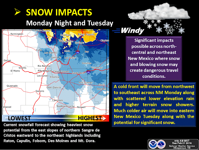
As of 9 AM MST this morning a mid-upper level low was centered near Wichita Falls, Texas with a trough of low pressure and embedded disturbances located over New Mexico behind the storm. This is the storm that has produced the snow and rain over the state since yesterday.

A broken line of thunderstorms developed late yesterday afternoon across the Tularosa Basin and extended northeastward into northeastern New Mexico. This line of storms moved southeastward along and ahead of a cold front and into southeastern New Mexico early yesterday evening, producing frequent cloud to ground lightning strikes, light to moderate rain showers, and a few reports of small hail. Blowing dust also accompanied the storms. The 8-Mile Draw Raws Automated Weather Station located northeast of Roswell clocked a peak wind gust of 72 mph. The Carlsbad Airport reported a peak gust of 52 mph and the Artesia Airport reported a peak gust of 55 mph.

Light rain has started falling here in Carlsbad as of 9:45 AM MST this morning. Light rain is also being reported in Clovis, Roswell, and Artesia. According to radar snow is falling just north of Roswell northward into northeastern New Mexico and across parts of the Texas Panhandle and northern South Plains. Local web cams show that snow is falling in the Ruidoso area.

 (Updated: As Of 3:00 AM MST Wednesday, Feb 24, 2016.)

• 8 W Raton - 12.0 in.
 • 8 SSW San Miguel - 11.0 in.
 • 8 SE Eagle Nest - 10.0 in.
 • 8 SW Rociada - 10.0 in.
 • Nambe - 9.0 in.
 • 3 ESE Angel Fire - 8.0 in.
 • 5 ESE Black Lake - 7.5 in.
 • Tres Piedras - 7.2 in.
 • 6 WNW Tererro - 7.0 in.
 • Red River - 7.0 in.
 • 1 WNW White Rock - 6.2 in.
 • Angel Fire - 6.0 in.
 • 7 E Canjilon - 6.0 in.
 • 14 NE Gladstone - 6.0 in.
 • 9 ENE Shady Brook - 6.0 in.
 • 13 E Gladstone - 6.0 in.
 • 5 NW Lamy - 5.7 in.
 • 7 ESE Cuba - 5.0 in.
 • 6 WNW Sugarite - 5.0 in.
 • Glorieta - 5.0 in.
 • 11 ENE Red River - 5.0 in.
 • 12 N Grenville - 5.0 in.
 • 7 E Albuquerque - 4.9 in.
 • 6 NW Rosebud - 4.0 in.
 • 8 NE Arroyo Seco - 4.0 in.
 • 12 NNW Jemez Springs - 4.0 in.
 • 5 SSE Santa Fe - 4.0 in.
 • 8 E Albuquerque - 4.0 in.
 • 9 E Cuba - 4.0 in.
 • Eagle Nest - 3.5 in.
 • 5 ESE Red River - 3.0 in.
 • 2 SE Alto - 3.0 in.
 • 5 NW Chama - 3.0 in.
 • Roy - 3.0 in.
 • 8 SSW Red River - 3.0 in.
 • 4 E Sandia Park - 2.5 in.
 • 1 ESE Abbott - 2.5 in.
 • 2 SW Edgewood - 2.5 in.
 • 2 S Edgewood - 2.0 in.
 • Springer - 2.0 in.
 • Vermejo Park - 2.0 in.
 • 1 S Clines Corners - 2.0 in.
 • 6 W Los Alamos - 2.0 in.
 • Mountainair - 2.0 in.
 • 5 NW Canones - 2.0 in.
 • 6 WNW Espanola - 1.8 in.
 • 8 ESE Albuquerque - 1.5 in.
 • 3 NW Tres Ritos - 1.5 in.
 • 2 S Arabela - 1.5 in.
 • 6 NNW Guadalupita - 1.5 in.
 • 1 SSE Glorieta - 1.4 in.
 • 6 SSE Santa Fe - 1.3 in.
 • 2 E Espanola - 1.2 in.
 • Santa Fe - 1.1 in.
 • 2 E San Pablo - 1.0 in.
 • 7 SE Clines Corners - 1.0 in.
 • 3 NNE Raton Crews Airport - 1.0 in.
 • 4 N La Plata - 1.0 in.
 • Questa - 1.0 in.
 • Costilla - 1.0 in.
 • Chama - 1.0 in.
 • 7 ESE Kenna - 1.0 in.
 • 2 N Chama - 1.0 in.
 • 1 SSW Philmont Scout Ranch - 1.0 in.
 • 1 SE Cerro - 1.0 in.
 • 4 NNW Lamy - 1.0 in.
 • 3 ENE Tucumcari - 1.0 in.
 • El Vado - 1.0 in.
 • 1 SSW Los Ojos - 1.0 in.
 • 7 ESE Chupadero - 1.0 in.
 • 1 ESE Truchas - 0.9 in.
 • 1 ENE Santa Fe - 0.8 in.
 • 6 SSE Santa Fe - 0.8 in.
 • 3 SSW Santa Fe - 0.7 in.
 • 2 WNW Manuelitas - 0.7 in.
 • 1 WSW Santa Fe - 0.6 in.
 • 5 N Edgewood - 0.5 in.
 • 3 SE Farmington - 0.5 in.
 • 3 NE Tucumcari - 0.5 in.
 • 3 SSW Encino - 0.5 in.
 • 1 WNW Navajo Dam - 0.4 in.
 • 4 W Mountainair - 0.4 in.
 • 5 NW Lamy - 0.3 in.
 • 5 NW Lamy - 0.3 in.
 • 2 N Milan - 0.3 in.
 • 2 NNE Questa - 0.3 in.
 • 4 NE Albuquerque - 0.3 in.
 • 2 SW Agua Fria - 0.3 in.
 • 1 W Santa Fe - 0.2 in.
 • 5 S Albuquerque - 0.1 in.
 • 1 SSW Tijeras - 0.1 in.
 • 1 W Grants - 0.1 in.


The Truth Is Stranger Than Fiction!
Sunday, February 21, 2016

You Know When Its 91°F In February In NM Something Is Up. It Is - Winter Returns Mon & Tue.


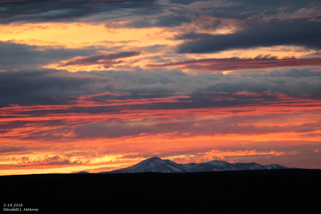
Sierra Blanca Peak At Sunset 2-19-2016.


500 MB Forecast Valid @ 5 AM MST Tuesday, February 23, 2016.

Temperature Forecast Valid @ 5 PM MST Tuesday, February 23, 2016.

Storm Total Rainfall Forecast Valid @ 11 PM MST Tuesday, February 23, 2016.

Accumulated Snowfall Forecast Valid @ 11 PM MST Tuesday, February 23, 2016.

WPC Accumulated Snowfall Forecast.
Valid @ 5 AM MST Wednesday, February 24, 2016.

This past Thursday was a rather remarkable day for the local area. Roswell topped out with a high temperature of 91°F at the Airport which not only established a record high for the day (beating the old record of 83°F in 1986) but also established a new all time high for the month of February (beating the old record of 88°F set on Feb 24, 1904). This was also the earliest that Roswell had reached 90°F beating the previous record of 90°F on March 2, 1967. \

Here in Carlsbad I recorded a high temperature of 90°F last Thursday. The Carlsbad Climate Co-Op Station and the Carlsbad Airport both recorded high temperatures of 88°F, both of which were also new record high temperatures for the date. The Carlsbad Climate Co-Op Station beat their previous record of 82°F set in 1977 and the Airport beat their previous record of 85°F set in 1996. 

The Artesia Climate Co-Op Station recorded a high temperature last Thursday of 87°F which beats the old record for the date of 83°f which was set in 1970. The Tatum Climate Co-Op Station recorded a high temperature of 84°F which beat the old record of 78°F set in 2011. 

The Cloudcroft Climate Co-Op Station recorded a high temperature last Thursday of 61°F which beat the old record of 58°F set in 1951.  

Winter Returns Monday Night Into Wednesday.

A fast moving cold front approaching from the north will sweep across the area Monday night into Tuesday morning. Meanwhile a trough of low pressure that will be deepening and diving southeastward out of the Idaho and Utah areas on Monday will take aim on the state Monday night into Wednesday morning. The Canadian model (GEM) seems at this time to have the best handle on this fast moving winter storm to impact the state.  


Northern and northeastern New Mexico are currently forecast to receive the brunt of this next storms heaviest snows. Several of the models have up to or close to a foot of snow falling across the northeastern third of the state including the Raton area. If the Canadian model (see graphic above) is correct with its snowfall forecast then accumulating snows may fall as far south as the Tatum area by  Tuesday night. Both the Canadian and the WPC models have snow falling over most of southeastern New Mexico but not accumulating by Tuesday night. Most of the local area will only see afternoon highs in the mid 30's to mid 40's Tuesday if the Canadian is correct. 


Believe it or not but a few isolated thunderstorms may approaching or become marginally severe Monday afternoon and evening. Low level southeasterly upslope flow is forecast to return to the area on Monday and deepen Monday night. Good lift and dynamics aloft ahead of the approaching cold front and upper level storm will provide an unstable atmosphere over southeastern New Mexico and parts of West Texas. Thunderstorms will be possible and capable of producing hail, gusty winds, and dangerous cloud to ground lightning. 

The Truth Is Stranger Than Fiction!

Wednesday, February 17, 2016

Ridiculously Warm Today - Downright Hot On Thursday.


Forecast Temperature Anomalies Today @ 5 PM MST. 

Forecast High Temps Today.

Forecast High Temps Today.


Forecast Temperature Anomalies Thursday @ 5 PM MST..

Forecast High Temps Thursday.

Forecast High Temps Thursday.


Hot, dry, and a bit on the windy side will characterize Thursday's weather across much of the area. A few spots are going to flirt with the 90°F mark believe it or not.  Today's will be abnormally warm as well with highs mostly in the mid-upper 70's. A Fire Weather Watch has been issued for southeastern New Mexico and nearby areas for Thursday.

The Truth Is Stranger Than Fiction!

Monday, February 15, 2016

Warm Week Ahead - Record High Temps Possible Wed & Thu.


Valid @ 5 PM MST Thursday, February 18,2016.


Forecast High Temperatures On Tuesday.


Forecast High Temperatures On Wednesday.


Forecast High Temperatures On Thursday.


Forecast High Temperatures For Friday.


High temperatures across the area this week will continue to remain above normal. By Thursday which is forecast to be the warmest day of the week locally our highs will be running some 15°F to 25°F above normal. Notice that the GFS model is even forecasting a high of 90°F in the Wink/kermit/Pecos, Texas area on Thursday. 

Many locations will likely tie or break their daily high temperature records on Wednesday and more so on Thursday. Rather unusual for the middle of February but not totally unheard of.

Local Record High Temps For Thursday, Feb 18, 2016.

Roswell 83°F 1996.
Artesia 83°F 1970.
Carlsbad 82°F 1977.
Carlsbad Arpt 85°F 1996.
Tatum 78°F 2011.
Hobbs 83°F 1996.

Picacho 76°F 1976.
Ruidoso 68°F 1986.
Capitan 71°F 2004.
Elk 75°F 1958.
Cloudcroft 58°F 1951.

Climate Data Is Courtesy Of-


The Truth Is Stranger Than Fiction!

Saturday, February 13, 2016

Solar Cycle #24 Lowest Activity In 200 Years.


Our big bright yellow star continues to exhibit lower than average sunspot activity as solar cycle #24 comes to a close in a couple of years. The sunspot number in January was 56.6, which is 71% of the mean this far into the period, calculated using the 23 previously measured solar cycles. The current level of solar activity with solar cycle #24 is being compared to solar cycle #5 which occurred in the beginning of May 1798 and ended in December 1810 (thus falling within the Dalton Minimum 1790-1830).

Weakest Solar Cycle In More Than A Century Now Heading Towards The Next Solar Minimum. 


"The current solar cycle, #24, is the weakest solar cycle in more than a century and it is now heading towards the next solar minimum phase which would be the beginning of solar cycle #25.  The last solar minimum phase lasted from 2007 to 2009 and it was historically weak. In fact, it produced three of the most spotless days on the sun since the middle 1800’s (bar graph below).  The current solar cycle is the 24th solar cycle since 1755 when extensive recording of solar sunspot activity began.  Solar cycle 24 is currently on pace to be the weakest sunspot cycle with the fewest sunspots since cycle 14 peaked in February 1906. Solar cycle 24 continues a recent trend of weakening solar cycles which began with solar cycle 22 that peaked around 1990."

400 Years Of Sunspot Observations.


"The increasingly likely outcome for another historically weak solar cycle continues the recent downward trend in sunspot cycle strength that began over thirty years ago during solar cycle 22. If this trend continues for the next couple of cycles, then there would likely be increasing talk of another “grand minimum” for the sun which correlates to an extended decades-long period of low solar activity. Some solar scientists are already predicting that the next solar cycle will be even weaker than this current one which has been historically weak. However, it is just too early for high confidence in those predictions since many solar scientists believe that the best predictor of future solar cycle strength involves activity at the sun’s poles during a solar minimum phase – something we are now rapidly approaching."

Year Without A Summer.

In 1815 Mount Tambora erupted (the largest eruption in 1,300 years) in the Dutch East Indies and helped produce the "Year Without A Summer." Note that this event occurred near the end of the Dalton Minimum or close of the Little Ice Age. 

"The Year Without a Summer was an agricultural disaster. Historian John D. Post has called this "the last great subsistence crisis in the Western world".[5][6] The unusual climatic aberrations of 1816 had the greatest effect on most of New England, Atlantic Canada, and parts of western Europe. Typically, the late spring and summer of central and northern New England and southeastern Canada are relatively stable: temperatures (average of both day and night) average between about 68 and 77 °F (20 and 25 °C) and rarely fall below 41 °F (5 °C).

North America.

In the spring and summer of 1816, a persistent "dry fog" was observed in parts of the eastern U.S. The fog reddened and dimmed the sunlight, such that sunspots were visible to the naked eye. Neither wind nor rainfall dispersed the "fog". It has been characterized as a "stratospheric sulfate aerosol veil".[7]
At higher elevations, where farming was problematic in good years, the cooler climate did not quite support agriculture. In May 1816,[1] frost killed off most crops in the higher elevations of New England and New York. On June 6, snow fell in Albany, New York, and Dennysville, Maine.[8]
Many commented on the phenomenon. Sarah Snell Bryant, of CummingtonMassachusetts, wrote in her diary, "Weather backward."[9]
At the Church Family of Shakers in upstate New York, near New Lebanon, Nicholas Bennet wrote in May 1816, "all was froze" and the hills were "barren like winter." Temperatures went below freezing almost every day in May. The ground froze solid on June 9. On June 12, the Shakers had to replant crops destroyed by the cold. On July 7, it was so cold, everything had stopped growing. The Berkshire Hills had frost again on August 23, as did much of the upper northeast.[10]
A Massachusetts historian summed up the disaster: "Severe frosts occurred every month; June 7th and 8th snow fell, and it was so cold that crops were cut down, even freezing the roots .... In the early Autumn when corn was in the milk it was so thoroughly frozen that it never ripened and was scarcely worth harvesting. Breadstuffs were scarce and prices high and the poorer class of people were often in straits for want of food. It must be remembered that the granaries of the great west had not then been opened to us by railroad communication, and people were obliged to rely upon their own resources or upon others in their immediate locality."[11]
In Cape May, New Jersey, frost was reported five nights in a row in late June, causing extensive crop damage.[12]
In July and August, lake and river ice was observed as far south as northwestern Pennsylvania. Frost was reported as far south as Virginia on August 20 and 21.[13] Rapid, dramatic temperature swings were common, with temperatures sometimes reverting from normal or above-normal summer temperatures as high as 95 °F (35 °C) to near-freezing within hours. The weather was not in itself a hardship for those accustomed to long winters. The real problem lay in the weather's effect on crops and thus on the supply of food and firewood. Thomas Jefferson, retired from the presidency and farming at Monticello in Virginia, sustained crop failures that sent him further into debt. On September 13, a Virginia newspaper reported that corn crops would be one half to two-thirds short, and lamented that "the cold as well as the drought has nipt the buds of hope."[14] A Norfolk, Virginia Newspaper complained: "It is now the middle of July, and we have not yet had what could properly be called summer. Easterly winds have prevailed for nearly three months past... the sun during that time has generally been obscured and the sky overcast with clouds; the air has been damp and uncomfortable, and frequently so chilling as to render the fireside a desirable retreat."[15]
Regional farmers did succeed in bringing some crops to maturity, but corn and other grain prices rose dramatically. The price of oats, for example, rose from 12¢ a bushel ($3.40/m³) in 1815 (equal to $1.55 today) to 92¢ a bushel ($26/m³) in 1816 ($12.83 today). Crop failures were aggravated by an inadequate transportation network: with few roads or navigable inland waterways and no railroads it was expensive to import food.[16]."


"The Maunder Minimum, also known as the "prolonged sunspot minimum", is the name used for the period starting in about 1645 and continuing to about 1715 when sunspots became exceedingly rare, as noted by solar observers of the time.
The term was introduced after John A. Eddy[1] published a landmark 1976 paper in Science.[2] Astronomers before Eddy had also named the period after the solar astronomers Annie Russell Maunder (1868–1947) and E. Walter Maunder (1851–1928), who studied how sunspot latitudes changed with time.[3] The period the husband and wife team examined included the second half of the 17th century. Two papers were published in Edward Maunder's name in 1890[4] and 1894,[5] and he cited earlier papers written by Gustav Spƶrer.[6] Due to the social climate of the time, Annie's contribution was not publicly recognized.[7]
Spƶrer noted that, during one 28-year period within the Maunder Minimum (1672–1699), observations showed fewer than 50 sunspots, as opposed to a more typical 40,000–50,000 spots in modern times.[8]
Like the Dalton Minimum and Spƶrer Minimum, the Maunder Minimum coincided with a period of lower-than-average European temperatures.
The Maunder Minimum occurred between 1645 and 1715 when very few sunspots were observed. This was not due to a lack of observations; during the 17th century, Giovanni Domenico Cassini carried out a systematic program of solar observations at the Observatoire de Paris, thanks to the astronomers Jean Picard and Philippe de La HireJohannes Hevelius also performed observations on his own. 
During the Maunder Minimum enough sunspots were sighted so that 11-year cycles could be extrapolated from the count. The maxima occurred in 1676, 1684, 1695, 1705 and 1716.
The sunspot activity was then concentrated in the southern hemisphere of the Sun, except for the last cycle when the sunspots appeared in the northern hemisphere, too.
According to Spƶrer's law, at the start of a cycle, spots appear at ever lower latitudes until they average at about latitude 15° at solar maximum. The average then continues to drift lower to about 7° and after that, while spots of the old cycle fade, new cycle spots start appearing again at high latitudes."

Sunspot Number Progression.


As the sun continues to quieten down as far as sunspot activity goes - what lies ahead? A question that is hotly debated. Many scientists, climatologists, meteorologists believe that we are headed for another Dalton Minimum or perhaps even a Maunder Minimum. So the question remains which is are we headed towards another Little Ice Age? 
The Truth Is Stranger Than Fiction!

NWS Albuquerque Burn Scar Matrix Forecast

Current NWS Watches/Warnings In Effect

New Mexico

Eddy County

Chaves County Plains & Mtn's

Culberson County

Lea County

Lincoln County

Otero County

Current US Temps

Current US Wind Chill/Heat Index Temperatures

NWS Midland Forecast

NWS Albuquerque Forecast

NWS Albuquerque Forecast

NWS El Paso Forecast

NWS Lubbock Forecast

NWS Lubbock Forecast

Average Daily High/Low Temperatures & Rainfall

Average Daily High/Low Temperatures & Rainfall