Posts

Showing posts from 2014

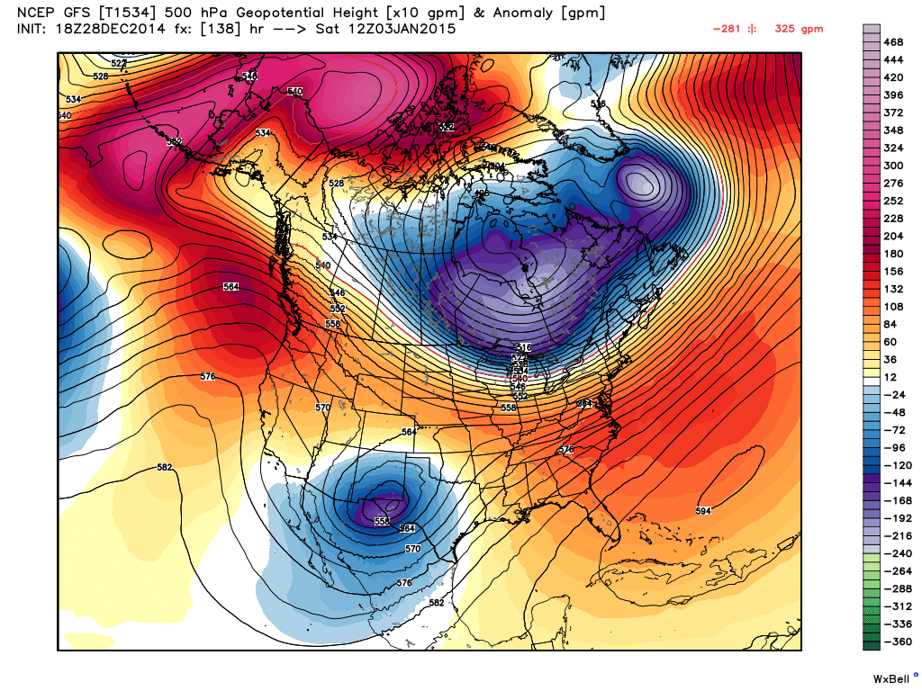
Arctic Air Grips NM - Winter Storm Approaching From California.

Image
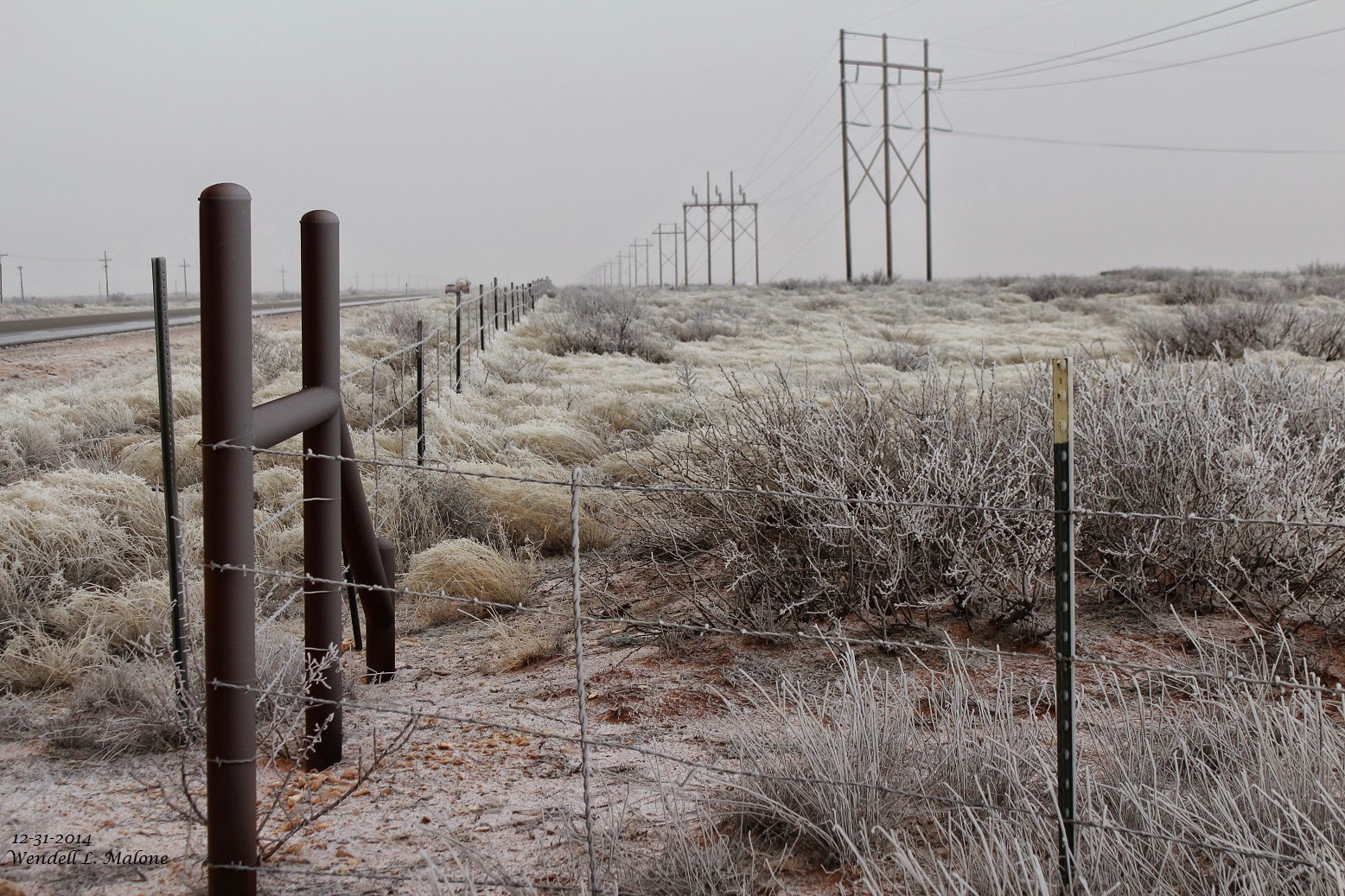
Blog Updated @ 4:35 PM MST Today. Glazing from light freezing drizzle and light freezing fog at the Red Hills Gas Plant (Agave Energy Co) this morning. Located 21 miles WNW of Jal, NM, in Lea Co, at MM32 on St Hwy 128. Snow packed roads in Carlsbad, NM this morning. A layer of black ice lies underneath the snow on local roads and highways in and around Carlsbad. Extremely slick conditions exists. We now have 11/2" of snow on the ground at our home here in NW Carlsbad. Potent Closed 500 MB Low Headed To NM. Water Vapor Satellite Image @ 9:15 AM MST This Morning. GFS 500 MB Closed Low @ 12Z/5 AM MST This Morning. Temperatures & Wind Chill's @ 8 AM MST This Morning. Temperatures @ 3 PM MST Today. Reported Low Temps This Morning. Snow Depth This Morning. GFS (T1534) Snowfall Forecast. Valid @ 18Z/11 AM MST Saturday, Jan 2, 2015. Courtesy Of NWS El Paso. Arctic air grips most of New

Cold Temps & Low Wind Chill's Forecast To Continue.

Image
Blog Updated @ 4:35 PM MST. SE NM & W TX Winter Storm Warning. Guadalupe Mtn's High Wind Warning. Albuquerque Area Wind Advisory. NWS Albuquerque Winter Weather Advisory. NWS Albuquerque Winter Storm Watch. NWS El Paso Freezing Fog Advisory. NWS El Paso Winter Weather Advisory. Note: For The Latest National Weather Service Updated Watches, Warnings, And Forecasts For The Area Please Visit Their Web Page Links Below. Regional Temps &  Wind Chill's @ Noon MST Today. Regional Temps & Wind Chills's @ 3 PM MST Today. Forecast Temps & Wind Chill's @ 6 AM MST Wednesday. Visible Satellite Image @ 10:15 AM This Morning. Courtesy Of NWS Midland. Courtesy Of NWS El Paso. Texas Roads.  New Mexico Roads. NWS Midland Web Page. NWS El Paso Web Page. NWS Lubbock Web Page. NWS Albuquerque Web Page. The Truth Is Stranger Than Fiction!   My Web Page Is Best Viewe

Dangerous Winter Weather Underway.

Image
Temperatures @ 8 AM MST This Morning. Wind Chill Values @ 8 AM MST. Low Temps Reported This Morning. Current Hazardous Outlooks. High Wind Warning. Winter Storm Warning. Winter Weather Advisories. Current NM Hazardous Outlooks. Wind Advisory. Winter Storm Watch. Winter Storm Warnings. Wind Chill Advisories. A bitterly cold arctic airmass is now entrenched across West Texas and the eastern one half of New Mexico. Note the 10 AM MST temperatures and wind chill values below: These temperatures will not rise much above current readings during the rest of the day. Wind chill readings will continue to drop this evening and tonight with the falling temps.  Clayton: Temp 7°F WC -13°F Raton: Temp 9°F WC -3 Las Vegas: Temp 9°F WC -1°F Tucumcari: Temp 12°F WC -4°F Clines Corners: Temp 9°F WC -10°F Cannon AFB: Temp 12°F WC -5°F Tatum: Temp 18°F WC 5°F Ruidoso: Temp 16°F Roswell: Temp 23°F WC 11°F Artesia: T

Arctic Moving South Through NE NM.

Image
Temperatures @ 4 PM MST Today. Arctic air has entered northeastern New Mexico and will continue its southward invasion tonight. The front will arrive in southeastern New Mexico around or shortly after midnight. A very cold airmass will settle in across the area behind this front tonight into Friday.  Falling Temps & Very Cold Wind Chills. Winter Storm Watch  For SE NM & Parts Of W TX. Special Weather Statement. Winter Weather Advisory. Temperatures will fall into the the upper teens to the mid 20's tonight into sunrise tomorrow morning. High temps on Tuesday across the local area will range from near 20°F in Clovis, to the upper 20's to near 31°F across the rest of the local area. Wind chill values will drop down into the teens tonight and the single digits Tuesday. Wind chill values will drop down into the single digits and near zero Tuesday night into Wednesday morning. Below zero wind chill values will occur in the mountains. A

Winter Returns Monday Afternoon Into Next Week.

Image
Potential For Major Winter Storm! New Experimental GFS (T1534) 500 MB Forecast. Valid @ 5 AM MST Saturday, January 3, 2015. A powerful mid-upper level storm is forecast to develop over the Desert Southwest this week as it drops out of the Pacific Northwest, and closes off, becoming either a cut off low or a closed low. Just exactly where this storm tracks this upcoming week will be a key factor in determining its impacts upon New Mexico's weather.  New Experimental GFS (T1534) Surface Forecast. Valid @ 11 PM MST Monday, December 29, 2014. New Experimental GFS (T1534) Max Temp Forecast. Valid @ 5 PM MST Wednesday, December 31, 2014.  NWS Special Weather Statements.  First a strong arctic cold front is forecast to arrive in northeastern New Mexico Monday afternoon, then work its way southward down the eastern plains of the state and into southeastern New Mexico late Monday night or early Tuesday morning.  Much colder weather will be in store f

Dangerous Winter Weather To Affect Southern NM Next Week.

Image
NWS El Paso Web Briefing  Concerning Next Weeks Winter Storm. The Truth Is Stranger Than Fiction!   My Web Page Is Best Viewed With Google Chrome.

Overnight Snowfall Totals In SE NM. - More Cold & Snow Next Week.

Image
Blog Updated @ 9:10 AM MST  12-28-2014. Our Front Yard In Carlsbad This Morning.  Reported Low Temps This Morning. Temps @ 8 AM MST This Morning. Courtesy Of NWS Albuquerque. Reported Snowfall Totals As Of 10:00 AM MST This Morning: Queen Public 9" Ski Apache 7.0" Queen CoCoRaHS 5.0"  @ 7 AM MST Hobbs Storm Spotter  8 AM MST 2.5" Lovington 10 AM MST 2.0" Carlsbad .5" to 1.5" South & Southwest Of Town 2.1 NNW Of Downtown Carlsbad 0.7"   Cold & Snow Next Week. 

Major Changes To Much Colder & Stormier Weather Coming To NM.

Image
Blog Updated @ 9:30 AM MST. Blog Updated @ 10:25 AM MST. Blog Updated @ 11:42 AM MST. Blog Updated @ 12:30 PM MST. Snowing In The Sacramento Mtn's. Cloudcroft This Morning. Timberon This Morning.    Ruidoso This Morning. Ski Apache This Morning. Snow is falling in the Sacramento Mountains of south-central New Mexico this morning. As of 7 AM MST Ski Apache is reporting 6" of new snow which brings their seasonal total to 26" . Midway up the mountain they have a depth of 38" which includes natural and man made snow. Ruidoso was reporting 4" - 5" of new snow as of 6 AM. 4.6 miles south-southeast of Nogal 5.4" was reported. Cloudcroft is reporting 3.9" of new snow as of 7 AM, with 6.3" reported 1.8 miles southwest of town. The Taylor's are reporting 5" - 6" of new snow at their cabin between Mayhill and Cloudcroft at 9 AM. The Sower's are also reporting 3" - 4" at th

Merry Christmas!

Image
An Angel over Carlsbad at sunrise this Christmas Morning?  No just a bird in flight. Merry Christmas everyone! The Truth Is Stranger Than Fiction!   My Web Page Is Best Viewed With Google Chrome.

Convective Showers & Virga Near Artesia.

Image
With cold air aloft and a stout northerly flow a few convective showers developed over southeastern New Mexico Tuesday afternoon. Photo #1 was taken just south of Artesia looking north. #2 was taken at the junction of US Hwy 285 & Richey St. in north Artesia. #3 & #4 were taken in Cottonwood north of Artesia. We encountered a quick temperature drop from 50F to 42F on my truck thermometer in once of these showers just north of Artesia with a brief mix of light rain and snow pellets.   The Truth Is Stranger Than Fiction!   My Web Page Is Best Viewed With Google Chrome.

Current Watches In Effect

Storm Prediction Center (SPC) Day 1 Severe Weather Outlook

SPC Mesoscale Discussions

Current NWS National Watches/Warnings In Effect

Current NWS National Watches/Warnings In Effect
Click On The Map For The Latest Updates

New Mexico

NWS Regional Radar

NWS Regional Radar

GOES-East - Sector view: Southern Rockies - GEOColor

Current US Temps

Current US Wind Chill/Heat Index Temperatures

NWS Midland Radar

NWS Midland Regional Forecast

NWS Midland Regional Forecast

NWS Midland Regional Forecast

Cannon AFB Radar

NWS Albuquerque Radar

NWS Albuquerque Regional Forecast

NWS Albuquerque Regional Forecast

NWS Albuquerque Regional Forecast

NWS Albuquerque Regional Forecast

Holloman AFB Radar

NWS El Paso Radar

NWS El Paso Regional Forecast

NWS Lubbock Radar

NWS Lubbock Regional Forecast.

NWS Lubbock Regional Forecast

NWS Lubbock Regional Forecasts

NWS Lubbock Regional Forecast

NWS Forecast High Temps Today

NWS Forecast Low Temps Tonight

24-Hour Minimum Wind Chill Forecast

NWS Albuquerque Storm Total Snowfall Forecast

NWS Albuquerque Storm Total Rainfall Forecast

NWS Midland Storm Total Rainfall Forecast

NWS El Paso Storm Total Rainfall Forecast

Average Daily High/Low Temperatures & Rainfall

Average Daily High/Low Temperatures & Rainfall