Showing posts from February, 2014
NWS Albuquerque Forecasts
NWS Miscellaneous Forecasts
Why Are My Weather Posts Missing From Facebook.
Hello everyone. I just wanted to let you know that my Facebook page was shut down without any warning by Facebook this past Saturday, June 8th. All I was told was that I had violated their community standards. I don't know what triggered that; they didn't tell me. I was told this may be permanent or for six months.
My guess is that it may be because I posted several comments and articles from my Substack page about the riots in LA, and that must have triggered/angered someone, and they complained, thus Facebook shut me down. I don't know this as fact, though. I have appealed this decision, and I'm still waiting for their reply. I have read on X that this has happened to other Facebook users posting about the LA riots as well.
I always share my weather blog posts (that I post here) on my Facebook page and my X page. This included over twelve different New Mexico and West Texas Facebook Community sites. So there are thousands of you out there (based on my views and shares of those posts) who will no longer see those posts. My Facebook page may or may not be restored.
This is another good reason (as the National Weather Service often reminds us) to have multiple ways of receiving severe weather alerts when severe weather threatens your location. My weather web page is one of those ways, and I really appreciate all of you who have and still do use it. Thank you so much!!!
If my Facebook page is restored, I will continue to share my weather blog posts and some of the NWS Watches and Warnings...as I have been doing for years now.
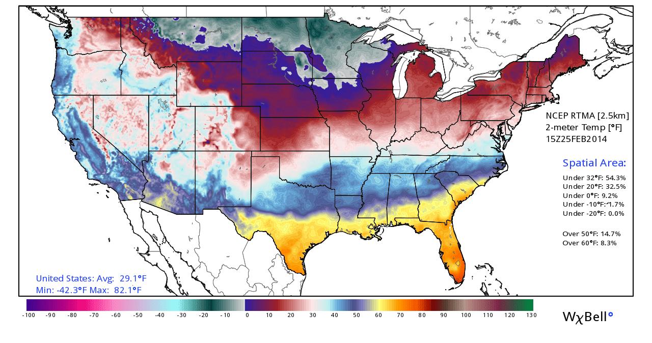
Temperatures @ 2 PM MST Today. Forecast Temperatures @ 5 AM MST Saturday. Today marks the last day of the 2013-2014 meteorological winter. As of 2 PM MST temperatures ranged from 91F in south Texas to -26F in southern Canada. That's a temperature spread of 117-degrees . Saturday marks the beginning of the meteorological spring. According to the RAP computer forecast model temperatures at 5 AM MST tomorrow morning will range from 81F in south Texas, to a bone chilling -61F in southern Canada. That will be an incredible temperature spread of 142-degrees! Welcome to spring folks. The Truth Is Stranger Than Fiction! My Web Page Is Best Viewed With Google Chrome.
GFS Temperature Forecast. Valid @ 5 PM MST Saturday. An amazing temperature contrast will exist along and behind the arctic cold front on Saturday. Temperatures Saturday afternoon will vary from the 80's across southeastern New Mexico and west Texas to -25F in North Dakota. At least a 110-degree difference between the two air masses separating the frontal boundary. The Truth Is Stranger Than Fiction! My Web Page Is Best Viewed With Google Chrome.
Temperatures @ 3 PM MST Today. A colder airmass lies banked up along and east of the central mountain chain of New Mexico at 3 PM MST. Its 20-degrees colder in Roswell than it is in Alamogordo. Arctic Air Invades The U.S. This Weekend. Today's 18Z/11 AM MST GFS Temperature Anomaly Forecast. Valid @ 5 PM MST Saturday. Today's 18Z/11 AM MST GFS Temperature Forecast. Valid @ 5 PM MST Saturday. Today's 18Z/11 AM MST GFS Temperature Forecast. Valid @ 5 PM MST Saturday. Today's 18Z/11 AM MST GFS Wind Chill Forecast. Valid @ 5 PM MST Saturday. Our latest National Weather Service forecast high temperature for Carlsbad , New Mexico on Saturday is 85 . Compare this to temperatures as cold as -15F in Montana with wind chill values down to -35F . That's a 100-degree temperature difference! Id say that we ought to consider ourselves pretty lucky given the fact that its still February. The Truth Is Stranger Than Fi...
Temperatures @ 8 AM MST This Morning. A cold front slipped into southeastern New Mexico earlier this morning. This front will stall over the area today with a stronger surge of colder arctic air arriving tonight. Most of us will see high temps today in the 50's to near 60. Forecast Temperatures. This Mornings 12Z/5 AM MST NAM-WRF Forecast Temps. Valid @ 4 PM MST This Afternoon. This Mornings 12Z/5 AM MST NAM-WRF Forecast Temps. Valid @ 7 AM MST Tomorrow. This Mornings 12Z/5 AM MST NAM-WRF Forecast Temps. Valid @ Noon MST Tomorrow. Slight Chance Of Wintry Mix Tonight Into Tomorrow. This Mornings 12Z/5 AM MST GFS Precipitation Type Forecast. Valid @ 11 PM MST Tonight. This Mornings 12Z/5 AM MST GFS Precipitation Type Forecast. Valid @ 5 AM MST Tomorrow. This Mornings 12Z/5 AM MST GFS Precipitation Type Forecast. Valid @ 11 AM MST Tomorrow. Special Weather Statement. ...
Temperatures @ 4 PM MST. We've experienced yet another day in February with temps in the 70's here in southeastern New Mexico and nearby areas. But if you take a look at the current temperatures maps posted above you can easily see that an arctic cold front is draped across northeastern Colorado, and extends southeastern into northern Texas. Cold Front Arrives Tuesday Night. 18Z/11 AM MST NAM-WRF Temperature Forecast. Valid @ 2 PM MST Wednesday. This cold front will work its way southward and westward into southeastern New Mexico Tuesday night into Wednesday morning. Much colder air will overspread the area on Wednesday with most of us not getting out of the 40's for highs. Slight Chance For A Wintry Mix. Today's 18Z/11 AM MST GFS Precipitation Type Forecast. Valid @ 5 AM MST Wednesday. Today's 18Z/11 AM MST GFS Precipitation Type Forecast. Valid @ 11 AM MST Wednesday. Low clouds and perhaps an area ...
Blog Updated @ 9:25 AM MST Monday, Feb 24, 2014. Looking West At 12,003' Sierra Blanca Peak Ruidoso, New Mexico. Looking Northeast At 12,003' Sierra Blanca Peak From Tularosa, New Mexico. Looking Northeast At Sierra Blanca Peak From Near Apache Summit. Grindstone Lake Southwest Of Ruidoso, New Mexico. Ski Apache has only received 45" of snow thus far this season with 15" on the ground at mid-mountain. Their average seasonal snowfall is 200+ inches. Just another testament of the affects of the ongoing drought. The Truth Is Stranger Than Fiction! My Web Page Is Best Viewed With Google Chrome.
Peak Wind Gusts Yesterday. Low Temps This Morning. We Are Not Done With Winter - More Cold Next Week. Last Nights 00Z/5 PM MST GFS Temp Forecast. Valid Next Wednesday, February 26, 2014. Other than the blustery conditions with the wind, blowing dust, and cooler temps yesterday's weather wasn't so bad. Our brief cool down will end starting today. We can expect to see our afternoon temps climb back into the 70's into the weekend. Saturday will be the warmest day over the next week with most of the southeastern New Mexico plains reaching the low-mid 80's. Winter is not over with by a long shot. Another blast of arctic air will invade the northern plains early next week and by mid-week will have worked its way south into our next of the woods. The Truth Is Stranger Than Fiction! My Web Page Is Best Viewed With Google Chrome.
Severe Weather Outbreak Today. NWS Storm Prediction Centers Day 1 Severe Weather Outlook. Severe weather is forecast today from the Ohio Valley to the Central Gulf Coast. Squally line thunderstorms are forecast to produce damaging winds. A few tornadoes will also be possible. A bit on the unusual side for February. Snow Cover. Only 32% Of The Nation Has Snow On The Ground. Temperatures At 6 AM MST This Morning. Once again its fairly easy to see that a cold front is sliding southeastward across the area. Yesterday's High Temperatures. Today Will Be Cooler. 12Z/5 AM MST WRF Temp Forecast. Valid @ 3 PM MST This Afternoon. This morning is going to be a little bit on the windy side with northwesterly winds gusting up to around 25-35 mph behind the cold front. Higher gusts will be encountered in the Guadalupe, Sacramento, and Capitan mountains. A High Wind Warning remains in effect until 10 AM MST for the Ruidoso area for ...


