My Current Weather

Monday, April 28, 2014

Mayflower & Vilonia, Arkansas Tornadoes 4-27-2014.
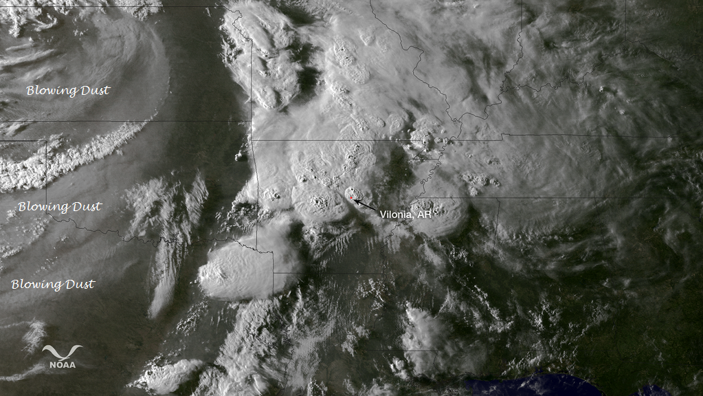

Blog Updated @ 12:13 PM MDT.


@NOAASatellites  
GOES image from 2345Z, Apr 27, an hour before tornado reports from Mayflower and Vilonia, Ark.


GRLevel3 2.00 Snapshots.


Several debris balls were noted with these tornadoes on radar as they tore through west-northeast of Little Rock, Arkansas last night. A debris ball occurs when a large tornado picks up a large number of objects on the ground and lofts them into the air. 

May 27, 2014 Arkansas Tornadoes.


In the picture: Rotation associated with the parent storm on 04/27/2014 was persistent for roughly 40 miles (Tornado #1) before weakening (where the gap is indicated). Another tornado (Tornado #2) was likely spawned a short time later by the same storm and tracked through White, Jackson, and Independence Counties. Note: Tornado #2 may actually be several tornadoes. This will be determined through damage surveys. The graphic is courtesy of the National Severe Storms Laboratory.


In the pictures: The WSR-88D (Doppler Weather Radar) showed strong rotation between Mayflower and Vilonia (both in Faulkner County) at 738 pm CDT on 04/27/2014. There was also a debris ball present, which is a very good indicator of a tornado causing damage.

While this did not turn into an outbreak of severe weather, the ferocity of at least one storm was realized. Just after 700 pm CDT, a supercell (storm with rotating updrafts) rapidly intensified northwest of the Little Rock (Pulaski County) area. A destructive tornado was produced, with the tornado tracking through Mayflower and Vilonia (both in Faulkner County) before apparently dissipating (according to radar) near El Paso (White County).

Mayflower, Arkansas 4-27-2014.

Three RVs entwined in a metal billboard sign near I-40 in Mayflower. 
Courtesy Of Justin Lewis: 

Better wide view of tornado damage in Mayflower and what's left of a local business.
Courtesy Of Justin Lewis:

Another shot of piled up cars at Mayflower RV from Sunday tornado.
Courtesy Of Justin Lewis:

American flag in the storm rubble in Mayflower, AR  Courtesy Of Maria Molina.

Vilonia, AR: RT : Von Lee and his family road out the storm in their cellars.
They came out to this.

New pics from courtesy of after

New pics from courtesy of after  

Fox News is reporting this morning (As of 9 AM MDT) that at least 18 people were killed in yesterday's tornadoes, 16 of those in Arkansas. Fox16 in Little Rock, Arkansas is reporting that at least 100 people are being treated for their injuries from the tornadoes. 

The Truth Is Stranger Than Fiction! 

 My Web Page Is Best Viewed With Google Chrome.

Sunday, April 27, 2014

Sunday, April 20, 2014

Cumulonimbus Mammatus Clouds Over SE NM.


 Cumulonimbus Mammatus (CBMAM) Northeast Of Carlsbad, 
New Mexico Yesterday Afternoon.

Cumulonimbus Mammatus South Of Artesia, New Mexico Yesterday.

(As Of 6 AM MDT.)


Estimated Rainfall Totals Using GRLevel 3 2.00.


Although the bright yellow and orange shaded areas indicate that widespread rainfall amounts of 1.00" to 2.00" fell across much of Eddy County New Mexico yesterday, these radar estimated rainfall totals are too high. Based on actual measurements across the local area it appears that the radar was overestimating the rainfall totals by up to 1.50".  

The good news is that widespread rainfall totals of around .25" were noted with some locations getting more than .50". I measured .58" here at our home in Carlsbad. A National Weather Service employee measured 1.56" of rainfall 10 miles north-northeast of El Paso yesterday afternoon. 

The Truth Is Stranger Than Fiction! 

 My Web Page Is Best Viewed With Google Chrome.

Saturday, April 19, 2014

After The Rain.


Ash Tree In Our Front Yard.

The Truth Is Stranger Than Fiction! 

 My Web Page Is Best Viewed With Google Chrome.

Round One Produces Light Rainfall.


24-Hour Rainfall Totals.
(Ending @ 7 AM MDT This Morning).


The Truth Is Stranger Than Fiction! 

 My Web Page Is Best Viewed With Google Chrome.

Tuesday, April 15, 2014

Monday, April 14, 2014

Brrrrr.


Lows Reported This Morning.


Peak Wind Gusts Overnight.


A much colder airmass overspread the state overnight as a strong late season cold front blasted south. Arteisa reported a wind gust of 58 mph at midnight as the front moved through and Carlsbad reported a wind gust of 56 mph.

Widespread blowing dust accompanied the frontal passage and then light snow was reported in Roswell between 5 and 6 am.

The Truth Is Stranger Than Fiction! 

 My Web Page Is Best Viewed With Google Chrome.

Sunday, April 13, 2014

Strong Cold Front Tonight - Late Season Free Tuesday Morning.


A strong late season cold front had entered northeastern New Mexico as of 4 PM MDT. Gusty northerly winds were accompanying the front passage along with falling temps. Widespread 20's and 30's were noted across the eastern side of Colorado.


Tonight @ Midnight.

 Monday Morning @ 8 AM MDT.

Monday Afternoon @ 3 PM MDT.

Tuesday Morning @ 6 AM MDT.

Get read for a big temperature drop behind the cold front tonight as it moves south into the local area. The front will be entering the northern sections of southeastern New Mexico by around midnight, and then will have moved south of the state line by sunrise tomorrow morning.

Strong northerly winds sustained at around 25 - 35 mph with gusts up to around 55 mph will accompany the frontal passage tonight. A Wind Advisory is in effect from midnight tonight through 6 AM MDT tomorrow morning.

Areas of blowing dust will also be possible tonight into tomorrow morning as the front blows south. Some locations may see drops in the visibility down to less than one mile, especially over and near some of our dust prone locations such as open or freshly plowed fields, exposed lots, and construction sites.

Monday will be much colder with most of us seeing highs in the 40's and 50's. Believe it or not but a freeze is anticipated by Tuesday morning as our low temps drop down below freezing. Some of us may even see lows in the 20's. 


A Winter Weather Advisory continues in effect for parts of northern and northeastern New Mexico through noontime tomorrow for snow and blowing snow. Some locations in northeastern New Mexico are expecting to get up to 2" - 4" of snow, while parts of the Sangre De Cristo mountains are expecting 4" - 8".

The Truth Is Stranger Than Fiction! 

 My Web Page Is Best Viewed With Google Chrome.

NWS Albuquerque Burn Scar Matrix Forecast

Current NWS Watches/Warnings In Effect

New Mexico

Eddy County

Chaves County Plains & Mtn's

Culberson County

Lea County

Lincoln County

Otero County

Current US Temps

Current US Wind Chill/Heat Index Temperatures

NWS Midland Forecast

NWS Albuquerque Forecast

NWS Albuquerque Forecast

NWS El Paso Forecast

NWS Lubbock Forecast

NWS Lubbock Forecast

Average Daily High/Low Temperatures & Rainfall

Average Daily High/Low Temperatures & Rainfall