

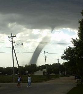
Carlsbad, New Mexico Landspout Tornadoes - May 29, 2025.


Carlsbad, NM Landspout Tornadoes 5 29 2025

At 310 PM MDT, a severe thunderstorm was located near Carlsbad, moving northeast at 10 mph.
HAZARD...60 mph wind gusts and quarter-size hail.
SOURCE...Public reports of a landspout near the city of Carlsbad.
IMPACT...Hail damage to vehicles is expected. Expect wind damage to
roofs, siding, and trees.
Locations impacted include... Carlsbad, Carlsbad North, Otis, Cavern City Air Terminal, and Living Desert State Park.
PRECAUTIONARY/PREPAREDNESS ACTIONS...
For your protection, move to an interior room on the lowest floor of a building.
&&
/O.NEW.KMAF.SV.W.0296.250529T2053Z-250529T2200Z/
BULLETIN - IMMEDIATE BROADCAST REQUESTED
Severe Thunderstorm Warning
National Weather Service Midland/Odessa TX
253 PM MDT Thu May 29 2025
The National Weather Service in Midland has issued a
* Severe Thunderstorm Warning for...
East central Eddy County in southeastern New Mexico...
* Until 400 PM MDT.
* At 253 PM MDT, a severe thunderstorm was located over Carlsbad,
moving east at 10 mph.
HAZARD...60 mph wind gusts and quarter-size hail.
SOURCE...Radar indicated.
IMPACT...Hail damage to vehicles is expected. Expect wind damage
to roofs, siding, and trees.
* Locations impacted include...
Carlsbad, Avalon, Carlsbad North, Lake Avalon, Otis, Cavern City
Air Terminal, and Living Desert State Park.
PRECAUTIONARY/PREPAREDNESS ACTIONS...
For your protection, move to an interior room on the lowest floor of a
building.
&&
LAT...LON 3230 10431 3248 10435 3258 10389 3232 10384
TIME...MOT...LOC 2053Z 253DEG 10KT 3238 10422
HAIL THREAT...RADAR INDICATED
MAX HAIL SIZE...1.00 IN
WIND THREAT...RADAR INDICATED
MAX WIND GUST...60 MPH
348
NWUS54 KMAF 292114
LSRMAF

Preliminary Local Storm Report
National Weather Service Midland/Odessa TX
414 PM CDT Thu May 29 2025

..TIME...   ...EVENT...      ...CITY LOCATION...     ...LAT.LON...
..DATE...   ....MAG....      ..COUNTY LOCATION..ST.. ...SOURCE....
            ..REMARKS..

0305 PM     Landspout        1 NW Loving at Hwy 285  32.30N 104.11W
05/29/2025                   Eddy               NM   Trained Spotter

            Spotter reported landspout west of Loving,
            NM.


&&

$$
311
NWUS54 KMAF 292340
LSRMAF

Preliminary Local Storm Report
National Weather Service Midland/Odessa TX
640 PM CDT Thu May 29 2025

..TIME...   ...EVENT...      ...CITY LOCATION...     ...LAT.LON...
..DATE...   ....MAG....      ..COUNTY LOCATION..ST.. ...SOURCE....
            ..REMARKS..

0410 PM     Tstm Wnd Dmg     1 NNE Carlsbad          32.42N 104.23W
05/29/2025                   Eddy               NM   Public

            Multiple tree branches down near Main Street
            on the east side of Carlsbad due to
            thunderstorm wind gusts.


&&

$$

KML
Landspout
Tornadoes are of various types like waterspouts, snowspout, multi vortex tornadoes but have you ever heard about Landspouts tornadoes. This article will discuss about Landspout tornadoes, their formation, and what damages they cause to the environment.
In 1985, a meteorologist named Howard B. Bluestein coined the name “Landspout.” Landspouts are similar to waterspouts in their mechanism and resemblance. That is the reason so many people get confused in differentiating a Landspout tornado from a waterspout tornado. They both include in the category of tornadoes. However, there are specific characteristics that distinguish Landspout from other tornadoes. As it gets clear from its name that it emerges near the land or surface where the winds are converging. These tornadoes have flat bases and fluffy, cotton-like appearance.
How are Landspout Tornadoes Formed?
In the formation, Landspouts are similar to waterspouts except they occur over the land surface. They also formed when there is no sign of a thunderstorm. Not all Landspouts are visible to people. Moreover, Landspouts are thin, and rope-like in appearance instead of funnel shape like waterspouts does. People often confused Landspouts with other tornadoes. A Landspout classified as a tornado type but certainly, it is different from a tornado. For example, Tornadoes are made up from supercell thunderstorms. The thunderstorms have mesocyclones, which are rotating updrafts. They are strong enough to stretch inside a thunderstorm, a spinning column of air that can reach the Earth surface. Once it makes contact on the ground, a tornado forms. Whereas, a Landspout is not made up of supercell thunderstorms. The convergence of surface boundaries and thunderstorm updraft forms the circulation. The circulation then pulled it in an upward direction to the base of the thunderstorm. In simple words, the tornado always formed from top to down, funnel cloud goes down to the ground but the Landspout always formed as the bottom up. When there is a converging air on the sides of the boundary, Landspouts starts forming.
Duration of Landspout Tornado
Landspout is not a long duration tornado that destroys everything that comes in their way. Landspout is a weak tornado that lasts only for fifteen minutes and not more than that.
What Damages it Causes
Although Landspout does not have powerful winds, but it causes damages to possessions and things. This damage may not be severe, but it exists. Another reason due to which it does not cause severe damages is that they formed far from the ground level. According to the EF (Enhanced Fujita) scale reading, Landspouts are usually at EF0 level where the intensity of winds is low and weak. However, winds inside a Landspout tornado can reach 100 miles per hour (MPH). Landspout Tornado is difficult to cast, and Doppler weather radar cannot detect them. That is why the forecast is difficult, and there is no time for warning.
When do Landspout Tornadoes Occur
There is no fixed time of occurrence of tornadoes because they could emerge at any time in the year and may surprise you. Landspouts are hard to see because in most of the cases they are invisible. One can see a Landspout or could guess its presence when the dirt and dust are getting up in the air due to this tornado. Typically, spring and summer months are ideal for Landspouts. So be prepared during these months of the year.
Safety Measures
Although Landspout Tornado is not dangerous, safety measures are essential if you encounter one. Do not go near the windows of your house because the wind will break the glass and it can wound you severely. Get shelter inside a basement or firm shelves. For those who do not have a basement in their homes, hide inside a bathroom or room which has thick walls.


| Part of a series on |
| Weather |
|---|
Landspout is a term created by atmospheric scientist Howard B. Bluestein in 1985 for a tornado not associated with a mesocyclone.[3] The Glossary of Meteorology defines a landspout as:[4]
Landspouts are typically weaker than mesocyclone-associated tornadoes spawned within supercell thunderstorms, in which the strongest tornadoes form.
Characteristics
[edit]Landspouts are a type of tornado that forms during the growth stage of a cumulus congestus or occasionally a cumulonimbus cloud when an updraft stretches boundary layer vorticity upward into a vertical axis and tightens it into a strong vortex.[5] The parent clouds are often predominantly liquid when producing landspouts.[6] Landspouts can also occur due to interactions from outflow boundaries, as they can occasionally cause enhanced convergence and vorticity at the surface. These generally are smaller and weaker than supercell tornadoes and do not form from a mesocyclone or pre-existing rotation in the cloud. Because of this lower depth, smaller size, and weaker intensity, landspouts are rarely detected by Doppler weather radar.[5]
Landspouts share a strong resemblance and development process to that of waterspouts, usually taking the form of a translucent and highly laminar helical tube. "They are typically narrow, rope-like condensation funnels that form while the thunderstorm cloud is still growing and there is no rotating updraft", according to the National Weather Service.[2] Landspouts are considered tornadoes since a rapidly rotating column of air is in contact with both the surface and a cumuliform cloud. Not all landspouts are visible, and many are first sighted as debris swirling at the surface before eventually filling in with condensation and dust.
Orography can influence landspout (and even mesocyclone tornado) formation. A notable example is the propensity for landspout occurrence in the Denver Convergence Vorticity Zone (DCVZ).
Life cycle
[edit]Forming in relation to mesocyclones and under updrafts, a landspout generally lasts for less than 15 minutes; however, they can persist substantially longer, and produce significant damage. Landspouts tend to progress through recognizable stages of formation, maturation, and dissipation, and usually decay when a downdraft or significant precipitation (outflow) occur nearby. They may form in lines or groups of multiple landspouts.[7]
Damage
[edit]Landspouts are usually at EF0 level where the intensity of winds is low and weak. However, winds inside a landspout tornado can reach 100 mph (160 km/h).[8]


Comments
Post a Comment
Your comments, questions, and feedback on this post/web page are welcome.