My Current Weather

Tuesday, August 29, 2017

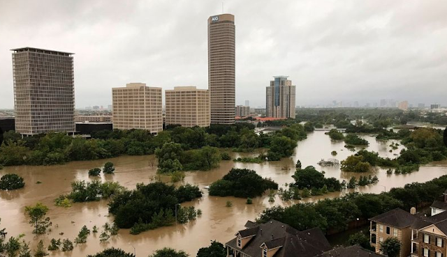
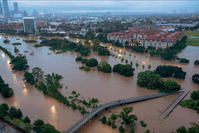
Houston's Heroes Make America Who We Are!


This Is What Makes America Who We Are!


Houston Police Sergeant Steve Perez a 34 year veteran of the force lost his life today in the flooding in Houston. Officer Perez drowned in his car while on his way to work early this morning. News reports are stating that his family begged him not to go but his response was "I have work to do." Officer Perez refused to stay home while so many in his city were in need and answered that call for help one last time.

Nobody wants to lose a family member and loved one like this. Officer Perez's death is tragic and our hearts and prayers go out to his family and community. His life and death remind us that this is what America and Texas is, this is who we are!

John 15:13-

Jesus said: Greater love hath no man than this, that a man lay down his life for his friends. God rest your soul Officer Perez and thank you for your love and service to your community, your friends.


A Day Of Historic Rainfall - The 1,000 Year Event.


Houston Prays And Hangs On Tonight As The Flooding Rages On.

Darkness is settling in over the nations fourth largest city as the end of the rains are in sight but not the Catastrophic Life-Threatening Flooding. Another day of countless rescues as more neighborhoods are flooded and people are driven from their homes. How many have suffered is unknown. The devastation is describable and unthinkable. Houston and Texas will recover but its going to take time.

The Truth Is Stranger Than Fiction!

Monday, August 28, 2017

Houston Is Drowning One Neighborhood At A Time.

Downtown Houston This Morning.


Valid At 4:18 PM MDT This Monday Afternoon.

Note that swirl in the middle of the image. That's not what you want to see which means that Harvey has developed a closed circulation again. The latest National Hurricane Center (NHC) Advisory at 3 PM MDT Harvey is very slowly strengthening. He now has sustained winds of 45 mph with a central pressure of 994 millibars or 29.44 inches of mercury. Harvey was located just south of Matagorda moving slowly to the east-southeast at 3 mph. 


Harvey is currently forecast to gain some strength but not obtain Hurricane status before looping back to the northeast and making landfall near the Galveston area by Wednesday. Lets hope the computer model forecasts are right and this is how he plays his cards between now and then. The worst thing that could happen is that he stalls again over the warmer waters of the Gulf to the east of his present location and strengthens back into a Hurricane.


24-Hour & 72-Hour Rainfall Totals.

Harvey's rainfall has simply been incredible! As of 3:39 PM CDT this afternoon the heaviest rainfall total I could find in the past 24-hours rainfall was the 18.35" 1.0 miles north-northeast of Katy in Harris County. 

The highest storm total so far that I could come up with (past 72 hours) as of 3:29 PM CDT this afternoon was the 36.34" measured 4 miles west-southwest of First Colony in Fort Bend County.

Storm totals as estimated by radar in the Houston area indicate that nearly 40" has already fallen and that was as of this morning.

The Houston Intercontinental Airport set a new 24-hour rainfall record yesterday with 16.07" which beat the previous record of 8.32" set in 1945.

The greatest 72-Hour total I could come up with via the CoCoRaHAS web site in Harris County was CoCoRaHAS Station (TX-HRR-223) 5.6 miles north-northwest of Mission Bend.

(As Of 6 AM MDT This Morning).


(Tonight Into Tuesday).


Sadly another additional 4 to 12 inches of rain is forecast to fall tonight into Tuesday on top of what has already fallen over the past four days. Houston is simply slowly drowning one section of the city at a time. Rivers, streams, creeks, bayous, and lakes in the area simply cannot hold any more runoff from the torrential rainfall. Many are already way out of their banks. Local officials begin releasing flood waters from some of the lakes in the area today hoping to spare the downtown area of Houston but all the while flooding additional neighborhoods in the process. There just isn't anywhere for the water to go as it continues to come down in buckets from the sky, deepen, and spreads across the city and surrounding countryside.

Harris County Flood Warning System.


This map shows the rivers, creeks, and bayous that are flooded as of 4 PM MDT this afternoon. The map is interactive so click on the link above to get the latest updated information. The red dots indicate flood waters that are out of rivers, creeks, and bayou banks. 


As of 4 PM MDT 67 of Houston's 121 river flood gauges were in flood stage.

East Fork San Jacinto River Near Caney.


A case in point is the East Fork of the San Jacinto River near Carney northeast of Houston. The flood gauge was showing a level in the river of 77.11 feet! Flood stage is 58 feet. All 22 watersheds in the Houston area are flooded.


Local News Reported That Over 250 Roads Were Closed In The Houston Area This Morning. 


(September 8th, 1900).


A lot of quotes in the news media the last couple of days about Harvey already or will be the worst weather disaster in Texas history. Uh I don't think so. As tragic as Harvey is and potentially will be when its all over with you still can't top the September 8th,1900 Hurricane that drowned 8,000 to 12,000 people in Galveston. 


Headlines From Houston Today.

The Truth Is Stranger Than Fiction!

Sunday, August 27, 2017

Unprecedented Historic Widespread Flooding Continues In Houston Tonight!


NWS Houston/Galveston Doppler Radar Snapshot At 8:42 CDT.


Another 5 to 10 Inches Of Rain Before Midnight!


(Issued At 2:09 PM CDT This Afternoon).


Hard To Image It Will Get Worse But It Will!

Two different "bands" of thunderstorms are developing over southeast Texas now. One basically east of Houston and the other "band" on the west side of the city.Between now and about midnight another 5 to 10 inches of rain is possible in the Houston Metro area! This on top of the 30" that has already fallen last night and today!Additional Flash Flooding and Flooding is forecast to continue past midnight into Monday and Tuesday. Some of which may be Catastrophic and Life-Threatening. Today was bad in the Houston area but tonight has the potential to be much worse!Feel free to share this post with your friends, loved ones, and relatives especially if they live in the affected areas!
National Weather Service Office Houston/Galveston, TX link-

As always current weather conditions, live radar, forecasts, watches, warnings, satellite images, and more are always current and available via my weather web page-


The Truth Is Stranger Than Fiction!

Unprecedented Catastrophic Life-Threatening Flooding Ongoing In Houston, TX Area!


Blog Updated At 12:16 PM MDT.

Flooded Houston, Texas This Morning.


GOES-16 Infrared (IR) Satellite Image Of Tropical Storm Harvey.


Valid At 10:50 AM MDT This Morning.


Red Circles Are Bayous, Rivers, Creeks That Are Flooded Out Of Their Banks.


(Direct Quote From The Houston/Galveston, Texas National Weather Service Office).


24-Hour rainfall totals in Harris County and in and around that area as of 8 AM CDT this morning ranged from around 10 inches to as high as 28 inches! Local Emergency Management Officials are reporting that south Houston has picked up 15 inches of rain in the past 3 hours! Rain was falling at the rate of 3 to 7 inches per hour! Average rainfall for Harris County for the past 24-Hours is nearly 14 inches. National Weather Service forecasts were calling for rainfall totals of up to 35 inches by noontime today.
 Astonishingly another 15 to 25 inches of rain is forecast to fall over this areas over the next five days! Unbelievably the NOAA's Weather Prediction Center (WPC) is forecasting isolated totals of an additional 50 inches! 

Additional actual reported rainfall totals are available via the Texas Harris County CoCoRaHS web page via this link.

Life-Threatening Flooding Catastrophic Unfolding In The Houston, Texas Area.

Over 2,000 calls for rescues have occurred in the Houston area since 9 PM CDT last night. Over 1,000 people have been rescued. Local Emergency Management Officials are asking residents not to seek shelter in their attics but instead get to their roofs if possible. 911 Call Centers are overwhelmed with calls of people pleading for help and rescues. Widespread catastrophic flooding is ongoing and will only get worse with time with the additional rainfall today and over the next couple of days! Dams in the area are becoming stressed and are in danger of being overwhelmed and failing. 

This event will breaks all records for flooding in this area of Texas and could go down in history as the worst flooding event of all-time in Texas! The Unprecedented Life Threatening Catastrophic Flooding that is ongoing in the Houston area will eclipse the flooding event that Tropical Storm Allison produced in 2001.


(Issued At 10:42 AM CDT/9:42 AM MDT).


Harvey Forecast To Re-Emerge Out Into The Gulf Of Mexico.


Valid At 6 PM MDT Monday, August 28, 2017.

The Truth Is Stranger Than Fiction!

NWS Albuquerque Burn Scar Matrix Forecast

Current NWS Watches/Warnings In Effect

New Mexico

Eddy County

Chaves County Plains & Mtn's

Culberson County

Lea County

Lincoln County

Otero County

Current US Temps

Current US Wind Chill/Heat Index Temperatures

NWS Midland Forecast

NWS Albuquerque Forecast

NWS Albuquerque Forecast

NWS El Paso Forecast

NWS Lubbock Forecast

NWS Lubbock Forecast

Average Daily High/Low Temperatures & Rainfall

Average Daily High/Low Temperatures & Rainfall