Posts

Showing posts from August, 2013

Why Are My Weather Posts Missing From Facebook.

Hello everyone. I just wanted to let you know that my Facebook page was shut down without any warning by Facebook this past Saturday, June 8th. All I was told was that I had violated their community standards. I don't know what triggered that; they didn't tell me. I was told this may be permanent or for six months.
My guess is that it may be because I posted several comments and articles from my Substack page about the riots in LA, and that must have triggered/angered someone, and they complained, thus Facebook shut me down. I don't know this as fact, though. I have appealed this decision, and I'm still waiting for their reply. I have read on X that this has happened to other Facebook users posting about the LA riots as well.
I always share my weather blog posts (that I post here) on my Facebook page and my X page. This included over twelve different New Mexico and West Texas Facebook Community sites. So there are thousands of you out there (based on my views and shares of those posts) who will no longer see those posts. My Facebook page may or may not be restored.
This is another good reason (as the National Weather Service often reminds us) to have multiple ways of receiving severe weather alerts when severe weather threatens your location. My weather web page is one of those ways, and I really appreciate all of you who have and still do use it. Thank you so much!!!
If my Facebook page is restored, I will continue to share my weather blog posts and some of the NWS Watches and Warnings...as I have been doing for years now.

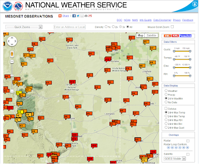
Lordsburg, NM Gets 2.35" Of Rain.

Image
NWS 24-Hour Mesonet Rainfall Totals. Lordsburg, NM Davis WeatherLink Summary. Lordsburg got lucky yesterday evening when a thunderstorm dumped 2.35" of rain on them. Once again most of the rain remained over southern New Mexico and bypassed southeastern New Mexico. Hot dry weather is forecast to continue into at least the first of next week. Courtesy Of The Midland NWS Office. The Truth Is Stranger Than Fiction!   My Web Page Is Best Viewed With Google Chrome.

Southern New Mexico Gets Rain.

Image
Snapshot Of My SE NM Radar. Using Holloman AFB Radar @ 6:19 AM MDT. Radar Estimated Rainfall Totals. Via The El Paso/Santa Teresa NWS Dual Pol Radar Using GRLevel 3.200 Software. Radar Estimated Rainfall Totals. Via The Holloman AFB Dual Pol Radar Using GRLevel 3.200 Software. NWS Mesonet Rainfall Totals As Of 6 AM MDT. It is raining but not in southeastern New Mexico. A hot and dry week ahead is in store for us with our afternoon high temperatures forecast to range from the low 90's to near 100 today into the first of next week. The Truth Is Stranger Than Fiction!  My Web Page Is Best Viewed With Google Chrome.

Latest 10-Day Rainfall Forecasts.

Image
ECMWF 10-Day Total Rainfall Forecast. GFS 10-Day Total Rainfall Forecast. Canadian (GEM) 10-Day Total Rainfall Forecast. Overall the models are not very optimistic when it comes to rainfall for southeastern New Mexico over the next ten days. However, a tropical wave now located over Texas, will move northwestward into southern New Mexico by Wednesday, and this feature will increase our chances for scattered thunderstorms to break out on Tuesday.  With the eastern Pacific now becoming more active with tropical storms, the Atlantic Basin is forecast to do the same, it would not take much of a pattern shift to get the monsoon to swing back further to the east, and bring some more rainfall back into the area. So this will have to be watched in the coming weeks. The Truth Is Stranger Than Fiction!   My Web Page Is Best Viewed With Google Chrome.

Sunset.

Image
Another stellar New Mexico sunset this evening. The Truth Is Stranger Than Fiction!   My Web Page Is Best Viewed With Google Chrome.

Our Nights Are Slowly Getting Cooler.

Image
NWS Mesonet Low Temps As Of 6:30 AM MDT. The Truth Is Stranger Than Fiction!  My Web Page Is Best Viewed With Google Chrome.

Good Morning Southeastern New Mexico.

Image
The Truth Is Stranger Than Fiction!  My Web Page Is Best Viewed With Google Chrome.

ECMWF Forecasting A Better Chance For Rain Down The Road.

Image
 ECMWF 10-Day Total Rainfall Forecast. ECMWF 24-Hour Rainfall Forecast. Valid @ 6 PM MDT Sunday, August 25, 2013. ECMWF 10-Day Max Temp Anomaly. Valid @ 6 PM MDT Sunday, August 25, 2013. ECMWF 850 MB MSLP Forecast. Valid @ 6 AM MDT Saturday, August 24, 2013. Every once in awhile a Hurricane will form south of the Baja Penisula, work its way northward, and sometimes spread its remnant moisture into our neighborhood. This mornings run of the European (ECMWF) computer model is forecasting just such an event in about a week from this coming Sunday.  Notice its forecast of much cooler temps, and widespread moderate to heavy rains on Sunday, August 25th via the maps posted above. Will this pan out...maybe, maybe not. I'm sorry but its just a tad early to know for sure so we will just have to wait and see. The Truth Is Stranger Than Fiction!   My Web Page Is Best Viewed With Google Chrome.

Another Day Of 100-Degree Temps.

Image
NWS Mesonet High Temperatures Reported Sunday. For the most part August has been fairly hot and dry over southeastern New Mexico. Contrast this with July which was a cool and wet month for the local area. So far this month I've only manged to squeeze .10" out of my rain gauge here at my home in Carlsbad. Today will be another day with afternoon high temps in the upper 90's to the low 100's.  The Truth Is Stranger Than Fiction!   My Web Page Is Best Viewed With Google Chrome.

If Only I Could Reach The Moon.

Image
The Truth Is Stranger Than Fiction!  My Web Page Is Best Viewed With Google Chrome.

Invest AL92 Over The Yucatan Peninsula - Future Of Storm Highly Uncertain.

Image
Courtesy Of The NHC. IR Satellite Image @ 12:15 PM MDT. Model Forecast Tracks Of Invest AL92. Valid @ 6 AM MDT Monday. Valid Today Through 6 AM MDT Saturday. Valid @ 6 AM MDT Sunday. With out a doubt the models are really struggling with the easterly wave that is currently located over the Yucatan Peninsula. Since this wave is over land now, and highly disorganized, the models are simply all over the place with their forecasts concerning this system. None of them appear reliable at this time in my opinion.  Yesterday I thought that this system would be named Erin but that's not to be. Tropical Storm Erin has formed about 115 miles west-southwest of Brava, in the Cape Verde Islands. Erin will generally continue moving westward for the next several days. For now, I won't focus much on this system since it will not be impacting the U.S. mainland anytime soon, if at all. Back to our storm that is forecast to enter...

Trouble In The Gulf Of Mexico - Or Will Invest AL92 Be A Dud?

Image
Blog Updated At 2:15 PM MDT Today. Tropical Disturbance Invest AL92.  An area of disturbed weather located northeast of the tip of Honduras and the Cayman islands may now be forming a surface low. This tropical disturbance has a 50% change of becoming a tropical storm within 48 hours, and a 60% chance of becoming a tropical storm within the next five days. It is likely to continue moving off towards the northwest towards the Yucatan Peninsula over the next couple of days and then is expected to enter the Gulf of Mexico by this weekend.  IR Funktop Image @ 9:15 AM. MDT This Morning. Invest AL92 Model Track Forecasts. Canadian Computer Model Forecast Of Invest AL92. Valid @ 6 AM MDT Friday Morning. Valid @ 6 AM MDT Saturday Morning. Valid @ 6 AM MDT Sunday Morning. Valid @ 6 AM MDT Monday Morning. Valid @ 6 AM MDT Tuesday Morning. Valid @ Midnight Tuesday, August 20, 2013. Trou...

NWS Albuquerque Burn Scar Matrix

Current National Weather Service Watches/Warnings In Effect.

New Mexico

Chaves County Plains & Mtn's

Eddy County

Culberson County

Lea County

Lincoln County

Otero County

Current US Temps

Current US Wind Chill/Heat Index Temperatures

WPC 7-Day Precipitation Forecast

Roswell Live EarthCam

Ruidoso Live Webcam

Cloudcroft Live Webcam

NWS Midland 3-Day Precipitation Forecast

NWS Midland High End 3-Day Precipitation Forecast

NWS Midland 3-Day Precipitation Chances

New Mexico 3-Day Precipitation Forecast

New Mexico 3-Day High End Precipitation Forecast

New Mexico Precipitation Chances

NWS El Paso 3-Day Precipitation Forecast

NWS El Paso High End 3-Day Precipitation Forecast

NWS El Paso 3-Day Precipitation Chances

US 24-Hour Precipitation Forecast

US 3-Day Precipitation Forecast

US 24-Hour Snowfall Forecast

US 3-Day Snowfall Forecast