My Current Weather

Tuesday, June 26, 2018

Isolated T-Storms But Still Very Hot This Week.


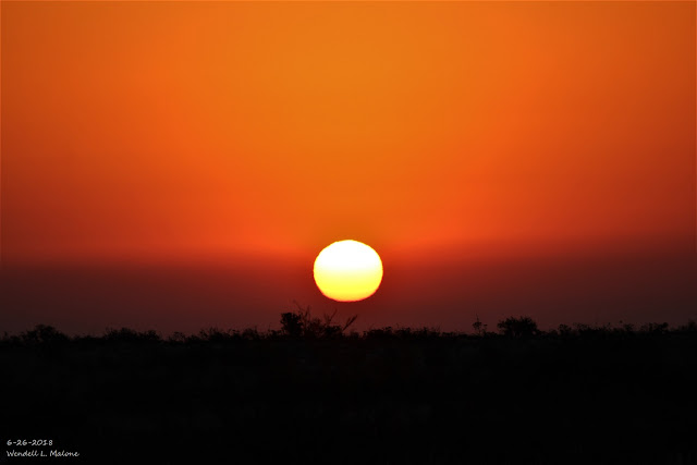
June 26th, 2018.

This hazy, somewhat smokey, dusty sunrise I captured from just south of Whites City this morning pretty much sums up our weather of late. A cold front blew through the Southeastern Plains early Monday morning producing northerly wind gusts to 65 mph at the Bat Draw Raws located at the Carlsbad Caverns Visitor Center and 52 mph at an automated weather station in southwestern Carlsbad.

The weak cold front brought brief relief from the excessive heat yesterday. My high temp recorded here at our home in Carlsbad was only 95.2º, down from 108.5º on Sunday and 105.1º on Saturday. I said brief because as of 3:50 PM MDT this Tuesday afternoon I've already managed to climb back up to 102.6º this afternoon. Triple digit highs are forecast for the rest of this work week. 

Meanwhile the Crooked Creek Fire currently burning along the east slopes of the northern Guadalupe Mountains some 20 miles southwest of Hope, and 30 miles west of Lakewood is now 40% contained. It has scorched some 6,800 acres so far and was started by dry lightning on June 15th. This isn't the only Forest Fire currently burning in New Mexico. Visit this site "New Mexico Fire Information" for a list of current fires and those of this spring and early summer thus far.

The Heat Is Back.


Finally Some Rumbles Of Thunder.

June 26th, 2018.

Coming home from work this afternoon I captured this thunderstorm over the Guadalupe Mountains. Notice the Cumulonimbus Mammatus Clouds. This storm was dumping moderate to heavy rains in the Queen area. As of 4 PM the Queen Raws was reporting .21" of rainfall, the Dog Canyon Raws southwest of Queen .05", and both the Bowl Raws and Pine Springs .01". That's not much rain but its a start and sure beats nothing at all. Notice the Cumulonimbus Mammatus Clouds. 


Valid At 4 PM MDT. 

(As Of 4 PM MDT


This storm was dumping moderate to heavy rains in the Queen area. As of 4 PM the Queen Raws was reporting .21" of rainfall, a Personal Weather Station (PWS) in Weed reported .08", the Dog Canyon Raws southwest of Queen .05", and both the Bowl Raws and Pine Springs .01". That's not much rain but its a start and sure beats nothing at all. 

(Valid As Of 8 AM MDT Tuesday, June 26, 2018).


(Valid As Of 8 AM MDT Tuesday, June 26, 2018).


December 28th, 2017 - June 25th, 2018).


This mornings run of the European (ECMWF) forecast model keeps us in the oven through the rest of this week into the first of next week with near to above triple digit high temps across the Southeastern Plains. Its not very hopeful at all for wetting rains either. The GFS model seems too wet so the truth may lie in between the two models. Isolated to scattered thunderstorms will be possible especially this weekend with the best chance for getting wet being over and near the mountains. 

(June 24th -3th, 2018).


The Truth Is Stranger Than Fiction!

Saturday, June 23, 2018

Hot Through The Near Term!


Yesterday's high temperature of 107º here at our home in Carlsbad marks the third time this year we've reached that reading. My highest so far though was 108º set on June 1st.

Changes To Davis Weather Stations.

Davis Weather is undergoing changes in how we are able to display our Personal Weather Station data to the world. Click on this link to view the new map of their Personal Weather Stations (PWS). The old map of their Personal Weather Stations is still up. I've already moved my Davis Vantage Pro2 Home Weather Station over to the new API setup. They have published a YouTube Video with instructions on how to do this via this link.


Valid At 9 AM MDT This Saturday Morning.

We are starting to broil early as temperatures along and south of the New Mexico and Texas State line have already climbed up into the 90's as of 9 AM. 


Forecast high temperatures today across Southeastern New Mexico and parts of West Texas are expected to be in the 105º to 113º range.


Locally the Roswell Airport recorded the highest temperature with a reading of 109º. Carlsbad's Airport reported a high temp of 107º, and the Artesia Airport 106º. A few new daily record high temperatures may be equaled or exceeded over the next few days.


Today.


Sunday.


Last nights run of the ECMWF computer forecast model offers little hope for relief locally and keeps us at or above 100º for the next ten days. Our hope for relief lies in the onset of our annual summer Monsoon which typically begins around the first of July in New Mexico. Click on this link for the latest briefing from the Albuquerque National Weather Service Office concerning this. 

The Truth Is Stranger Than Fiction!

Tuesday, June 19, 2018

Triple Digit Temps Return!

June 16th, 2018.

Looking northeast from my mother's and brother's alfalfa farm in Atoka, south of Artesia this past Saturday at a long line of thunderstorms along the New Mexico and Texas State line. For those of you who managed to get a decent rain out of this storm I hope you enjoyed because that is over for awhile. 

Most of you are not going to like what is coming back...you guessed it, triple digit afternoon high temperatures. In fact the European forecast model (ECMWF) gets kinda of crazy and is forecasting a high temperature this coming Saturday of 111º for Carlsbad! The GFS and National Weather Service (NWS) NDFD forecasts aren't far behind with a forecast high of 109º. So who is splitting hairs right? 

Thursday marks the beginning of the calendar summer and listed below are some of our local daily record high temperatures for June 21st. It does not appear that we will reach these records on Thursday by the daily records for Saturday may be threatened.

Roswell Climate 109º in 1981
Artesia Climate 108º in 1935
Carlsbad Climate 110º in 1942
Carlsbad Airport 109º in 1996
Hobbs Climate 110º in 1960
Tatum Climate 110º in 1981

Bottom line is its going to be hot with near record to record high temperatures forecast!


Wednesday.


Thursday.


Friday.


Saturday.


Sunday.


European (ECMWF) Forecast High Temps.


GFS Forecast High Temps.


We could be in Death Valley, California where the forecast high temperature on Thursday is expected to approach 125º. An Excessive Heat Warning is in effect for the area through this weekend. 

The Truth Is Stranger Than Fiction!

Sunday, June 17, 2018

24-Hour Rainfall Totals.


June 16th, 2018.

Looking back to the east from halfway between Hope and Artesia Saturday afternoon. A long line of thunderstorms was indicated on radar from near Portales in Eastern New Mexico south all the way to Alpine, Texas. 

As this line of thunderstorms moved through Eddy County it produced severe thunderstorm wind gusts in excess of 60 mph in Artesia and Carlsbad. The Artesia Airport AWOS clocked a gust to 69 mph at 11:55 AM MDT and the Carlsbad ASOS clocked a peak gust of 74 mph at 12:32 PM MDT.


24-Hour Rainfall Totals.
(As Of 9 AM MDT Sunday, June 17, 2018).


(As Of 9 AM MDT Sunday, June 17, 2018).

Using NWS Midland Radar & GRLevel3 Radar Software.


Using Cannon AFB Radar & GRLevel3 Software.


Using NWS El Paso/Santa Teresa Radar & GRLevel 3 Software.


Using NWS Albuquerque Radar & GRLevel3 Software.


Locally heavy rain fell over the area over the past 24-hours. In Southeastern New Mexico radar indicated the heaviest rains fell near Halfway along the Eddy/Lea County line and south of Jal where an estimated 2" to 3" fell. 1.17" was measured at the Artesia AG Science Center 6 miles south of town. Radar estimated that .75" to 1.50" of rain fell in Artesia and vicinity. 

An automated rain gauge on the Pecos River near Grandfalls, east of Fort Stockton, in West Texas recorded 6.04". An automated rain gauge in Monahans recorded 3.11" and an automated rain gauge in Andrews recorded 3.01". 

(Last Updated At 10:29 AM MDT Sunday, June 17, 2018).

• 1 N CANONES - 2.92 in.
 •  null GRADY - 2.90 in.
 • 4 W MOUNTAINAIR - 2.80 in.
 • 2 WSW PONDEROSA - 2.64 in.
 • 2 WNW PONDEROSA - 2.48 in.
 • 4 NNW ISLETA PUEBLO - 2.36 in.
 • 9 SE ALBUQUERQUE - 2.34 in.
 • 2 N ABO - 2.20 in.
 • 2 W PONDEROSA - 2.12 in.
 • 7 ESE ALBUQUERQUE - 2.00 in.

 • 4 E SAN ANTONITO - 1.86 in.
 • 3 ENE PONDEROSA - 1.86 in.
 • 1 WSW LOS LUNAS - 1.80 in.
 • 5 SSW MESA - 1.80 in.
 • 6 WSW ESTANCIA - 1.70 in.
 • 5 N ROSWELL - 1.70 in.
 • 7 WSW ESTANCIA - 1.68 in.
 • 3 N SEDILLO - 1.66 in.
 • 13 NNW BITTER LAKE WILDLIFE REF - 1.64 in.
 • 5 ESE ALBUQUERQUE - 1.58 in.
 • 3 NE ABO - 1.56 in.
 • 4 N ISLETA PUEBLO - 1.55 in.
 • 7 E ALBUQUERQUE - 1.54 in.
 • 5 SSE BELEN - 1.50 in.

 • 2 SE MANZANO - 1.48 in.
 • 5 SSW ALBUQUERQUE - 1.48 in.
 • 7 SSW EDGEWOOD - 1.42 in.
 • 5 E ALBUQUERQUE - 1.40 in.
 • 6 SE RIO COMMUNITIES - 1.36 in.
 • 8 ENE ALBUQUERQUE - 1.36 in.
 • 3 E GALLUP - 1.36 in.
 • 4 E SANDIA PARK - 1.34 in.
 • 3 E CLOVIS - 1.32 in.
 • 1 SSW TIJERAS - 1.30 in.
 • 2 NNE CLOVIS - 1.30 in.
 • 4 WSW CARNUEL - 1.29 in.
 • 6 ENE ALBUQUERQUE - 1.26 in.
 • 4 SSE ALBUQUERQUE - 1.24 in.
 •  null MOUNTAINAIR - 1.24 in.
 • 1 S MOUNTAINAIR - 1.24 in.
 • 8 ENE ALBUQUERQUE - 1.24 in.
 • 13 ENE BURNHAM - 1.22 in.

 • 2 NE CLOVIS - 1.20 in.
 • 3 ENE CLOVIS - 1.20 in.
 • 4 NE TIJERAS - 1.18 in.
 • 4 SE ALBUQUERQUE - 1.16 in.
 •  null MAGDALENA - 1.15 in.
 • 1 WSW MOGOLLON - 1.15 in.
 •  null ROWE - 1.14 in.
 • 7 WNW CANONCITO - 1.14 in.
 • 1 WSW LOS ALAMOS - 1.14 in.
 • 3 N BROADVIEW - 1.14 in.
 • 3 ESE PORTALES - 1.10 in.
 • 8 SSW ALBUQUERQUE - 1.09 in.
 • 3 SSE ALBUQUERQUE - 1.08 in.
 • 14 E BOSQUE DEL APACHE REFUGE - 1.07 in.
 • 2 S VALENCIA - 1.04 in.
 • 2 NW EL RITO - 1.04 in.
 • 1 NE CLOVIS - 1.04 in.
 •  null PIETOWN - 1.04 in.
 • 2 E CANONCITO - 1.04 in.
 • 16 SSE NATL RADIO ASTRONOMY OBS - 1.00 in.
 • 5 WSW ALBUQUERQUE - 1.00 in.
 • 28 SE BOSQUE DEL APACHE REFUGE - 1.00 in.
 • 8 SW ALBUQUERQUE - 1.00 in.
 • 7 SW ALBUQUERQUE - 1.00 in.

 • 9 NE AZTEC - 0.98 in.
 • 8 ESE ALBUQUERQUE - 0.98 in.
 • 3 SE ALBUQUERQUE - 0.98 in.
 • 22 SE BOSQUE DEL APACHE REFUGE - 0.97 in.
 • 3 SE ALBUQUERQUE - 0.96 in.
 •  null LOS LUNAS - 0.96 in.
 • 3 WSW MAGDALENA - 0.95 in.
 • 11 ENE BELL RANCH - 0.94 in.
 • 1 SSE GALLUP - 0.94 in.
 • 21 SE BOSQUE DEL APACHE REFUGE - 0.92 in.
 • 2 SSE ALBUQUERQUE - 0.92 in.
 • 2 SSE PERALTA - 0.92 in.
 • 2 SE ALBUQUERQUE - 0.90 in.
 • 2 WSW EDGEWOOD - 0.90 in.
 • 16 E BELL RANCH - 0.90 in.
 • 5 WNW CARNUEL - 0.89 in.
 • 6 NW CARNUEL - 0.89 in.
 • 4 NNW ISLETA PUEBLO - 0.89 in.
 • 6 NE TAJIQUE - 0.88 in.
 • 5 N ROSWELL - 0.87 in.
 • 1 NE ESCONDIDA - 0.86 in.
 • 7 E ALBUQUERQUE - 0.85 in.
 • 6 S TEXICO - 0.84 in.
 • 1 ENE SAN ANTONITO - 0.84 in.
 • 4 NE SEDILLO - 0.84 in.
 • 3 ENE CLOVIS - 0.83 in.
 • 5 S ALBUQUERQUE - 0.83 in.
 • 1 ENE LUNA - 0.82 in.
 • 3 N AGUA FRIA - 0.80 in.
 • 3 SSE MAGDALENA - 0.80 in.
 • 2 E ALBUQUERQUE - 0.80 in.
 •  null RIO COMMUNITIES - 0.80 in.
 • 1 ESE SEDILLO - 0.80 in.
 • 2 W ANGUS - 0.80 in.
 • 3 SW PORTALES - 0.78 in.
 • 2 E GLORIETA - 0.78 in.
 • 9 SSE FORT SUMNER - 0.78 in.
 • 6 SSE QUEMADO LAKE - 0.78 in.
 • 3 WSW FARMINGTON - 0.78 in.
 • 10 SW BINGHAM - 0.77 in.
 •  null AZTEC - 0.77 in.
 • 2 NW EDGEWOOD - 0.76 in.
 • 2 NNE CLOVIS - 0.76 in.
 •  null SOCORRO - 0.76 in.
 • 19 SW ACOMA PUEBLO - 0.75 in.

 • 10 S BINGHAM - 0.74 in.
 • 8 SE PLACITAS - 0.74 in.
 • 5 NNW LAMY - 0.74 in.
 • 6 SSW SAN MATEO - 0.74 in.
 • 11 NNE DATIL - 0.73 in.
 • 3 W ALBUQUERQUE - 0.72 in.
 • 7 ESE SAN ANTONIO - 0.72 in.
 • 2 ENE GALLUP - 0.72 in.
 • 1 ESE AZTEC - 0.71 in.
 • 2 NNW EDGEWOOD - 0.70 in.
 • 6 E ALBUQUERQUE - 0.69 in.
 • 1 WSW LOS LUNAS - 0.69 in.
 • 3 S FARMINGTON - 0.68 in.
 •  null ROSWELL - 0.68 in.
 • 6 NNW CARNUEL - 0.68 in.
 • 3 ENE GALLUP - 0.68 in.
 • 1 ESE LINCOLN - 0.68 in.
 • 1 W CORONA - 0.68 in.
 • 10 SSE SOCORRO - 0.67 in.
 • 7 W OSCURO - 0.67 in.
 • 8 NNW OMEGA - 0.66 in.
 • 2 W DATIL - 0.66 in.
 • 3 WNW ALBUQUERQUE - 0.66 in.
 • 3 WNW ALBUQUERQUE - 0.66 in.
 • 11 NW MESA - 0.66 in.
 • 1 W MOUNTAINAIR - 0.65 in.
 • 7 WSW SAN ANTONIO - 0.65 in.
 • 4 NW LAMY - 0.64 in.
 • 4 NNW MOUNTAINAIR - 0.64 in.
 • 4 W ALBUQUERQUE - 0.64 in.
 • 34 ESE MOGOLLON - 0.64 in.
 • 2 S SOCORRO - 0.64 in.
 • 5 NW LAMY - 0.64 in.
 • 1 N SOCORRO - 0.63 in.
 • 17 WNW OSCURO - 0.63 in.
 •  null NARBONA PASS - 0.63 in.
 • 3 W RIO RANCHO - 0.62 in.
 • 5 NE ALBUQUERQUE - 0.62 in.
 •  null BEAVERHEAD - 0.62 in.
 • 1 NNE LEMITAR - 0.62 in.
 • 5 E EL MORRO - 0.62 in.
 • 18 WSW OSCURO - 0.61 in.
 • 1 N MORIARTY - 0.61 in.
 • 3 WSW TESUQUE - 0.60 in.
 • 1 N CANNON AFB - 0.60 in.
 • 1 SSW DATIL - 0.60 in.
 • 7 SSW MAGDALENA - 0.60 in.
 • 15 NW CARRIZOZO - 0.60 in.
 • 19 SSE OLD HORSE SPRINGS - 0.60 in.
 •  null RIO RANCHO - 0.58 in.
 • 2 WSW AZTEC - 0.58 in.
 • 3 NE FARMINGTON - 0.58 in.
 • 2 WSW SUNSET - 0.56 in.
 • 1 E SOCORRO - 0.56 in.
 • 6 WNW ALBUQUERQUE - 0.56 in.
 • 7 N ALBUQUERQUE - 0.56 in.
 • 1 ENE RIO RANCHO - 0.56 in.
 • 4 N ROSWELL - 0.56 in.
 • 2 E SAN PABLO - 0.56 in.
 • 4 WSW RIO RANCHO - 0.56 in.
 • 14 SSE PINE HILL - 0.56 in.
 • 6 NNE ARCH - 0.56 in.
 • 1 WNW RESERVE - 0.55 in.
 •  null CARRIZOZO - 0.55 in.
 • 1 N RUIDOSO - 0.54 in.
 • 5 N ROSWELL - 0.54 in.
 • 9 SW OLD HORSE SPRINGS - 0.53 in.
 • 3 WNW GALLUP - 0.53 in.
 • 4 SE SANTA FE - 0.52 in.
 • 3 ESE MORIARTY - 0.52 in.
 • 5 NE ALBUQUERQUE - 0.52 in.
 • 1 SSW FARMINGTON - 0.52 in.
 • 1 E KIRTLAND - 0.51 in.
 • 1 SW NATL RADIO ASTRONOMY OBS - 0.51 in.
 • 6 NNW OMEGA - 0.50 in.
 • 7 W CLAUNCH - 0.50 in.
 • 8 NW ALBUQUERQUE - 0.50 in.
 • 2 ESE BELEN - 0.50 in.
 • 8 W SANDIA PARK - 0.50 in.
 • 1 SSE CORRALES - 0.50 in.

 • 2 WSW RIO RANCHO - 0.48 in.
 •  null CONCHAS DAM - 0.48 in.
 • 3 WSW BELEN - 0.48 in.
 • 2 SW RIO RANCHO - 0.48 in.
 • 4 SSE ROSWELL - 0.47 in.
 • 9 SSW BLUEWATER LAKE - 0.47 in.
 • 8 E ALBUQUERQUE - 0.47 in.
 • 2 NE PLACITAS - 0.46 in.
 • 9 NE ALBUQUERQUE - 0.46 in.
 • 8 NW ALBUQUERQUE - 0.46 in.
 • 2 N EDGEWOOD - 0.46 in.
 • 2 N CORRALES - 0.46 in.
 • 1 SSE GLENWOOD - 0.46 in.
 •  null CONCHAS - 0.46 in.
 • 11 NNE OMEGA - 0.46 in.
 • 7 WNW SANDIA PARK - 0.45 in.
 • 2 SE ALTO - 0.45 in.
 • 1 NW BLOOMFIELD - 0.44 in.
 •  null CAPITAN - 0.44 in.
 • 1 E ARROYO SECO - 0.44 in.
 • 6 WNW SANDIA PARK - 0.43 in.
 • 7 ESE KENNA - 0.42 in.
 • 1 ENE CORRALES - 0.42 in.
 • 12 S MONERO - 0.42 in.
 • 1 N ALTO - 0.41 in.
 • 1 SSW FORT SUMNER - 0.40 in.
 • 6 NE ALBUQUERQUE - 0.40 in.
 • 3 W EL PRADO - 0.40 in.
 • 2 WNW CLOVIS - 0.40 in.
 • 3 N LOS CHAVEZ - 0.40 in.
 • 7 NNE MILNESAND - 0.40 in.
 • 9 SW CUBA - 0.39 in.
 • 3 WSW CARNUEL - 0.39 in.
 • 4 WNW ALBUQUERQUE - 0.39 in.
 • 1 ESE COWLES - 0.38 in.
 •  null ESTANCIA - 0.38 in.
 • 1 ENE SANTA FE - 0.38 in.
 • 2 SE RIO RANCHO - 0.38 in.
 • 5 NW RIO RANCHO - 0.37 in.
 • 12 SSW EL VADO - 0.37 in.
 • 3 NNW TEXICO - 0.37 in.
 • 3 E LOS ALAMOS - 0.36 in.
 • 5 W ALBUQUERQUE - 0.36 in.
 • 1 S SANTA FE - 0.36 in.
 • 2 SW SANTA FE - 0.36 in.
 • 7 W ALBUQUERQUE - 0.36 in.
 • 1 W TIJERAS - 0.36 in.
 • 7 ESE CHUPADERO - 0.36 in.
 • 6 NE RIO RANCHO - 0.36 in.
 • 11 W EL VADO - 0.36 in.
 • 3 SSW SANTA FE - 0.36 in.
 • 14 SSE ARAGON - 0.36 in.
 • 4 NW TUCUMCARI - 0.36 in.
 • 2 W FARMINGTON - 0.35 in.
 • 2 SSW MILAN - 0.35 in.
 • 1 N LOS ALAMOS - 0.35 in.
 • 1 SSE CLINES CORNERS - 0.35 in.
 • 1 W GRANTS - 0.34 in.
 • 4 NE SANTA FE - 0.34 in.
 • 3 WNW BERNALILLO - 0.34 in.
 •  null RIO RANCHO - 0.34 in.
 • 33 NNE SOCORRO - 0.33 in.
 • 17 ESE FENCE LAKE - 0.33 in.
 • 2 N MILAN - 0.33 in.
 • 1 W RUIDOSO - 0.32 in.
 • 19 N ALCALDE - 0.32 in.
 • 1 N MILAN - 0.32 in.
 • 2 WSW EL MORRO - 0.31 in.
 • 7 NW ZUNI PUEBLO - 0.31 in.
 • 1 NNW RUIDOSO - 0.31 in.
 • 1 ENE RIO RANCHO - 0.30 in.
 • 3 W LOGAN - 0.28 in.
 • 3 WSW AGUA FRIA - 0.28 in.
 • 5 E SHADY BROOK - 0.28 in.
 • 2 WNW MANUELITAS - 0.28 in.
 • 1 ESE MEDANALES - 0.28 in.
 • 1 E WHITE ROCK - 0.28 in.
 • 15 SSW CLAYTON - 0.28 in.
 • 5 ENE LOS CERRILLOS - 0.28 in.
 • 3 NNE LOS CERRILLOS - 0.26 in.
 • 2 ESE CORRALES - 0.26 in.
 •  null CHAMA - 0.26 in.
 • 16 W CORONA - 0.25 in.

 • 1 ESE TRUCHAS - 0.24 in.
 • 2 WNW CORRALES - 0.24 in.
 • 8 NNE OMEGA - 0.24 in.
 • 2 SW AGUA FRIA - 0.24 in.
 • 8 NW ALBUQUERQUE - 0.24 in.
 • 5 NW LAMY - 0.24 in.
 • 5 ESE BLACK LAKE - 0.24 in.
 • 1 SE SAN GERONIMO - 0.24 in.
 • 1 E VALENCIA - 0.24 in.
 • 4 E SANDIA PARK - 0.23 in.
 • 2 NW SUMNER LAKE - 0.23 in.
 • 2 NNE QUESTA - 0.22 in.
 • 7 NNW AGUA FRIA - 0.22 in.
 • 1 NW CORRALES - 0.22 in.
 • 3 WNW RIO RANCHO - 0.21 in.
 •  null TUCUMCARI - 0.21 in.
 • 15 N MARQUEZ - 0.21 in.
 • 2 SSE ALBUQUERQUE - 0.20 in.
 • 3 SSE SANTA ANA PUEBLO - 0.20 in.
 • 4 NE ALCALDE - 0.20 in.
 • 1 W SANTA FE - 0.20 in.
 • 2 W VALDEZ - 0.20 in.
 • 1 SE SAN ANTONIO - 0.18 in.
 •  null SANDIA PARK - 0.18 in.
 • 1 WSW BERNALILLO - 0.18 in.
 • 13 E GLADSTONE - 0.18 in.
 • 11 SE BOSQUE DEL APACHE REFUGE - 0.17 in.
 • 6 NW ALBUQUERQUE - 0.17 in.
 • 2 W BERNALILLO - 0.17 in.
 • 1 S PERALTA - 0.16 in.
 •  null ALGODONES - 0.16 in.
 • 1 NW OCATE - 0.15 in.
 • 2 SW BERNALILLO - 0.15 in.
 • 6 WNW ESPANOLA - 0.14 in.
 • 1 WNW EL RANCHO - 0.14 in.
 •  null RATON CREWS AIRPORT - 0.13 in.
 • 5 E ALBUQUERQUE - 0.12 in.
 • 7 N PILAR - 0.12 in.
 • 2 NNW PONDEROSA - 0.12 in.
 • 5 NW LAMY - 0.12 in.
 • 1 ESE POJOAQUE PUEBLO - 0.12 in.
 • 3 SSW ENCINO - 0.11 in.
 • 6 WNW CANONCITO - 0.11 in.
 • 1 NE POJOAQUE PUEBLO - 0.10 in.
 • 1 SSW SAN ANTONIO - 0.10 in.
 • 1 NNW ROMEROVILLE - 0.10 in.
 • 2 SSW LOS CORDOVAS - 0.10 in.

The Truth Is Stranger Than Fiction!

NWS Albuquerque Burn Scar Matrix Forecast

Current NWS Watches/Warnings In Effect

New Mexico

Eddy County

Chaves County Plains & Mtn's

Culberson County

Lea County

Lincoln County

Otero County

Current US Temps

Current US Wind Chill/Heat Index Temperatures

NWS Midland Forecast

NWS Albuquerque Forecast

NWS Albuquerque Forecast

NWS El Paso Forecast

NWS Lubbock Forecast

NWS Lubbock Forecast

Average Daily High/Low Temperatures & Rainfall

Average Daily High/Low Temperatures & Rainfall