My Current Weather

Saturday, July 27, 2019

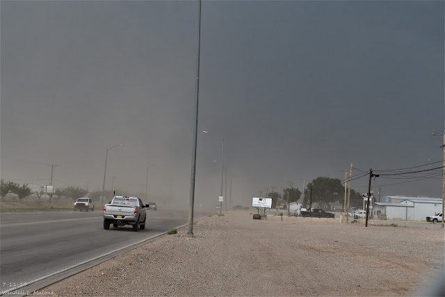
New Mexico's New Daily High Temp Records For July, 2019.
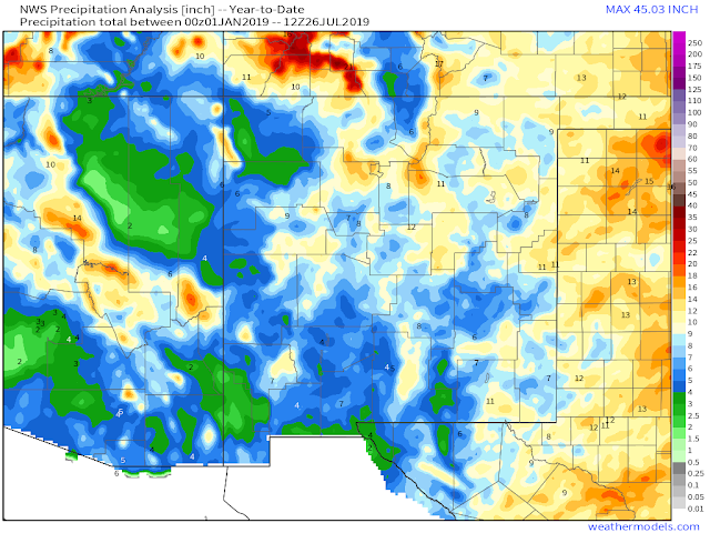

(January 1st - July 26th, 2019).


In spite of all of the media hype and craziness concerning Climate Change aka Global Warming, the data tells a different story. For much of the U.S. the average year-to-date temperature is running below normal (blue and green shaded areas). 

July so far has been a tad toasty for parts of New Mexico with numerous daily record high temperatures established. However when you step back and look at the big picture, you see that even with a hotter than normal July, the overall trend for the year so far  is our average temps are close to normal, and even below normal in a few areas.

North America Temperature Anomalies.
(July 1st - July 26th, 2019).


New Mexico's average temperature so far this July shows a mixed bag of variables. Its been warmer than normal across the eastern and southeastern plains, as well as the south central mountains, while much of the rest of the state is close to normal.

(July 1st - July 24th, 2019).


This July has been hot that's for sure for much of the local area. There have been some impressive new daily high temperature records broken so far this month too. 

The Roswell Industrial Air Center ASOS broke several daily records with two days of readings of 108ºF on the 19th, and 20th. The old records for these dates were last set in 2018 (107ºF) and 2009 (105ºF) respectively. On the 18th that station reached 107ºF breaking the old daily record of 105ºF set in 2018.

Jal reached 108ºF on the 11th breaking their previous daily record of 107ºF set in 1998.

Carlsbad reached 107ºF on the 21st breaking their previous daily record of 105ºF set in 1949.

Artesia reached 106ºF on the 21st breaking their previous daily record of 105ºF set in 2011.

The Truth Is Stranger Than Fiction - And Sometimes It Hurts!

Friday, July 26, 2019

How Hot - Wet - Dry So Far.


(January 1st - July 25th, 2019).


New Mexico Year-To-Date Rainfall Anomalies.
(January 1st - July 25th, 2019).


(June 1st - July 25th, 2019).


(January 1st - July 25th, 2019).


South Central NM & The Sacramento Mountains Highest Temperatures Year-To-Date.
(January 1st - July 25th, 2019).


Southern New Mexico Highest Temperatures Year-To-Date.
(January 1st - July 25th, 2019).


SE NM Year-To-Date Rainfall.
(January 1st - July 25th, 2019).


South Central NM & The Sacramento Mountains Year-To-Date Rainfall.
(January 1st - July 25th, 2019).


Southern New Mexico Year-To-Date Rainfall
(January 1st - July 25th, 2019).


Number of Days With High Temps Of 100º Or Higher So Far This Summer.
(June 1st - July 25th, 2019).

Roswell 24.
Artesia Climate 19.
2.1 NNW Downtwon Carlsbad 19.
Carlsbad Climate 21.
Carlsbad Airport 19.
Hobbs Climate 7.
Hobbs Airport 8.

Yes its been a typically hot summer but overall nothing unusual for the area. What is interesting is the wide gap in the rainfall totals to date. But that too isn't all that unusual either. So the summer drones on.

The Truth Is Stranger Than Fiction - And Sometimes It Hurts!

Monday, July 22, 2019

Slow Moving T-Storm Dumps On South Carlsbad 7-22-2019.


NWS Midland Dual Pol Radar Estimated Rainfall Totals.


(As Of 8 PM MDT).


(As Of 8 PM MDT).


(As Of 8 PM MDT).


Slow moving thunderstorms dumped on Carlsbad and and nearby areas this afternoon. Radar estimates put the total between 1.00" and 3.00" in and around the city. Widespread street flooding was noted in south Carlsbad. The first thunderstorm rolled into the city around 2:40 PM MDT. The second storm hit the city at 4:20 PM MDT. A Flash Flood Warning was issued by the Midland National Weather Service Office from 4:03 through 7:00 PM MDT for Eddy and Lea Counties including Carlsbad and nearby locations.

Reported rainfall totals in and around Carlsbad include the following:


Overnight I picked up .22" at our home in northwest Carlsbad and another .85" from this afternoons storm for a total of 1.07". This brings my July total to 2.02" and my year-to-date total to 4.62". Still about three inches below normal to date. 

The Carlsbad Airport ASOS was not reporting its rainfall total as of 8 PM MDT. 


The Truth Is Stranger Than Fiction - And Sometimes It Hurts!

Saturday, July 13, 2019

Continued Hot For The Next Week.


Today.


Sunday.


Monday.


Tuesday.


Wednesday.


Thursday.


Friday.


Hot dry conditions are forecast to continue for the local area into the end of next week. A dome of high pressure in the mid-upper levels of the atmosphere centered over the Central Rockies this morning will dominate our weather into the end of next week. This effectively acts as a lid on a pot on a stove trapping heat underneath it. Some of the models argue that a shift in the location of the center of the high by the end of next week may open up the door for a more southerly flow and influx of moisture into the area. Thus more seasonal like temps and increased chances for thunderstorms...maybe. 


Valid Today Through Tuesday, July 16th, 2019.

Current forecasts call for the best chances for any storms to occur over and near the northern mountains of the state.

Official High Temperatures Recorded So Far This Year.
(As Of Friday, July 12th, 2019).

Carlsbad Climate 108ºF July 11th.
Jal Climate 108ºF July 11th.
Wink, TX Airport 108ºF July 10th.

Pecos, TX Airport 107ºF June 20th, July 10th.

Roswell Airport 106ºF July 10th.
NW Carlsbad (Me - Unofficial Reading) 106ºF July 10th.

Artesia Climate 105ºF July 11th.
Brantley Lake Climate 105ºF July 11th.

Bitter Lakes Wildlife Refuge Climate 104ºF July 8th.
Carlsbad Airport 104ºF June 20th.

Hobbs Climate/Airport 102ºF July 10th.

Holloman AFB 100ºF June 26th, July 5th.
Hope Climate 100ºF July 10th.

Pine Springs Raws (Guadalupe Mtn's Natl Park) 95ºF July 4th.
Elk Climate 93ºF July 10th.

Sierra Blanca Regional Airport 88ºF July 10th.
Cloudcroft Climate 84ºF July 10th.
Bowl Raws (North Of Guadalupe Peak) 83ºF July 4th.
Sierra Blanca Snotel (Near Ski Apache) 74ºF July 5th.

Note: The Sierra Blanca Snotel automated weather station located near Ski Apache at 10,280' has had the "coolest high temp" so far this summer. 

Note: The Cloudcroft Cllimate Co-Op Station at 8,698' was two degrees short of tying their all time record high temp (1901 - 2019) on July 10th. Their all-time high temperature of 89ºF was recorded on July 4th, 1951.

Note: The Artesia, Carlsbad, Brantley Lake, and Jal Climate Co-Op Stations record their 24-hour high and low temperatures between 6-8 AM. So the readings they reported for July 11th actually occurred on July 10th. 

Yes its been pretty hot so far this summer but far from record shattering. 

Carlsbad's 108ºF on July 10th is the 68th time that the Climate Co-Op Station has reached a temperature that high. 

Jal's 108ºF on July 10th is the 51st time they have been that hot.

Roswell's high of 106ºF on July 10th was the 66th time they have been that hot.

Climate Information Is Courtesy Of:


The Truth Is Stranger Than Fiction - And Sometimes It Hurts!

Friday, July 12, 2019

Strong Thunderstorm Rolls Through Carlsbad Thursday, July 11th, 2019.


Looking North On US Hwy 62/180 Just North Of The Airport.

Looking South On US Hwy 62/180 Just South Of The Airport.

Curb to Curb Street Flooding On 6th Street.

Curb To Curb Street Flooding On Blodgett Street.

Curb To Curb Street Flooding On Blodgett Street.

Large Tree Limb Blown Down On Canyon Street In North-Central Carlsbad.


This Personal Weather Station (PWS) reported a thunderstorm wind gust of 60 mph at 2.59 PM MDT Thursday afternoon along with .86" of rainfall. 


This PWS reported 2.11" of rain from Thursday afternoons thunderstorm.

NWS Midland Dual Pol Doppler Radar Estimated Rainfall Totals.


(As Of 7 PM MDT Thursday).


(As Of 7 PM MDT Thursday).


A strong thunderstorm moved into Carlsbad from the northeast just before 3 PM Thursday afternoon. A Personal Weather Station (PWS) in east Carlsbad in the Ridgecrest Subdivision clocked a thunderstorm wind gust to 60 mph at 2:59 PM. Thus the reason for the large tree limb blown down on Canyon street.

Heavy rains fell across the northern and eastern one half of the city with our usual street flooding commencing. The heaviest rains according to radar were northeast of the city.

Here on the northwest side of the city I measured .62". This brings my July total up to .96" and my year-to-date total up to 3.56". The 118 year average for rainfall for Carlsbad from January through July is 6.51". So I've had about half of our long term average rainfall to date.

The Carlsbad Airport located 5 miles south-southwest of downtown only recorded .09". A peak gust of 45 mph was clocked at 3:08 PM. A Skywarn Spotter reported penny size hail in Artesia at 1:19 PM.

The Truth Is Stranger Than Fiction - And Sometimes It Hurts!

NWS Albuquerque Burn Scar Matrix Forecast

Current NWS Watches/Warnings In Effect

New Mexico

Eddy County

Chaves County Plains & Mtn's

Culberson County

Lea County

Lincoln County

Otero County

Current US Temps

Current US Wind Chill/Heat Index Temperatures

NWS Midland Forecast

NWS Albuquerque Forecast

NWS Albuquerque Forecast

NWS El Paso Forecast

NWS Lubbock Forecast

NWS Lubbock Forecast

Average Daily High/Low Temperatures & Rainfall

Average Daily High/Low Temperatures & Rainfall