My Current Weather

Thursday, September 25, 2014

Flash Flooding Update 9-25-2014.


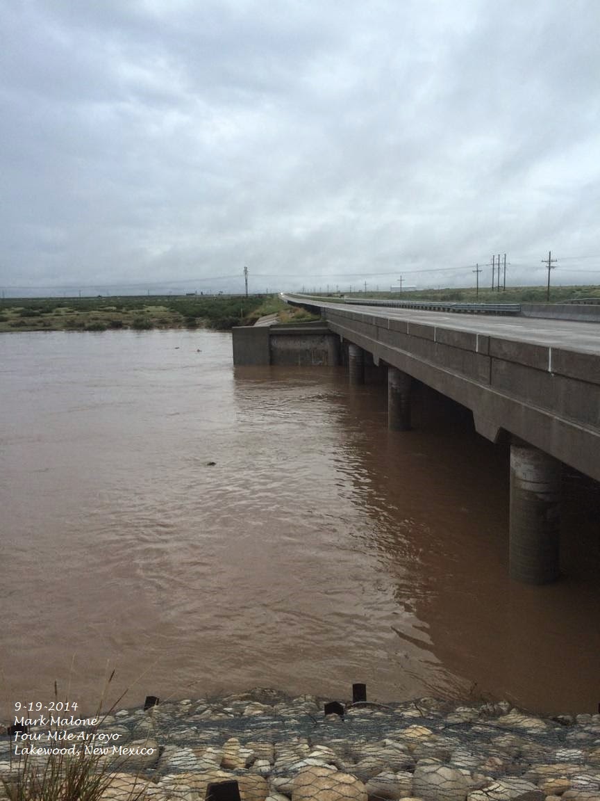
9-21-2014
Eagle Draw - Artesia, NM.

9-21-2014.
Eagle Draw - Artesia, NM.

9-21,22-2014.
Dark Canyon Arroyo.
Carlsbad, New Mexico.

14-Day Rainfall Totals.

NWS AHPS 14-Day Rainfall Totals.


CoCoRaHS 14-Day Rainfall Totals.
(Sept 10 -Sept 23, 2014).


Public 14-Day Rainfall Totals.
(Sept 10 -23, 2014).

2 Miles East Malaga 25.00"
Durante Rd 1 Mile East Malaga 22.25"
Derrick Rd/Old Cavern Hwy 21.50"
Between Kincaid Ranch Rd & Rockin R Red Rd 17.70"
Kennel Rd 16.70"
South 6th St Carlsbad 16.50"

Rainfall totals are courtesy of Woods Hougton and the Eddy County Extension Service - Agriculture. 

The Truth Is Stranger Than Fiction! 

 My Web Page Is Best Viewed With Google Chrome.

Tuesday, September 23, 2014

Rainfall Totals & Historic Flash Flooding On Dark Canyon - 9-23-2014.


9-22-2014.
Callaway Drive.
Carlsbad, New Mexico.

9-21-2014.
Eagle Draw - US Hwy 285 Bridge In Artesia, NM.

9-22-2014.
Fanning Road.
Normally Dry Rio Penasco River.
9 Miles SSE Of Artesia, New Mexico.

9-21-2014.
Normally Dry Dark Canyon Arroyo.
San Jose Blvd - Carlsbad, New Mexico.

9-22-2014.
Normally Dry Dark Canyon Arroyo. 
 San Jose Blvd, Carlsbad, New Mexico.

Unfortunately I wasn't able to capture any video of Dark Canyon Arroyo during at its highest flood stage, which occurred just before midnight Sunday, September 21,2014. I was at the Eddy County Emergency Operations Center assisting local official's with weather updates. 

Record/Historic Flooding On Dark Canyon.


Record/Historic flash flooding occurred in the Dark Canyon Arroyo that runs through the heart of Carlsbad, New Mexico Sunday night just before midnight. The flood gauge water depth in the arroyo peaked at 21.62 feet. This is the second highest depth ever measured in the arroyo. This depth is second only to the August 23, 1966 record of 22.00 feet. At the peak depth Sunday night the water was raging down the arroyo at an incredible 92, 700 cubic feet a second (cfs). I'm not sure but this may be the highest flow on record, if not the second highest. Its believed that an estimated 100,000 cubic feet a second occurred in Dark Canyon during the flash flooding in September 1941.

During the flash flood of April 4, 2004 the arroyo reached a depth of 21.62 feet. Last September 12th it reached a depth of 17.85 feet. During the flooding of June 24, 1986 it reached a depth of 12.53 feet. And on September 26, 1980 12.10 feet.

There was a great deal of concern that the flood waters were going to top the Canal Street bridge near La Tienda Grocery Store in Carlsbad Sunday night...and with good reason. The flood waters came to within a foot from the bottom of the bridge of doing this. 

14-Day & 30-Day Rainfall Total Graphic Maps.


Two week storm total rainfall amounts have exceed 20.00 inches in parts of Eddy County. Here at my home in northwest Carlsbad I measured 8.47" over the past two weeks. Bringing my September month to date total to 9.68", and my year to date total to 15.48".

The Truth Is Stranger Than Fiction! 

 My Web Page Is Best Viewed With Google Chrome.

Sunday, September 21, 2014

Flash Flood Update - Sunday 9-21-2014.


9-19-2014.
Lakewood, New Mexico.
Courtesy Of Mark Malone.
Flash Flooding On Normally Dry Four Mile Arroyo

(As Of 7:45 AM MDT).


10-Day Rainfall Totals.
(As Of 7 AM MDT Sun, Sept 20, 2014).

Loving 12 miles SE of Carlsbad 18.00"
 Otis 6 SE Carlsbad 15.50"
 South 6th St Carlsbad 11.50"
Pecos River Near Orla, TX 10.41"

Monument 1.2 W 9.63"
Bat Draw Raws 9.52"
 South Carlsbad Haston Rd 9.50"
 Southeast Carlsbad Sunnyview 8.40"
 Carlsbad Wagon Wheel Rd 7.00"
Pine Springs Pinery Raws 6.90"
Bowl Raws Near Guadalupe Pk 6.71"
Paduca Raws Near WIPP 6.67"
McKittrick Canyon 6.51"
SE Carlsbad N5MJ 6.45"
 17.1 NW Carlsbad 6.23"
Hobbs 2.4 ESE 6.18"
 South Carlsbad McKinley Rd 6.00"

Hobbs KM5BS 5.60"
 Carlsbad 2 N 5.54"
  Carlsbad 1.9 NW 5.51"
Lovington 0.9 NNW 5.44"
Queen 33.3 WSW Carlsbad 5.34"
 Carlsbad 2.1 NNW 5.09". 

Dog Canyon SW Of Queen 4.93"
Caprock Raws 4.90"
Buck Mtn Near Alto 4.52"
Queen Raws 4.37"
Artesia 3.5 NNE  4.10"
Mayhill CW9878 4.04"

Sunspot 0.07 N 3.98"
Sacramento Peak Observatory 3.78"
Roswell 0.3 SSW 3.58"
Weed K5TCS 3.46"
Hobbs KCOERY 3.14"
Tatum 1.7 SW 3.08"
Ruidoso 1.7 WNW 3.05"
Cloudcroft DW7382 3.04"

Dunken Raws 2.97"
Artesia ASC 2.91"
Smokey Bear Raws Ruidoso 2.41"
Roswell Airport 2.28"
Rainfall Reports Are Courtesy Of-

The General Public

The Truth Is Stranger Than Fiction! 

 My Web Page Is Best Viewed With Google Chrome.

Saturday, September 20, 2014

Flash Flooding Eddy Co NM- 9-19-2014.


9-18/19-2014.
Courtesy Of Wendell L. Malone
Carlsbad, New Mexico Flash Flooding.


9-18/19-2014.
Courtesy Of Diane J. Malone
Carlsbad, New Mexico Flash Flooding.

9-19-2014.
Flash Flooding On Four Mile Arroyo.
Video Courtesy Of Owen Lyles Of Lakewood, NM.
Water Depth Over The Road Here Was 20 Feet Deep!

9-19-2014.
Courtesy Of Richard Aves Of Carlsbad, NM.
Delaware River - US Hwy 285 South Of Malaga, NM.


NWS 4-KM 7-Day Precipitation Totals.


NWS 4-KM 14-Day Precipitation Totals.

Blog Update @ 10:40 AM MDT 9-20-2014.


• Eddy County remains under a flash flood watch with a 50% chance of rain. Whites City Road and Lakewood road remain closed with no access allowed due to current conditions. For your safety, DO NOT cross barricaded roads. Overnight, Carlsbad Fire and EMS responded to a scene where three people were stranded after driving around a barricade. Stay away from flooded areas. 

• The National Guard continues to provide assistance in getting supplies to, and extracting, the 48 person work crew that sheltered in place overnight south of Whites City Road. Air resources will be performing air reconnaissance of Southeastern Eddy County looking for any other stranded people and reporting any environmental concerns.

• The crew of 54 reported last night as stranded at a different location were able to self-rescue overnight. 

• The SKP Ranch/Lakewood area remains flooded. Residents needing Red Cross assistance can contact the Red Cross at 1-800-560-2302. 

• The area in Loco Hills where the sink hole appeared remains evacuated and secured.
• CID believes that the dam at Lake Avalon will continue to have water flowing over the spillway throughout today at reduced levels from those observed last night. Residents living downstream from Lake Avalon should take necessary precautions to protect their property due to the increased flow in the Pecos River.

• Eddy County EOC would ask all business interests located in the SE part of Eddy County to suspend operations as soon as possible until waters in the area have receded and it is once again safe to cross low water areas.


Heavy localized rain may continue throughout the night, use all precautions. Stay away from flooded areas. 

The Eddy County Sheriff’s Office with the assistance of Texas Rangers and New Mexico State Police located a male individual south of Carlsbad near the Delaware River. The male individual, later identified as Randy Boland of Odessa Texas was deceased upon law enforcement arrival. The cause of Mr. Boland’s death is being investigated by the Eddy County Sheriff’s Office.
There are several vehicles stranded throughout SE Eddy County. Crewa are working to locate and assist as possible. 

The National Guard and Eddy VFD ‘s have evacuated 40 workers from a frac job location. Additional crews of 48 and 54 respectively have been identified as stranded on a different location. This second crew is in an area that is currently inaccessible. Efforts are underway to airlift supplies to them. 

The SKP Ranch/Lakewood area remains flooded. Residents needing Red Cross assistance can contact the Red Cross at 1-800-560-2302. 

The area in Loco Hills where the sink hole appeared has been evacuated and secured.
CID believes that the dam at Lake Avalon will have water flowing over the spillway between 2000hrs and 2200hrs with flow reaching Carlsbad sometime after 2200hrs. Avalon is currently receiving 300cfs of flow. The water flow in Rocky Arroyo is receding at this time. Residents living downstream from Lake Avalon should take necessary precautions to protect their property due to the increased flow in the Pecos River.

Eddy County EOC would ask all business interests located in the SE part of Eddy County to suspend operations as soon as possible until waters in the area have receded and it is once again safe to cross low water areas.

The Truth Is Stranger Than Fiction!

 My Web Page Is Best Viewed With Google Chrome.

NWS Albuquerque Burn Scar Matrix Forecast

Current NWS Watches/Warnings In Effect

New Mexico

Eddy County

Chaves County Plains & Mtn's

Culberson County

Lea County

Lincoln County

Otero County

Current US Temps

Current US Wind Chill/Heat Index Temperatures

NWS Midland Forecast

NWS Albuquerque Forecast

NWS Albuquerque Forecast

NWS El Paso Forecast

NWS Lubbock Forecast

NWS Lubbock Forecast

Average Daily High/Low Temperatures & Rainfall

Average Daily High/Low Temperatures & Rainfall