My Current Weather

Friday, April 29, 2016

Windy & Dusty Today - Snow In Northern NM.
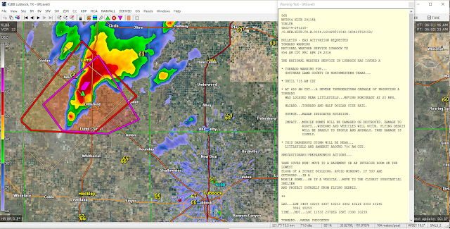


You don't see many Tornado Warnings this early in the morning in West Texas. Radar indicated a possible Tornado over Littlefield in southeastern Lamb County 30 miles northwest of Lubbock at 6:05 AM MDT/7:05 AM CDT this morning. A wall cloud was reported with the storm at 6:17 AM MDT/7:17 AM CDT.


Severe thunderstorms across West Texas this morning. High winds and more blowing dust across parts of New Mexico and West Texas this afternoon. Southwest to west winds are forecast to gust up to 65 mph in the Guadalupe Mtn's and 45-50 mph across the southeastern plains of New Mexico. Click on this link for the latest National Weather Service Watches and Warnings. 

After seeing high temps today and Saturday in the mid 70's to near 80 a strong cold front will enter the local area Saturday night and drop our daytime highs back down in the 50's and 60's on Sunday and Monday. We may see some scattered thunderstorm activity off and on Saturday night into Tuesday as well.

The Truth Is Stranger Than Fiction!

Thursday, April 28, 2016

And The Wind & Dust Are Back - Especially On Friday.


Strong Storm To Our West.


High Fire Danger & Windy Today Into Friday.


In true New Mexico tradition our spring is turning out to be a windy and dusty one across much of the state. Today will be breezy with southwesterly winds gusting up to around 30 mph this afternoon and continuing overnight. High temperatures across southeastern New Mexico and parts of West texas will be in the mid-upper 80's today. A Wind Advisory has been issued for southern New Mexico for today for southwesterly winds sustained at 30 mph with gusts near 50 mph. A Blowing Dust Advisory is also in effect for areas of blowing dust reducing the visibility down to less than one mile at times mainly in the El Paso and Lordsburg areas today.

As a strong mid-upper level storm to our west approaches from the west on Friday southwesterly winds will crank up even higher locally. A High Wind Watch is in effect for the Guadalupe Mtn's for southwesterly winds gusting up to around 60 mph on Friday. Highs on Friday will be in the mid 70's to near 80. 


Scattered thunderstorms are still forecast to fire up along and east of the dryline tonight east of the Pecos River. Some of these could become severe especially across West Texas. Another round of thunderstorms still looks possible Sunday night and into the first of next week. Some of these storms may also become severe. 


The Truth Is Stranger Than Fiction!

Wednesday, April 27, 2016

Less Wind Today Into The Weekend.


Click On The Link Above To See The Complete List Of Reports.

(Ending @ 6 PM MDT Tuesday, May 3rd).


Our next best hope for any rainfall here in southeastern New Mexico may come Sunday night as the next Pacific storm drops into northern Arizona. Disturbances rotating northeastward out of this storm could interact with the dryline to produce scattered thunderstorms across the eastern third of the state late this upcoming weekend into the first of next week.

The Truth Is Stranger Than Fiction!

Sunday, April 24, 2016

La Nina Looms - Bad News For New Mexico!


A Very Humbling Photo To Say The Least. Now My Facebook Profile Picture.

Blog Updated @ 7:50 PM MDT Sunday, April 24, 2016.

As El NiƱo Continues To Weaken - La Nina Looms.
(Bad News For New Mexico & The Desert Southwest). 

(December 31, 2015).

(April 21, 2016).  

Compare the sea surface temperature maps (above) from last December with the current map (today). Its fairly obvious how quickly and how much the Equator Pacific sea surface temperatures are dropping thus signaling the coming end of El NiƱo conditions with a return to La Nina conditions by this fall and winter.


Sea surface temperatures across and near the Equatorial Pacific Ocean continued to cool as El NiƱo continues to weaken. This trend is forecast by the models to continue. In fact a La Nina Watch has been issued by NOAA. Bad news for New Mexico because La Nina's produce the opposite weather that El NiƱo's do. Meaning drought conditions will likely worsen in time.

Hot dry springs and summers with an increased risk of fire danger especially after the wet last several years we've had. Lots of dry tall grasses and brush available to fuel wildfires. Not to mention that dust storms will be more common.


Current U.S. Drought Monitor Status.

U.S. Drought Outlook April - July, 2016.

There may be some temporary hope in May. Typically during an El NiƱo our weather in May and sometimes into June can be rather active. Meaning lots of thunderstorms, some of which are severe, and flash flooding. Its a coin toss as to what will happen this year. April across southeastern New Mexico has been relatively dry. More on this via the Albuquerque National Weather Service SkyWatcher Spring-2016 Newsletter

(2011 - 2015).


My Rainfall Totals Here In Carlsbad, New Mexico.

2011= 5.84"
  2012= 12.48"
  2013= 16.35"
  2014= 17.52"
  2015= 20.85"
                                   2016= 1.13" (Jan 1st - Apr 24th).

The Truth Is Stranger Than Fiction!

Sunday, April 17, 2016

Winter Still Isn't Done With New Mexico & Colorado.


A trained Skywarn Spotter reported a storm total of 50.6" of snowfall in Pinecliffe located in Jefferson County Colorado this morning. Check out meteorologists Reed Timmer's video on his twitter page of the 40" of snow on the ground near Golden, Colorado this morning. 

Snow Drone - Spring Snow Storm Flight in Denver

April 17, 2016.

24-Hour NM Rainfall Reports.

 • 6 NE Ponderosa - 1.14 in.
 • 4 NW Lama - 0.85 in.
 • 3 W El Prado - 0.70 in.
 • 11 ENE Jemez Springs - 0.64 in.
 • 13 NW Bandelier Natl Monument - 0.61 in.
 • 1 WNW Gascon - 0.58 in.
 • 11 ENE Jemez Springs - 0.58 in.
 • 2 SSE La Cueva - 0.55 in.
 • 5 NNE Sedan - 0.55 in.
 • 16 NNE Jemez Springs - 0.54 in.
 • 3 WNW Gallup - 0.53 in.
 • 2 SSE Taos - 0.51 in.
 • 17 NW Bandelier Natl Monument - 0.46 in.
 • 4 WSW Mills - 0.46 in.
 • Tres Piedras - 0.44 in.
 • 12 S Monero - 0.44 in.
 • 1 SE Talpa - 0.40 in.
 • 11 W El Vado - 0.40 in.
 • 12 SSW El Vado - 0.38 in.
 • 18 SW Dulce - 0.36 in.
 • 4 NNW Jemez Springs - 0.36 in.
 • 7 SSW Coyote - 0.34 in.
 • 3 ENE Truchas - 0.33 in.
 • 14 SSE Pine Hill - 0.33 in.
 • 7 NW Zuni Pueblo - 0.33 in.
 • 3 SSE Bloomfield - 0.31 in.
 • 12 N Navajo Dam - 0.30 in.
 • 2 W El Morro - 0.28 in.
 • 6 SSW San Mateo - 0.28 in.
 • 4 NE Alcalde - 0.27 in.
 • 2 SSW Milan - 0.27 in.
 • Narbona Pass - 0.25 in.
 • 19 SW Acoma Pueblo - 0.23 in.
 • 2 ENE Clayton - 0.22 in.
 • 1 ENE Santa Cruz - 0.21 in.
 • Raton Crews Airport - 0.20 in.
 • 2 SSW Milan - 0.19 in.
 • 1 W Nambe - 0.18 in.
 • 4 NW Santa Fe - 0.18 in.
 • 9 SSW Bluewater Lake - 0.17 in.
 • 9 SW Cuba - 0.17 in.
 • 1 NNE Aztec - 0.16 in.
 • 6 NNW Guadalupita - 0.14 in.
 • 8 NNW Omega - 0.13 in.
 • 7 E Albuquerque - 0.13 in.
 • 3 WSW Rio Rancho - 0.12 in.
 • 3 WNW Madrid - 0.11 in.
 • 6 WNW Espanola - 0.11 in.
 • 2 WSW Rio Rancho - 0.10 in.
 • 8 NW Albuquerque - 0.10 in.
 • 4 ESE Albuquerque - 0.10 in.
 • 6 NE Rio Rancho - 0.10 in.

24-Hour NM Snowfall Reports

• 2 NNE Questa - 8.7 in.
 • 8 NE Arroyo Seco - 8.0 in.
 • 5 ESE Red River - 6.0 in.
 • 4 NNW Tres Ritos - 6.0 in.
 • 11 ENE Amalia - 5.0 in.
 • 2 NNE Questa - 4.7 in.
 • Cowles - 3.0 in.
 • 2 SSW Los Cordovas - 2.1 in.
 • 9 E Cuba - 2.0 in.
 • 8 SW Rociada - 2.0 in.
 • Eagle Nest - 2.0 in.
 • 11 ENE Red River - 2.0 in.
 • 2 WNW Manuelitas - 1.8 in.
 • 1 SSE Gallup - 1.5 in.
 • 1 ESE Truchas - 1.2 in.
 • 2 SSE Taos - 1.0 in.
 • Capulin - 1.0 in.
 • 2 W Datil - 0.1 in.

The Truth Is Stranger Than Fiction!

NWS Albuquerque Burn Scar Matrix Forecast

Current NWS Watches/Warnings In Effect

New Mexico

Eddy County

Chaves County Plains & Mtn's

Culberson County

Lea County

Lincoln County

Otero County

Current US Temps

Current US Wind Chill/Heat Index Temperatures

NWS Midland Forecast

NWS Albuquerque Forecast

NWS Albuquerque Forecast

NWS El Paso Forecast

NWS Lubbock Forecast

NWS Lubbock Forecast

Average Daily High/Low Temperatures & Rainfall

Average Daily High/Low Temperatures & Rainfall