


Snow In New Mexico & Colorado - Severe T-Storms In West Texas Today.

(At 9:00 AM MDT This Morning).

Taking a look at the latest image above its pretty easy to see where the center of our latest strong mid-upper level storm is located this morning, just west of Albuquerque. The red color shaded areas to the bottom or south of the low depicts very dry air.
Snowing In Colorado.

Snow fell over parts of northern New Mexico yesterday afternoon and overnight. Heavy snow was falling over central and eastern Colorado this morning. Snow on the composite image above is indicated by the blue shades, a wintry mix by the pink shades, rain by the green and yellow shades, thunderstorms by the reds.
Cold Mid-April Morning In The West.

Valid @ 6 PM MDT.


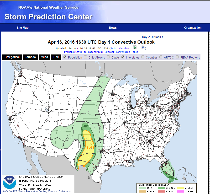
Another round of severe thunderstorms is forecast this afternoon and evening from Southwestern Kansas southward into Far West Texas. Once again the dryline is forecast to light up over West Texas with a few supercell thunderstorms capable of producing large hail and a few isolated tornadoes. A southward moving cold front will also become the focus for severe thunderstorms over the Western Oklahoma Panhandle and Texas Panhandle.


Good news and bad news for southeastern New Mexico today. The good news is that the dryline has been shoved east into West Texas thus killing our chances for severe thunderstorms this afternoon. The bad news is there goes our best shot at rainfall too. A High Wind Warning remains in effect for the Guadalupe Mountains of Culberson County (Guadalupe Pass Area) for southwesterly winds sustained at 25-35 mph with guts near 60 mph.

Hail Reports.
• 3 E Seneca - 1.25 in.
• Clayton - 0.75 in.
• 15 NNE Clayton - 0.70 in.
• 3 SE Farmington - 0.15 in.
• Clayton - 0.75 in.
• 15 NNE Clayton - 0.70 in.
• 3 SE Farmington - 0.15 in.
Snowfall Reports.
• 5 SSE Llano Largo - 6.0 in.
• 6 WNW Tererro - 5.0 in.
• 8 NE Arroyo Seco - 5.0 in.
• 11 NNW Canon Plaza - 5.0 in.
• 11 ENE Amalia - 4.0 in.
• 8 SW Rociada - 3.0 in.
• 8 SSW San Miguel - 3.0 in.
• 5 E El Morro - 3.0 in.
• 11 ENE Red River - 3.0 in.
• 9 ENE Shady Brook - 2.0 in.
• 5 ESE Red River - 2.0 in.
• 6 WNW Tererro - 5.0 in.
• 8 NE Arroyo Seco - 5.0 in.
• 11 NNW Canon Plaza - 5.0 in.
• 11 ENE Amalia - 4.0 in.
• 8 SW Rociada - 3.0 in.
• 8 SSW San Miguel - 3.0 in.
• 5 E El Morro - 3.0 in.
• 11 ENE Red River - 3.0 in.
• 9 ENE Shady Brook - 2.0 in.
• 5 ESE Red River - 2.0 in.
Rainfall Reports.
• 2 ENE Clayton - 0.41 in.
• 2 W Farmington - 0.22 in.
• 1 WSW Farmington - 0.21 in.
• 2 W Santa Cruz - 0.21 in.
• 1 SW Fort Sumner - 0.20 in.
• 1 WNW Clovis - 0.18 in.
• 12 S Monero - 0.18 in.
• 1 ENE Rio Rancho - 0.11 in.
• 9 NE Albuquerque - 0.11 in.
• 2 W Farmington - 0.22 in.
• 1 WSW Farmington - 0.21 in.
• 2 W Santa Cruz - 0.21 in.
• 1 SW Fort Sumner - 0.20 in.
• 1 WNW Clovis - 0.18 in.
• 12 S Monero - 0.18 in.
• 1 ENE Rio Rancho - 0.11 in.
• 9 NE Albuquerque - 0.11 in.
The Truth Is Stranger Than Fiction!


Comments
Post a Comment
Your comments, questions, and feedback on this post/web page are welcome.