My Current Weather

Friday, March 30, 2018

NM Record Highs For March 2018 - Latest Rainfall/Snowfall/Drought Conditions.
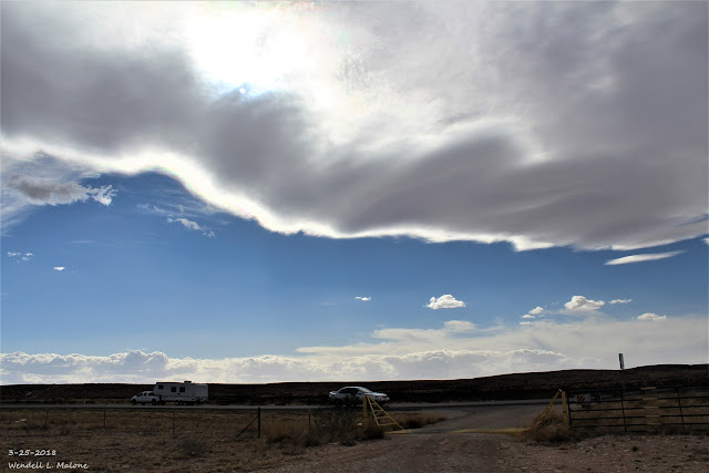
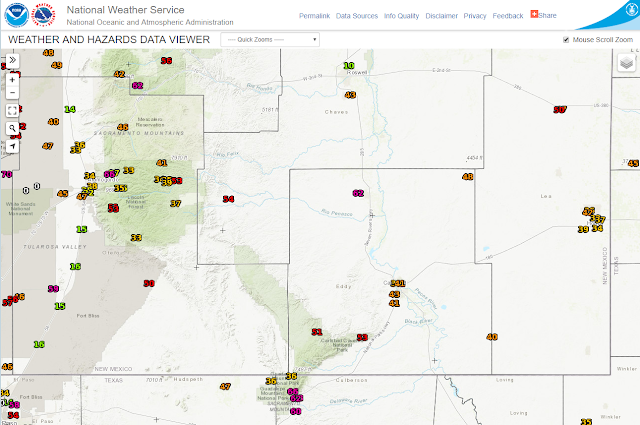


High Temperature Map For March 23, 2018.


High temperature Map For March 24, 2018.


Here at our home in northwest Carlsbad I recorded the following high temperatures:

Thursday, March 22nd 92ºF
Friday, March 23rd 91ºF
Saturday, March 24 90ºF

(January 1st - March 29th, 2018). 


U.S. 90-Day Rainfall Anomalies.
(Dec 29th, 2017 - March 29th, 2018). 


New Mexico Year-To-Date Rainfall.
(January 1st - March 29th, 2018). 


New Mexico 90-Day Rainfall Anomalies.
(Dec 29th, 2017 - March 29th, 2018). 


(July 1st, 2017 - March 29th, 2018).


Texas Seasonal Snowfall Totals.
(July 1st, 2017 - March 29th, 2018).


New Mexico Seasonal Snowfall Totals.
(July 1st, 2017 - March 29th, 2018).


Roswell, New Mexico.


Carlsbad, New Mexico.


Little hope for drought relief is offered by the latest forecast models over the next week to ten days locally...and most of the area for that matter. Above normal temperatures, continued very dry, and periods of breezy to windy weather are expected.

(March 30th).


The Truth Is Stranger Than Fiction!

Wednesday, March 28, 2018

Rainfall & Snowfall Reports As Of 5 AM MDT Wed March 28, 2018.


Radar Estimated Rainfall Totals.
(As Of 5 AM MDT Wednesday Morning).


(As Of 5 AM MDT Wednesday Morning).


legend

(AS Of 5 AM MDT Wednesday Morning).


Only light rainfall totals fell across most of the Southeastern Plains over the past couple of days. I  managed to pick up .02" here at our home in NW Carlsbad. Updated totals will added this evening.

(As Of 5 AM MDT Wednesday).

Snowfall-

• 5 NW CHAMA - 6.0 in.
 • 12 WSW SAN RAFAEL - 5.0 in.
 • 11 NNW CANON PLAZA - 4.0 in.
 •  null DULCE - 4.0 in.
 • 2 WSW EL MORRO - 3.9 in.
 • 1 N EL MORRO - 3.9 in.
 • 9 WNW TORREON - 3.5 in.
 • 7 ESE CUBA - 3.5 in.
 •  null CHAMA - 3.5 in.
 • 1 N DATIL - 3.0 in.
 • 7 E CANJILON - 3.0 in.
 • 8 SW ROCIADA - 3.0 in.
 • 9 E CUBA - 3.0 in.
 • 8 SSW SAN MIGUEL - 3.0 in.
 •  null PINE HILL - 3.0 in.
 •  null BLUEWATER LAKE - 2.5 in.
 • 2 W DATIL - 2.1 in.
 •  null PIETOWN - 1.5 in.
 •  null DULCE - 1.5 in.
 • 8 NNW OMEGA - 0.8 in.
 •  null SANDIA PARK - 0.8 in.
 • 9 WSW CUBA - 0.5 in.
 • 6 SW DATIL - 0.5 in.
 •  null ARAGON - 0.5 in.
 • 3 W THOREAU - 0.5 in.
 • 1 E ARROYO SECO - 0.2 in.
 • 1 SE SAN GERONIMO - 0.1 in.
 • 5 WNW COOLIDGE - T in.

The Truth Is Stranger Than Fiction!

Monday, March 26, 2018

Rain Over The Guadalupe's & Virga/Blowing Dust In Carlsbad. 3-26-2018.


Rain Obscuring The Guadalupe Mountains.


Blowing Dust East Of Carlsbad.


Rain showers began obscuring the Guadalupe Mountains late this afternoon as streaks of virga (rain aloft evaporating before reaching the ground) produced areas of blowing dust in the Carlsbad area.

The Truth Is Stranger Than Fiction!

Sunday, March 25, 2018

Lenticular Clouds 3-25-2018.


Lenticular clouds over the Guadalupe Mountains southwest of Carlsbad, New Mexico.

The Truth Is Stranger Than Fiction!

Monday, March 19, 2018

Peak Wind Gusts On Sunday, March 18, 2018.


(Sunday, March 18, 2018).


(Sunday, March 18, 2018).

• 1 N CANNON AFB - 73 mph
 • 1 SSE CLINES CORNERS - 70 mph

 •  null FRIJOLES - 64 mph
 • 7 ENE TUCUMCARI - 63 mph
 • 18 NNE ENCINOSO - 62 mph
 • 2 SW ENDEE - 62 mph
 • 2 SSW FORT STANTON - 62 mph
 • 2 ESE SANTA ROSA - 61 mph
 • 5 S ALBUQUERQUE - 60 mph

 • 2 NE DUNKEN - 59 mph
 • 21 SE BOSQUE DEL APACHE REFUGE - 59 mph
 •  null STANLEY - 59 mph
 • 5 NW NOGAL - 58 mph
 • 13 SE TOLAR - 57 mph
 • 10 SW BINGHAM - 56 mph
 • 2 SW DORA - 56 mph
 • 3 NNW TEXICO - 55 mph
 • 3 WSW BELEN - 54 mph
 • 1 WNW LAS NUTRIAS - 54 mph
 • 9 ESE MESITA - 54 mph
 • 13 SE TOLAR - 53 mph
 • 8 SSW RED RIVER - 53 mph
 • 7 W OSCURO - 52 mph
 • 10 WNW ALBUQUERQUE - 52 mph
 • 4 SSE ROSWELL - 52 mph
 • 3 NNE LA CIENEGA - 52 mph
 • 1 NW SUMNER LAKE - 52 mph
 • 6 NE LAS VEGAS - 52 mph
 • 10 S BINGHAM - 52 mph
 • 1 NNW RUIDOSO - 51 mph
 • 3 NW SANDIA PUEBLO - 51 mph
 • 3 SW FARMINGTON - 50 mph

 • 4 WSW MILLS - 49 mph
 • 2 ENE CLAYTON - 49 mph
 • 3 NW BANDELIER NATL MONUMENT - 48 mph
 • 5 WSW OSCURO - 48 mph
 • 3 WNW GALLUP - 47 mph
 • 28 SE BOSQUE DEL APACHE REFUGE - 47 mph
 • 2 W FARMINGTON - 45 mph
 • 1 WNW RESERVE - 44 mph
 • 16 SSE EL MORRO - 44 mph
 • 5 E LOWER COLONIAS - 43 mph
 • 14 SSE PINE HILL - 42 mph

The Truth Is Stranger Than Fiction!

Friday, March 16, 2018

Peak Wind Gusts Reported Thursday, March 15, 2018.


(Thursday, March 15, 2018).


(Thursday, March 15, 2018).

• 1 NNW RUIDOSO - 62 mph
 • 8 SSW RED RIVER - 61 mph
 • 18 NNE ENCINOSO - 60 mph

 • 18 NNE ENCINOSO - 59 mph
 • 3 E BERNALILLO - 58 mph
 • 6 NE LAS VEGAS - 56 mph
 • 5 S ALBUQUERQUE - 56 mph
 • 5 NW NOGAL - 56 mph
 • 2 SSW FORT STANTON - 56 mph
 •  null STANLEY - 55 mph
 • 3 ESE MORIARTY - 55 mph
 • 28 SE BOSQUE DEL APACHE REFUGE - 55 mph
 • 2 NE DUNKEN - 54 mph
 • 1 SE TALPA - 54 mph
 • 9 ESE MESITA - 54 mph
 • 10 S BINGHAM - 54 mph
 • 2 SSW MILAN - 52 mph
 • 7 ENE TUCUMCARI - 52 mph
 • 2 ENE CLAYTON - 52 mph
 • 11 SE BOSQUE DEL APACHE REFUGE - 51 mph
 • 3 SE SANTA ANA PUEBLO - 51 mph
 • 10 SW BINGHAM - 51 mph
 • 10 WNW ALBUQUERQUE - 51 mph
 • 1 SSE CLINES CORNERS - 51 mph
 • 5 NNE SEDAN - 50 mph
 • 14 E BOSQUE DEL APACHE REFUGE - 50 mph
 • 22 SE BOSQUE DEL APACHE REFUGE - 50 mph
 • 21 SE BOSQUE DEL APACHE REFUGE - 50 mph

 • 3 WNW GALLUP - 49 mph
 • 3 WSW BELEN - 49 mph
 • 6 NW FRUITLAND - 49 mph
 • 5 WSW OSCURO - 49 mph
 •  null RATON CREWS AIRPORT - 49 mph
 • 17 WNW OSCURO - 48 mph
 • 7 W OSCURO - 48 mph
 • 15 NW CARRIZOZO - 47 mph
 • 1 NW SUMNER LAKE - 47 mph
 • 2 S SOCORRO - 47 mph
 • 18 WSW OSCURO - 46 mph
 • 14 NNE BITTER LAKE WILDLIFE REF - 46 mph
 • 2 N ALBUQUERQUE - 46 mph
 • 4 WSW MILLS - 46 mph
 • 2 SE CLOVIS - 45 mph
 • 3 NNE LA CIENEGA - 45 mph
 • 9 ESE TOHAJIILEE - 45 mph
 • 3 SW ARROYO SECO - 45 mph
 • 1 N CANNON AFB - 44 mph

The Truth Is Stranger Than Fiction!

NWS Albuquerque Burn Scar Matrix Forecast

Current NWS Watches/Warnings In Effect

New Mexico

Eddy County

Chaves County Plains & Mtn's

Culberson County

Lea County

Lincoln County

Otero County

Current US Temps

Current US Wind Chill/Heat Index Temperatures

NWS Midland Forecast

NWS Albuquerque Forecast

NWS Albuquerque Forecast

NWS El Paso Forecast

NWS Lubbock Forecast

NWS Lubbock Forecast

Average Daily High/Low Temperatures & Rainfall

Average Daily High/Low Temperatures & Rainfall