My Current Weather

Wednesday, November 30, 2016

A Wintry MIx This Weekend?


Valid At 5 AM MST Saturday, Dec 3, 2016.


There is a little better agreement among the computer forecast models concerning the track and speed of the next winter-like storm to impact the region this weekend. Although the details concerning how much snow falls, where, and when is still questionable. Last nights Canadian model drops this next storm into northwestern Mexico by Friday night into Saturday morning and forecasts a cutoff low to develop.

A mix of rain and snow and perhaps some sleet in some locals this weekend appears in the making. A cold front will drop southward into the area on Friday thus enhancing the low level upslope flow from the east...which will aide in the development of precipitation.

Again the exact track and location of this storm will determine how much snow falls and where. For now the Sacramento, Capitan, and Guadalupe mountains appear to be in the running for some decent totals. A cold rain perhaps will develop across the lower elevations on Friday and may change over to a wintry mix of rain, sleet, and or snow Friday night with this pattern repeating itself Saturday and Sunday. Our highs on Saturday may only be in the 30's and 40's.

As Of 5 AM MST This Morning.


The Truth Is Stranger Than Fiction!

Saturday, November 26, 2016

Windy Sunday - Mountain Snows Tonight Into Monday.

300 MB (30,000' MSL) Forecast.

Valid At 5 PM MST Sunday.

Winds aloft will be howling over New Mexico on Sunday thanks in part to the jet stream bisecting the state. The GFS forecast model is calling for the winds at the 30,000' level to be around 156 knots or 179 mph by sunset Sunday right over the top of southeastern and eastern New Mexico.

Thursday, November 24, 2016

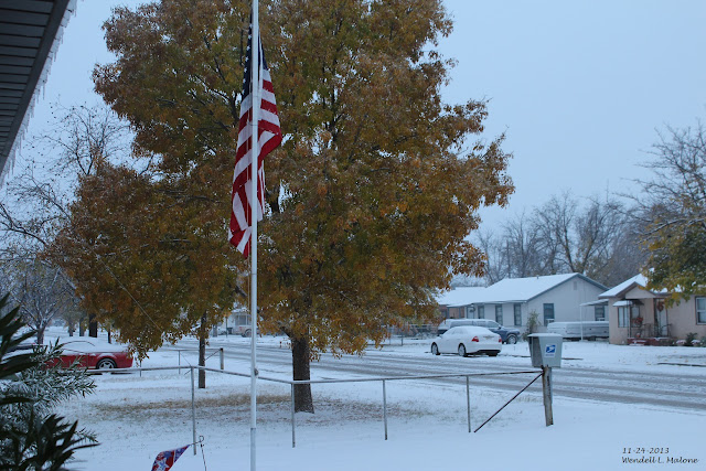
Winter Returns To Desert Southwest.


Carlsbad, New Mexico - November 24, 2013.

I recorded 3.3" of snowfall on the 23rd and 24th and a total of .91" of precipitation from that storm here at our home in Carlsbad. On the morning of the 24th snow had accumulated to a depth of 3". My high temp that day way 33ºF after a low of 27ºF. Artesia had 2" of snow out of the storm and Roswell recorded .3" with 3" on the ground on the morning of the 24th. 

Thursday, November 17, 2016

One Windy Day In The Land Of Enchantment.


Blog Updated @ 6:15 AM MST Friday, Nov 18, 2016.

Mayhill, New Mexico Baptist Church 11-5-2016.

Potent Storm Slides North Of New Mexico.

Wednesday, November 16, 2016

High Winds Thursday - First Freeze Friday & Saturday.


Very Dense Fog With Areas Of Light Rain And Drizzle From Artesia To Cloudcroft (Along US Hwy 82) On Nov 5th. Visibility Down To Less Than 100 Yards At Times.

Like October - November Warmer Than Normal.


So far the first half of November like October has been warmer than normal for New Mexico. Here in Southeastern New Mexico our temperatures are averaging some 5 to 10 degrees above the 30 year climatic normals. And we have yet to experience our first freeze of the season. This all will change by Friday and Saturday. 

Not Everyone Is Warmer Than Normal.


Don't Be Fooled By The Above Normal Temps.


Notice how cold it has been (below normal to much below normal) across the Northern Asian Continent. Some 20 to 50 degrees below normal in parts of Siberia. This slug of cold air will in time begin to spread eastward out of Siberia and eventually southward from the Arctic and Alaska and into the Continental U.S. A pattern shift is underway across North America which in time will favor a turn to colder and snowier weather across the U.S. in the coming weeks...especially December into January. At least that is what the long range forecasts indicators are pointing to. 

And don't be fooled by the warmer than normal temperature anomalies across the Arctic, Canada, and Siberia. Although these areas are warmer than normal they are already dropping down into the subzero range with some readings as cold as -20ºF to -30ºF. 


My low temperature here at our home in Carlsbad yesterday morning was a cool 39ºF. With a dry airmass in place and sunny skies my afternoon high shot up to 81ºF. That's a 42-degree temperature spread.

First Fall High Wind Event Thursday.

Valid @ 11 AM MST Thursday.

Valid @ 11 AM MST Thursday.

Valid @ 11 AM MST Thursday.


A potent upper level storm is set to dive southeastward out of the Pacific Northwest and into Northern New Mexico and Southern Colorado on Thursday. As a 125 knot or 144 mph jet stream wind speed max approaches the state Thursday afternoon the surface pressure gradient in response to this will tighten up. This at the time of peak heating will all combine to produce a very windy day across much of New Mexico and nearby areas Thursday. The strongest winds are forecast to occur over and near the Mountains, and across the Northeastern and Eastern plains. 

A High Wind Watch has been issued for these areas of the Albuquerque National Weather Service Forecast Area. Southwesterly winds are forecast to increase to sustained speeds of 30 to 45 mph with gusts around 60 to 70 mph. This includes the Ruidoso area.

A High Wind Watch has also been issued for the Guadalupe Mountains of Southeastern New Mexico and West Texas. Westerly winds sustained at around 35 to 45 mph are forecast to gust up to around 60 mph on Thursday.

Areas of blowing dust may suddenly drop the visibility across the lower elevations of the state while areas of blowing snow may do the same across parts of the Northern Mountains. 

Southwesterly winds sustained at around 20 to 30 mph with higher gusts are forecast for the Southeastern Plains on Thursday. Our highs today will once again top the 80-degree mark and the 70's are forecast for Thursday.

A cold front will sweep across the area Thursday night into Friday morning. Our highs on Friday are forecast to be in the 50's. Most of us will finally experience our first freeze of the season either Friday morning or Saturday morning.

The Truth Is Stranger Than Fiction!

Monday, November 14, 2016

Super Moon Setting Over The Guadalupe Mtn's 11-14-2016.


The Truth Is Stranger Than Fiction!

Season's First High Wind Event Thursday.


Valid @ 5 PM MST Thursday, Nov 17, 2016.


Valid @ 5 PM MST Thursday, Nov 17, 2016.


Valid @ 5 PM MST Thursday, Nov 17, 2016. 


Valid @ 5 AM MST Saturday, Nov 19, 2016.


A potent upper level storm depicted above at the 500 millibar or 18,000' Mean Sea Level (MSL) is still forecast by the models to dig southeastward into southern Colorado and northern New Mexico by Thursday afternoon, The latest run of the GFS model is dropping the storm a little further to the south so a little more snowfall is forecast for the northern New Mexico mountains...although at this time widespread heavy snowfall is not anticipated. 

Our first fall wind storm is still on track for Thursday as the surface pressure gradient tightens up as the stronger winds aloft mix down to the surface during peak afternoon heating. A High Wind Event looks possible for the mountains, and the eastern and northeastern plains. These areas may experience southwesterly wind gusts in excess of 60 mph.

 It will also be very windy in southeastern New Mexico with sustained winds in the 20-40 mph range with higher gusts. Localized areas of blowing dust may also develop across the state on Thursday. 

Our afternoon high temperatures are forecast to remain some 5-15 degrees above normal this week. With most of southeastern New Mexico and West Texas seeing the 70's. Thursday's afternoon highs may be above 80 degrees in a few local areas. A few record daily high temp records may be tied or broken this week.

A Pacific Cold Front will sweep eastward across the area Thursday night. With a cooler airmass in place and calm winds, and clear skies, most of southeastern New Mexico and nearby areas will see our first frost/freeze of the season Friday or Saturday morning.

The Truth Is Stranger Than Fiction!

Sunday, November 13, 2016

Finally A Storm To Watch - First Freeze Late Next Week?


Regional Temperatures @ 6 AM MST This Morning.


Cottonwood dipped down to 34ºF this morning for their coldest low of the season so far. My low temp here at our home in Carlsbad was 38ºF, also the coldest reading of the season.

Our First Fall Howler Late Next Week.

GFS 500 MB (18,000' MSL) Forecast.
Valid @ 5 PM MST Thursday, Nov 17, 2016.

A strong upper level storm is forecast to dive southeastward and into northern Colorado and southern Wyoming by sunset next Thursday. This storm will be a little too far north to bring any meaningful snowfall to New Mexico mountains. Unless of course it dips a little further to the south than is currently forecast. Some of our northernmost ski resorts may see some accumulations. Finally the death ridge of high pressure that has had us locked up and preventing the storm track from getting this far south has been broken...for now anyway.

Windy Thursday.

Pivotal Weather 700 MB (10,000') MSL Wind Forecast.
Valid @ 5 PM MST Thursday, Nov 17, 2016.

GFS 850 MB (5,000' MSL) Wind & MSLP Forecast.
Valid @ 11 AM MST Thursday, Nov 17, 2016.

Valid @ 11 AM MST Thursday, Nov 17, 2016. 

Valid @ 5 AM MST Saturday, Nov 19, 2016.


As the jet stream dives southeastward into the Four Corners Region Thursday winds aloft will strengthen. At the surface lee side troughing will develop along and east of the central mountains of New Mexico. Thus as the surface pressure falls in response to the approaching jet and storm to our northwest, the winds at the surface will also crank up. Southwesterly winds of 20-30 mph with higher gusts will develop across the eastern and southeastern plains, and nearby areas of West Texas by midday Thursday. The mountains may see these winds gust up to or over 60 mph. 

Valid @ 11 AM MST Thursday, Nov 17, 2016. 

Valid @ 5 PM MST Thursday, Nov 17, 2016.


An uneventful week weatherwise lies ahead for SE NM with our daily afternoon highs mostly in the 70's and lows in the 40's.

With hot dry downsloping southwesterly kicking in Thursday our afternoon high temps will likely climb up into the 75ºF to 80ºF range across the local area. These temps will be some 10 to 15 degrees above normal. 

Note: It appears that after a cold front moves through the region and a colder airmass settles in over the area Friday and Saturday most of southeastern New Mexico will experience our first freeze of the season by Saturday morning. 

Normal High & Low Temps For Nov 13th:

Taos 55/22
Red River 46/18
Santa Fe 54/29
Albuquerque 57/35

Gallup 56/20
Farmington 53/30

Clovis 62/31
Roswell 65/35
Artesia 68/32
Carlsbad 68/37
Hobbs 67/39

Picacho 65/32
Ruidoso 59/25
Elk 62/27
Cloudcroft 51/25

Alamogordo 67/38
Las Cruces 66/36
Silver City 59/31
El Paso 67/41
Midland/Odessa 68/40


The Truth Is Stranger Than Fiction!

NWS Albuquerque Burn Scar Matrix Forecast

Current NWS Watches/Warnings In Effect

New Mexico

Eddy County

Chaves County Plains & Mtn's

Culberson County

Lea County

Lincoln County

Otero County

Current US Temps

Current US Wind Chill/Heat Index Temperatures

NWS Midland Forecast

NWS Albuquerque Forecast

NWS Albuquerque Forecast

NWS El Paso Forecast

NWS Lubbock Forecast

NWS Lubbock Forecast

NWS Lubbock Forecast

Average Daily High/Low Temperatures & Rainfall

Average Daily High/Low Temperatures & Rainfall