My Current Weather

Wednesday, April 27, 2022

Golf Ball Size Hail In NW El Paso Last Night - Severe T-Storms Possible Today!
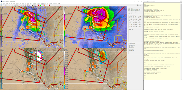
Tuesday, April 26, 2022, At 10:47 PM MDT.

(Tuesday, April 26, 2022).


(As Of 8:30 AM MDT Wednesday).


Severe Thunderstorms In Northwest El Paso Last Night.

A cluster of thunderstorms moved out of northern Mexico, southwest of El Paso, and northeastward into northwestern El Paso around 10:30 PM MDT last night. A severe thunderstorm warning was issued by the Santa Teresa/El Paso National Weather Service Office for southcentral Dona Ana and northwestern El Paso Counties at 10:38 PM MDT last night.

Spotters reported hail ranging in size from quarters (1" diameter) to golf balls (13/4" diameter) in the northwestern parts of the city. Rainfall totals ranged from around .20" to .50" of an inch.

Severe T-Storms Possible Today!


A few dryline thunderstorms are forecast for the area this afternoon and evening. A few of these may develop into slow-moving supercells and produce marginally severe hail to severe hail and damaging thunderstorm wind gusts in excess of 58 mph. Frequent deadly cloud-to-ground lightning will accompany any thunderstorms that form. Locally moderate to heavy rainfall is also possible with the strongest of these thunderstorms. Widespread rainfall is not expected.

The Truth Is Stranger Than Fiction!

Saturday, April 23, 2022

Current Drought Status - Outlooks - Friday's Peak Wind Gusts.

April 14, 2022.
Near Hondo, New Mexico.

(Oct 26, 2021 - April 23, 2022).


Looking at the 180-day (Oct 26, 2021 - April 23, 2022) precipitation totals and deficits for New Mexico and the region is somewhat depressing. Clearly, we had a very dry late fall and winter and this continues this spring. The Sacramento Mountains have generally received 1"-3" of precipitation during this time frame for the wettest locations locally. But that still puts them some 2"-3" below normal for the time frame. Cloudcroft has recorded 49.6" of snowfall for the season to date which ranks as the 38th driest (for snowfall) in the past 119 years. Ruidoso's snowfall records for the season are incomplete at this time.


New Mexico.


Texas.


Long Ranger Temperature & Precipitation Outlook.
(May - June - July).


Not Much Hope For Drought Relief.

Most of New Mexico and West Texas remains in the severe to exceptional drought category. Sadly there is not much if any real hope at this time in the long-range forecasts for meaningful relief. Long-range forecasts call for the drought to persist through July. Temperatures are forecast to be above normal with precipitation below normal from now through July.


Thankfully we dogged a bullet as far as fires are concerned here in Southeastern New Mexico including the Sacramento, Capitan, and the Guadalupe Mountains. We did have the very small James Fire east of Cloudcroft near the 16-Springs Canyon area but it was quickly contained and extinguished. Three other fires were reported yesterday afternoon as well. One near Caprock, one near Hagerman, and another northeast of Carlsbad. Those we quickly knocked down as well. Our hats are off to all of our local firefighters, law enforcement personnel, forest service officials, and others involved in protecting our communities! Thank you a million times over.

This has already been a bad fire season for New Mexico and it potentially may very well get worse before it gets better. A lot of people are praying for rain and that's not in the forecasts anytime soon. At least as far as drought relief is concerned. For details on all of the latest active fires in the state please visit this site. New Mexico Fire Information.

Peak Wind Gusts Reported Friday, April 22, 2022.


Public Information Statement
National Weather Service Albuquerque NM
729 AM MDT Sat Apr 23 2022

...HIGHEST WIND GUST REPORTS FROM APRIL 22, 2022...

Location                     Speed     Time/Date

...New Mexico...

...Bernalillo County...
Albuquerque Intl Sunport     64 MPH    0308 PM 04/22
Double Eagle II Arpt         62 MPH    0347 PM 04/22
Cedro 4 WSW (Sandia Lab)     54 MPH    0653 PM 04/22
Albuquerque 7 NW             52 MPH    0400 PM 04/22
I-40 Sedillo Hill (NMDOT)    52 MPH    0655 PM 04/22
Sedillo 1 S                  48 MPH    0209 PM 04/22
Albuquerque 2 N              47 MPH    0330 PM 04/22
Albuquerque 6 NW             47 MPH    0745 PM 04/22
Albuquerque 6 W              46 MPH    0508 PM 04/22
Carnuel                      46 MPH    0526 PM 04/22
Albuquerque 5 E              43 MPH    0325 PM 04/22
Albuquerque 6 ENE            43 MPH    0505 PM 04/22
Ponderosa 2 NNW (Oak Flats)  43 MPH    0704 PM 04/22
Albuquerque 4 NE             41 MPH    0401 PM 04/22

...Catron County...
Old Horse Springs 19 SSE (Pe 63 MPH    0538 PM 04/22
Mogollon 1 WSW (Mogollon)    49 MPH    0313 PM 04/22
Mogollon 34 ESE (Gila Center 47 MPH    0613 PM 04/22
Reserve 1 WSW                47 MPH    0408 PM 04/22
Beaverhead                   46 MPH    0408 PM 04/22
Luna 1 ENE (Luna)            45 MPH    0407 PM 04/22

...Chaves County...
Roswell Air Center           60 MPH    0418 PM 04/22
Dunken 2 NE (Dunken)         57 MPH    0436 PM 04/22
Bitter Lake WL Refuge 14 NNE 50 MPH    0537 PM 04/22
Roswell No. 1 Portable       47 MPH    0440 PM 04/22

...Cibola County...
I-40 at NM-6 (NMDOT)         62 MPH    0404 PM 04/22
El Morro 16 SSE (Malpais Lav 60 MPH    0325 PM 04/22
1 N New Laguna (Laguna)      56 MPH    0233 PM 04/22
Pine Hill 14 SSE             53 MPH    0334 PM 04/22
Bluewater Lake 9 SSW (Bluewa 52 MPH    0205 PM 04/22
Grants-Milan Airport         52 MPH    0235 PM 04/22
19 SW Acoma Pueblo (Brushy M 51 MPH    0449 PM 04/22
San Mateo 6 SSW (Grants)     43 MPH    0316 PM 04/22

...Colfax County...
Raton Crews Airport          81 MPH    0716 PM 04/22
Angel Fire Airport           58 MPH    0615 PM 04/22

...Curry County...
Clovis Muni Airport          53 MPH    0409 PM 04/22
Cannon AFB                   51 MPH    0332 PM 04/22
Clovis                       49 MPH    0458 PM 04/22
Clovis ASC (NMCC)            43 MPH    0645 PM 04/22
Clovis                       40 MPH    0546 PM 04/22

...De Baca County...
1 ENE Fort Sumner            55 MPH    0405 PM 04/22
Sumner Lake 1 NW             45 MPH    0607 PM 04/22

...Guadalupe County...
Santa Rosa Airport           56 MPH    0815 PM 04/22
Milagro 3 ESE                49 MPH    0715 PM 04/22
Vaughn 4 E (UPR)             44 MPH    1114 AM 04/22

...Harding County...
Mills 4 WSW (Mills Canyon)   52 MPH    0705 PM 04/22

...Lincoln County...
Sierra Blanca Rgnl Arpt      68 MPH    0315 PM 04/22
Pole 616 (WSMR)              63 MPH    0635 PM 04/22
Nogal 5 NW                   61 MPH    1255 PM 04/22
Oscura Range Camp (WSMR)     60 MPH    0635 PM 04/22
Shist (WSMR)                 59 MPH    0605 PM 04/22
Phillips Hill (WSMR)         58 MPH    0355 PM 04/22
Carrizozo 6 NE (UPR)         57 MPH    0118 PM 04/22
Ruidoso 1 NNW (Smokey Bear)  52 MPH    0100 PM 04/22
Carrizozo 1 WNW              49 MPH    0631 PM 04/22
Roswell No. 2 Portable       46 MPH    0620 PM 04/22
Oscuro 4 NE (UPR)            41 MPH    1133 AM 04/22
Ancho 6 SW (UPR)             40 MPH    0118 PM 04/22

...Los Alamos County...
Los Alamos 5 SSW (LANL)      66 MPH    0400 PM 04/22
Los Alamos Airport           61 MPH    0435 PM 04/22
Los Alamos 3 ESE (LANL)      60 MPH    0400 PM 04/22
White Rock 1 WNW (LANL)      60 MPH    0400 PM 04/22
Los Alamos 2 E               56 MPH    0445 PM 04/22
White Rock                   55 MPH    0437 PM 04/22
Los Alamos 2 SSW (LANL)      46 MPH    0215 PM 04/22

...McKinley County...
Gallup Airport               70 MPH    0111 PM 04/22
Zuni Pueblo 7 NW (Zuni Butte 56 MPH    0242 PM 04/22

...Quay County...
Tucumcari Muni Airport       64 MPH    0330 PM 04/22
Endee 2 SW                   57 MPH    0425 PM 04/22
Tucumcari ASC (NMCC)         41 MPH    0635 PM 04/22

...Rio Arriba County...
Espanola 4 NW (Black Mesa)   60 MPH    0534 PM 04/22
12 SSW El Vado (Deadman Peak 57 MPH    0207 PM 04/22
Alcalde ASC (NMCC)           45 MPH    0710 PM 04/22
Monero 12 S (Stone Lake)     45 MPH    0333 PM 04/22
Dulce (Dulce No. 2)          44 MPH    0428 PM 04/22
Canon Plaza 4 E (Jarita Mesa 43 MPH    0516 PM 04/22
Truchas 3 ENE (Truchas)      43 MPH    0511 PM 04/22
El Vado 11 W (NMJIA_PORT1)   42 MPH    0734 PM 04/22

...Roosevelt County...
Tolar 13 SE (Melrose Range)  54 MPH    0614 PM 04/22

...San Juan County...
Farmington Airport           71 MPH    0337 PM 04/22
Bloomfield                   70 MPH    0259 PM 04/22
4 SE Chaco Canyon National H 60 MPH    0240 PM 04/22
Farmington ASC (NMCC)        48 MPH    0330 PM 04/22
Navajo Dam 12 N (Albino Cany 47 MPH    0526 PM 04/22
Farmington                   45 MPH    0331 PM 04/22
Bloomfield 4 E (UCC-AGNET)   44 MPH    0415 PM 04/22
Farmington 1 NE              44 MPH    0335 PM 04/22
Farmington 2 WSW             43 MPH    0344 PM 04/22

...San Miguel County...
Las Vegas Muni Airport       74 MPH    0411 PM 04/22
Apache Springs 1 NE          64 MPH    0629 PM 04/22
Lower Colonias 5 E (Pecos)   51 MPH    0514 PM 04/22
Bell Ranch 11 ENE            40 MPH    0825 PM 04/22

...Sandoval County...
Frijoles (Tower)             63 MPH    0508 PM 04/22
Nmspa_port1                  55 MPH    0353 PM 04/22
Cuba 9 SW (Cuba)             54 MPH    0341 PM 04/22
Valle Toledo (DRI)           50 MPH    0350 PM 04/22
Jemez Springs (DRI)          47 MPH    0350 PM 04/22
Jemez Springs                46 MPH    0246 PM 04/22
Rio Rancho 3 NE              45 MPH    0400 PM 04/22
Rio Rancho 2 S               44 MPH    0432 PM 04/22
Rio Rancho 2 SW              43 MPH    0422 PM 04/22
San Antonio (DRI)            43 MPH    0110 PM 04/22
Placitas 6 SE                40 MPH    0500 PM 04/22

...Santa Fe County...
Santa Fe Muni Airport        70 MPH    0525 PM 04/22
Stanley                      64 MPH    0400 PM 04/22
Glorieta 6 WNW               60 MPH    0600 PM 04/22
Glorieta                     58 MPH    0408 PM 04/22
Santa Fe                     56 MPH    0530 PM 04/22
Santa Fe 3 ENE               49 MPH    0436 PM 04/22
Santa Fe 3 WNW               48 MPH    0515 PM 04/22
Santa Fe 7 SW                48 MPH    0545 PM 04/22
Edgewood 4 ENE               46 MPH    0516 PM 04/22
Tesuque                      46 MPH    0530 PM 04/22
Santa Fe 4 NW                45 MPH    0446 PM 04/22
Lamy 5 NW                    44 MPH    0545 PM 04/22
Santa Fe 1 WNW               44 MPH    0538 PM 04/22
Edgewood                     43 MPH    0540 PM 04/22
Santa Fe 3 NW                43 MPH    0507 PM 04/22
Santa Fe 2 SW                40 MPH    0330 PM 04/22

...Socorro County...
10 SSE Magdalena             75 MPH    0315 PM 04/22
Harry (WSMR)                 70 MPH    0450 PM 04/22
Stallion WIT (WSMR)          68 MPH    0355 PM 04/22
Sulf (WSMR)                  67 MPH    0350 PM 04/22
Zumwalt Track (WSMR)         67 MPH    0335 PM 04/22
Mine (WSMR)                  66 MPH    0345 PM 04/22
Magdalena 3 ENE              65 MPH    0346 PM 04/22
Stallion Runway (WSMR)       63 MPH    0200 PM 04/22
Carrizozo 15 NW (Chupadera)  62 MPH    0539 PM 04/22
Little Burro (WSMR)          62 MPH    0500 PM 04/22
Contreras 1 ESE (Sevilleta)  59 MPH    0511 PM 04/22
Socorro Airport              59 MPH    0415 PM 04/22
Las Nutrias 1 WNW            56 MPH    0230 PM 04/22
North Oscura Peak (WSMR)     54 MPH    0425 PM 04/22
VLA 16 SSE (Magdalena)       52 MPH    0503 PM 04/22

...Taos County...
8 S Red River                93 MPH    0600 PM 04/22
Taos Muni Airport            63 MPH    0546 PM 04/22
Lama 4 NW (Wild Rivers)      57 MPH    0349 PM 04/22
Arroyo Seco 3 SW             56 MPH    0430 PM 04/22
Talpa 1 NE                   56 MPH    0605 PM 04/22
Taos                         50 MPH    0345 PM 04/22

...Torrance County...
Clines Corners 1 SSE         70 MPH    0501 PM 04/22
Estancia 7 SSW               63 MPH    0315 PM 04/22
1 NE Abo                     61 MPH    0725 PM 04/22
Estancia 2 WSW               59 MPH    0436 PM 04/22
Moriarty Muni Airport        58 MPH    0355 PM 04/22
1 W Mountainair (Mountainair 54 MPH    0505 PM 04/22
Abo 3 N                      48 MPH    0300 PM 04/22
Corona Range LRC (NMCC)      47 MPH    0515 PM 04/22
Corona 1 NE (UPR)            40 MPH    0145 PM 04/22

...Union County...
Clayton Muni Airpark         68 MPH    0624 PM 04/22
Clayton LRC                  59 MPH    0620 PM 04/22

...Valencia County...
Belen Regional Airport       59 MPH    0315 PM 04/22
Tome 2 NNW                   53 MPH    0455 PM 04/22

Observations are collected from a variety of sources with varying
equipment and exposures. We thank all volunteer weather observers
for their dedication. Not all data listed are considered official.

$$

Public Information Statement
National Weather Service El Paso TX/Santa Teresa NM
1139 PM MDT Fri Apr 22 2022

...HIGHEST WIND REPORTS...

Location                     Speed     Time/Date       Lat/Lon
WSMR EMRE                    71 MPH    0945 PM 04/22   32.47N/106.50W
San Agustin Pass 1.6 E Organ 70 MPH    0615 PM 04/22   32.43N/106.57W
WSMR Building 1830           70 MPH    1020 PM 04/22   32.37N/106.47W
WSMR Pony                    69 MPH    0840 PM 04/22   32.87N/106.49W
WSMR Museum                  66 MPH    1050 PM 04/22   32.38N/106.48W
WSMR Rad                     66 MPH    0915 PM 04/22   32.80N/106.50W
Delta Clipper                66 MPH    0935 PM 04/22   32.90N/106.41W
Burro Mountain RAWS          64 MPH    0459 PM 04/22   32.67N/108.54W
South Franklin Peak          63 MPH    0949 PM 04/22   31.86N/106.49W
T-or-C ASOS                  63 MPH    0712 PM 04/22   33.23N/107.27W
WSMR LC-32                   63 MPH    0805 PM 04/22   32.41N/106.40W
Brillo West                  63 MPH    0100 PM 04/22   32.96N/106.54W
WSMR Apache                  62 MPH    0835 PM 04/22   32.63N/106.39W
WSMR Denver WIT              62 MPH    0635 PM 04/22   33.24N/106.36W
WSMR Jallen Hawk 40          60 MPH    0630 PM 04/22   33.17N/106.49W
Spaceport America Awos       59 MPH    0545 PM 04/22   32.99N/106.97W
Dripping Springs RAWS        59 MPH    0426 PM 04/22   32.32N/106.59W
Lordsburg Playa I10 MP12 (NM 59 MPH    0355 PM 04/22   32.29N/108.87W
Condron Field (WSMR)         59 MPH    1040 PM 04/22   32.34N/106.41W
Globe                        59 MPH    1040 PM 04/22   32.38N/106.47W
Arrey 2N                     58 MPH    0545 PM 04/22   32.88N/107.31W
WSMR Alt Shist               58 MPH    0435 PM 04/22   33.44N/106.41W
Lordsburg Playa I10 MP11 (NM 57 MPH    0355 PM 04/22   32.28N/108.88W
WSMR C-Station               57 MPH    0835 PM 04/22   32.36N/106.38W
WSMR Main Post               57 MPH    1020 PM 04/22   32.37N/106.49W
High Rolls                   56 MPH    0819 PM 04/22   32.94N/105.84W
WSMR Salt Creek              56 MPH    0735 PM 04/22   33.12N/106.36W
Biggs Field AWOS             55 MPH    0839 PM 04/22   31.85N/106.38W
Deming ASOS                  55 MPH    0550 PM 04/22   32.27N/107.72W
Lordsburg Playa I10 MP13 (NM 55 MPH    0355 PM 04/22   32.32N/108.81W
WSMR ABC-1                   55 MPH    0625 PM 04/22   33.16N/106.33W
Malone                       55 MPH    0540 PM 04/22   32.90N/106.10W
North Lordsburg Playa        54 MPH    0445 PM 04/22   32.25N/108.95W
Chiricahua Desert Museum     53 MPH    0310 PM 04/22   31.87N/109.02W
Silver City - Mountain View  53 MPH    0615 PM 04/22   32.77N/108.26W
Mescalero RAWS               53 MPH    0641 PM 04/22   33.16N/105.77W
Lordsburg Playa I10 MP7 (NMD 53 MPH    0350 PM 04/22   32.25N/108.93W
Lc-35 North                  53 MPH    0945 PM 04/22   32.44N/106.34W
Grant County Airport AWOS    52 MPH    0555 PM 04/22   32.63N/108.15W
WSMR Tula                    52 MPH    0740 PM 04/22   33.07N/106.18W
Silver City - Viento Ridge   51 MPH    0503 PM 04/22   32.77N/108.33W
Hachita Valley               51 MPH    0440 PM 04/22   31.70N/108.34W
El Paso International Airpor 51 MPH    0948 PM 04/22   31.82N/106.38W
WSMR Tula Airstrip           51 MPH    0740 PM 04/22   33.06N/106.15W
Russ                         51 MPH    0735 PM 04/22   33.32N/106.12W
WSMR Rob                     50 MPH    0210 PM 04/22   33.39N/106.66W
Mayhill - Dimension Point Ob 49 MPH    0630 PM 04/22   32.91N/105.53W
El Paso NE - K5IA            49 MPH    1129 PM 04/22   31.91N/106.41W
Holloman AFB AWOS            49 MPH    0418 PM 04/22   32.85N/106.08W
San Andres RAWS              49 MPH    0701 PM 04/22   32.58N/106.53W
Winston (EPZWxNet)           48 MPH    0608 PM 04/22   33.35N/107.65W
Hanover 5ENE                 47 MPH    0500 PM 04/22   32.82N/108.00W
WSMR Frequency               47 MPH    0550 PM 04/22   32.82N/106.15W
WSMR Rita                    47 MPH    0620 PM 04/22   33.18N/106.15W
Mayhill RAWS                 46 MPH    0501 PM 04/22   32.91N/105.47W
Santa Teresa NWS RSOIS       46 MPH    0535 PM 04/22   31.87N/106.70W
WSMR LC-36                   46 MPH    0530 PM 04/22   32.42N/106.32W
El Paso NE - KB5HPT          45 MPH    1130 PM 04/22   31.92N/106.43W
Las Cruces AWOS              45 MPH    0215 PM 04/22   32.27N/106.92W

Observations are collected from a variety of sources with varying
equipment and exposures. We thank all volunteer weather observers
for their dedication. Not all data listed are considered official.

$$
The Truth Is Stranger Than Fiction!

Friday, April 22, 2022

High End Widespread Damaging Wind/Blowing Dust/Fire Event - Severe T-Storms Tonight!

April 14, 2022.
Sierra Blanca Peak West Of Ruidoso, NM.

Catastrophic High Wind/Blowing Dust/Fire Weather Event Today!


High Wind Warnings, Watches, and Wind Advisories cover much of New Mexico and the area today into this evening. Southwest winds will crank up with a vengeance mid-morning and increase throughout the day. Current thinking is that the highest wind gusts and associated wind damage will occur across central, northern, and northeastern New Mexico where some gusts may reach or exceed 80 mph!

Elsewhere we can expect to see southwesterly winds gusting up to around 60-70 mph across parts of southern New Mexico, the Sacramento and Capitan Mountains, and the eastern plains. Southeastern New Mexico is expected to see these winds gust up to around 55 mph. A few locally higher gusts are certainly possible. The Guadalupe Mountains will see southwesterly wind gusts of around 70 mph.

Wind damages start occurring with the highest gusts generally above 60 mph. Trees and tree limbs may be blown down, and in some cases onto power and utility lines. This will be more widespread in the mountains. These downed lines will have the potential to start grass, rangeland, and forest fires. Given our recent local history and ongoing fires this will be disastrous should they occur. Life and property could be threatened. Heed immediately any education orders that are given should this unfold.

Any fire that develops today will be almost if not impossible to control and will spread rapidly in the high winds. Dense smoke from any fire combined with blowing dust near roadways and highways will only compound travel issues. Some road closures are possible.

Widespread blowing dust is forecast for the state and much of the area today. In fact, a Blowing Dust Advisory has just been issued for Dona Ana, Otero, and El Paso Counties from noon today into 8 PM MDT this evening. Localized areas of dense blinding dust will occur during the strongest gusts. This will be especially true over and near the following locations: Freshly plowed or exposed farmland, fields, lots, highway construction sites, and other normally dust-prone areas.

Be prepared for sudden drops in the visibility at times to zero or near zero with little to no advanced warning on some of our local roads and highways, especially this afternoon and evening. Travel may and likely will become dangerous and difficult, if not impossible at times due to these dangerous crosswind gusts and blinding dust storms.

Normally our local National Weather Service Forecast Office Meteorologists in Midland/Odessa, Albuquerque, El Paso/Santa Teresa, and Lubbock don't get all that aminated in their daily Area Forecast Discussions (AFD's). This is not the case this morning with the Albuquerque Office. Clearly the forecasters there are quite concerned about today's upcoming extreme weather across New Mexico. The only thing I would add is that sadly this potentially could be a historic event and one for the record books in parts of New Mexico and the area.

Severe Thunderstorms This Afternoon & Evening.


Severe Thunderstorms This Afternoon Into These Evening.

Throughout my lifetime of watching, observing, reporting, and chasing our local weather there have been similar events such as what is expected today that stick in my memory. Blinding dust storms driven by 60 mph or higher southwesterly wind gusts, wind damages, and wildfires. More than once I've observed discrete supercell thunderstorms or squall lines forming along the caprock or NM/TX state line close to sunset along and east of the dryline through these dust storms. I think today will add to my memories. 

As outlined in the maps above severe thunderstorms are forecast to develop this afternoon and evening...east of the Pecos Valley into West Texas. Large hail (some very large), damaging thunderstorm wind gusts, frequent deadly cloud to ground lightning, and a few tornadoes will all be possible with any supercell thunderstorm that develops. I haven't made my mind up yet as to whether or not I will be chasing dust storms or supercells this afternoon. Maybe both. Be safe everyone and stay weather aware...your life may depend upon it!

By the way, my dew point temperature on my Davis Vantage Pro2+ Wireless weather station at 8:13 AM MDT this morning is 62. Low stratus clouds are forming overhead here in Carlsbad so the dryline is west of us.
Area Forecast Discussion...UPDATED
National Weather Service Albuquerque NM
520 AM MDT Fri Apr 22 2022
.PREV DISCUSSION...251 AM MDT Fri Apr 22 2022...
.SYNOPSIS...

A dire situation will take shape today as very strong to damaging
winds will develop across much of northern and central New Mexico.
While windy conditions are common this time of year, today will be
different with widespread gusts of 60 to 70 mph, and several
locations are expected to observe even higher gusts near 80 mph.
In addition to these severe winds, very dry air and low humidity will be
present, leading to extreme fire weather. This will mean that any
ongoing wildfires or new fire starts will grow rapidly and likely out
of control with catastrophic results possible. 
Everyone is urged to be extremely cautious. Avoid outdoor burning, avoid the use of
outdoor power equipment that may produce a spark, avoid parking your
vehicle in tall grass, and ensure that trailer chains are properly
stowed. These are just a few precautions that can help reduce new
wildfire starts in this very dangerous weather situation. 
...A DIRE WEATHER SITUATION EXPECTED TODAY AS VERY STRONG TO DAMAGING
WINDS DEVELOP ALONG WITH EXCEPTIONALLY LOW HUMIDITY THAT WILL CREATE
EXTREME FIRE WEATHER CONDITIONS...

.DISCUSSION...
SHORT TERM...(TODAY THROUGH SATURDAY)...
The stage is set for an incredibly strong wind event across New
Mexico today. A deep upper level trough is crossing CA early this
morning with satellite derived 250mb winds reaching 90-100kts over
UT. This jet max shifts eastward over the state this afternoon, with
model guidance continuing to show a 50-60kt H7 speedmax overhead.

Deep layer mixing to the H6 level, combined with a rapidly deepening
sfc low of 980mb MSLP over northern CO will translate and enhance
these winds to the surface across the entire forecast area beginning
mid-morning and peaking in strength during the afternoon.

Peak gusts of 50-60mph are possible areawide, with 70-80mph possible along the
highlands adjacent to the central mountain chain. Forecast
confidence is near as high as it can be with this set up and High
Wind Warnings are looking good to go. 

The one crux is the how strong winds get with the Pacific fropa late in the day and after 00Z, with
the latest model runs showing high wind speeds of 40-45mph sustained
possible where there are wind advisories over the southeastern
plains. Since these wind speeds look to be short-lived and
associated with the fropa, will forego an upgrade to high wind for
these zones at this time. However, cannot rule out the high wind
potential here and perhaps an upgrade will be needed the closer we
get to this event.

Widespread blowing dust and strong crosswinds on
all area highways will create particular dangerous travel conditions
today. This will be especially true for high profile vehicles. Power
outages will also be possible from downed tree limbs or other high
wind related damage.
The Truth Is Stranger Than Fiction!

Monday, April 18, 2022

First Dryline T-Storms Possible Tuesday - Strong Winds Wednesday & Another High Wind Event Friday.


March 31, 2022.
Tumbleweed Runnion.
 Hwy 206 South Of Tatum, New Mexico. 


At 6 AM MDT This Monday Morning.

Surface Map Forecast.

Valid At 6 PM MDT Tuesday.


Valid At Noon MDT Tuesday Morning.

Valid At 9 PM MDY MDT Tuesday Morning.


Valid Today Through 6 AM MDT Thursday.

Seasons First Dryline Thunderstorms Possible Tuesday.

Early this morning a weak cold front sagged south into the area. In spite of this our afternoon temperatures today will be close to normal with this afternoon's high temperatures generally in the low-mid 80's across the Southeastern Plains and West Texas.

Low-level southeasterly flow is forecast to develop over Southeastern New Mexico and West Texas tonight borne upon a 50 knot/58 mph low-level jet. This will advent Gulf of Mexico moisture northwestward into the area...setting up the season's first possible dryline event Tuesday afternoon and evening. Low clouds may develop across parts of the Permian Basin and Southeastern New Mexico late tonight into Tuesday morning. 

The dryline is a surface boundary that separates a dry to very dry stable airmass on the western side of it from a moist and unstable airmass east of it.

A few isolated thunderstorms will also be possible across the Sacramento Mountains on Tuesday. Don't expect drought-busting rains from them or for them to help relieve the extreme fire danger. In fact, they may be dry thunderstorms that produce more lightning than rainfall.

A High Wind Warning is in effect for the Guadalupe Mountains of Southeastern New Mexico and West Texas for today. East winds sustained at around 35 t0 45 mph with gusts near 60 mph are forecast. 

Zonal flow aloft (winds aloft moving west to east) will combine with warm afternoon temperatures reaching up into the low-mid 90's, steep mid-level lapse rates, and deep shear to set the stage for a few isolated Supercell thunderstorms across Eastern and Southeastern New Mexico and parts of West Texas. 

These thunderstorms will be very isolated in nature so most locations will not see rainfall and those that do will be the lucky few with totals generally on the light side. Although any isolated Supercell thunderstorm will be capable of producing locally heavy rainfall.

As of now (Monday morning) the primary severe weather threats appear to be hail, some possibly large (one inch in diameter or larger), and damaging thunderstorm wind gusts in excess of 60 mph. Along with frequent deadly cloud to ground lightning. 

The best chances for these thunderstorms to occur will be late Tuesday afternoon into the evening. 

High Winds & Extreme Fire Weather Threats Wednesday.


As the flow aloft tightens and becomes stronger on Wednesday strong westerly winds are once again forecast to rake the local area. Westerly winds sustained at around 35-50 mph across the Guadalupe Mountains with gusts near 65 mph. Therefore a High Wind Watch is already in effect. 

Westerly winds will also be strong and gusty across the Sacramento and Capitan Mountains with the strongest gusts reaching up into the 40-50 mph range Wednesday. Across the Southeastern Plains, we can expect to see westerly winds gusting up to around 25-35 mph Tuesday afternoon and 30-40 mph on Wednesday.

Red Flag Warnings are currently in effect for parts of the area today and will likely continue through the rest of the week for many areas of the state. Fire Weather Watches are in effect for parts of the state and local area for Wednesday.

Localized areas of blowing dust will be possible with any isolated thunderstorm Tuesday afternoon and evening. Localized areas of blowing dust will be possible with the strongest winds gusts Wednesday afternoon and evening. 

Yet another significant widespread High Wind/Blowing Dust and Extremely Critically Dangerous Fire Weather Event looks to be shaping up for this coming Friday. More on that later this week.

Overall this week will bring pretty typical spring weather to the area. Our first severe thunderstorms of the season generally fire along and east of the dryline in beginning in April. 


Today.


Tuesday.


Wednesday.


Thursday.


Friday.


The Truth Is Stranger Than Fiction!

Friday, April 15, 2022

Time-Lapse Video & Photos Of The McBride Forest Fire - Ruidoso, New Mexico 4-14-2022.


McBride Forest Fire - Ruidoso, New Mexico.

When the McBride fire broke out in Ruidoso this past Tuesday afternoon I wanted to drive up there and shoot some videos and photos but was not able to do so. Instead, I drove up to Ruidoso yesterday (Thursday) and shot the enclosed time-lapse video and photos. Some of the hardest-hit areas as far as wind damage goes were still closed to public access as was the burn area itself. So I will have to wait until they get the fire out and open those areas back up in order to get more revealing photos of the burn scare.

What I did notice was that there were a lot of cleanup crews out and about cleaning up the fallen pines and hauling the debris off. Good job on the clean-up. Hats off to the fire-fighting crews who are battling these two fires. Although the situation is bad it could have been a lot worse.

I shot this time-lapse (8x the normal speed) of the McBride Forest Fire in Ruidoso, New Mexico that continued to burn on Thursday, April 14, 2022. Southwest winds at the time of the video were gusting between 25-30 mph at the Sierra Blanca Regional Airport northeast of Ruidoso, and the Smokey Bear Raws 1 mile northwest of Ruidoso. In spite of the gusty winds, fire crews were able to keep the fire from flaring up as it had on Wednesday afternoon.

McBride Fire – April 15, 2022 Morning Update

A Public Meeting will be held on Facebook Saturday evening at 6:00 PM

Acres: 6,167

Cause: Under investigation

Containment: 0%

Start Date: April 12, 2022

Location: Gavilan Canyon within Ruidoso 

Fuels: Timber, brush, dry grasses

Structures burned: 207 primary structures, multiple outbuildings 

Fatalities: 2

HighlightsYesterday favorable weather permitted coordinated operations between helicopters with bucket drops and ground crews on the McBride Fire. This enabled firefighters to focus on extinguishing specific areas of heat and secure extensive fire line. Local crews that worked on the first days of initial attack were released and replaced with fresh crews working under the Southwest Area Type 1 Incident Management Team 2 which took command of the fire yesterday morning. A virtual public meeting will be hosted on the McBride Fire Facebook page at 6:00 p.m. Saturday 4/16.

Operations: Today firefighters will continue efforts to extinguish and mop up hotspots on the southwest section of the fire. Crews have been working to ensure that the area will be safe for utility work restoration and to ensure residents can return as soon as possible. Dozers and ground crews will continue to work on scouting and constructing line along the rugged north/northeast edge of the fire.  Hotshot crews will focus on the east and southeast sides of the fire to construct and secure lines to keep the fire from making runs back towards the Village.  Fire activity is expected to increase today due to warmer drier weather and gusty winds.

Evacuations: Moon Mountain Area: High Loop, Lupin, Starlight etc.; Gavilan Canyon: From Highway 70 to Lower Eagle Creek; East of Hull: McBride, Snowcap, Timberline, Fawn Ridge etc. Homestead Acres/Lower Eagle Creek; Rancho Ruidoso Valley Estates, Deer Valley, Deer Park, and Alto East of Flute Player. The Ruidoso Convention Center is open to evacuees.

Safety: More evacuations are possible. Please stay out of the fire area to allow crews safe access the fire. Parts of the Village remain without electricity and gas. PNM, Otero Electric and Zia Natural Gas are working to restore power. Trees and power lines remain down in much of the Village. Please watch for animals that have been released or escaped. Prepare yourself and your family with a go-bag. Visit ready.gov for more information on evacuation preparation.

Weather:  Clear, temperatures upper 60s, humidity 7%, winds sustained 5-15 mph gusts to 35 mph. A red flag warning has been issued for this afternoon by the National Weather service.

Restrictions/Closures: Closures are in place at Gavilan Canyon from Meander to Highway 48 and Warrior Drive from Hull to Gavilan Canyon. Hull Road remains open but roads east of Hull from Warrior to Lower Eagle Creek like Snowcap, McBride, Timberline etc. remain closed. Road closures are being adjusted based on fire activity.  

Smoke: Smoke-sensitive individuals and people with respiratory problems or heart disease are encouraged to take precautionary measures.

Fire Information: Public 505-356-2636   Media 505-445-8278 

InciWeb: https://inciweb.nwcg.gov/incident/8061/

Facebook: https://www.facebook.com/McBrideFire2022/

NM Fire Information: https://nmfireinfo.com/

Email: 2022.mcbride@firenet.gov

-----------------------------------------------------------------------------

Nogal Fire April 15, 2022 Morning Update

A Public meeting will be held on Facebook Saturday Evening at 6:00 PM for the Nogal and McBride Fires

Acres: 427

Cause: Downed power lines

Containment: 4%

Start Date: April 12, 2022

Location/Origin: Nogal Canyon, west of Capitan

Fuels: Ponderosa pine, pinon and juniper, grass

Structures burned: 6 primary, 8 outbuildings   

Highlights: Today brings warmer weather, gusty winds up to 35 mph and a Red Flag Warning – expect increased fire activity, especially in the afternoon as fuels warm up. Good progress was made yesterday towards the goal of lifting  closures and allowing homeowners back in to the area as soon as safely possible. A virtual public meeting will be hosted on the McBride Fire Facebook page at 6:00 p.m. Saturday 4/16.

Operations: Ground crews and engines will continue to patrol, extinguish hotspots, and secure the perimeter around  homes and other values at risk. Additionally, crews will be scouting, constructing and maintaining direct and indirect line  to secure the outer fire edges to minimize spread.  

Lincoln County Mercantile is offering to help owners of animals that are being housed at the Capitan Fairgrounds, due to evacuations.

Evacuations: All of Nogal Canyon remains in evacuation status. Safe repopulation of homeowners is a high priority. As soon as it is safe for the public to re-enter the fire area, an update will be posted.

Weather: Clear, temperatures high 60s to 70 degrees. Sustained winds from SW 5-15 mph, gusts to 35.

Restrictions/Closures: Nogal Canyon is closed

Smoke: Smoke-sensitive individuals and people with respiratory problems or heart disease are encouraged to take precautionary measure.

Fire Information: Public Phone Line 505-356-2636   Media Phone Line 505-445-8278            

InciWeb: https://inciweb.nwcg.gov/incident/8062/

NM Fire Information: https://nmfireinfo.com/

Facebook: https://www.facebook.com/NogalCanyonFire2022

Email: 2022.mcbride@firenet.gov

The Truth Is Stranger Than Fiction!

NWS Albuquerque Burn Scar Matrix Forecast

Current NWS Watches/Warnings In Effect

New Mexico

Eddy County

Chaves County Plains & Mtn's

Culberson County

Lea County

Lincoln County

Otero County

Current US Temps

Current US Wind Chill/Heat Index Temperatures

NWS Midland Forecast

NWS Albuquerque Forecast

NWS Albuquerque Forecast

NWS El Paso Forecast

NWS Lubbock Forecast

NWS Lubbock Forecast

Average Daily High/Low Temperatures & Rainfall

Average Daily High/Low Temperatures & Rainfall