


Current Drought Status - Outlooks - Friday's Peak Wind Gusts.

April 14, 2022.
Near Hondo, New Mexico.
(Oct 26, 2021 - April 23, 2022).


Looking at the 180-day (Oct 26, 2021 - April 23, 2022) precipitation totals and deficits for New Mexico and the region is somewhat depressing. Clearly, we had a very dry late fall and winter and this continues this spring. The Sacramento Mountains have generally received 1"-3" of precipitation during this time frame for the wettest locations locally. But that still puts them some 2"-3" below normal for the time frame. Cloudcroft has recorded 49.6" of snowfall for the season to date which ranks as the 38th driest (for snowfall) in the past 119 years. Ruidoso's snowfall records for the season are incomplete at this time.

New Mexico.

Texas.

Long Ranger Temperature & Precipitation Outlook.
(May - June - July).


Most of New Mexico and West Texas remains in the severe to exceptional drought category. Sadly there is not much if any real hope at this time in the long-range forecasts for meaningful relief. Long-range forecasts call for the drought to persist through July. Temperatures are forecast to be above normal with precipitation below normal from now through July.


Thankfully we dogged a bullet as far as fires are concerned here in Southeastern New Mexico including the Sacramento, Capitan, and the Guadalupe Mountains. We did have the very small James Fire east of Cloudcroft near the 16-Springs Canyon area but it was quickly contained and extinguished. Three other fires were reported yesterday afternoon as well. One near Caprock, one near Hagerman, and another northeast of Carlsbad. Those we quickly knocked down as well. Our hats are off to all of our local firefighters, law enforcement personnel, forest service officials, and others involved in protecting our communities! Thank you a million times over.
This has already been a bad fire season for New Mexico and it potentially may very well get worse before it gets better. A lot of people are praying for rain and that's not in the forecasts anytime soon. At least as far as drought relief is concerned. For details on all of the latest active fires in the state please visit this site. New Mexico Fire Information.
This has already been a bad fire season for New Mexico and it potentially may very well get worse before it gets better. A lot of people are praying for rain and that's not in the forecasts anytime soon. At least as far as drought relief is concerned. For details on all of the latest active fires in the state please visit this site. New Mexico Fire Information.
Peak Wind Gusts Reported Friday, April 22, 2022.

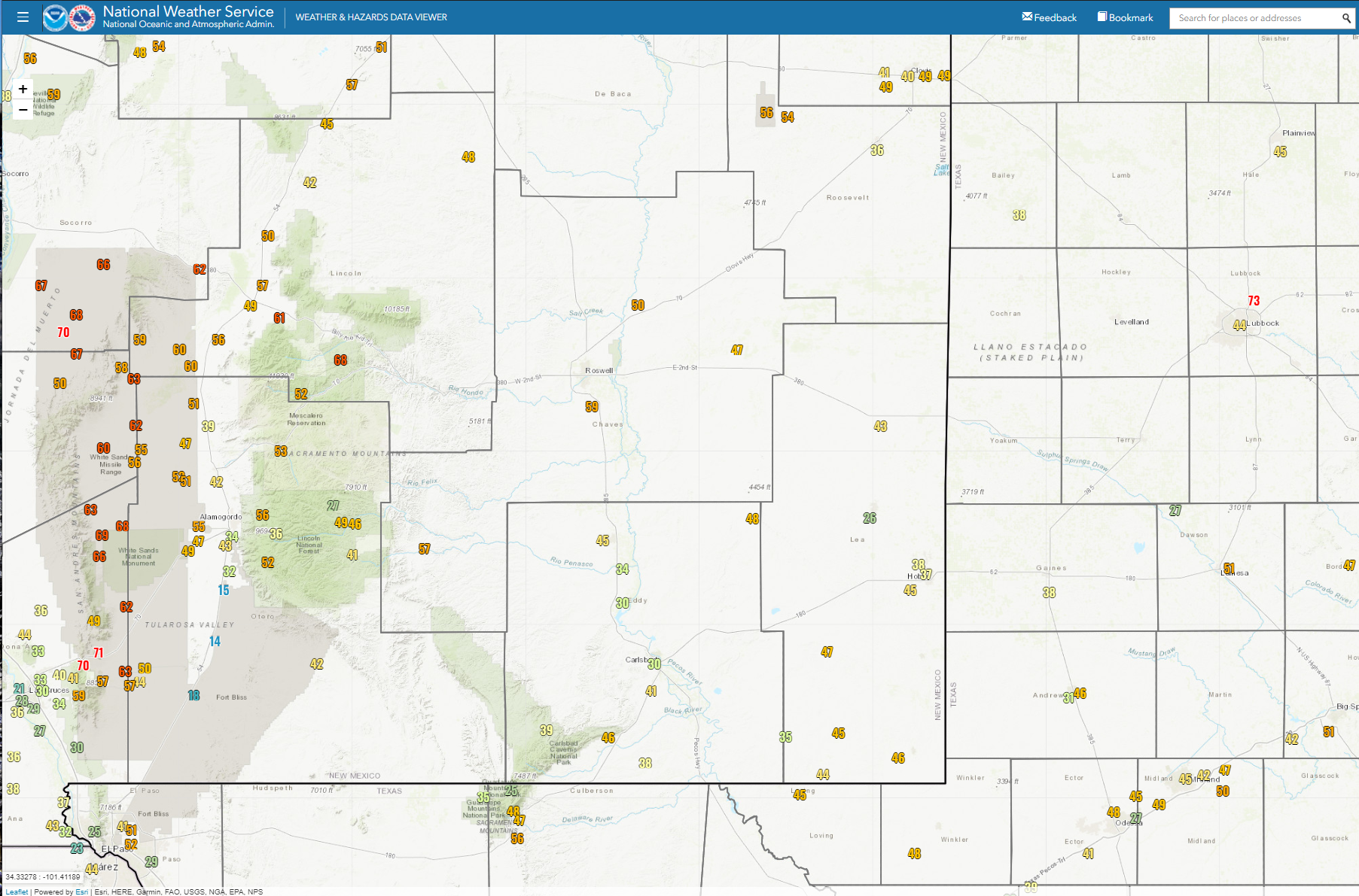
Public Information Statement
National Weather Service Albuquerque NM
729 AM MDT Sat Apr 23 2022

...HIGHEST WIND GUST REPORTS FROM APRIL 22, 2022...

Location                     Speed     Time/Date

...New Mexico...

...Bernalillo County...
Albuquerque Intl Sunport     64 MPH    0308 PM 04/22
Double Eagle II Arpt         62 MPH    0347 PM 04/22
Cedro 4 WSW (Sandia Lab)     54 MPH    0653 PM 04/22
Albuquerque 7 NW             52 MPH    0400 PM 04/22
I-40 Sedillo Hill (NMDOT)    52 MPH    0655 PM 04/22
Sedillo 1 S                  48 MPH    0209 PM 04/22
Albuquerque 2 N              47 MPH    0330 PM 04/22
Albuquerque 6 NW             47 MPH    0745 PM 04/22
Albuquerque 6 W              46 MPH    0508 PM 04/22
Carnuel                      46 MPH    0526 PM 04/22
Albuquerque 5 E              43 MPH    0325 PM 04/22
Albuquerque 6 ENE            43 MPH    0505 PM 04/22
Ponderosa 2 NNW (Oak Flats)  43 MPH    0704 PM 04/22
Albuquerque 4 NE             41 MPH    0401 PM 04/22

...Catron County...
Old Horse Springs 19 SSE (Pe 63 MPH    0538 PM 04/22
Mogollon 1 WSW (Mogollon)    49 MPH    0313 PM 04/22
Mogollon 34 ESE (Gila Center 47 MPH    0613 PM 04/22
Reserve 1 WSW                47 MPH    0408 PM 04/22
Beaverhead                   46 MPH    0408 PM 04/22
Luna 1 ENE (Luna)            45 MPH    0407 PM 04/22

...Chaves County...
Roswell Air Center           60 MPH    0418 PM 04/22
Dunken 2 NE (Dunken)         57 MPH    0436 PM 04/22
Bitter Lake WL Refuge 14 NNE 50 MPH    0537 PM 04/22
Roswell No. 1 Portable       47 MPH    0440 PM 04/22

...Cibola County...
I-40 at NM-6 (NMDOT)         62 MPH    0404 PM 04/22
El Morro 16 SSE (Malpais Lav 60 MPH    0325 PM 04/22
1 N New Laguna (Laguna)      56 MPH    0233 PM 04/22
Pine Hill 14 SSE             53 MPH    0334 PM 04/22
Bluewater Lake 9 SSW (Bluewa 52 MPH    0205 PM 04/22
Grants-Milan Airport         52 MPH    0235 PM 04/22
19 SW Acoma Pueblo (Brushy M 51 MPH    0449 PM 04/22
San Mateo 6 SSW (Grants)     43 MPH    0316 PM 04/22

...Colfax County...
Raton Crews Airport          81 MPH    0716 PM 04/22
Angel Fire Airport           58 MPH    0615 PM 04/22

...Curry County...
Clovis Muni Airport          53 MPH    0409 PM 04/22
Cannon AFB                   51 MPH    0332 PM 04/22
Clovis                       49 MPH    0458 PM 04/22
Clovis ASC (NMCC)            43 MPH    0645 PM 04/22
Clovis                       40 MPH    0546 PM 04/22

...De Baca County...
1 ENE Fort Sumner            55 MPH    0405 PM 04/22
Sumner Lake 1 NW             45 MPH    0607 PM 04/22

...Guadalupe County...
Santa Rosa Airport           56 MPH    0815 PM 04/22
Milagro 3 ESE                49 MPH    0715 PM 04/22
Vaughn 4 E (UPR)             44 MPH    1114 AM 04/22

...Harding County...
Mills 4 WSW (Mills Canyon)   52 MPH    0705 PM 04/22

...Lincoln County...
Sierra Blanca Rgnl Arpt      68 MPH    0315 PM 04/22
Pole 616 (WSMR)              63 MPH    0635 PM 04/22
Nogal 5 NW                   61 MPH    1255 PM 04/22
Oscura Range Camp (WSMR)     60 MPH    0635 PM 04/22
Shist (WSMR)                 59 MPH    0605 PM 04/22
Phillips Hill (WSMR)         58 MPH    0355 PM 04/22
Carrizozo 6 NE (UPR)         57 MPH    0118 PM 04/22
Ruidoso 1 NNW (Smokey Bear)  52 MPH    0100 PM 04/22
Carrizozo 1 WNW              49 MPH    0631 PM 04/22
Roswell No. 2 Portable       46 MPH    0620 PM 04/22
Oscuro 4 NE (UPR)            41 MPH    1133 AM 04/22
Ancho 6 SW (UPR)             40 MPH    0118 PM 04/22

...Los Alamos County...
Los Alamos 5 SSW (LANL)      66 MPH    0400 PM 04/22
Los Alamos Airport           61 MPH    0435 PM 04/22
Los Alamos 3 ESE (LANL)      60 MPH    0400 PM 04/22
White Rock 1 WNW (LANL)      60 MPH    0400 PM 04/22
Los Alamos 2 E               56 MPH    0445 PM 04/22
White Rock                   55 MPH    0437 PM 04/22
Los Alamos 2 SSW (LANL)      46 MPH    0215 PM 04/22

...McKinley County...
Gallup Airport               70 MPH    0111 PM 04/22
Zuni Pueblo 7 NW (Zuni Butte 56 MPH    0242 PM 04/22

...Quay County...
Tucumcari Muni Airport       64 MPH    0330 PM 04/22
Endee 2 SW                   57 MPH    0425 PM 04/22
Tucumcari ASC (NMCC)         41 MPH    0635 PM 04/22

...Rio Arriba County...
Espanola 4 NW (Black Mesa)   60 MPH    0534 PM 04/22
12 SSW El Vado (Deadman Peak 57 MPH    0207 PM 04/22
Alcalde ASC (NMCC)           45 MPH    0710 PM 04/22
Monero 12 S (Stone Lake)     45 MPH    0333 PM 04/22
Dulce (Dulce No. 2)          44 MPH    0428 PM 04/22
Canon Plaza 4 E (Jarita Mesa 43 MPH    0516 PM 04/22
Truchas 3 ENE (Truchas)      43 MPH    0511 PM 04/22
El Vado 11 W (NMJIA_PORT1)   42 MPH    0734 PM 04/22

...Roosevelt County...
Tolar 13 SE (Melrose Range)  54 MPH    0614 PM 04/22

...San Juan County...
Farmington Airport           71 MPH    0337 PM 04/22
Bloomfield                   70 MPH    0259 PM 04/22
4 SE Chaco Canyon National H 60 MPH    0240 PM 04/22
Farmington ASC (NMCC)        48 MPH    0330 PM 04/22
Navajo Dam 12 N (Albino Cany 47 MPH    0526 PM 04/22
Farmington                   45 MPH    0331 PM 04/22
Bloomfield 4 E (UCC-AGNET)   44 MPH    0415 PM 04/22
Farmington 1 NE              44 MPH    0335 PM 04/22
Farmington 2 WSW             43 MPH    0344 PM 04/22

...San Miguel County...
Las Vegas Muni Airport       74 MPH    0411 PM 04/22
Apache Springs 1 NE          64 MPH    0629 PM 04/22
Lower Colonias 5 E (Pecos)   51 MPH    0514 PM 04/22
Bell Ranch 11 ENE            40 MPH    0825 PM 04/22

...Sandoval County...
Frijoles (Tower)             63 MPH    0508 PM 04/22
Nmspa_port1                  55 MPH    0353 PM 04/22
Cuba 9 SW (Cuba)             54 MPH    0341 PM 04/22
Valle Toledo (DRI)           50 MPH    0350 PM 04/22
Jemez Springs (DRI)          47 MPH    0350 PM 04/22
Jemez Springs                46 MPH    0246 PM 04/22
Rio Rancho 3 NE              45 MPH    0400 PM 04/22
Rio Rancho 2 S               44 MPH    0432 PM 04/22
Rio Rancho 2 SW              43 MPH    0422 PM 04/22
San Antonio (DRI)            43 MPH    0110 PM 04/22
Placitas 6 SE                40 MPH    0500 PM 04/22

...Santa Fe County...
Santa Fe Muni Airport        70 MPH    0525 PM 04/22
Stanley                      64 MPH    0400 PM 04/22
Glorieta 6 WNW               60 MPH    0600 PM 04/22
Glorieta                     58 MPH    0408 PM 04/22
Santa Fe                     56 MPH    0530 PM 04/22
Santa Fe 3 ENE               49 MPH    0436 PM 04/22
Santa Fe 3 WNW               48 MPH    0515 PM 04/22
Santa Fe 7 SW                48 MPH    0545 PM 04/22
Edgewood 4 ENE               46 MPH    0516 PM 04/22
Tesuque                      46 MPH    0530 PM 04/22
Santa Fe 4 NW                45 MPH    0446 PM 04/22
Lamy 5 NW                    44 MPH    0545 PM 04/22
Santa Fe 1 WNW               44 MPH    0538 PM 04/22
Edgewood                     43 MPH    0540 PM 04/22
Santa Fe 3 NW                43 MPH    0507 PM 04/22
Santa Fe 2 SW                40 MPH    0330 PM 04/22

...Socorro County...
10 SSE Magdalena             75 MPH    0315 PM 04/22
Harry (WSMR)                 70 MPH    0450 PM 04/22
Stallion WIT (WSMR)          68 MPH    0355 PM 04/22
Sulf (WSMR)                  67 MPH    0350 PM 04/22
Zumwalt Track (WSMR)         67 MPH    0335 PM 04/22
Mine (WSMR)                  66 MPH    0345 PM 04/22
Magdalena 3 ENE              65 MPH    0346 PM 04/22
Stallion Runway (WSMR)       63 MPH    0200 PM 04/22
Carrizozo 15 NW (Chupadera)  62 MPH    0539 PM 04/22
Little Burro (WSMR)          62 MPH    0500 PM 04/22
Contreras 1 ESE (Sevilleta)  59 MPH    0511 PM 04/22
Socorro Airport              59 MPH    0415 PM 04/22
Las Nutrias 1 WNW            56 MPH    0230 PM 04/22
North Oscura Peak (WSMR)     54 MPH    0425 PM 04/22
VLA 16 SSE (Magdalena)       52 MPH    0503 PM 04/22

...Taos County...
8 S Red River                93 MPH    0600 PM 04/22
Taos Muni Airport            63 MPH    0546 PM 04/22
Lama 4 NW (Wild Rivers)      57 MPH    0349 PM 04/22
Arroyo Seco 3 SW             56 MPH    0430 PM 04/22
Talpa 1 NE                   56 MPH    0605 PM 04/22
Taos                         50 MPH    0345 PM 04/22

...Torrance County...
Clines Corners 1 SSE         70 MPH    0501 PM 04/22
Estancia 7 SSW               63 MPH    0315 PM 04/22
1 NE Abo                     61 MPH    0725 PM 04/22
Estancia 2 WSW               59 MPH    0436 PM 04/22
Moriarty Muni Airport        58 MPH    0355 PM 04/22
1 W Mountainair (Mountainair 54 MPH    0505 PM 04/22
Abo 3 N                      48 MPH    0300 PM 04/22
Corona Range LRC (NMCC)      47 MPH    0515 PM 04/22
Corona 1 NE (UPR)            40 MPH    0145 PM 04/22

...Union County...
Clayton Muni Airpark         68 MPH    0624 PM 04/22
Clayton LRC                  59 MPH    0620 PM 04/22

...Valencia County...
Belen Regional Airport       59 MPH    0315 PM 04/22
Tome 2 NNW                   53 MPH    0455 PM 04/22

Observations are collected from a variety of sources with varying
equipment and exposures. We thank all volunteer weather observers
for their dedication. Not all data listed are considered official.

$$
Public Information Statement
National Weather Service El Paso TX/Santa Teresa NM
1139 PM MDT Fri Apr 22 2022

...HIGHEST WIND REPORTS...

Location                     Speed     Time/Date       Lat/Lon
WSMR EMRE                    71 MPH    0945 PM 04/22   32.47N/106.50W
San Agustin Pass 1.6 E Organ 70 MPH    0615 PM 04/22   32.43N/106.57W
WSMR Building 1830           70 MPH    1020 PM 04/22   32.37N/106.47W
WSMR Pony                    69 MPH    0840 PM 04/22   32.87N/106.49W
WSMR Museum                  66 MPH    1050 PM 04/22   32.38N/106.48W
WSMR Rad                     66 MPH    0915 PM 04/22   32.80N/106.50W
Delta Clipper                66 MPH    0935 PM 04/22   32.90N/106.41W
Burro Mountain RAWS          64 MPH    0459 PM 04/22   32.67N/108.54W
South Franklin Peak          63 MPH    0949 PM 04/22   31.86N/106.49W
T-or-C ASOS                  63 MPH    0712 PM 04/22   33.23N/107.27W
WSMR LC-32                   63 MPH    0805 PM 04/22   32.41N/106.40W
Brillo West                  63 MPH    0100 PM 04/22   32.96N/106.54W
WSMR Apache                  62 MPH    0835 PM 04/22   32.63N/106.39W
WSMR Denver WIT              62 MPH    0635 PM 04/22   33.24N/106.36W
WSMR Jallen Hawk 40          60 MPH    0630 PM 04/22   33.17N/106.49W
Spaceport America Awos       59 MPH    0545 PM 04/22   32.99N/106.97W
Dripping Springs RAWS        59 MPH    0426 PM 04/22   32.32N/106.59W
Lordsburg Playa I10 MP12 (NM 59 MPH    0355 PM 04/22   32.29N/108.87W
Condron Field (WSMR)         59 MPH    1040 PM 04/22   32.34N/106.41W
Globe                        59 MPH    1040 PM 04/22   32.38N/106.47W
Arrey 2N                     58 MPH    0545 PM 04/22   32.88N/107.31W
WSMR Alt Shist               58 MPH    0435 PM 04/22   33.44N/106.41W
Lordsburg Playa I10 MP11 (NM 57 MPH    0355 PM 04/22   32.28N/108.88W
WSMR C-Station               57 MPH    0835 PM 04/22   32.36N/106.38W
WSMR Main Post               57 MPH    1020 PM 04/22   32.37N/106.49W
High Rolls                   56 MPH    0819 PM 04/22   32.94N/105.84W
WSMR Salt Creek              56 MPH    0735 PM 04/22   33.12N/106.36W
Biggs Field AWOS             55 MPH    0839 PM 04/22   31.85N/106.38W
Deming ASOS                  55 MPH    0550 PM 04/22   32.27N/107.72W
Lordsburg Playa I10 MP13 (NM 55 MPH    0355 PM 04/22   32.32N/108.81W
WSMR ABC-1                   55 MPH    0625 PM 04/22   33.16N/106.33W
Malone                       55 MPH    0540 PM 04/22   32.90N/106.10W
North Lordsburg Playa        54 MPH    0445 PM 04/22   32.25N/108.95W
Chiricahua Desert Museum     53 MPH    0310 PM 04/22   31.87N/109.02W
Silver City - Mountain View  53 MPH    0615 PM 04/22   32.77N/108.26W
Mescalero RAWS               53 MPH    0641 PM 04/22   33.16N/105.77W
Lordsburg Playa I10 MP7 (NMD 53 MPH    0350 PM 04/22   32.25N/108.93W
Lc-35 North                  53 MPH    0945 PM 04/22   32.44N/106.34W
Grant County Airport AWOS    52 MPH    0555 PM 04/22   32.63N/108.15W
WSMR Tula                    52 MPH    0740 PM 04/22   33.07N/106.18W
Silver City - Viento Ridge   51 MPH    0503 PM 04/22   32.77N/108.33W
Hachita Valley               51 MPH    0440 PM 04/22   31.70N/108.34W
El Paso International Airpor 51 MPH    0948 PM 04/22   31.82N/106.38W
WSMR Tula Airstrip           51 MPH    0740 PM 04/22   33.06N/106.15W
Russ                         51 MPH    0735 PM 04/22   33.32N/106.12W
WSMR Rob                     50 MPH    0210 PM 04/22   33.39N/106.66W
Mayhill - Dimension Point Ob 49 MPH    0630 PM 04/22   32.91N/105.53W
El Paso NE - K5IA            49 MPH    1129 PM 04/22   31.91N/106.41W
Holloman AFB AWOS            49 MPH    0418 PM 04/22   32.85N/106.08W
San Andres RAWS              49 MPH    0701 PM 04/22   32.58N/106.53W
Winston (EPZWxNet)           48 MPH    0608 PM 04/22   33.35N/107.65W
Hanover 5ENE                 47 MPH    0500 PM 04/22   32.82N/108.00W
WSMR Frequency               47 MPH    0550 PM 04/22   32.82N/106.15W
WSMR Rita                    47 MPH    0620 PM 04/22   33.18N/106.15W
Mayhill RAWS                 46 MPH    0501 PM 04/22   32.91N/105.47W
Santa Teresa NWS RSOIS       46 MPH    0535 PM 04/22   31.87N/106.70W
WSMR LC-36                   46 MPH    0530 PM 04/22   32.42N/106.32W
El Paso NE - KB5HPT          45 MPH    1130 PM 04/22   31.92N/106.43W
Las Cruces AWOS              45 MPH    0215 PM 04/22   32.27N/106.92W

Observations are collected from a variety of sources with varying
equipment and exposures. We thank all volunteer weather observers
for their dedication. Not all data listed are considered official.

$$
The Truth Is Stranger Than Fiction!


Comments
Post a Comment
Your comments, questions, and feedback on this post/web page are welcome.