

High End Widespread Damaging Wind/Blowing Dust/Fire Event - Severe T-Storms Tonight!

Sierra Blanca Peak West Of Ruidoso, NM.
Catastrophic High Wind/Blowing Dust/Fire Weather Event Today!
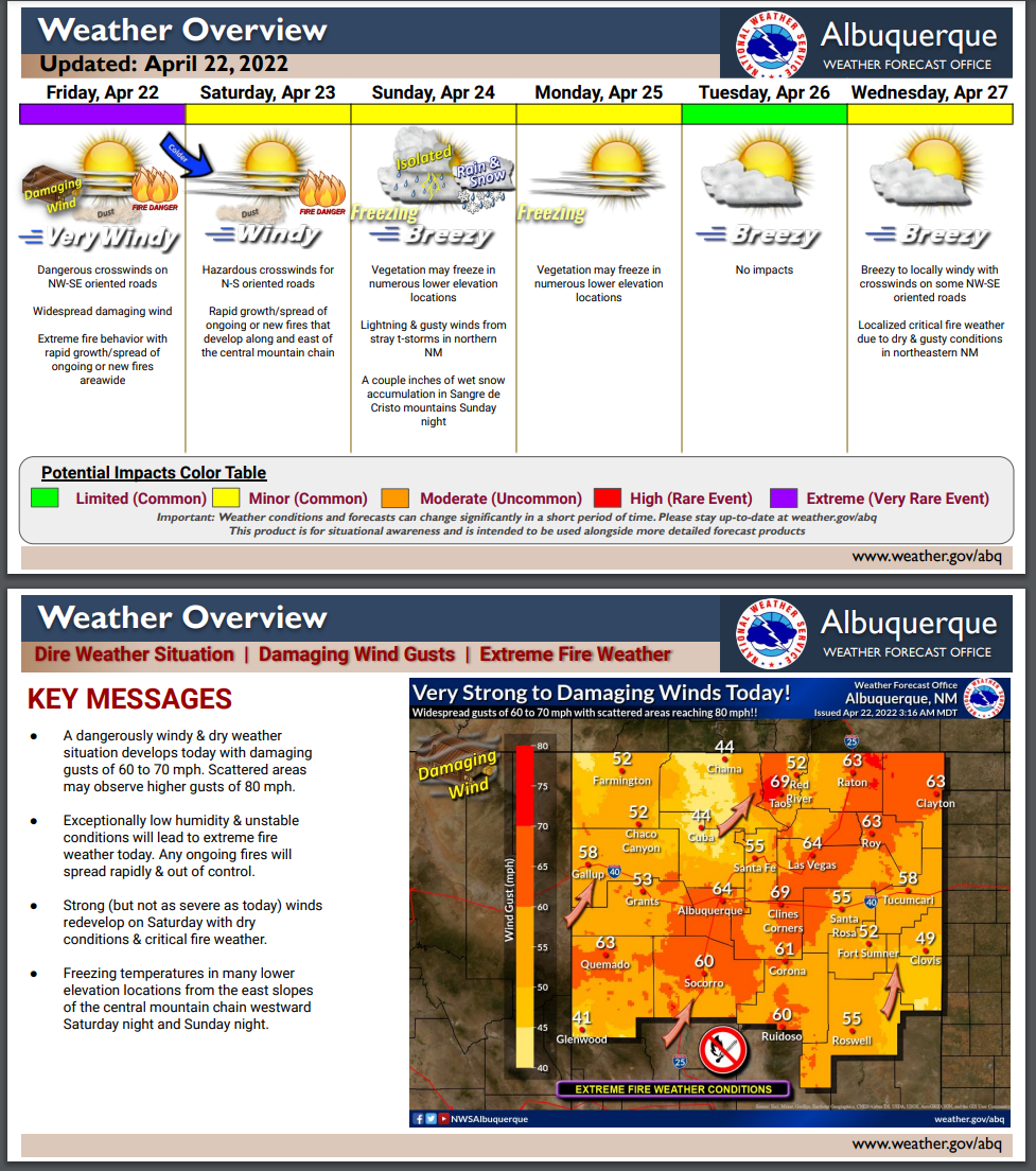

High Wind Warnings, Watches, and Wind Advisories cover much of New Mexico and the area today into this evening. Southwest winds will crank up with a vengeance mid-morning and increase throughout the day. Current thinking is that the highest wind gusts and associated wind damage will occur across central, northern, and northeastern New Mexico where some gusts may reach or exceed 80 mph!
Elsewhere we can expect to see southwesterly winds gusting up to around 60-70 mph across parts of southern New Mexico, the Sacramento and Capitan Mountains, and the eastern plains. Southeastern New Mexico is expected to see these winds gust up to around 55 mph. A few locally higher gusts are certainly possible. The Guadalupe Mountains will see southwesterly wind gusts of around 70 mph.
Wind damages start occurring with the highest gusts generally above 60 mph. Trees and tree limbs may be blown down, and in some cases onto power and utility lines. This will be more widespread in the mountains. These downed lines will have the potential to start grass, rangeland, and forest fires. Given our recent local history and ongoing fires this will be disastrous should they occur. Life and property could be threatened. Heed immediately any education orders that are given should this unfold.
Any fire that develops today will be almost if not impossible to control and will spread rapidly in the high winds. Dense smoke from any fire combined with blowing dust near roadways and highways will only compound travel issues. Some road closures are possible.
Widespread blowing dust is forecast for the state and much of the area today. In fact, a Blowing Dust Advisory has just been issued for Dona Ana, Otero, and El Paso Counties from noon today into 8 PM MDT this evening. Localized areas of dense blinding dust will occur during the strongest gusts. This will be especially true over and near the following locations: Freshly plowed or exposed farmland, fields, lots, highway construction sites, and other normally dust-prone areas.
Be prepared for sudden drops in the visibility at times to zero or near zero with little to no advanced warning on some of our local roads and highways, especially this afternoon and evening. Travel may and likely will become dangerous and difficult, if not impossible at times due to these dangerous crosswind gusts and blinding dust storms.
Be prepared for sudden drops in the visibility at times to zero or near zero with little to no advanced warning on some of our local roads and highways, especially this afternoon and evening. Travel may and likely will become dangerous and difficult, if not impossible at times due to these dangerous crosswind gusts and blinding dust storms.
Normally our local National Weather Service Forecast Office Meteorologists in Midland/Odessa, Albuquerque, El Paso/Santa Teresa, and Lubbock don't get all that aminated in their daily Area Forecast Discussions (AFD's). This is not the case this morning with the Albuquerque Office. Clearly the forecasters there are quite concerned about today's upcoming extreme weather across New Mexico. The only thing I would add is that sadly this potentially could be a historic event and one for the record books in parts of New Mexico and the area.
Severe Thunderstorms This Afternoon & Evening.


Severe Thunderstorms This Afternoon Into These Evening.
Throughout my lifetime of watching, observing, reporting, and chasing our local weather there have been similar events such as what is expected today that stick in my memory. Blinding dust storms driven by 60 mph or higher southwesterly wind gusts, wind damages, and wildfires. More than once I've observed discrete supercell thunderstorms or squall lines forming along the caprock or NM/TX state line close to sunset along and east of the dryline through these dust storms. I think today will add to my memories.
As outlined in the maps above severe thunderstorms are forecast to develop this afternoon and evening...east of the Pecos Valley into West Texas. Large hail (some very large), damaging thunderstorm wind gusts, frequent deadly cloud to ground lightning, and a few tornadoes will all be possible with any supercell thunderstorm that develops. I haven't made my mind up yet as to whether or not I will be chasing dust storms or supercells this afternoon. Maybe both. Be safe everyone and stay weather aware...your life may depend upon it!
By the way, my dew point temperature on my Davis Vantage Pro2+ Wireless weather station at 8:13 AM MDT this morning is 62. Low stratus clouds are forming overhead here in Carlsbad so the dryline is west of us.
By the way, my dew point temperature on my Davis Vantage Pro2+ Wireless weather station at 8:13 AM MDT this morning is 62. Low stratus clouds are forming overhead here in Carlsbad so the dryline is west of us.
Area Forecast Discussion...UPDATED
National Weather Service Albuquerque NM
520 AM MDT Fri Apr 22 2022
.PREV DISCUSSION...251 AM MDT Fri Apr 22 2022...
.SYNOPSIS...
A dire situation will take shape today as very strong to damaging
winds will develop across much of northern and central New Mexico.
While windy conditions are common this time of year, today will be
different with widespread gusts of 60 to 70 mph, and several
locations are expected to observe even higher gusts near 80 mph.
In addition to these severe winds, very dry air and low humidity will be
present, leading to extreme fire weather. This will mean that any
ongoing wildfires or new fire starts will grow rapidly and likely out
of control with catastrophic results possible. Everyone is urged to be extremely cautious. Avoid outdoor burning, avoid the use of
outdoor power equipment that may produce a spark, avoid parking your
vehicle in tall grass, and ensure that trailer chains are properly
stowed. These are just a few precautions that can help reduce new
wildfire starts in this very dangerous weather situation. ...A DIRE WEATHER SITUATION EXPECTED TODAY AS VERY STRONG TO DAMAGING WINDS DEVELOP ALONG WITH EXCEPTIONALLY LOW HUMIDITY THAT WILL CREATE EXTREME FIRE WEATHER CONDITIONS... .DISCUSSION...SHORT TERM...(TODAY THROUGH SATURDAY)...The stage is set for an incredibly strong wind event across New Mexico today. A deep upper level trough is crossing CA early this morning with satellite derived 250mb winds reaching 90-100kts over UT. This jet max shifts eastward over the state this afternoon, with model guidance continuing to show a 50-60kt H7 speedmax overhead. Deep layer mixing to the H6 level, combined with a rapidly deepening sfc low of 980mb MSLP over northern CO will translate and enhance these winds to the surface across the entire forecast area beginning mid-morning and peaking in strength during the afternoon. Peak gusts of 50-60mph are possible areawide, with 70-80mph possible along the highlands adjacent to the central mountain chain. Forecast confidence is near as high as it can be with this set up and High Wind Warnings are looking good to go. The one crux is the how strong winds get with the Pacific fropa late in the day and after 00Z, with the latest model runs showing high wind speeds of 40-45mph sustained possible where there are wind advisories over the southeastern plains. Since these wind speeds look to be short-lived and associated with the fropa, will forego an upgrade to high wind for these zones at this time. However, cannot rule out the high wind potential here and perhaps an upgrade will be needed the closer we get to this event. Widespread blowing dust and strong crosswinds on all area highways will create particular dangerous travel conditions today. This will be especially true for high profile vehicles. Power outages will also be possible from downed tree limbs or other high wind related damage.
The Truth Is Stranger Than Fiction!


Comments
Post a Comment
Your comments, questions, and feedback on this post/web page are welcome.