My Blog Archive List (July 2010 - August 2025).

Show more

Cannon AFB (KFDX) Radar Outage

Updated 10/01/2025 11am The Cannon Air Force Base (KFDX) WSR-88D will remain inoperable for an extended period due to a hardware failure at the site. Parts have been ordered. There is currently no estimate on when the radar will return to service. KFDX radar is the only radar coverage for portions of eastern New Mexico. However, you may find KPUX, KAMA, KLBB, and KMAF radars useful. If you have questions or concerns, please contact Cannon AFB Public Affairs at 575-784-4131.

Viewing My Web Page

If you are viewing my web page on your cell phone, then be sure and click on the three white bars located in the top left-hand corner of the page (only visible on your phone). This is the menu bar, and it opens up additional links and graphics. Such as forecast maps, severe weather outlooks, current conditions, radar and satellite links, and more.

Golf Ball Size Hail In NW El Paso Last Night - Severe T-Storms Possible Today!

Tuesday, April 26, 2022, At 10:47 PM MDT.

(Tuesday, April 26, 2022).


(As Of 8:30 AM MDT Wednesday).


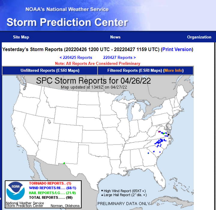
Severe Thunderstorms In Northwest El Paso Last Night.

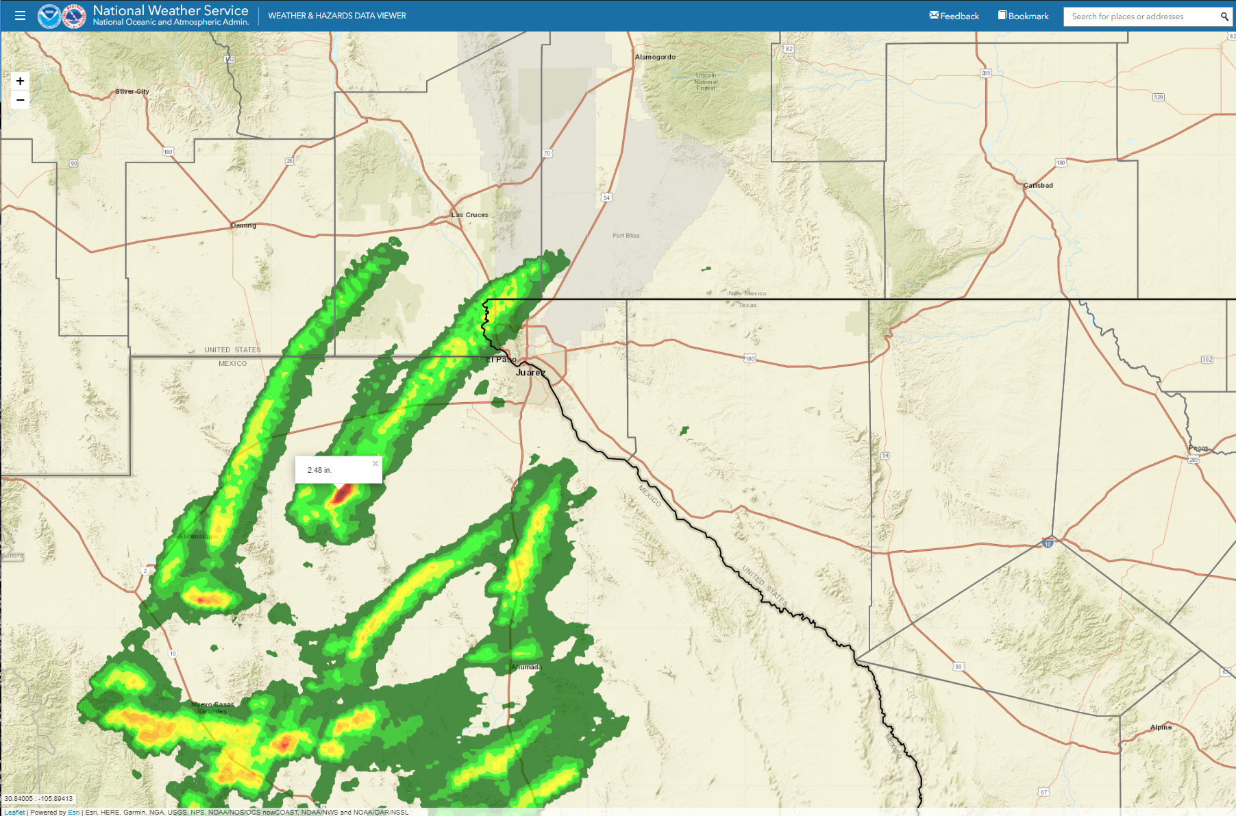
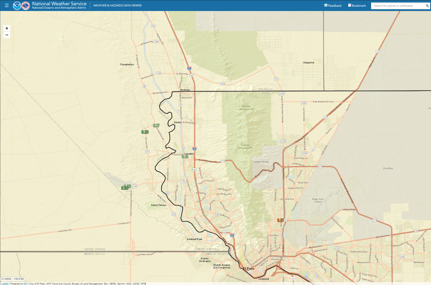
A cluster of thunderstorms moved out of northern Mexico, southwest of El Paso, and northeastward into northwestern El Paso around 10:30 PM MDT last night. A severe thunderstorm warning was issued by the Santa Teresa/El Paso National Weather Service Office for southcentral Dona Ana and northwestern El Paso Counties at 10:38 PM MDT last night.

Spotters reported hail ranging in size from quarters (1" diameter) to golf balls (13/4" diameter) in the northwestern parts of the city. Rainfall totals ranged from around .20" to .50" of an inch.

Severe T-Storms Possible Today!


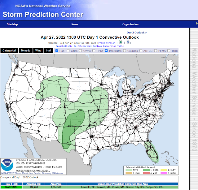
A few dryline thunderstorms are forecast for the area this afternoon and evening. A few of these may develop into slow-moving supercells and produce marginally severe hail to severe hail and damaging thunderstorm wind gusts in excess of 58 mph. Frequent deadly cloud-to-ground lightning will accompany any thunderstorms that form. Locally moderate to heavy rainfall is also possible with the strongest of these thunderstorms. Widespread rainfall is not expected.

The Truth Is Stranger Than Fiction!

Comments

Current US Hazardous Weather Watch/Warning Map

New Mexico

Eddy County

Guadalupe Mtns Eddy & Culberson County

Chaves County Plains & Mtn's

Lea County

Lincoln County

Otero County

Pagosa Springs, Colorado Flooding Oct 12, 2025

Arizona Flooding - Oct 12, 2025

🔴 Live 24/7 National Weather Radar & Alerts, Weather Intensity Score & YallBot!

Ruidoso Live Webcam

Ski Apache Webcam Live Link

Ski Apache Webcam Live Link
Click On The Image To Open It Up

Cloudcroft Live Webcam

Roswell Live EarthCam

New Mexico Weather Tweets

Average Daily High/Low Temperatures & Rainfall/Snowfall

My Rainfall Totals. 2.1 NNW Downtown Carlsbad, NM.

Top 10 Most Popular Posts

Artesia, NM Mothership Supercell Thunderstorm. 9-17-2016.

Monster Of A Snowstorm Coming This Christmas Weekend?

Powerful Winter Storm Is Hammering New Mexico! Worst Is Yet To Come.

25th Anniversary Of The Carlsbad, NM (May 31, 1991) Tornado Coming Up.

Major Winter Storm May Paralyze/Bury Parts Of NM & Nearby Areas Tonight Into Wednesday!

2011 Skywarn Spotter Training Classes & My Thoughts.

Tonight's GFS Is As Drunk As This Mornings ECMWF. Historic Snowstorm Next Weekend?

Are We Fixing To Go From Drought To Flood In SE NM?

Major Winter Storm To Hammer New Mexico & West Texas Thanksgiving Week!

Cloudcroft & Ruidoso, NM Seasonal Snowfall Totals.

My Favorite Blog List.

Substack

Disclaimer

This blog and its contents are for informational purposes only! Always have multiple sources of information available to rely upon during severe weather. Do not rely solely on the Internet. Be weather-aware, plan ahead, have a backup plan, and be ready to act before severe weather strikes your location.