

Multi-Day High Wind-Blowing Dust-Critically/Extremely Dangerous Fire Weather Threats.
Blog Updated At 4:56 PM MDT Sunday.

Cloudcroft Ski Slopes.

Surface Map Forecast.
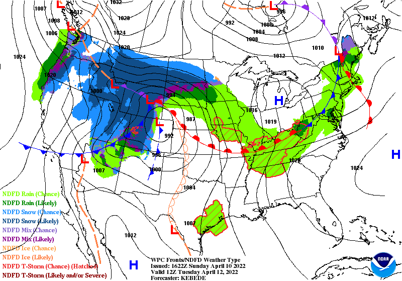

A deep and cold mid-upper level trough of low pressure will cover the western half of the nation at sunset Tuesday. In response, a deep surface low (979 millibars or 28.91") is forecast to be located over northwestern Kansas and southwestern Nebraska Tuesday afternoon. This will result in a very tight surface pressure gradient across the central plains extending southwest into New Mexico. With strong winds aloft, deep mixing of the atmosphere, and above normal temperatures multiple days of high winds are forecast for our local area today into Wednesday.
Note that these mid-level storms are not digging as far south into the Four Corners area as has been the case the past fall and winter. This means that the jet stream is starting to retreat northward. And in time a strong ridge of high pressure will dominate our weather continuing the drought and more hot weather.
Today.

Monday.

Tuesday.

(At 6 PM MDT Each Day).
Today.

Monday.

Tuesday.
Multi-Day Critically/Extremely Dangerous Fire Weather Conditions!


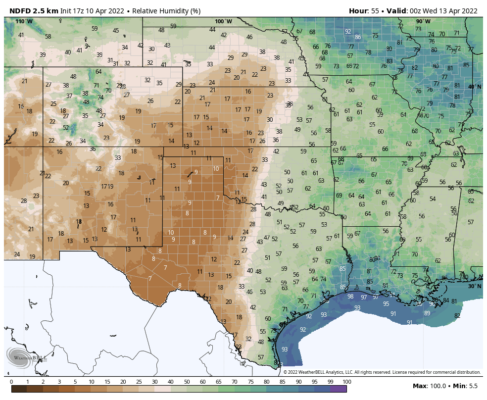
Above normal temperatures, windy to very windy conditions, single-digit relative humidity values, and the continued extreme to exceptional drought conditions will all combine to continue the threat for dangerous fire weather conditions today into Wednesday.
Critically Dangerous to Extremely Critically Dangerous Fire Weather Conditions are forecast today into Tuesday. Please avoid any type of outdoor activity that involves the use of sparks or flames. Red Flag Warnings and Fire Weather Watches continue in effect today into Tuesday areawide.
Any wildland, rangeland, grass, or forest fires that potentially could develop will be difficult if not impossible to contain or control and will spread rapidly in the high winds. Large uncontrollable rapidly advancing fires are possible which will have the potential to threaten life and property today into Wednesday...but especially on Tuesday. There have been some comparisons made recently of conditions now similar to April 2011 locally.
Tuesday is shaping up to be an especially worrisome day given the forecast of widespread high winds. Once again the combination of thick smoke and blinding dust storms could potentially shut down some local roadways and highways with near to zero visibility with little to no advanced warning.
A number of fires have already occurred in parts of the area so far this spring and we have a long way to go before the threat ends.
Significant High Wind/Damaging Wind Event Possible Tuesday.
Southwest to west winds are forecast to gust up to around 35 mph this Sunday afternoon across the Southeastern Plains, parts of West and Far West Texas, and southern New Mexico. Winds will be a little stronger on Monday with gusts near 40-50 mph locally.
Southwest to west winds are forecast to gust up between 50-60 mph this Sunday afternoon across the Sacramento, Capitan, and Guadalupe Mountains. Wind Advisories remain in effect through early this evening.
A High Wind Warning remains in effect for the Guadalupe Mountains today through 2 AM MDT Monday morning. A High Wind Watch remains in effect for the Guadalupe Mountains for Monday. A Wind Advisory is now in effect for Eddy County on Monday.
A High Wind Warning remains in effect for the Guadalupe Mountains today through 2 AM MDT Monday morning. A High Wind Watch remains in effect for the Guadalupe Mountains for Monday. A Wind Advisory is now in effect for Eddy County on Monday.
Tuesday is shaping up to be a really ugly day with southwesterly to westerly wind gusts of 80 mph or higher possible in the Guadalupe Mountains. 60-70 mph gusts in the Sacramento and Capitan Mountains, and 55-65 mph or higher gusts are possible across the Southeastern Plains.
Typically we start to see damages from these winds around the 60 mph threshold. Downed power lines from the high winds on Tuesday could potentially be disastrous for the area creating the possibility of fires.
Blowing Dust Threat Increases Going Into Tuesday.
Localized areas of blowing dust areawide are possible today into Wednesday. Blinding dust storms may rake the area, especially on Tuesday. Our normally prone dust storm locations such as freshly plowed or exposed farmlands, open fields, lots, highways, and other construction sites will have the worst conditions and lowest visibilities in the blowing dust. Remember that the local area has a long history of vehicle accidents on our roads and highways due to blinding dust storms. Some with injuries and fatalities.
Today.

Monday.
Tuesday.

Wednesday.

Thursday Morning Low Temperatures.

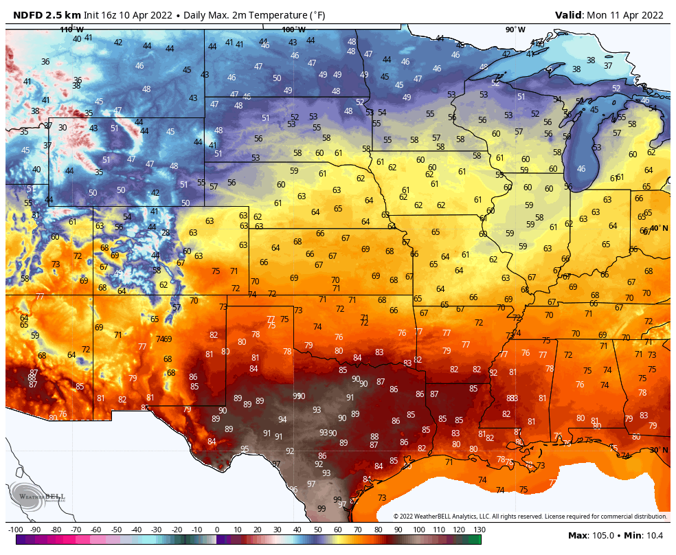
Above normal temperatures are forecast to continue into Wednesday until after the next Pacific cold frontal passage. Next Thursday morning will see widespread below-freezing temperatures for much of New Mexico and the local area.

The Truth Is Stranger Than Fiction!


Comments
Post a Comment
Your comments, questions, and feedback on this post/web page are welcome.