My Current Weather

Tuesday, August 30, 2022

Local SE NM 24-Rainfall Totals - 8-30-2022.


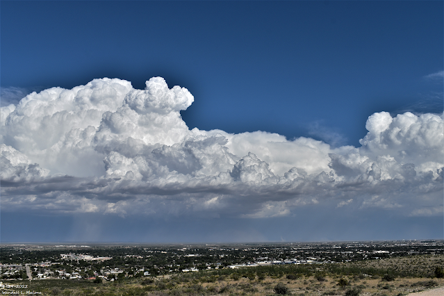
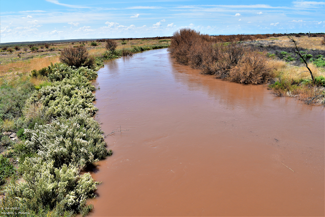
Monday, August 29, 2022.
Looking SE From C-Hill In Carlsbad.

(As Of 9 AM MDT Tuesday Morning).


(As Of 9 AM MDT Tuesday Morning).


(As Of 9 AM MDT Tuesday).


Local 24-Hour Rainfall Totals.

Yesterday afternoon thunderstorms produced localized heavy rainfall. The heaviest rainfall fell just north of Red Bluff Reservoir on the New Mexico/Texas State Line southeast of Carlsbad. Estimates as high as 5" may have fallen. 

Another pocket of heavy rainfall fell 20 miles east of Carlsbad just northwest of the WIPP Site. Both of these totals noted above may be a little high since radar indicated that the thunderstorms that produced this heavy rainfall also were producing hail. Hail tends to exaggerate the estimated rainfall totals in a storm.

A second complex/line of thunderstorms developed north of Roswell after sunset and moved south and southwest into the Pecos Valley before midnight. The heaviest estimated rainfall was noted just north of Dexter and southwest of Bottomless Lakes State Park where 2.50" may have fallen. A public report of 1.60" was posted on Facebook from Dexter. A Personal Weather Station (PWS - Grimmie) just north of Dexter measured 1.53".

A Roswell CoCoRaHS Station located 0.3 miles south-southwest recorded .99". An Artesia CoCoRaHS Station located 3.5 miles north-northeast recorded .92". The Roswell Airport ASOS measured .87". 

Monday afternoon a strong thunderstorm dumped 1.47" of rain at the Weed Personal Weather Station (PWS - Dark Ridge Observatory).


Public Information Statement
National Weather Service Albuquerque NM
921 AM MDT Tue Aug 30 2022

...PRECIPITATION REPORTS...

Location                     Amount    Time/Date       Lat/Lon

...New Mexico...

...Chaves County...
Roswell 40.5 NE              1.29 in   0800 AM 08/30   33.72N/103.96W
Roswell No. 1 Portable       1.00 in   0840 AM 08/30   33.50N/103.92W
Roswell 0.3 SSW              0.99 in   0700 AM 08/30   33.37N/104.53W
Roswell Air Center           0.87 in   0851 AM 08/30   33.30N/104.50W
Roswell 28.5 NNE             0.76 in   0700 AM 08/30   33.76N/104.36W
Roswell 5.5 E                0.70 in   0700 AM 08/30   33.38N/104.43W
Bitter Lake WL Refuge 14 NNE 0.42 in   0837 AM 08/30   33.65N/104.32W
Bitter Lake WL Refuge 14 NNE 0.40 in   0837 AM 08/30   33.65N/104.32W
Bitter Lakes WL Refuge       0.35 in   0602 AM 08/30   33.48N/104.40W
Roswell 5.1 N                0.30 in   0800 AM 08/30   33.44N/104.52W
Roswell 1.7 NW               0.23 in   0529 AM 08/30   33.39N/104.55W

...Lincoln County...
Arabela 2.5 SSW              0.21 in   0700 AM 08/30   33.55N/105.19W
Ruidoso 2 SSW                0.16 in   0700 AM 08/30   33.36N/105.67W

...Mora County...
IRAWS 5                      0.19 in   0900 AM 08/30   35.89N/105.59W
Chacon 2.1 ENE               0.16 in   0700 AM 08/30   36.16N/105.34W

...Quay County...
San Jon                      0.36 in   0700 AM 08/30   35.11N/103.33W

...Rio Arriba County...
Alcalde 5.9 NE               0.21 in   0700 AM 08/30   36.15N/105.99W
Alcalde                      0.11 in   0630 AM 08/30   36.09N/106.06W

...Roosevelt County...
Elida 9.1 S                  1.04 in   0700 AM 08/30   33.81N/103.65W
Causey 11.0 S                0.59 in   0830 AM 08/30   33.71N/103.12W
Milnesand                    0.30 in   0700 AM 08/30   33.64N/103.34W

...San Miguel County...
Villanueva 0.5 SW            0.37 in   0800 AM 08/30   35.26N/105.37W
Apache Springs 1 NE          0.30 in   0909 AM 08/30   35.39N/105.18W
Rowe 2.7 NNW                 0.27 in   0700 AM 08/30   35.53N/105.70W
Mineral Hill 1 WNW           0.10 in   0700 AM 08/30   35.62N/105.43W

...Taos County...
Iraws 20                     0.29 in   0901 AM 08/30   36.06N/105.50W
Valdez 1 NNW                 0.22 in   0909 AM 08/30   36.56N/105.59W
Questa 1.1 NE                0.12 in   0700 AM 08/30   36.71N/105.58W

...Torrance County...
Encino 6 W                   0.64 in   0700 AM 08/30   34.63N/105.57W

...Union County...
Amistad 7.7 SW               0.44 in   0700 AM 08/30   35.86N/103.27W

Observations are collected from a variety of sources with varying
equipment and exposures. We thank all volunteer weather observers
for their dedication. Not all data listed are considered official.

$$
There Are None So Blind As Those Who "Will - Not" To See...107.

Sunday, August 28, 2022

Summary Of Pecos River & Arroyo Flooding In SE NM 8-28-2022.

August 26, 2022.
Flooding On The Pecos River - Bank Full.
US Hwy 82 Bridge 6 Miles East Of Artesia, NM.

Monday, August 22, 2022.
Looking West At Pecos River Flooding.
US Hwy 380 Bridge East Of Roswell, NM.

(From Flooding On The Pecos River & Arroyos).

Saturday, August 21, 2022.
Near Dexter, New Mexico.
Pecos River Flooding - High Water Rescue.


It appears that the Pecos River flood crest of 17.36' at 1:45 PM MDT on Sunday, August 21, 2022, might be a new record at the Acme Gauge northeast of Roswell. We will have to wait for the final review from the USGS to know for sure.


Initially, the forecast flood crest of the Pecos River at the Lake Arthur Gauge was 27' which would have been five feet above its historical record crest of 21.9' on September 24, 1941. The forecast crest was lowered down to around 20' but crested well below these forecasts at 13.37' at 3:45 PM MDT on Friday, August 26, 2022. 


Saturday, August 20, 2022.
Flash Flooding At Carlsbad Caverns National Park.

Flood waters in Dark Canyon near Whites City failed to reach Carlsbad even though the flood crest was 9.98' at 9 PM MDT Saturday, August 20, 2022.


Widespread moderate to heavy rainfall fell across all of the local area between Wednesday, August 17, and Monday, August 22, 2022. For area rainfall totals see my blog post on Wednesday, August 24, 2022. 

There Are None So Blind As Those Who "Will - Not" To See...107.

Wednesday, August 24, 2022

Torrential Rainfall & Flash Flooding In Southern-Southeastern-South Central New Mexico 8-17-22-2022.


August 20, 2022.
Flooded Fields Draining Into Rocky Arroyo.
Just North Of The Rocky Arroyo Bridge On US Hwy 285

August 20, 2022.
Many Flooded Arroyo's Near Here.
Just North Of The Rocky Arroyo Bridge On US Hwy 285

August 20, 2022.
Flooded Rocky Arroyo.
Looking East From The US Hwy 285 Bridge.

Saturday, August 20, 2022.
NM State Hwy 137 & Rocky Arroyo.

Monday, August 22, 2022.
US Hwy 380 Bridge East Of Roswell, NM.

August 22, 2022.
Pecos River Flooding.
US Hwy 380 Bridge East Of Roswell, NM.

(7:06 AM MDT August 21, 2022).


(7:10 AM MDT August 21, 2022).


Cannon Air Force Base Dual Pol Doppler Radar Rainfall Estimates.


(As Of 6 AM MDT August 22, 2022).


(As Of 9 AM MDT Sunday, August 21, 2022).

(Wednesday, August 17 through Monday, August 22, 2022).

(9 AM MDT Wednesday, August 17 through 9 AM MDT Monday, August 22, 2022).


New Mexico CoCoRaHS 6-Day Rainfall Totals.
(9 AM MDT Wednesday, August 17 through 9 AM MDT Tuesday, August 23, 2022).


Radar and satellite estimates as per the National Weather Service MRMS site show that 11.41" of rain fell in the area shaded by light blue in the maps above. North of Roswell on the east side of US Highway 285, east of mile markers 39-46, in northern Chaves County.

So far (as of Tuesday, August 23rd) I haven't been able to find any collaborating rainfall reports online to substantiate this. I'm not saying this didn't happen I just don't have anything other than this radar site to verify those rainfall totals. Given the historic flooding on the Pecos River that continues from north of Roswell to south of Artesia due in part to runoff from the excessive rainfall in that area, I personally think these estimates may be valid. No doubt there has to be a rancher or local in that area that actually measured what fell...we can hope right? But getting ahold of that info has been tough so far if in fact, someone did measure that much rain.

Historically New Mexico's official greatest 24-hour rainfall total as measured by the National Weather Service Climate Co-Op Station Network is 11.28" at Lake Maloya in Colfax County on May 19, 1955. 

I am 64 years old and have lived all of my life (except for my time in the US Navy and a short period afterward) in the Artesia, Lakewood, and Carlsbad areas. My mother and stepdad built a grocery store in Artesia in the early 1960's. Our business was predominately with the area ranchers and farmers through the mid 1980's when the family business was sold. I spent my younger years talking with these farmers and ranchers as they shopped in our store...listening to their stories of our floods, droughts, heat waves, winter storms, bitter cold outbreaks, dust storms, etc. Most of this generation has passed away now. 

More than once I've been told that local ranchers have measured rainfall totals (storm totals usually occur over several days to a week, or two) of 10 inches, 20 inches, and even as high as 30 inches of rain in and around the Guadalupe, Sacramento, and Capitan mountains. This has happened occasionally throughout the past 100+ years according to these folks, local newspaper articles, and in some cases in our historical climatology records. 

A  couple of recent cases in point. 

A historic rain event for the Guadalupe Mountains from September 9th-13th, 2013. 15.76 inches of rain was recorded during this period at the Pine Springs, GUMO Mesonet station near the National Park Visitor Center. 13.62 inches of rain fell on September 11th-12th (most of this in a 12-hour period during the early morning hours of the 12th). Flash flooding occurred in the Dark Canyon, Rocky Arroyo, and Black River basins on the 12th with many localized areas of high water along the arroyos on the north side of the Guadalupe Mountains. An impressive fourteen-foot rise of water on the Dark Canyon when it reached Carlsbad, New Mexico.


Another historic heavy rainfall and flash flood event occurred in September 2014. A farmer who lives two miles east of Malaga (southeast of Carlsbad) in southern Eddy County measured a storm total (14-day totals) rainfall amount of 25" from this event. Radar verified his totals also. Another total of 22.25" was measured nearby on Durante road one mile east of Malaga. Closer to town a storm total of 21.50" was measured on Derrick Rd & Old Cavern Highway south of Carlsbad. 


Selected Highest 5-Day Rainfall Storm Totals.
(August 17 through Tuesday, August 23, 2022).
Not A Complete List.

Serpentine Bend Ranch Near Carlsbad Caverns 8.00"+
(Courtesy Of Sandi Meador Wilkie).
Rain gauges ran over.

Sacramento Personal Weather Station (PWS) Cabin 7.76"
 Hay Canyon West Of Sacramento  Personal Weather Station (PWS) 7.52"

Roswell CoCoRaHS Station 17.4 Miles North 6.40"

Johnny Waldrip On Rocky Arroyo 
4 Miles West Of The Junction Of St Hwy 137 & US Hwy 285 On The Queen Hwy
 Northwest Of Carlsbad 6.20"

Cloudcroft Climate Co-Op Station 6.33"
Cloudcroft CoCoRaHS Station 2.3 Miles South 6.13"

Cloudcroft CoCoRaHS Station 5.8 Miles West-Southwest 5.55"
Ruidoso CoCoRaHS Station 1.4 Miles South-Southwest 5.50"
Sierra Blanca Snotel Near Ski Apache 5.50"

Whites Sands CoCoRaHS Station 1.3 Miles East-Southeast 5.49"
El Paso CoCoRaHS Station 4.7 Miles North 5.27"
Mayhill CoCoRaHS Station 2.8 Miles West-Northwest 5.21"
El Paso CoCoRaHS Station 5.1 Miles North 5.17"
Roswell CoCoRaHS Station 19.3 Miles North 5.18"
Ruidoso Smokey Bear Raws 5.07"
El Paso CoCoRaHS Station 3.3 Miles North-Northeast 5.02"
Clovis Personal Weather Station (PWS) EW1669 5.01"

Sunspot CoCoRaHS Station 0.2 Miles South-Southwest 4.80"
Bell Canyon Personal Weather Station (PWS) 4.79"
Mayhill Raws 4.73"
Cloudcroft CoCoRaHS Station 0.5 North-Northwest 4.72"
Mescalero Mescal Raws 4.69"

Queen Raws 4.44"
Timberon Development Center Personal Weather Station 4.39"
Cosmic Raws Near Sunspot 4.10"
Nogal CoCoRaHS Station 4.6 Miles South-Southeast 4.09"

Brantley Dam Climate Co-Op Station 3.99"
Sacramento Peak Raws 3.93"

Elk Climate Co-Op Station 2.95"
Lakewood Personal Weather Station (PWS) 2.83"
2.1 North-Northwest Down Carlsbad (PWS) 2.26"

There Are None So Blind As Those Who "Will - Not" To See...107.

NWS Albuquerque Burn Scar Matrix Forecast

Current NWS Watches/Warnings In Effect

New Mexico

Eddy County

Chaves County Plains & Mtn's

Culberson County

Lea County

Lincoln County

Otero County

Current US Temps

Current US Wind Chill/Heat Index Temperatures

NWS Midland Forecast

NWS Albuquerque Forecast

NWS Albuquerque Forecast

NWS El Paso Forecast

NWS Lubbock Forecast

NWS Lubbock Forecast

Average Daily High/Low Temperatures & Rainfall

Average Daily High/Low Temperatures & Rainfall