

Widespread Heavy Rainfall & Flash Flood Concerns For New Mexico Today Into The Weekend.

Dust Devil In Alamogordo, NM.
(As Of 8 AM MDT Thursday, August 18, 2022).


New Mexico NWS MesoWest 24-Hour Rainfall Totals.
(As Of 8 AM MDT Thursday, August 18, 2022).


(As Of 8 AM MDT Thursday, August 18, 2022).
24-Hour Totals As Of 9:56 PM MDT Wednesday.


Totals As Of 8 AM MDT Wednesday.
(Since Midnight Thursday).


(As Of 9 AM MDT Thursday).


A large area of moderate to heavy rain with a few embedded thunderstorms dumped heavy rain over parts of the Sacramento mountains Wednesday. Additional rainfall has fallen over some of these areas this morning. I've combined yesterday's totals with this morning's totals (as of 8 AM MDT).
Rainfall totals of between .50" and 2.00" were widespread across the Sac's. More is on the way too. Some of the heaviest totals over the local area are included below.
Alto PWS KNMALTO58 3.15"
Alto PWS KNMALTO58 3.15"
Hay Canyon SE of Cloudcroft PWS 3.13"
El Paso PWS in NE El Paso (K5WPH) 2.52"
Ruidoso CoCoRaHS 1.4 SSW 2.30"
Buck Mtn PWS Near Ski Apache 2.27"
SD Ranch PWS S of Cloudcroft 2.22"
5.4 SW Bonito Lake 2.06"
White Mtn Meadows PWS in Ruidoso 2.05"
2 SE Alto 2.00"
Weed PWS Dark Ridge Observatory 1.99"
Pinery Raws in Pine Springs (Guadalupe Mtn's Natl Park) 1.98".


Heavy To Excessive Rainfall Is Forecasted.
Abundant low-level and mid-level moisture covers the entire area. This moisture is subtropical in nature. A stalled cold front draped across the Southeastern Plains and West Texas combined with a mid-level low forecast to develop to our southwest on Friday will combine to produce some very efficient rain-producing thunderstorms.
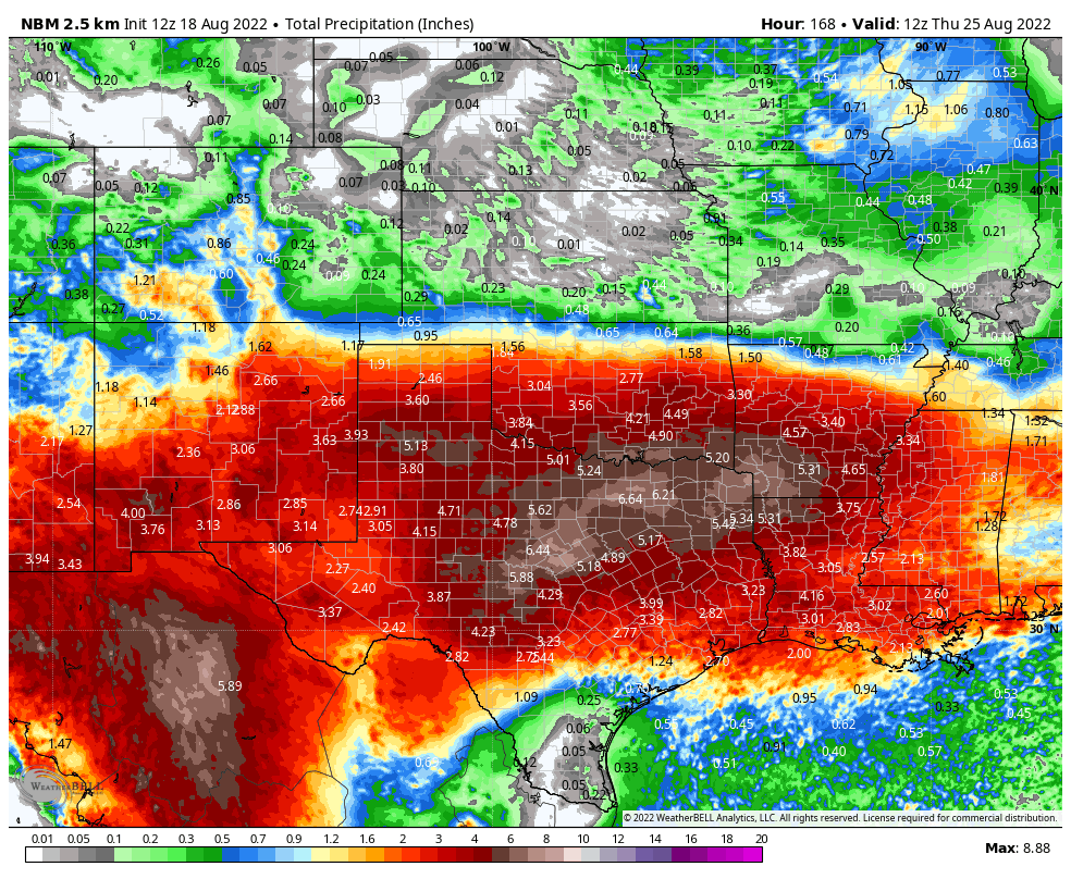
Looking at the forecast models and you have to be impressed by the widespread heavy rainfall totals they are forecasting over the next week areawide. Across the Southeastern Plains and nearby Guadalupe, Sacramento, and Capitan mountains our rainfall totals today into Monday morning are forecast to be in the 1" to 3" range. With pockets of 4" to 6" possible.
What is interesting is that many of our mountain reporting stations have already picked up 2" to 4" over the past couple of days. The Dog Canyon Raws has measured 4.17" of rain over the past 5 days.
Forecast models are notorious for underestimating rainfall totals in subtropical and tropical air masses over us so don't be surprised when this rainy spell is all done with next week to see some spots exceed 6".
Scattered to numerous rain showers and thunderstorms (some of which may be embedded) are forecast areawide today into the first of next week. These will be slow movers and we may even see some training of thunderstorms. Thus the flash flood risk is high areawide and most of New Mexico is under a Flash Flood Watch, especially for Friday and Saturday. Eddy and Lea Counties are not included at this time. We've already seen days of localized flash flooding over the past week over and near the burn scar areas in the mountains. Unfortunately, this situation will only get worse with time especially Friday into Sunday.
(Today Through 6 AM MDT Monday).

Weather Prediction Center 7-Day Rainfall Forecast.
(Today Through 6 AM MDT Thursday, August 25, 2022).

National Blend Of Models Rainfall Forecast.
(Today Through 6 AM MDT Monday).

National Blend Of Models 7-Day Rainfall Forecast.
(Today Through 6 AM MDT Thursday, August 25, 2022).
There Are None So Blind As Those Who "Will - Not" To See...107.


Comments
Post a Comment
Your comments, questions, and feedback on this post/web page are welcome.