My Current Weather

Wednesday, August 31, 2011

First Fall-Like Cold Front Sunday.

Click On The Maps To Enlarge Them.

Much Cooler By Sunday.

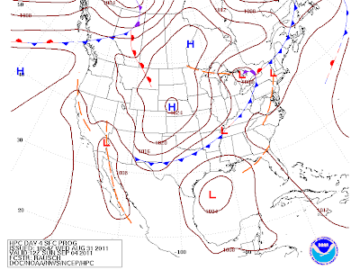
A fairly strong fall-like cold front (the meteorological fall starts this Thursday) is forecast to move into SE NM and W TX on Sunday. This will be the first major push of cooler air into the area of the season. If we are lucky enough we may only see our high temps in the 80's Sunday and Labor Day. Overnight low temps will drop down into the low 60's Monday morning, and a few spots may even dip down into the 50's.  


Valid 6 AM MDT Sun Sept 4, 2011.

High Temps Forecast For Sunday.


Low Temps Forecast Mon Morning.


New Daily Record High Temps Set Yesterday.


Yesterday Was Just Downright Hot!

Yesterday was really hot across SE NM. The highest reading I could find was 110 at the Paduca Raws, which is located near the WIPP Site. Not far behind was my 108 here at the house in Carlsbad, 107 at both the Carlsbad Climate Coop Station, and the Carlsbad Airport ASOS. The 8-Mile Draw Raws located northeast of Roswel checked in with 106, while the Artesia Climate Coop Station recorded 105. Not to be left behind were the Roswell and Hobbs Airports with 104, as well as the Hobbs, and Tatum Climate Coop Stations.

Tropical Storm Katia


Still looking for a Tropical Storm (Lee) to develop over the Gulf of Mexico by Friday.  A lot of uncertainty exists concerning the forecast track, and strength of this potential Tropical Storm/Hurricane. So anyone living along the Gulf of Mexico should keep up to date on this one. This Tropical Storm has the potential to bring some badly needed rainfall to South Texas, and nearby areas this holiday weekend.

The Truth Is Stranger Than Fiction!
Tuesday, August 30, 2011

Relief From The Heat Coming.

Click On The Maps To Enlarge Them.
Valid At 6 AM MDT Sun Sept 4, 2011.

It is one very hot day across SE NM today. As of 2 PM MDT. My thermometer here at my home in Carlsbad was reading 108. The Carlsbad Airport ASOS was registering 106, while the Paduca Raws, located near the WIPP Site was reporting 108. Other temps at 2 PM include, 104 at the Hobbs Airport, and 102 at both the Roswell and Artesia Airports.

Several stations have already broken their daily high temperature records for today, and a few are approaching their all-time monthly records. Its possible that we will see these readings go up another couple of degrees by 5 PM.

Cooler Temps Are Headed Our Way-
FSU 2M Temp Raws Anomalies Aug 30th - Sept 7, 2011.

Relief appears to be on the horizon. The models continue to forecast a fairly decent cold front (the seasons first-remember the meteorological fall begins Thursday) dropping southward down the eastern plains of the state, and into SE NM by around Sunday. Our high temperatures may only be around 90 or so by Sunday and Labor Day. There also appears to be a decent chance for t-storms across the area as the front moves through.

Record High Temps For Aug 30th-

Roswell (ThreadEx Station) 101 1959
Artesia Climate 105 1918
Carlsbad Climate 102 1943
Carlsbad Arpt ASOS 104 1959
Hobbs Climate 104 1959
Tatum Climate 101 1959

Temperature Records Are Courtesy Of-

NCDC ThreadEx Extremes
Midland NWS Climate Page
Western Regional Climate Center

Tropical Storm Katia.

Tropical Storm Katia At Noon MDT Today.

NHC Five Day Forecast Track Of Tropical Storm Katia.

NHC Tropical Outlook. 

Trouble is brewing for the Gulf of Mexico for later this week 
into the holiday weekend. This could become Tropical Storm
or Hurricane Lee by late in the week, or the weekend.


NWS HPC Precipitation Forecast.
Valid From 6 PM MDT Today - 6 PM MDT Sun Sept 4, 2011.

FSU GFS Forecast Valid At 6 AM MDT Sun Sept 4, 2011.

This mornings 12Z/6 AM MD,T FSU GFS 900 MB computer model forecast run, depicts a Major Hurricane (Katia) approaching the Windward Islands by this coming Sunday. It, along with several other models, are also forecasting the development of a (Tropical Storm/Hurricane?) in the Gulf of Mexico by this weekend. Not to mention the the cold front moving into the local area as well. Without a doubt, the Labor Day holiday weekend is going to be an interesting one for us, and for those who live along the Gulf Coast.

The Truth Is Stranger Than Fiction!

Monday, August 29, 2011

Hot - Isolated Afternoon T-Storms.

Click On The Maps To Enlarge Them.


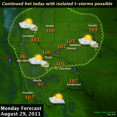
Another hot day is on tap for SE NM. We can expect high temps to range from 100 - 104 today into Wednesday. A few spots may see their daily record high temps tied or broken today into Wednesday. Forecast models are still calling for the possibility of a cold front slipping southward into the area this weekend. Should this scenario pan out then we would cool down about 10 -15-degrees and see an increase in t-storms.

Tropical Depression #12.


Tropical Depression #12 has formed about 395 miles south-southwest of the southern most Cape Verde Islands. It is moving off to the west at 15 mph. TD #12 is forecast to strengthen to a Tropical Storm within the next 48 hours, possibly within the next 12 hours. When this happens, this storm will be named Katia.

The Truth Is Stranger Than Fiction!

Sunday, August 28, 2011

Record Heat Today - Tuesday.

Click On The Maps To Enlarge Them.


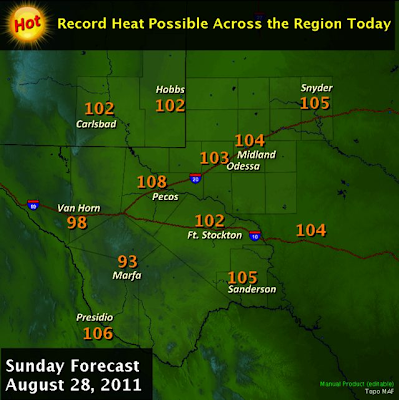
More heat, and continued very dry. This has been the story of our summer. Speaking of records, a few record high temps will be in danger of being tied, or broken across SE NM today into at least Tuesday. This summer has been one of the hottest on record. Take a look at the average daily high temperatures below.

Roswell Airport ASOS-

June 102.0
July 99.5
August 100.6

Artesia Climate-

June 101.5
July 100.3
August 100.8

Carlsbad Airport ASOS

June 103.9
July 100.8
August 101.5

Hobbs Climate-

June 101.0
July 100.8
August 100.9

Tatum Climate-

June 99.5
July 97.3
August 98.5

A couple of days ago I was talking about a cold front slipping southward down the eastern plains, and into the local area tonight or tomorrow. That's not going to happen. The front just will not have enough of a push to get this far south.

The models are forecasting a similar situation next weekend. The jet stream is starting to dig a little further southward across the northern US. So with time these cold fronts will get a little stronger, and will eventually get this far south. Meteorological fall begins Thursday, and like most of you I am ready for a break from the heat.

Looking Ahead To Katia.

NHC Outlook Map.

ECMWF 850 Wind Speed Swatch Forecast.
Valid From 6 PM MDT Aug 28 - 6 PM MDT Sept 6, 2011.

A tropical wave located a couple hundred miles SSE of the Cape Verde Islands this morning, continues to strengthen as it moves westward. It has the potential to become a Tropical Storm, and most likely a Hurricane later this week. If this happens it will be named Katia. Last nights 00Z/6 PM MDT run of the ECMWF model was forecasting it to develop into another Major Hurricane. The forecast map above has it approaching the Bahamas in about 10 days. Time will tell.

The Truth Is Stranger Than Fiction!

Friday, August 26, 2011

Radar Snapshots Of Hurricane Irene.

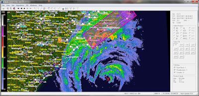
Here Are A Series Of GRLevel2-AE (Analyst) Radar
Snapshots Of Hurricane Irene. The Red X Marks The
Approximate Location Of Her Eye.

Click On The Maps To Enlarge Them.
#1 Hurricane Irene at 6:29 PM MDT. Irene was located about
130 miles SE of the Wilmington, NC Radar. She has sustained
winds of 100 mph with gusts near 120 mph. Her central pressure
was down to 950 millibars or 28.05" of mercury. Irene is moving
off to the north at 14 mph.

#2 Hurricane Irene at 10:10 PM MDT.

#3 Hurricane Irene moving inland near Cape Lookout, NC
at 5:30 AM MDT, Sat Aug 27, 2011.

#4 Hurricane Irene moving inland near Cape Lookout, NC
at 7:00 AM MDT, Sat Aug 27, 2011.

Visible Satellite Image Of Hurricane Irene. 6:45 AM MDT.

IR Rainbow Satellite Image Of H. Irene At 6:45 AM MDT.

#5 Hurricane Irene moving back over the water at 4:47 PM
MDT. Her eye was located about 22 miles SSE of Virginia
Beach, VA at this time. At 5PM MDT Irene had sustained
winds of 80 mph with gusts to near 100 mph. Her central
pressure was 950 millibars or 28.05". She is moving off
to the NNE at 16 mph.

Visible Satellite Image Of Hurricane At 4:15 PM MDT.

IR Rainbow Satellite Image Of Hurricane Irene At 4:15 PM MDT.

The Truth Is Stranger Than Fiction!

Hurricane Irene!

Click On The Images To Enlarge Them.


At 9:00 AM MDT, Hurricane Irene was located some 330 miles SSW of Cape Hatteras, North Carolina. She is moving off to the north at 14 mph. Irene has sustained winds of 105 mph with gusts to near 125 mph. Her central pressure is down to 946 millibars, or 27.93" of mercury.

Irene is huge, nearly 500 miles wide, and has to the potential to grow even bigger in aerial coverage. Irene is fixing to move over some very warm waters, as she nears the Outer Banks of North Carolina tomorrow morning. Currently she is forecast to move inland just after daybreak tomorrow, and then continue her track northward Saturday into Sunday into Southern New England.

Irene is forecast to strengthen between now and tomorrow morning when she moves inland across Eastern North Carolina, near the Outer Banks. She could come inland as a Major Hurricane, a Category 3! She has the real possibility of becoming a history maker!

More than 9 million (no that's not a typo people) are under Hurricane Watches or Warnings, and this number is expected to go up. Irene compares in size to Hurricane Ike. This may be the worst storm that most people along the Eastern US Seaboard, and Southern New England have experienced since 1944.
---------------------------------------------------------------------------------

Large-Scale Evacuations Under Way Ahead of Irene-

"With dangerous Hurricane Irene drawing closer to the East Coast, numerous large-scale evacuations are under way from the Carolinas north to the New York City area.
Thousands more near the Northeast coast could be told to evacuate later today, as confidence increases in Irene becoming one of the worst hurricanes to impact the region in decades.
The AccuWeather.com Hurricane Center continues to forecast Irene's landfall Saturday evening in eastern North Carolina as a major hurricane before a perilous encounter with the mid-Atlantic coast and New York City Sunday.
Such a track will impact millions, and officials are taking no chances by making evacuations mandatory and stressing that interrupted transportation will hinder any chances of emergency rescues."

Hurricane Irene's Impacts on East Coast Cities-

"AccuWeather.com Hurricane Center meteorologists continue to forecast Hurricane Irene will strike the Outer Banks of North Carolina on Saturday before taking aim at themid-Atlantic, New York City and New England.
Mandatory evacuation orders have been issued for thousands of coastal residents from North Carolina north to the New York City area, with many more sure to follow.
After the North Carolina landfall, Irene will pass close to or over the Delmarva Peninsula and New Jersey, then move on to the New York City area and interior New England.
The northern portion of this track is farther west and a bit slower than forecast earlier this week, and will result in more serious problems with heavy rain and damaging wind gusts farther west in New England and the northern mid-Atlantic.
Areas near and west of the center of Irene will have dangerous conditions related to flash and urban flooding. The flooding may be intensified in areas that have received torrential rainfall recently this month, such as coastal areas of the Northeast.
Areas near and east of the center of Irene will experience the strongest winds and related damage.


There is potential for a foot of rain along Irene's path, which can lead to life-threatening flooding."

The Truth Is Stranger Than Fiction!

Thursday, August 25, 2011

A Few T-Storms This Evening - Latest On Irene.

Click On The Images To Enlarge Them.


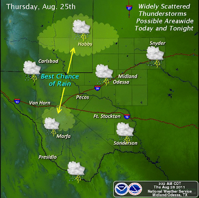
A weak cold front was draped across eastern New Mexico and West Texas this afternoon. A few widely scattered t-storms are firing up in the vicinity of this frontal boundary, and surface trough in SE NM, as a weak upper level disturbance moves into the area. Widely scattered t-storms should continue to increase across the local area this afternoon before dying out later this evening. These storms will have the ability to produce wind gusts near 50 mph, frequent cloud to ground lightning strikes, and perhaps a few heavy downpours.

Very little has changed in the overall thinking concerning our local weather for the rest of this week, as well as the weather across the area this weekend. Bottom line is that it will continue to remain hot and dry. A few scattered t-storms will dot the mountains but overall most us should not see rain after this evening. High temperatures tomorrow into the weekend will range from 100 -105. A cold front moving southward into the area late Sunday or early Monday, may cool us down a few degrees early next week, and increase our chances for t-storms. If we are lucky our high temperatures on Monday may only be in the mid 90's.

Hurricane Irene.

Click On The Maps To Enlarge Them.


Category 3 Hurricane Irene was located 575 miles south of Cape Hatteras, North Carolina at 3 PM MDT. Irene is moving off to the NNW at 14 mph. She has sustained winds of 115 mph with gusts near 140 mph. Her central pressure is down to 950 millibars or 28.05 inches of mercury.

-----------------------------------------------------------------------------------

Irene: Worst Effects on Northeast in 50 Years Possible-

"There is potential for the worst hurricane impacts in 50 years along the northern part of the Atlantic Seaboard as Irene plows northward.
The impacts on lives, property, commerce and travel will be serious.
While Irene is not forecast to track as far west, nor as fast, as Hazel did in 1954, it will ride up along the mid-Atlantic coast in such a way as to inflict major damage in many coastal and some inland communities. In today's dollars, Hazel was a multi-billion-dollar storm and reached Category 4 at peak intensity.
Irene will track farther east than Hazel, and farther west than Bob (1991). Meteorologist Heather Buchman compares Irene to storms in the past.

Many people along the Atlantic Seaboard probably have not experienced such a strong storm as we expect with Hurricane Irene. People in the path of Irene should stay indoors during the height of this storm.
Some of the youngest of the crowd were not around for Floyd (1999), Fran (1996), Gloria (1985) and others. Then there are the storms of the more distant generations of the 1960s and 1950s, which include Donna (1960), Diane (1955) and Hazel (1954)."


The Truth Is Stranger Than Fiction!

Wednesday, August 24, 2011

Heat & Irene.

Click On The Maps To Enlarge Them.


More Heat For SE NM.

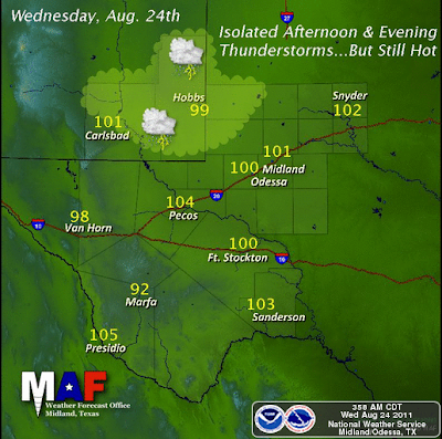
Very little change concerning our local weather is forecast today into the weekend. Hot afternoon temperatures with readings near 100 are forecast for today into Friday. Temperatures are forecast to ramp up a few degrees by the weekend, with readings ranging from 100 - 105.

A few isolated t-storms are expected across the area this afternoon into early this evening. Most places will not see rainfall and the best chances will be over the mountains.


A cold front is forecast by the models to approach the area late Sunday or on Monday. If this front is able to push far enough to the south, and into the local area, we would see cooler temperatures with an increased chance for t-storms. 

Major Hurricane Irene.


Hurricane Irene has strengthened to a Category 3 Hurricane. As of 6 AM MDT, Irene was located about 335 miles SE of Nassau in the Bahamas. She had sustained winds of 115 mph with higher gusts near 135 mph. Her central pressure was down to 957 millibars, or 28.26 inches of mercury. Irene is moving off to the WNW at 9 mph.

 Irene is a large Hurricane, and is forecast to continue to strengthen as she moves over warmer waters during the next two days. Conditions are nearly ideal for Irene to continue to strengthen, and she has the potential to strengthen into a Category 4 Hurricane by around midnight tonight, possibly even sooner. She could have sustained winds near 125 mph and gusts near 155 mph. 

The Truth Is Stranger Than Fiction!

NWS Albuquerque Burn Scar Matrix Forecast

Current NWS Watches/Warnings In Effect

New Mexico

Eddy County

Chaves County Plains & Mtn's

Culberson County

Lea County

Lincoln County

Otero County

Current US Temps

Current US Wind Chill/Heat Index Temperatures

NWS Midland Forecast

NWS Albuquerque Forecast

NWS Albuquerque Forecast

NWS El Paso Forecast

NWS Lubbock Forecast

NWS Lubbock Forecast

Average Daily High/Low Temperatures & Rainfall

Average Daily High/Low Temperatures & Rainfall