My Current Weather

Friday, May 31, 2019

Once Again Severe T-Storms Possible Today, Tonight, Saturday.


NWS NDFD Rainfall Forecast Totals.
(Today Through 6 AM MDT Monday).


Weather Prediction Center 7-Day Rainfall Forecast Totals.


Like a broken record that has been stuck in the same old grove playing the same song over and over again...our local weather forecasts once again promise rain and severe weather today into Saturday.

All of the severe weather parameters will come in to play today, this evening, and again Saturday. This includes scattered supercell thunderstorms that will produce large hail, damaging thunderstorm wind gusts in excess of 60 mph, deadly cloud to ground lightning, locally heavy rains that may lead to localized flash flooding. 

All I can say is look out when a storm does roll over us/you. It will be catch-up time in a hurry. Thunderstorms remain in our forecast through the weekend into next week too. 

(Issued At 10:27 AM MDT This Friday Morning).

..Texas to eastern NM...

   An isolated damaging wind and marginally severe hail risk should
   exist downstream of an ongoing short line segment in east-central
   TX. 2000-2500 J/kg of MLCAPE will be common ahead of this segment,
   with potential for additional development towards the Upper TX
   Coastal Plain this afternoon. Modest deep-layer shear should limit
   the potential for greater organization. 

   Farther west, weak mid/upper height rises will occur late today into
   tonight. Nevertheless, ample low-level moisture characterized by low
   to mid 60s surface dew points currently across the Pecos
   Valley/Permian Basin will foster scattered storm development over
   the higher terrain of southeast NM and the TX Trans-Pecos by late
   afternoon. A veering wind profile with height in conjunction with
   favorable speed shear from 500-250 mb should support a large hail
   risk along with isolated sig. Consolidation of convection into a
   small MCS tonight appears possible in parts of west TX. Increasingly
   weak 700-500 mb flow amid the height rises should limit organization
   potential and marginalize the risk for severe wind gusts.

Thunderstorm Produces Damages In Dexter Yesterday Afternoon.
(Courtesy Of Jim Tucker On Facebook).

Image may contain: sky and outdoor

Image may contain: sky, cloud, night, outdoor and nature

(6:47 PM MDT).


Quote- "Kudos to Lynn Coats, (aka Core Punch), for providing real time reports from a storm that produced strong winds and nickel sized hail. The storm crossed U.S. 285 at Ojibwa Road then proceeded in an easterly direction causing extensive damage including Rock Hill Dairy. I believe photo credit goes to Dexter Fire Chief Justin Powell, except for the shot from inside Lynn's vehicle."

The Truth Is Stranger Than Fiction - And Sometimes It Hurts!

Thursday, May 30, 2019

Much Cooler Today Along With Severe Thunderstorms.


Valid Today Through 6 PM MDT Monday.

(Issued At 6:55 AM MDT).

 ...Eastern New Mexico to west/south Texas...

   Initially, isolated strong to severe thunderstorms will be possible
   this morning across the Edwards Plateau near the Rio Grande. Hail is
   the most probable hazard. Otherwise, a front will continue to settle
   southward today across much of south/southwest Texas, with
   increasingly moist (albeit modestly so) low-level upslope
   trajectories gradually increasing across southwest Texas/southeast
   New Mexico, northward toward the Raton Mesa vicinity. Aside from
   evolving upslope/orographic lift, forcing for ascent will increase
   through peak heating with a northeastward-moving weak shortwave
   trough/modest speed max crossing New Mexico.

   The greatest combination of deep-layer shear and moderate/strong
   instability will exist from far southeast New Mexico across the
   Transpecos to Big Bend vicinity of southwest Texas, with supercells
   capable of large hail (perhaps locally significant) and perhaps some
   tornado risk most probable within this corridor.
Other more isolated
   severe storms will be possible as far north as the Raton Mesa
   vicinity/southeast Colorado.


   The increase of a southeasterly low-level jet this evening may allow
   for a general east/southeastward propagation this evening, possibly
   with upscale growth into one or more gradually accelerating
   clusters. This would increase the potential for locally damaging
   winds aside from hail, mainly across southwest Texas and the Rio
   Grande vicinity.

   ..Guyer/Broyles.. 05/30/2019


So far this has been one wild spring. Numerous severe weather events have affected the area with the most activity having occurred along and east of the NM/TX State line. This past holiday weekend saw several rounds of severe thunderstorms most notably in New Mexico this past weekend. Tornadoes were reported northeast of Roswell, south of Portales, near Dora, Logan, and Clayton. Hobbs was hit with 2" diameter hail (lime or hen egg size) while golf ball size hail was reported in Jal.

We are not done yet. For those of you who are hoping for rain its coming but more than likely with a price. Scattered thunderstorms are forecast for the local area today into Friday morning. Some of these will be of the supercell type which will produce large hail, damaging thunderstorm wind gusts in excess of 60 mph, frequent deadly cloud to ground lightning. Locally heavy rainfall and localized flash flooding will also be a concern especially over and near the mountains. This includes Eddy County and nearby areas.

A few tornadoes will also be possible with the supercell thunderstorms that fire along the stationary frontal boundary draped over the region. Tonight we may see a cluster of thunderstorms develop that could persists well into Friday morning. This will pose a damaging wind threat along with a heavy rain and flash flood threat. Storm total rainfall amounts could get up to around 3" maybe higher if training thunderstorms develop.

Thunderstorms are forecast to continue into the upcoming weekend.

The Truth Is Stranger Than Fiction - And Sometimes It Hurts!

Monday, May 27, 2019

Rain Everywhere But Not Here.


2-Day Rainfall Totals.


7-Day Rainfall Totals.


Kansas And Oklahoma 7-Day Rainfall Totals.


Although the dryline has been very active for the past week most of Southeastern New Mexico has missed out on the storms and thus the rain. The exception of course is Lea County and other New Mexico Counties located near the NM/TX State line. This is fairly common in May. May can either be bust or boom rainfall-wise for us and so far this year it has been mostly bust.

Then you have southern and southeastern Kansas and northern and extreme northeastern Oklahoma where 10" to 15" of rain has fallen in the past week alone. Severe to historical flooding continues in many of those areas. 

The Truth Is Stranger Than Fiction - And Sometimes It Hurts!

Sunday, May 26, 2019

Severe T-Storm Watch #255 In Effect Until 9 PM MDT For SE NM.


In Effect From 2:40 PM MDT Through 9:00 PM MDT.

 URGENT - IMMEDIATE BROADCAST REQUESTED
   Severe Thunderstorm Watch Number 255
   NWS Storm Prediction Center Norman OK
   340 PM CDT Sun May 26 2019

   The NWS Storm Prediction Center has issued a

   * Severe Thunderstorm Watch for portions of 
     Southeastern New Mexico
     West central Texas

   * Effective this Sunday afternoon and evening from 340 PM until
     1000 PM CDT.

   * Primary threats include...
     Scattered large hail and isolated very large hail events to 2
     inches in diameter likely.
     Scattered damaging wind gusts to 70 mph possible.
     A tornado or two possible.

   SUMMARY...Thunderstorms will develop along a dryline in New Mexico
   and spread east-northeastward into west central Texas this evening. 
   The initial storms will likely be supercells capable of producing
   large hail, and possible an isolated tornado.  Some upscale growth
   of storms into more of a line is possible this evening, with the
   potential for damaging gusts.

   The severe thunderstorm watch area is approximately along and 60
   statute miles east and west of a line from 25 miles north northeast
   of Cannon Afb NM to 15 miles southwest of Hobbs NM. For a complete
   depiction of the watch see the associated watch outline update
   (WOUS64 KWNS WOU5).

   PRECAUTIONARY/PREPAREDNESS ACTIONS...

   REMEMBER...A Severe Thunderstorm Watch means conditions are
   favorable for severe thunderstorms in and close to the watch area.
   Persons in these areas should be on the lookout for threatening
   weather conditions and listen for later statements and possible
   warnings. Severe thunderstorms can and occasionally do produce
   tornadoes.

   &&

   OTHER WATCH INFORMATION...CONTINUE...WW 252...WW 253...WW 254...

   AVIATION...A few severe thunderstorms with hail surface and aloft to
   2 inches. Extreme turbulence and surface wind gusts to 60 knots. A
   few cumulonimbi with maximum tops to 550. Mean storm motion vector
   24035.

   ...Thompson

The Truth Is Stranger Than Fiction - And Sometimes It Hurts!

Severe Thunderstorms Possible This Afternoon/Evening Across SE NM.


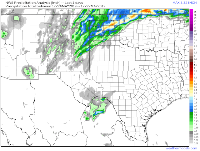
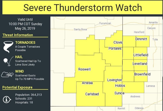
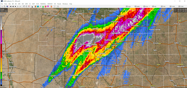
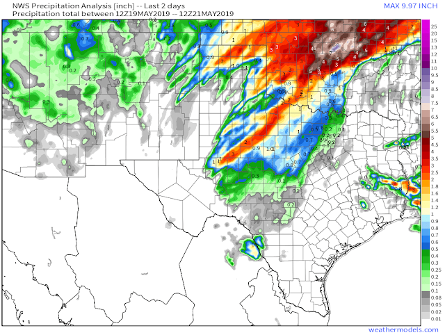
Storm Prediction Center Severe Weather Outlook Today.


Valid At 6 PM MDT This Afternoon.

NAM 3K Lifted Index Forecast.

Valid At 6 PM MDT This Afternoon.

NAM 3K Mid-Level Lapse Rate Forecast.

Valid At 6 PM MDT This Afternoon.

0-6 KM Bulk Shear Forecast.

Valid At 6 PM MDT This Afternoon.

Supercell Composite Forecast.

Valid At 6 PM MDT This Afternoon.

Significant Tornado Parameter Forecast.

Valid At 6 PM MDT This Afternoon.


Valid At 6 PM MDT This Afternoon.

Widely scattered to scattered thunderstorms are forecast to pop up along and east of the dryline this afternoon and evening across parts of Southeastern New Mexico and West Texas. Just exactly where the dryline is located late this afternoon and early this evening will be a big determining factor in where the storms are. 

As of 10:30 AM MDT widely scattered rain showers were already developing in western Lea County.

As of 10 AM MDT this morning the dryline is still hung up along the east slopes of the Guadalupe and Sacramento mountains...it had backed as far west as Dell City earlier this morning. It will mix eastward later this afternoon stalling somewhere near the Caprock, then back back westward around sunset. Dew point temperatures across the southeastern plains are in the mid 60's this morning.

Using this mornings 6 AM MDT NAM 3K forecast sounding and severe weather parameter forecasts it appears that we will be right on the edge of the dryline at 6 PM this afternoon. Should the dryline not mix as far east as currently forecast then there would be a greater chance for severe thunderstorms in and near the Pecos Valley today. 

This mornings severe weather parameter forecasts along with the SPC Day-1 Severe Weather Outlook indicate that any thunderstorm that does form will be severe. Supercell thunderstorms are likely along and east of the dryline.

Forecast Sounding Parameters.

No CAP/CIN.
High Temps Mid 90's.
Lifted Index values of -13C.
 Significant Tornado Parameter of 4.
0-6 KM Bulk Wind Shear values of 60 to 70 knots.
 Storm Relative Helicity values of 100-300 M2/S/2.
Surface based cape values are forecast to be in the 3,500 to 4,500 j/kg range.

The main severe weather threat appears to be large hail perhaps a few isolated cases of very large hail. Forecast soundings late this afternoon in northeast Eddy County indicate hail of around baseball size. 

Damaging thunderstorm wind gusts in excess of 60 mph will also be possible with any severe thunderstorm that develops. Frequent deadly cloud to ground lightning will accompany any thunderstorm. Remember "When Thunder Roars - Go Indoors."

Thunderstorms should begin to fire up around noontime as a short wave approaches from the southwest out of northwestern Mexico. 

Its not totally out of the question that a few tornadoes may also develop this afternoon and evening. 

Today will be a day to keep a close eye on our local weather and have a plan of action ready to implement should severe weather impact your location. 

The Truth Is Stranger Than Fiction - And Sometimes It Hurts!

Friday, May 24, 2019

Updated Severe Weather Outlook Today Into Sunday.


Blog Updated At 10:52 AM MDT Friday, May 24th, 2019.

Heavy Rains Fall West Of Lubbock.

Valid At 8 AM MDT Friday, May 24th, 2019.
GRLevel3 24-Hour Radar Estimated Rainfall.


Some of the heaviest rainfall reports with radar estimates colored in. Heaviest amount was likely 5 to 6 inches between Levelland and Morton.

Severe Weather Outlook Today - Sunday.


Thursday's Dryline Severe Thunderstorms In West Texas. 


The Truth Is Stranger Than Fiction - And Sometimes It Hurts!

Wednesday, May 22, 2019

Hit & Miss T-Storms To Return - Some Severe.


(May 19th - 21st, 2019).


Once again Southeastern New Mexico was left high and dry by the latest storm to impact the state and area. Not necessarily a bad thing considering the magnitude and scope of the severe weather that has impacted our neighbors.

(As Of 11 PM MDT Tuesday, May 21st, 2019).


Valid At Midnight Last Night.

GFS 500 MB/18,000' MSL Forecast.

Valid At 6 AM MDT Thursday Morning.


Valid At Midnight Tonight.

(Thursday).


Valid Tonight Through 6 PM MDT Monday, May 27th, 2019.


A very active May weather pattern continues to make life interesting across the area. Our latest storm has moved out of the state while another one waits to our northwest. 

Its May and we are rolling into the heart of our severe weather season (mid May - mid June). The dryline has been very active this year and this will be the case again tonight into the upcoming holiday weekend. It is forecast to slosh back and forth across West Texas and the Eastern third of New Mexico into the weekend. 

A series of mid and upper level disturbances will interact with the sloshing dryline from time to time beginning tonight continuing into the weekend to produce rounds of scattered thunderstorms locally. Some of these will become severe at times and will be capable of producing large hail, damaging thunderstorm wind gusts, deadly cloud to ground lightning, heavy rainfall and localized flash flooding, and a few tornadoes.

Round one begins tonight along and near the NM/TX State line. This is going to be another hit and miss event. Those who get rain over the next five days or so could get storm totals of 1" to 3". But it will come at a price and not everyone is going to see that much rain. The price will be severe thunderstorms. For the short term Thursday appears to be the most likely and active day locally for severe weather.

(Valid As Of 9:14 PM MDT Tuesday, May 21, 2019).

PUBLIC INFORMATION STATEMENT
NATIONAL WEATHER SERVICE ALBUQUERQUE NM
914 PM MDT TUE MAY 21 2019

PRELIMINARY SNOW REPORTS ACROSS NORTH AND CENTRAL NEW MEXICO
FOR THE LAST 25 HOURS.

...COUNTY...                     STORM TOTAL   TIME/DATE OF
   LOCATION                       /INCHES/      MEASUREMENT

...COLFAX COUNTY...
   RATON                             4.5        820 AM  5/21
   EAGLE NEST 8 SE                   3.0        500 AM  5/21
      - TOLBY SNOTEL.
   RATON 1 N                         2.3        915 AM  5/21
   RATON 1 ENE                       2.2        630 AM  5/21

...RIO ARRIBA COUNTY...
   CUBA 9 E                          7.0        400 AM  5/21
      - VACAS LOCAS SNOTEL.
   CANON PLAZA 11 NNW                6.0        800 PM  5/20
      - HOPEWELL SNOTEL.
   TRUCHAS 1 ESE                     4.9        915 AM  5/21
   SAN MIGUEL 8 SSW                  1.0        800 PM  5/20
      - SAN ANTONIO SINK SNOTEL.
   CANJILON 7 E                      1.0        800 PM  5/20
      - BATEMAN SNOTEL.
   CHAMA 5 NW                        1.0        800 PM  5/20
      - CHAMITA SNOTEL.

...SAN JUAN COUNTY...
   TOADLENA 5 SSW                    8.0        100 AM  5/21
      - NAVAJO WHISKEY CREEK SNOTEL.

...SAN MIGUEL COUNTY...
   ROCIADA 8 SW                      5.0        400 AM  5/21
      - WESNER SPRINGS SNOTEL.

...SANDOVAL COUNTY...
   CUBA 7 ESE                        4.0        200 AM  5/21
      - SENORITA DIVIDE SNOTEL.

...SANTA FE COUNTY...
   TERERRO 6 WNW                     8.0        100 AM  5/21
      - SANTA FE SNOTEL.
   GLORIETA 8 NNW                    1.0        500 AM  5/21
      - ELK CABIN SNOTEL.

...TAOS COUNTY...
   ARROYO SECO 8 NE                  6.0        800 PM  5/20
      - TAOS POWDERHORN SNOTEL.
   LLANO LARGO 5 SSE                 6.0        200 AM  5/21
      - RIO SANTA BARBARA SNOTEL.
   TRES RITOS 4 NNW                  3.0        800 PM  5/20
      - GALLEGOS PEAK SNOTEL.

...UNION COUNTY...
   CAPULIN                           6.0       1030 AM  5/21
   FOLSOM                            4.6        800 AM  5/21

PRELIMINARY RAINFALL REPORTS ACROSS NORTH AND CENTRAL NEW MEXICO
FOR THE LAST 25 HOURS.

...COUNTY...                    STORM TOTAL    TIME/DATE OF
   LOCATION                      /INCHES/       MEASUREMENT

...BERNALILLO COUNTY...
   ALBUQUERQUE 2 N                  0.27        707 AM  5/21
      - MONTANO AND EDITH.
   ALBUQUERQUE 6 NE                 0.26        706 AM  5/21
   ALBUQUERQUE 8 ENE                0.25        915 AM  5/21
      - SPAIN AND IMPERATA.
   CARNUEL 6 NW                     0.24        915 AM  5/21
   ALBUQUERQUE 7 NE                 0.24        708 AM  5/21
      - SPAIN AND JUAN TABO.
   ALBUQUERQUE 8 ENE                0.23        915 AM  5/21
      - ACADEMY AND IMPERATA.
   CANONCITO 7 WNW                  0.20        915 AM  5/21
   SANDIA PARK 8 W                  0.20        710 AM  5/21
   ALBUQUERQUE 6 NE                 0.19        705 AM  5/21
      - SPAIN AND MORRIS.
   SANDIA PARK 8 W                  0.19        915 AM  5/21
   ALBUQUERQUE 7 E                  0.19        710 AM  5/21
      - COMANCHE AND TRAMWAY.
   ALBUQUERQUE 2 E                  0.18        915 AM  5/21
      - CANDELARIA AND CARLISLE.
   ALBUQUERQUE 6 ENE                0.17        704 AM  5/21
      - COMANCHE AND JUAN TABO.
   ALBUQUERQUE 2 E                  0.17        915 AM  5/21
      - AZTEC AND SAN MATEO.
   ALBUQUERQUE 3 NNE                0.15        915 AM  5/21
      - VISTA DEL NORTE AND LAS LOMITAS.
   CEDRO 4 WSW                      0.15        713 AM  5/21
      - SANDIA LAB RAWS.
   ALBUQUERQUE 4 NE                 0.15        703 AM  5/21
   ALBUQUERQUE 2 ENE                0.15        710 AM  5/21
   ALBUQUERQUE 3 SE                 0.15        915 AM  5/21
      - CONSTITUTION AND WASHINGTON.
   ALBUQUERQUE 7 E                  0.14        915 AM  5/21
      - INDIAN SCHOOL AND CHELWOOD PARK BLVD.
   ALBUQUERQUE 3 SE                 0.13        915 AM  5/21
      - SAN MATEO AND COPPER.
   ALBUQUERQUE 8 ESE                0.13        915 AM  5/21
      - COPPER AND SUPPER ROCK.
   ALBUQUERQUE 6 NNE                0.12        711 AM  5/21
   ALBUQUERQUE 5 NE                 0.12        915 AM  5/21
      - SAN ANTONIO AND LOUISIANA.
   ALBUQUERQUE 8 ESE                0.12        610 AM  5/21
      - INDIAN SCHOOL AND TRAMWAY.
   ALBUQUERQUE 2 SE                 0.12        915 AM  5/21
      - CONSTITUTION AND CARLISLE.
   ALBUQUERQUE 9 NE                 0.12        915 AM  5/21
      - TRAMWAY AND LIVE OAK ROAD.
   ALBUQUERQUE 5 ESE                0.12        915 AM  5/21
      - WYOMING AND COPPER.
   ALBUQUERQUE 7 ESE                0.11        915 AM  5/21
      - CONSTITUTION AND CHELWOOD PARK BLVD.
   ALBUQUERQUE 3 E                  0.10        712 AM  5/21
      - SOUTH FORK OF HAHN ARROYO.
   ALBUQUERQUE 4 SSE                0.10        915 AM  5/21
      - ZUNI AND SAN MATEO.
   ALBUQUERQUE 5 NE                 0.10        915 AM  5/21
      - SAN FRANCISCO AND BARSTOW.

...CATRON COUNTY...
   RESERVE 1 WNW                    0.29        653 AM  5/21
      - RESERVE RAWS.
   RESERVE 1 WNW                    0.20        653 AM  5/21
   OMEGA 8 NNE                      0.16        915 AM  5/21
   BEAVERHEAD                       0.16        651 AM  5/21
      - BEAVERHEAD RAWS.
   OLD HORSE SPRINGS 19 SSE         0.15        652 AM  5/21
      - PELONA MOUNTAIN RAWS.
   LUNA 1 ENE                       0.12        651 AM  5/21
      - LUNA RAWS.
   OMEGA 8 NNW                      0.12        915 AM  5/21

...LOS ALAMOS COUNTY...
   WHITE ROCK 1 W                   0.12        655 AM  5/21

...MCKINLEY COUNTY...
   GALLUP 1 SSE                     0.25        915 AM  5/21

...RIO ARRIBA COUNTY...
   SANTA CRUZ 2 SSW                 0.18        915 AM  5/21
   DULCE 18 SW                      0.16        646 AM  5/21
   ALCALDE 4 NE                     0.16        915 AM  5/21
   ESPANOLA 6 WNW                   0.14        915 AM  5/21
   EL VADO 11 W                     0.10        647 AM  5/21
      - PORTABLE RAWS.
   MONERO 12 S                      0.10        654 AM  5/21
      - STONE LAKE RAWS.

...SAN JUAN COUNTY...
   FARMINGTON 3 WSW                 0.86        915 AM  5/21
   FARMINGTON 1 WSW                 0.69        915 AM  5/21
   FARMINGTON 3 NE                  0.67        915 AM  5/21
   FARMINGTON 4 WSW                 0.61        915 AM  5/21
   FLORA VISTA 4 SSW                0.52        915 AM  5/21
   AZTEC 2 WSW                      0.51        915 AM  5/21
   CEDAR HILL 1 ESE                 0.47        915 AM  5/21
   FLORA VISTA 1 ESE                0.46        915 AM  5/21
   FARMINGTON 3 SSW                 0.44        915 AM  5/21
   AZTEC 5 E                        0.41        915 AM  5/21
   BLOOMFIELD 2 N                   0.40        915 AM  5/21
   AZTEC 1 ESE                      0.33        915 AM  5/21
   BLOOMFIELD 1 NE                  0.31        915 AM  5/21
   SHIPROCK 2 S                     0.17        915 AM  5/21
   NAVAJO DAM 12 N                  0.13        645 AM  5/21
      - ALBINO CANYON RAWS.

...SANDOVAL COUNTY...
   CORRALES 1 ENE                   0.43        915 AM  5/21
   CANONES 1 N                      0.33        915 AM  5/21
   CUBA 9 SW                        0.33        647 AM  5/21
      - CUBA RAWS.
   PLACITAS 2 NE                    0.23        915 AM  5/21
   PLACITAS 1 NNW                   0.22        915 AM  5/21
   BERNALILLO 3 E                   0.18        706 AM  5/21
   RIO RANCHO 2 S                   0.17        709 AM  5/21
      - NM528 AND HIGH RESORT BLVD
   CORRALES 1 E                     0.17        708 AM  5/21
   PLACITAS 2 WNW                   0.16        915 AM  5/21
   SANTA ANA PUEBLO 3 SE            0.15        705 AM  5/21
   SANTA ANA PUEBLO 2 SSW           0.14        915 AM  5/21
   CORRALES 2 WNW                   0.14        704 AM  5/21
   RIO RANCHO 2 SW                  0.13        915 AM  5/21
      - SOUTHERN AND SARA.
   CORRALES 2 WNW                   0.13        915 AM  5/21
   CORRALES 1 NNE                   0.12        915 AM  5/21
   RIO RANCHO 2 ESE                 0.11        915 AM  5/21
      - NORTHERN AND IDALIA.
   CORRALES 2 N                     0.11        915 AM  5/21
   CORRALES 2 ESE                   0.11        712 AM  5/21
      - SANDIA LAKES RAWS.
   RIO RANCHO 1 ENE                 0.10        915 AM  5/21
      - KIM AND IDALIA.
   RIO RANCHO                       0.10        915 AM  5/21
      - NORTHERN AND LOMA COLORADO.

...SANTA FE COUNTY...
   NAMBE 1 W                        0.31        915 AM  5/21
   CUYAMUNGUE 1 SE                  0.25        915 AM  5/21
   TESUQUE                          0.21        701 AM  5/21
   STANLEY 7 NE                     0.17        915 AM  5/21
   JACONITA                         0.16        530 AM  5/21
   SANTA FE 1 NNW                   0.15        702 AM  5/21
   SANTA FE 3 WNW                   0.15        915 AM  5/21
   SANTA FE                         0.13        659 AM  5/21
   TESUQUE 1 W                      0.13        701 AM  5/21
   TESUQUE 6 WSW                    0.13        701 AM  5/21
   POJOAQUE PUEBLO 1 ESE            0.13        915 AM  5/21
   EL RANCHO 1 WNW                  0.13        915 AM  5/21
   LOS CERRILLOS 3 NNE              0.12        915 AM  5/21
   LOS CERRILLOS 5 ENE              0.11        915 AM  5/21
   SANTA FE 1 ENE                   0.11        915 AM  5/21
   AGUA FRIA 2 E                    0.10        915 AM  5/21

...TAOS COUNTY...
   LOS CORDOVAS 2 SSW               0.29        915 AM  5/21
   TALPA 1 SE                       0.19        658 AM  5/21
   RANCHOS DE TAOS 1 SSW            0.18        915 AM  5/21
   ARROYO SECO 3 SW                 0.16        659 AM  5/21
   TAOS 2 SSE                       0.15        658 AM  5/21
   TALPA 1 NE                       0.15        658 AM  5/21
   VALDEZ 2 W                       0.14        915 AM  5/21
   QUESTA 1 NNW                     0.14        915 AM  5/21

...TORRANCE COUNTY...
   ABO 2 N                          0.30        915 AM  5/21
   ABO 3 NE                         0.25        915 AM  5/21
   ABO 3 N                          0.24        715 AM  5/21
   MOUNTAINAIR 1 S                  0.23        915 AM  5/21
   MOUNTAINAIR                      0.23        915 AM  5/21
   MOUNTAINAIR 1 W                  0.19        716 AM  5/21
      - MOUNTAINAIR RAWS.
   MOUNTAINAIR 4 W                  0.19        915 AM  5/21
   ESTANCIA 7 WSW                   0.18        915 AM  5/21
   MOUNTAINAIR 2 W                  0.17        715 AM  5/21
   ESTANCIA 6 WSW                   0.15        915 AM  5/21
   CLINES CORNERS 1 SSE             0.11        714 AM  5/21
      - KCQC ASOS.

...UNION COUNTY...
   CLAYTON 2 ENE                    0.99        718 AM  5/21
      - KCAO ASOS.
   DES MOINES 7 ESE                 0.52        915 AM  5/21
   CLAYTON 2 ENE                    0.43        915 AM  5/21
   CLAYTON 15 SSW                   0.23        915 AM  5/21
   GRENVILLE 7 ENE                  0.22        915 AM  5/21
   CLAYTON 2 WSW                    0.20        915 AM  5/21
   CLAYTON 6 NE                     0.19        915 AM  5/21
   CLAYTON 1 SSE                    0.18        915 AM  5/21
   CLAYTON 1 W                      0.12        915 AM  5/21

...VALENCIA COUNTY...
   PERALTA 1 S                      0.19        915 AM  5/21
   VALENCIA 2 S                     0.18        915 AM  5/21
   VALENCIA 1 NNE                   0.17        707 AM  5/21
   VALENCIA 1 E                     0.17        915 AM  5/21
   RIO COMMUNITIES 6 SE             0.16        915 AM  5/21
   PERALTA 2 SSE                    0.15        915 AM  5/21
   RIO COMMUNITIES                  0.10        915 AM  5/21

PRELIMINARY PEAK NON-THUNDERSTORM WIND GUST REPORTS ACROSS NORTH AND CENTRAL NEW
MEXICO FOR THE LAST 25 HOURS.

...COUNTY...                      PEAK GUST    TIME/DATE OF
   LOCATION                         /MPH/       MEASUREMENT

...CHAVES COUNTY...
   BITTER LAKE WILDLIFE REF 14 NNE    57       1037 AM  5/21
      - EIGHT MILE DRAW RAWS.
   DUNKEN 2 NE                        49        336 PM  5/21
      - DUNKEN RAWS.

...COLFAX COUNTY...
   ANGEL FIRE 2 NNW                   51        315 PM  5/21
      - KAXX AWOS.

...CURRY COUNTY...
   CLOVIS 2 SE                        67        224 PM  5/21
   CANNON AFB 1 N                     59       1217 PM  5/21
      - KCVS ASOS.
   CLOVIS 1 SSW                       58        142 PM  5/21
   TEXICO 3 NNW                       55       1105 AM  5/21
      - KCVN AWOS.

...GUADALUPE COUNTY...
   SANTA ROSA 2 ESE                   60       1055 AM  5/21
      - KSXU AWOS.
   VAUGHN 4 NE                        56        955 AM  5/21
   SANTA ROSA 2 WSW                   54       1250 PM  5/21
   MILAGRO 3 ESE                      53       1115 AM  5/21
   SANTA ROSA 7 ENE                   50       1010 AM  5/21
   PASTURA 2 NE                       47        940 AM  5/21

...LINCOLN COUNTY...
   RUIDOSO 1 NNW                      57        600 PM  5/21
      - SMOKEY BEAR RAWS.
   FORT STANTON 2 SSW                 52        515 PM  5/21
      - KSRR AWOS.
   NOGAL 5 NW                         48        615 PM  5/21

...QUAY COUNTY...
   TUCUMCARI 7 ENE                    53        353 PM  5/21
      - KTCC ASOS.

...ROOSEVELT COUNTY...
   TOLAR 13 SE                        58       1039 AM  5/21
      - K4MR AWOS.
   TOLAR 13 SE                        57       1114 AM  5/21
      - MELROSE RANGE RAWS.

...SAN MIGUEL COUNTY...
   SAN MIGUEL 3 SSW                   52       1259 PM  5/21
   LAS VEGAS 6 NE                     47        420 PM  5/21
      - KLVS ASOS.

...SANDOVAL COUNTY...
   FRIJOLES                           46        608 PM  5/21
      - TOWER RAWS.

...SOCORRO COUNTY...
   BINGHAM 20 S                       47        530 PM  5/21
   BOSQUE DEL APACHE REFUGE 28 SE     46        500 PM  5/21
   BOSQUE DEL APACHE REFUGE 11 SE     46        405 AM  5/21

...TORRANCE COUNTY...
   CLINES CORNERS 1 SSE               46       1053 AM  5/21
      - KCQC ASOS.

PRELIMINARY SUSTAINED WIND REPORTS ACROSS NORTH AND CENTRAL NEW
MEXICO FOR THE LAST 25 HOURS.

...COUNTY...                     WIND SPEED    TIME/DATE OF
   LOCATION                         /MPH/       MEASUREMENT

...CURRY COUNTY...
   CANNON AFB 1 N                     45       1111 AM  5/21
      - KCVS ASOS.
   TEXICO 3 NNW                       37        858 AM  5/21
      - KCVN AWOS.

...GUADALUPE COUNTY...
   SANTA ROSA 2 ESE                   46        955 AM  5/21
      - KSXU AWOS.

$$

SHOEMAKE

Southern New Mexico Peak Wind Gusts.

Public Information Statement
Spotter Reports
National Weather Service El Paso TX
1218 AM MDT Wed May 22 2019

The following are unofficial peak wind observations for Tuesday, May
21. Appreciation is extended to Skywarn spotters, news media, and
mesonet operators including West Texas Mesonet and the Dona Ana
County Flood Commission. This summary also is available on our home
page at weather.gov/ElPaso.

***********************PEAK WIND GUST***********************

LOCATION             MAX WIND     TIME/DATE   COMMENTS                   
                        GUST            OF 
                         MPH    MEASUREMENT

NEW MEXICO

...Dona Ana County...
   San Augustin Pass       72   345 PM  5/21  ELEV 5902 FT WMSR       
   1 SE WSMR Main Post     53   540 PM  5/21  ELEV 4275 FT WSMR       
   7 SW Northrup Strip     51   515 PM  5/21  ELEV 4039 FT WSMR       
   5 NE San Augustin Pa    50  1150 PM  5/21  ELEV 5046 FT WSMR       
   5 ENE WSMR Main Post    49   310 PM  5/21  ELEV 3955 FT WSMR       
   11 SW Northrup Strip    49   520 PM  5/21  ELEV 4321 FT WSMR       
   1 SE WSMR Main Post     49   810 AM  5/21  ELEV 4190 FT WSMR       
   WSMR Main Post          49   510 PM  5/21  ELEV 4242 FT WSMR       
   18 NE WSMR Main Post    48   340 PM  5/21  ELEV 3951 FT WSMR       
   Lookout Peak            47   645 PM  5/21  ELEV 5655 FT CWOP       
   6 ESE WSMR Main Post    43   255 AM  5/21  ELEV 4006 FT WSMR       
   11 NE Organ             41   301 PM  5/21  ELEV 6138 FT RAWS       
   5 WNW Santa Teresa      41   405 PM  5/21  ELEV 4115 FT RSOIS      
   Northrup Strip          40   455 PM  5/21  ELEV 3907 FT WSMR       

...Grant County...
   12 E Redrock            47   559 PM  5/21  ELEV 6965 FT RAWS       
   4 WSW Silver City       40   658 PM  5/21  ELEV 6348 FT CWOP       
   3 NE Faywood            40   530 PM  5/21  ELEV 5644 FT DTN        

...Hidalgo County...
   15 SSW Hachita          51  1140 PM  5/21  ELEV 4291 FT RAWS       
   6 WSW Lordsburg         46   205 PM  5/21  ELEV 4265 FT NMDOT      
   2 NE Road Forks         45   535 PM  5/21  ELEV 4158 FT NMDOT      
   6 NE Road Forks         42   700 PM  5/21  ELEV 4148 FT NMDOT      
   4 NE Road Forks         42   245 PM  5/21  ELEV 4153 FT NMDOT      
   5 NE Road Forks         41   410 PM  5/21  ELEV 4149 FT NMDOT      

...Luna County...
   11 NNE Deming           43   845 PM  5/21  ELEV 4692 FT DTN        
   2 SE Deming             40   900 PM  5/21  ELEV 4308 FT NMED       

...Otero County...
   3 NW Mayhill            53   634 PM  5/21  ELEV 7160 FT WXUND      
   Sixteen Springs         52   247 PM  5/21  ELEV 7377 FT CWOP       
   Mescalero               47   541 PM  5/21  ELEV 6227 FT RAWS       
   28 ENE Orogrande        46  1237 AM  5/21  ELEV 4886 FT RAWS       
   1 NNE Mayhill           45   101 PM  5/21  ELEV 6471 FT RAWS       
   1 S Sunspot             43   600 PM  5/21  ELEV 9190 FT WXUND      
   Cloudcroft              42   155 PM  5/21  ELEV 8670 FT AWS        
   14 WNW Orogrande        42   230 AM  5/21  ELEV 4040 FT WSMR       
   Sunspot                 40   310 PM  5/21  ELEV 9255 FT WSMR       
   9 W Tularosa            40   530 PM  5/21  ELEV 4050 FT WSMR       

...Sierra County...
   20 WNW Tularosa         47   155 PM  5/21  ELEV 4055 FT WSMR       
   Winston                 42   550 PM  5/21  ELEV 6192 FT EPZWXN     

TEXAS

...El Paso County...
   South Franklin Peak     56   239 PM  5/21  ELEV 6614 FT CWOP       
   13 NNE El Paso          56   914 PM  5/21  ELEV 4055 FT AWS        
   Clint                   53   229 PM  5/21  ELEV 3640 FT WXUND      
   10 NNE El Paso          53  1000 PM  5/21  ELEV 3958 FT TCEQ       
   5 NNE El Paso           49  1103 PM  5/21  ELEV 3998 FT AWS        
   6 NE El Paso            46   326 PM  5/21  ELEV 3905 FT AWS        
   5 ESE El Paso           41   200 PM  5/21  ELEV 3681 FT TCEQ       
   11 NE El Paso           41  1016 PM  5/21  ELEV 4007 FT CWOP       
   2 WNW El Paso           40   200 PM  5/21  ELEV 3799 FT TCEQ       

$$

BIRD


The Truth Is Stranger Than Fiction - And Sometimes It Hurts!

NWS Albuquerque Burn Scar Matrix Forecast

Current NWS Watches/Warnings In Effect

New Mexico

Eddy County

Chaves County Plains & Mtn's

Culberson County

Lea County

Lincoln County

Otero County

Current US Temps

Current US Wind Chill/Heat Index Temperatures

NWS Midland Forecast

NWS Albuquerque Forecast

NWS Albuquerque Forecast

NWS El Paso Forecast

NWS Lubbock Forecast

NWS Lubbock Forecast

Average Daily High/Low Temperatures & Rainfall

Average Daily High/Low Temperatures & Rainfall